Click here to start reading Part I.
I continued my trend of waking up early at Elk Lake and was again on the trail by 8am. Mostly I was ready to leave Elk Lake Hut behind me. My next stop was Walt Hut Hill, which most people say is their second favourite hut, so I was ready to get going – plus I had a feeling it would have cell service and I was looking forward to talking to my family.
It’s only 14km between Elk Lake and Walt Hill, so it would be my shortest day on the trail. I wasn’t sure how I would feel about finishing so early in the day, but I figured my body could probably use a bit of a break and that Walt Hill was a good place for it.
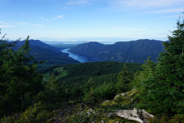
I left Elk Lake and noticed that the trail had been freshly weed-whacked. This made it easier to go through the brush, but it was also a bit of a hazard slipping over the dead grass covered in the morning dew. There were two routes down from Elk Lake – in the hut guest book, someone had recommended the “outside route” so I opted for that one. There was one view right at the beginning, but other than that it’s all in the woods, so I’m not sure what makes one route better than another, but I ran into a bunch of the PRPAWS volunteers on the outside route, so I was thrilled to have selected that one!
PRPAWS stands for Powell River Parks and Wilderness Society. It’s a volunteer society that is responsible for maintaining the trail. The Sunshine Coast Trail is hands down the most well signed and maintained trail I’ve ever been on it, and it’s entirely thanks to these fine individuals! I ran into 2 guys with weed whackers that were heading up the trail to continue clearing the brush. I had a nice chat with them and they told me they volunteer with trail maintenance every Tuesday and Thursday! Well done!

They informed me I was very lucky because a bit further down the trail, Eagle Walz himself was out doing trail maintenance! Eagle Walz founded the trail back in 1992, authored the trail guidebook everyone uses, and has dedicated 30 years of his life to the trail! He was out weed whacking too and it was lovely to have the opportunity to chat with him. He was still out taking notes about the trail and asked to see my copy of the guidebook to check some things for himself. I asked him about starting the trail and he told me that at the time (1992), Powell River had 5 major trails and he incorporated 4 of them into what is now the SCT. He said there were a lot of considerations in planning the trail, one of the most important of which was water – not just because of it’s obvious importance for survival, but because streams often get some protection from logging companies and those set-backs can extend to the adjacent trail.
I met a local day hiker later in the day that told me there were a lot of huts throughout the sunshine coast because the community groups often receive funding from logging companies when they cut down community forests (seems a very small reward to me). The SCT storyboard at the end of the trail also indicated that construction first started on the huts in 2009 when PRPAWS received a large grant and constructed more than half the huts in just 5 years! I asked Eagle what his favourite section of the trail is and he told me “whatever section I’m currently working on”, so it was great to run into him on his favourite part!

I left the conversation feeling rejuvenated again and continued on towards Coyote Lake, which was my halfway point for the day. I was planning to swim there, but Coyote Lake was NOT an appealing swim location, so I ended up just filling up my water instead. It was definitely the worst place I collected water from, but it was the only reliable source for the day and there was no water at Walt Hill, so I didn’t have much choice. I was forced to carry another 10lbs of water weight up to Walt Hill, but fortunately it was no where near as challenging as Tin Hat Hut, so it didn’t bother me too much.

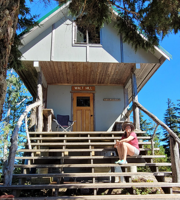
Since I only had to hike 14km, I arrived at Walt Hill around 1pm. I was a bit worried about having so much downtime, but Walt Hill has such amazing views, that I didn’t find it as difficult to kill an afternoon there and liked having a proper break. The hut at Walt Hill is totally enclosed (my favourite as they feel the safest), and there was a camp chair out on the porch. I set up the chair overlooking the bluffs and had a great afternoon catching up with my family while enjoying the view. Besides the PRPAWS volunteers, the above-mentioned day hiker showed up, who I had a great conversation with about the backcountry, but otherwise, I was alone at the hut again.
I ate my supper on the porch and enjoyed watching the sun set. Walt Hill was the most comfy for me because there were a bunch of large foam pads up in the loft and I opted to use these instead of my thermarest, which was extra comfy. I had another big day ahead of me, so I opted to go to bed early and get up to watch the sunrise over the bluffs.
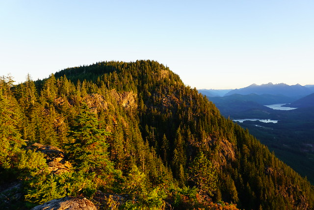
The next day I was back on the trail before it was even properly bright and had one of my most ambitious mornings since Inland Lake. It’s a long hike down through the forest towards Lang Bay, but I made really good time. There’s no real attractions until you get to Lois Lake, so I decided to push through to the lake before taking a real break. I ended up hiking 17km to the Lois Lake Rec Site before noon, which was a new record for me.
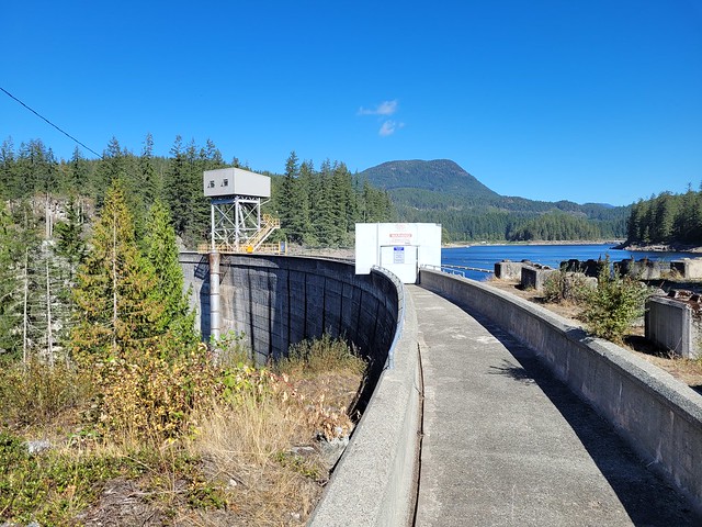
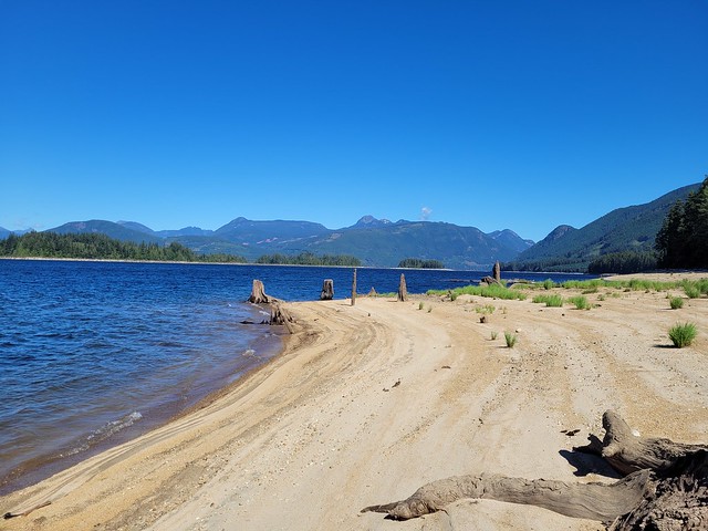
I was planning to take a nice long break at the lake, but it was very windy and I quickly got cold, so I had my lunch and then decided to push 2kms further to the Lois Point Rec Site. Lois Lake is interesting, it’s a reservoir, but they never properly cleared all the trees when they impounded the reservoir, so there are still large stumps everywhere when the water level is low, which it was on this occasion.
Unfortunately continuing on to Lois Point wasn’t a good idea. I only had 4km to go to Golden Stanley hut, so I wanted to kill some time at the lake so I wouldn’t have too much time alone at the hut. But the Lois Point Rec Site was extremely dicey and I didn’t feel comfortable stopping there. The Lois Lake site is pretty standard car camping, but Lois Point definitely attracts a different crowd. There were a lot of decrepit campervans and trucks, empty beer cans everywhere, as well as some tent shanty’s set up on the beach. I could see a few men on the beach where I’d been planning to hang out, but I was getting a bad vibe, so I snuck off along the trail and bushwhacked back to the lake about a kilometer further because I still had to filter water for the night. It was a lovely place with sandy beaches, but still very windy, so I got my water and moved on. I would have liked to enjoy the lake more, but I wouldn’t recommend Lois Point as a single female hiker – it was the only place on the trail where I felt unsafe (isn’t it unfair that men are scarier than bears?).
So instead I continued the last few remaining kms to Golden Stanley Hut, which is right at the base of Mount Troubridge. I did end up getting there too early (3pm) and this definitely felt like one of the longest evenings. Golden Stanley is nice enough, but it’s in the woods with nothing to look at, so I allowed myself to listen to my audiobook for a while. I remember when Carolyn did the trail that she hiked all the way from Walt Hill to the Troubridge Hut (34km) in one day and I thought she was insane, but I understand now why she did it. Having arrived at Golden Hut so early, I was also tempted to keep going to Troubridge and strongly debated it, but it’s all uphill and I had less daylight hours than Carolyn since it was September, and wasn’t sure I could get there before dark.

So I stayed alone at the hut instead. This was probably the low point for me as a solo hiker. I only had 2 nights left on the trail, but the solitude was starting to get to me. I didn’t have a conversation with a single person that day. In fact, the only people I saw all day were the men on the beach and a single mountain biker that blew past me. I did actually quite enjoy the solo hiking aspect in that I really liked setting my own schedule. I like the ability to get up when I want, stop when I want, and hike as fast as I want. I got comfortable with being alone on the trail and I did actually find it enjoyable.
What I didn’t like was solo camping. I didn’t like being alone at the end of a long day of hiking. I wanted companionship – someone to talk to and share the experience with. At 180km, the Sunshine Coast Trail was by far the longest trail I’ve ever done, but I found the psychological aspect of solo hiking much more challenging than the physical aspect. My body could handle the hiking and distance, but emotionally I missed having someone to share it with. There was no cell service at the Golden Stanley Hut, so I couldn’t even connect with my family. I ended up enjoying the following 2 days a lot more, but I do admit that at Golden Stanley, I was feeling ready to be done with the trail. I even seriously considered getting off the trail at Lang Bay, but I had limited options for getting home since I had to take transit and I knew I would regret not finishing, so I pushed through (of which I am glad).
Fortunately things did pick up for me after Golden Stanley and I have one more blog post planned to cover the last few days of the trip! Stay tuned for Part VII!

Pingback: SCT Part V: Confederation Lake to Elk Lake Hut | The Road Goes Ever On