Pitt Lake Kayaking Trip

We spent 3 days kayaking on Pitt Lake in late April 2026 and I am so excited to write about it. I live in Coquitlam, so Pitt Lake is only a 30 minute drive from my house and it’s only within the last 3-4 years that I’ve started to explore this area. If you live in Pitt Meadows or Maple Ridge, you’re probably already aware that there’s lots of great hiking in the wetland area south of the lake. There’s a huge dike network along the Pitt River and throughout the wetlands. It’s completely flat, so it’s great for running and dog walking.

More recently, we’ve spent more time paddling along Widgeon Creek. I was intimidated by this trip for years because I was afraid of crossing the Pitt River, which can have fast currents. Access to Widgeon is located at the mouth of Pitt Lake, so you have to park at the lake and paddle across the Pitt River to access Widgeon Marsh. I’ve done the trip 4-5 times in the past two years and I’ve written about it as a day trip and an overnight experience. But despite so many trips to Widgeon, I’d still hadn’t paddled Pitt Lake.

PSX_20260607_190609
PSX_20260607_191119

Considering how easy it is to access Pitt Lake, it’s a surprisingly challenging lake to explore. I think it’s well known in power boating communities, but not frequently used by the general public. There are no walking trails around the lake, save for the dike trail at the foot. I was interested to learn that there is a pretty big cabin network spread out around the lake and the cabin owners seem to be some of the biggest users of the lake.

However, if you’re not lucky enough to own a cabin on the lake or a motorized boat, you can still explore the lake the old fashioned hand-powered way. Seth and I do most of our kayaking in the Spring, so this year, we decided to drive up to the lake after work on Friday to do a 2-night camping trip. Even though it was late April, we had fantastic weather and because it was so early in the season, we were the only people at the campsite both nights!

PSX_20260607_190745
PSX_20260607_190840

But first, let’s talk about getting there. The east side of Pitt Lake is actually located in Golden Ears Provincial Park, which means that there are two FCFS marine-accessible campgrounds on the east side of the lake; Raven Creek and Osprey Creek. These sites can be booked through camping.bcparks.ca (backcountry registration, not reservation). Camping permits are available 2 weeks before your trip and it’s $5 per person, per night. There is no limit on the number of permits sold.

It’s ~9km of paddling to get to Raven Creek and another ~7-8km to Osprey Creek. Since we were paddling after work, our plan was to spend both nights at Raven Creek and explore further up the lake as a day trip on Saturday. We arrived at the parking lot around 4:30pm and launched our boats shortly after 5pm. In the summer, you have to pay for parking, but the parking fees were not in effect when we visited. There were lots of people launching powerboats from the boat launch at the same time we were packing our kayaks, but we were the only paddlers. None of the people in powerboats were heading to Raven Creek, so I assume they all had cabins on the lake.

PSX_20260607_190942
PSX_20260607_193203

The trick with Pitt Lake is that it’s a tidally influenced lake. The water quality at Raven Creek is freshwater, but because the Pitt River connects to the Fraser River, which connects to the ocean, the tides influence the water level. For the most part, this is a concern for powerboats rather than paddleboats, but because the tide was super low when we started kayaking, it did impact us as well. The southern part of the lake is extremely shallow, so if you’re in a motorized boat, you have to follow the navigation channel. Our plan was to paddle the dike to the east side of the lake, and then follow the shoreline up to the campsite.

If you check on a GPS or marine map, you can see that the navigation channel goes right up the middle of the lake almost the entire way to Raven Creek. We didn’t want to get stuck paddling in the middle of the lake, so we planned to follow the shore, but you can see on my GPS image below that there is a lot of shallow wetland in this area as well, so we were forced to follow the navigation channel, until we could cross over the shallower section to get to deeper water along the shore. The tide was much higher on the way back, so you can see from my GPS track that we didn’t have any issues with water depth on the way back.

Screenshot 2026-06-08 102729

The fact that this area is so shallow did help us on Friday evening. Most of the lakes in this region have a reputation for getting pretty windy in the afternoon. This has been my experience in Indian Arm as well, so I’m used to windy conditions between noon and 6pm. However, after 6pm, the wind usually dies down, which is what I was hoping for at Pitt Lake. Unfortunately, Pitt Lake stayed windy pretty much until sunset. It did get calmer overnight, but there was a decent amount of wind on the lake when we started paddling. The shallow water helped to kill some of the wind, though we did enjoy having a tailwind to push us up to the campsite.

It took us 2 hours and 10 minutes to paddle to the campsite on Friday night and 1 hour and 45 minutes to paddle back on Sunday morning in dead flat conditions. Unfortunately, there’s not really anywhere to take a break along this entire stretch. It’s a common complaint that I have about paddling when there’s so much private property. I know you can’t own the beach, but it still feels awkward landing your boat on someone’s front lawn, even though that’s the only option available sometimes. On Pitt Lake, there’s not many properties between the dike and Raven Creek, so be prepared to just paddle the whole way to Raven Creek.

PSX_20260607_190454
PSX_20260607_193036

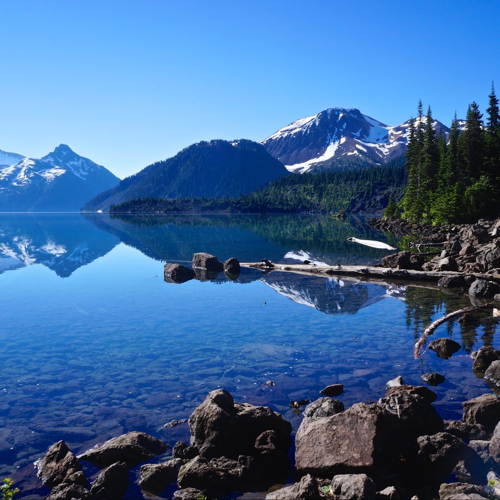
Raven Creek is located on a headland, so you can see it in the distance for most of the paddle. The campsite is located on the north side, so you will have to paddle around the entire headland to get there, but there are lots of places to take a break. Like I said, we were the only people at the campsite. Despite there being tons of spaces to land, there’s not a lot of places to camp because of the tidal influence. If the tide is low, which it was when we arrived, do not assume you can set up anywhere on the beach. Find the high tide line and make sure you set up behind it. Most of the campsites are located in the woods at the back of the beach, but we were able to find one really nice beach site since we were the people there.

Like I said, we had beautiful weather for the entire weekend. It wasn’t super hot because it was still April, but it was sunny the whole time we were out. We set up our tent and ate supper and then spent the rest of the evening on the beach, watching the sunset and then having a campfire. We brought our firewood with us, but there was a lot of dead wood around the beach as well, likely because it was so early in the season.

PSX_20260607_191222
PSX_20260607_190418

We got up early on Saturday to go paddling for the day, because as always, I was worried about the wind. Given how windy it had been on our paddle in, and knowing that we’d have a headwind on the way back to the campsite in the afternoon, I wanted to get most of our paddling done in the morning. We had a simple breakfast and then started paddling north along the shoreline. It was a beautiful day and the water was pretty flat, making for really enjoyable conditions. On a normal day, we probably would have decided to paddle all the way to Osprey Creek and back, but I’ve been battling a knee injury this year that makes it a little more challenging to kayak, so we decided to paddle up to Little Goose Island instead, which ended up being ~12km of paddling.

There’s no private properties along the shoreline until you get to Little Goose Island, but there still isn’t really anywhere to pull out. There’s a small beach before you reach the line of properties in the bay, 4km from Raven Creek, and we decided to stop there for a break. We weren’t sure if there would be somewhere to pull out on Goose Island, but if you go around the back side of the island, there are 2 small little coves where you can get out of the boat. We couldn’t land anywhere, but the water was shallow enough that it was fine. We were also tucked away from the houses in the little cove and we were able to go for a quick swim.

PSX_20260607_190254
PSX_20260607_192954

We could also walk up onto a little headland on the island that had beautiful views of the lake. I wanted to keep paddling further because the water was so calm, but I didn’t want to further injure my knee, so we decided to head back, stopping at the same beach for another break. It was an excellent decision because we got back to Raven Creek almost exactly at 1pm, which was precisely when the wind came up. It got significantly windier in the afternoon, to the point that we could see whitecaps in the middle of the lake, so I was glad that we came back when we did.

We spent the rest of the day relaxing on the beach and it was incredibly enjoyable. A few day users stopped by to hang out for a few hours, but they all disappeared back to their boats by suppertime. The trip was the same weekend that Noah Kahan released his new album, so I spent the entire afternoon listening to it on the beach while drinking iced tea. I’m pretty sure is the exact way Noah intended for an album called The Great Divide to be listened to. Usually we like to go out for a sunset paddle, but again, the wind never really died down again until sunset, so instead we just enjoyed our supper and the solitude, having another campfire as the stars came out.

PSX_20260607_193334
PSX_20260607_193234

We got up early again to paddle out before the wind came up and we had a really nice flat paddle with some kingfishers, who seemed to follow us the entire way back down the lake. The boat launch was much busier than when we left with day users heading over to Widgeon Creek. A lot of people rent boats to go to Widgeon, which I think is fine, but I don’t recommend this for Pitt Lake unless you know what you’re doing. There were a few canoers struggling to cross the Pitt River and we talked to the guys who rent the boats and they said that despite giving detailed instructions, a lot of people still struggle and have had to be rescued on more than one occasion. Crossing the Pitt River is the biggest challenge visiting Widgeon Creek, but the rest of the trip isn’t too challenging. Pitt Lake is a whole different beast with the wind, so I wouldn’t recommend it without prior experience.

But overall, this was a fantastic trip for us. Even though this can be a busy late, I loved the solitude that we got in April. The nice weather definitely made a big difference and I’d be willing to do the trip again. I really liked the campsite and the lake. Getting up to paddle early was probably the best decision that we made. I’d love to go back and explore as far as Osprey Creek, or even to the end of the lake. We got back to the boat launch before 11am and there were two guys launching a double kayak that were planning to go all the way to the end of the lake and back, which I thought was overly ambitious. I think next time, I’ll try to hit Osprey Creek for two nights instead. Either way, I recommend this trip for intermediate paddlers.

20260426_095838

Overnight Hikes for Beginners Near Vancouver

Last week, I shared a Beginner’s Guide to Backpacking for those looking to make the transition from hiking to backpacking. A large part of trip planning is selecting a good trail, especially as a beginner, so I’ve put together a list of trails near Vancouver that I think are appropriate for new backpackers.

There are literally hundreds of trails within a 3-hour drive of Vancouver and it can be difficult to know where to start. My biggest recommendation is to keep it simple by choosing easy trails and campsites with access to basic facilities. It can be an adjustment getting used to carrying a large backpack, so pick shorter trails with less elevation gain, and a first-time trip can be made a lot simpler with access to an outhouse, bear cache, and cooking shelter. See my Guide for more information on how to select and book campsites.

Here are some of my preferred hikes for beginners, in order of level of difficulty (easiest trips first):

3 Brothers Mountain (Buckhorn Campsite)

Region: E.C. Manning Provincial Park
Distance: 4km each way
Elevation: 200m
Reservation: yes ($5pp, per night)
Amenities: outhouse, bear cache, tent pads, cooking shelter, picnic tables
Season: July-September
Drive time from Vancouver: 2.5 hours
Trip Report: found here

Buckhorn Campsite is my pick for best experience for beginners. Manning Park is my favourite park near Vancouver and I think this hike is ideal because it’s short, has a lot of amenities, and is absolutely beautiful. You have to drive up all the way up Blackwall Road to get to the trailhead, so most of the elevation gain is done in the car. You get to enjoy brand new tent pads and a gorgeous cooking shelter, surrounded by alpine wildflowers. The reservation system for this site is new in 2024. This campsite is ideal for 1 or 2 nights and is a great base if you want to day hike to 3 Brothers Mountain on your second day.

Cheakamus Lake

Region: Garibaldi Provincial Park
Distance: 4-7km each way
Elevation: 250m
Reservation: yes ($25pp, per night)
Amenities: outhouse, bear cache
Season: June-October
Drive time from Vancouver: 2 hours
Trip Report: found here

There are two options for Cheakamus Lake, the first campground is called Cheakamus Lake and is located 4km from the parking lot along mostly flat terrain. The second campground is called Singing Creek and is located 7km from the parking lot, and is still mostly flat terrain. Either campground is a great option for a 1 night hike. If you’d like to do 2 nights, camp at Cheakamus Lake and do a day hike to Singing Creek and back on your second day. Be diligent with bear safety on this hike as there is a history of bears in this area.

Viewpoint Beach

Region: Golden Ears Provincial Park
Distance: 4.5km each way
Elevation: 200m
Reservation: yes (new in 2026, $17pp, per night)
Amenities: outhouse, bear cache
Season: May-October
Drive time from Vancouver: 1 hour
Trip Report: found here

Viewpoint Beach was the first place I ever took my girl guides and it’s a great option for beginners. It’s a short and easy walk from the parking lot to the campground and there is an outhouse and a bear cache available. However, because there are no reservations, I recommend to leave earlier in the day to secure a campsite. You can camp on either side of the river, but don’t attempt to cross the river. The bear cache and outhouse are located at Viewpoint Beach. The other side of the river is called Hikers Beach and can be accessed by crossing the large wooden bridge 500m before Viewpoint Beach. You can extend this trip to 2 nights if you’d like to do a day hike up to Alder Flats.

Tetrahedron Park

Region: Tetrahedron Provincial Park
Distance: 3-6km each way
Elevation: 250m
Reservation: yes ($15pp, per night, paid to the Tet Outdoor Club)
Amenities: sleeping hut, outhouse
Season: June-October
Drive time from Vancouver: 1 hour + ferry
Trip Report: found here

Tetrahedron Park is a really unique experience and is a great option if you don’t have a tent yet. Tenting is not allowed in this park and all users must stay in one of the huts. There are 4 huts, but I recommend either Bachelor Cabin or Edwards Cabin for beginners (though Bachelor Cabin is often used by families, so please be respectful of children). These sites are managed by the Tetrahedron Outdoor Club. First, join the Tetrahedron Outdoor group on facebook and do a search for your dates to see how many other people are already going then (the cabin sleeps ~12), then post your booking on facebook and pay on the website. This location is great for multi-day trips, as you can do a day hike up to Mount Steele from Edwards Cabin, but the mountain may have snow until July.

Lindeman Lake

Region: Chilliwack Provincial Park
Distance: 1.5km each way
Elevation: 225m
Reservation: no (permit is $5pp, per night)
Amenities: outhouse, bear cache, tent pads
Season: May-October
Drive time from Vancouver: 2 hours
Trip Report: found here

Lindeman Lake is a very popular trail, so if you opt to camp here, I recommend going very early or visiting on a week day. There are a small amount of tent pads and room for tents, but it can get very crowded. It’s an attractive hike because it is very short, but there is significant elevation gain over a short distance, so be prepared for a steep hike. Sites are not reservable, but you do need a backcountry permit, which can be obtained 2 weeks before your trip. This is a great option for a two night trip if you want to do a day hike up to Greendrop Lake, but you may encounter snow past Lindeman Lake until July.


In my opinion, the first 5 hikes on this list are the most ideal for true beginners planning their first ever overnight hike. They are shorter and have less elevation gain. The rest of the hikes on the list are starting to get more advanced in that they are longer and have more elevation gain, but are still good options for newer backpackers and second trips. I recommend these trips to people who are are already experienced hikers; those new to both hiking and backpacking should stick with the hikes listed above.

Joffre Lakes

Region: Joffre Lakes Provincial Park
Distance: 5.5km each way
Elevation: 400m
Reservation: yes ($25pp, per night)
Amenities: outhouse, bear cache
Season: July-September
Drive time from Vancouver: 3 hours
Trip Report: found here

Joffre Lakes is another insanely popular hike and you will have to be diligent in booking exactly 4 months ahead of your planned dates to secure a permit. However, it’s popular for a reason and is actually a relatively straightforward trip for the incredible views. Be prepared for a climb, but it’s not too steep, so it just requires a little bit more effort for a great reward.

Fairview Loop Trail

Region: Upper Sunshine Coast
Distance: 6-12km (customizable)
Elevation: 250-400m
Reservation: no (recommend a donation to qPAWS)
Amenities: sleeping hut, outhouse, bear cache, picnic tables
Season: May-October
Drive time from Vancouver: 2 hours + 2 ferries
Trip Report: found here

We’re definitely starting to get a little more technical with this trail. The Fairview/Rainy Day loop is located in Saltery Bay, directly after you get off the ferry. To save money, park at Earl’s Cove and walk on the ferry as you don’t need your car on the other side. This loop trail is part of the Sunshine Coast Trail and has two huts on it, Fairview Hut and Rainy Day Lake Hut. It’s 6km (250m gain) to Fairview hut (counterclockwise) and 4km (350m gain) to Rainy Day Lake hut along the road (road is recommended as it’s significantly longer and steeper to take the trail). You can do the trail as a loop to visit both huts (12km total), but this is a more challenging option as there’s 700m of climbing to do both huts. The huts can get very busy, so you should bring a tent in case they get full.

Elfin Lakes

Region: Garibaldi Provincial Park
Distance: 11km each way
Elevation: 600m
Reservation: yes ($25pp, per night)
Amenities: sleeping hut, tent pads, outhouse, cooking shelter, bear cache, picnic tables
Season: July-September
Drive time from Vancouver: 1.5 hours
Trip Report: found here

Elfin Lakes is the longest trail on the list, so you should be prepared for ~4 hours of hiking with your backpack. However, I include it because the elevation gain is spread out over the distance, so it’s never too steep and it’s a very wide and easy trail. This is another hike that books up fast, but you can stay either on a tent pad or in the hut, but they have separate bookings, so make sure you book the correct one. The views from the campsite are some of the best of any hike. Watch out for bears on this hike, especially in the Fall.

Garibaldi Lake

Region: Garibaldi Provincial Park
Distance: 9km each way
Elevation: 800m
Reservation: yes ($25pp, per night)
Amenities: outhouse, bear cache, cooking shelters, picnic tables
Season: July-September
Drive time from Vancouver: 2 hours
Trip Report: found here

This is the final hike on the list. It has the most elevation gain and you should be prepared for 3 hours of hiking up switchbacks in the first 7km. The trail is not technical, but it is very boring until you reach the lake. However, if you like amenities, it’s a great option. You can camp at either Garibaldi Lake or Taylor Meadows, which have composting toilets, cooking shelters, and picnic tables. I recommend this trip only for those who are already experienced hikers.


There are 3 more trails I want to note because they are easy trails, but I didn’t include them in my main list because they don’t have outhouses or bear caches. There are enough other challenges to contend with on your first hike, so I don’t recommend these. But once you get comfortable with digging a cathole and making your own bear caches, these are good options. However, please note, these are all on crown land, so while there’s no permit required, the sites also don’t receive any maintenance, so please respect the natural environment, leave no trace and pack out everything, including your toilet paper!

Falls Lake – a 1.5km hike on the Coquihalla Summit Rec Area. It’s totally flat and is a great option for a beginner snow camp as well.

Levette/Hut Lake – you can drive up to Levette Lake (which can get very busy), and it’s only another 4km to Hut Lake, which doesn’t get many visitors.

Semaphore Lakes – a 2.5km hike, but this one is a bit steeper (300m gain). There are limited trees for a bear cache here, so a bear canister is recommended.

If you’re looking for more advanced trips, check out my posts on Thru Hikes and Loop Hikes.

8 Great Spring Hikes in the Lower Mainland

Growing up in Newfoundland, I never really liked Spring because it’s barely a season there (pretty sure we just get a second winter). But Spring in the Lower Mainland is fantastic! It actually warms up when it’s supposed to and pretty much the entire city has been in bloom this April. But as much as I love it, it also kills me a little bit because even though it warms up so much in the city, it still takes a long time for all the snow in the mountains to melt. Proper hiking season doesn’t really start until late June, early July, but there are lots of lower elevation hikes that you can do in the Spring that are located right in our backyard! Here’s a few of my favourite Spring hikes to tide you over to those warmer summer days:

Baden Powell Trail

The Baden Powell Trail is a whopping 42km long trail that runs all the way from Deep Cove to Horseshoe Bay. But don’t be intimidated by the length, the entire trail can be done in a series of day hikes, they’re just best done with two cars (one at the start and one at the end) so that you don’t have to backtrack. The four main trail sections include Deep Cove to Lynn Canyon, Lynn Canyon to Grouse Mountain base or Cleveland Dam, Cleveland Dam to Cypress parking lot, and Cypress to Horseshoe Bay. I’ll admit that I’ve only actually done the Deep Cove to Lynn Canyon section, but I’m hoping to hike a few more sections! I believe the more popular sections are between Deep Cove and Grouse, because there is significant elevation gain between the Cypress Mountain sections. Either way, there’s a lot to explore on this forested trail! Fun fact, the trail is named after Lord and Lady Baden-Powell, the founders of Girl Guides and Boy Scouts!

Big Cedar and Kennedy Falls Trail

This is a great trail located in North Vancouver that hikes through the forest to 2 main attractions, a really big cedar tree and Kennedy Falls. The hike is 10km long, with approximately 150 metres in elevation gain. We thought it would be a pretty quick hike with such limited elevation gain, but there is a lot of up and down through the woods, so the cumulative elevation gain is greater. It’s also a more technical trail than I was expecting, so if you’re looking for an easy walk in the woods, this isn’t the one for you. However, if you’re looking to warm up those legs in preparation for the summer hiking season, this is the perfect hike! There is a lot of spray coming off Kennedy Falls with the Spring run-off, so bring a rain jacket if you want to get close for photos. The trail is dog friendly, but small dogs might struggle with all the trees and roots across the trail.

Jug Island Trail

If you don’t want to travel to the North Shore, there’s some great hikes available in Belcarra Regional Park, located just past Anmore. Jug Island Trail is one of my personal favourites because it’s a short hike, but a good warm up. It’s only 5.5km long and has about 100 metres in elevation gain (it’s listed as having none, but that’s because it starts and ends at sea level). It’s a mostly forested hike, but there is a nice view about midway through the trail looking down at the backside of the peninsula, as well as a beautiful view of Jug Island and Indian Arm at the end of the trail. The beach at the end of the trail is also accessible by kayak from Deep Cove or Cates Park if you’re up for a boating adventure! This is the only trail I’ve done, but there are other short trails in the area such as Admiralty Point and Sasamat Lake.

Lower Seymour Conservation Reserve

The Lower Seymour Conservation Reserve is located between Grouse and Seymour and protects the ecosystem running up towards Seymour Lake, one of Metro Vancouver’s 3 water supply lakes. I worked in this area for about 8 months, so I had lots of time to explore some of the trails and there’s a ton of options to choose from! They’re all pretty similar in that they’re mostly forested trails (common theme for Spring hikes as it’s too early to get up in the mountains). Parking is available just off the end of Lillooet Road at the Rice Lake Gate, at the Lynn Canyon Ecology Centre, or off of Rice Lake Road at the entrance to Lynn Headwaters Regional Park. I’d personally recommend avoiding the Ecology Centre as it draws a lot of tourists for the suspension bridge, it’s only about 1km hike to the bridge from the other entrances if you still want to visit. Some of my preferred trails include Fisherman’s Trail (13km), which hikes up to a viewpoint overlooking the River, and Rice Lake (3km), which is great for fishing (if you’re into that). I also like the Lynn Headwaters Trail (6km), which follows Lynn Creek and can be extended to hike to Norvan Falls (14km). The falls are definitely best explored in the Spring when run-off is high, by Fall, the falls are just a trickle!

Lighthouse Park

I know, I know, all the locals are already super familiar with Lighthouse Park, but as an East Coaster I only visited the park for the first time last year! This is the place to go if you’re after ocean views! There’s still a ton of forested trails here, but they pop in and out of the woods along the coastline. I think of Lighthouse Park as a bit of a build-your-own-adventure trail because there’s tons of trails running through the park and you can pick which circuit you want to do. When I visited, we mostly followed the coastline, making a bit of a loop from the parking lot. There’s limited elevation gain in this park, but lots of great views!

Golden Ears Park

I’m a huge fan of Golden Ears Park. It gets crazy busy in the summer though, which is why Spring is great time to visit! Don’t even think about doing Golden Ears Peak, it’s way too early for that, but there are some nice trails located at the back of the park. Drive to the far end of Alouette Lake and park in the North Beach Campground lot (do not actually go into the campground, parking is not permitted there). There’s two trails, the Lower Falls Trail and the East Canyon Trail to Viewpoint Beach. At 5.5km, the Falls Trails is really more of a walk, but affords some nice views of the mountains from the river and a nice waterfall at the end of the trail. The trail to Viewpoint Beach is a little longer at 8km, and has a great view looking up at the mountains from the beach at the end. There’s about 200m elevation gain on the viewpoint beach trail and none on the falls trail. On maps, it looks like you can connect between these two trails, but I’ve done these hikes several times and I’ve never been able to find where the two connect.

Capilano Regional Park

This is another park I’ve explored as part of my work and it is a great urban trail in North Vancouver. If you’re feeling ambitious, you can hike all the way from Ambleside Park up to Cleveland Dam (~14km), but you can also access the trail from Cleveland Dam or from some of the local roads on the West side of the Park. The engineer in me loves Cleveland Dam and there’s a great view of the Lions looking out over Capilano Lake (another one of Metro Vancouver’s drinking water supply lakes). You can drive right up to the lake, but I’d recommend starting somewhere lower on the trail and making the dam and lake your lunch break in the middle of the hike. I like this trail because there’s tons of neat bridges to cross over with great views of the Capilano River and canyon. You can also stop in and visit the fish hatchery along the way!

Burnaby Mountain and Barnett Trail

There’s tons of great Spring trails located around Burnaby Mountain and it’s easy to take transit to them! I’ve personally done the Burnaby Mountain Summit Trail, which loops around the top of the mountain, and the Barnett Trail, which loops around the back of the mountain. The best views are probably from Burnaby Mountain Park. Both of the trails overlap each other and I would definitely consider them urban trails as they loop in around the SFU campus and the bike park, but there are a few views looking down over Indian Arm and you do get a nice workout climbing back up the mountain. Both hikes are under 10km.