Hiking Chain Lakes Trail

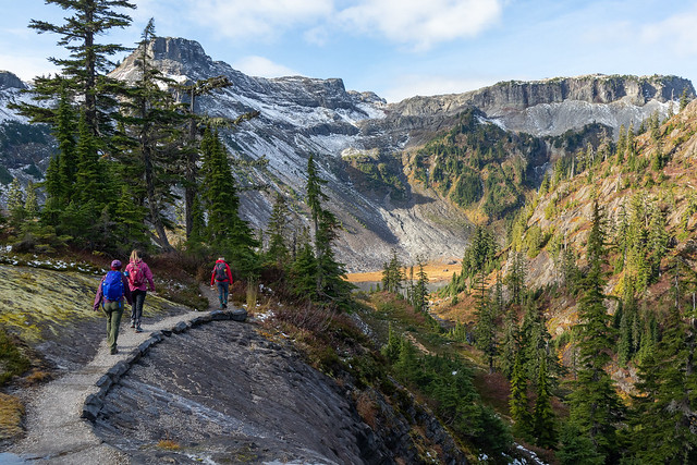
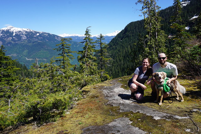
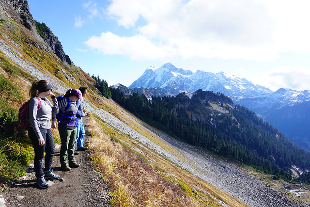
The final trail in my little ‘Fall hiking in Washington’ series is the Chain Lakes Trail that leaves from the ski area at Mount Baker. Me, Lien, and Emily had visited the previous year in March to snowshoe Artist Point and were totally awed by the views, so we decided to come back in the fall for a different view. It was Thanksgiving Weekend in October 2019, just one week after me and Lien had hiked Yellow Aster Butte. This time we were joined by Emily and my friend Amy, who flits in and out of my life every now any then. We never really know when she’s going to appear and disappear again, but it’s fun to hike with her!

DSC00810

We had Thanksgiving dinner at my house on Sunday night and then made an early departure on Monday morning to cross the border. Traditionally, me and Brandon have always gone on a Thanksgiving Monday hike (3 years running), but this year he went on holiday and bailed on me, so I had to console myself with my other companions. I really liked both Yellow Aster Butte and Chain Lakes, but of the two, I would definitely have to give the edge to Chain Lakes. At 11.5km, it has half the elevation gain of Yellow Aster Butte, just 375m. The trail starts in the backcountry parking lot at the ski hill. Be sure to get and print out the parking pass online before you go because there’s no where to get it on the mountain. It’s only $5 and I’m told you can get it at the visitor center at the bottom before you drive up, but I’ve never once seen it open on the weekend.

DSC00839

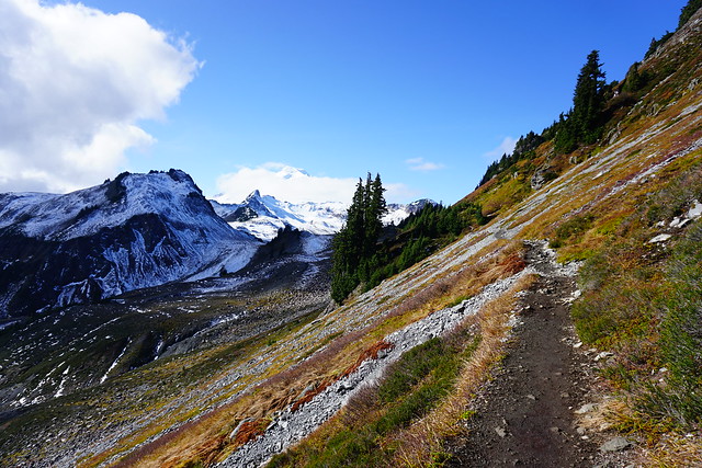
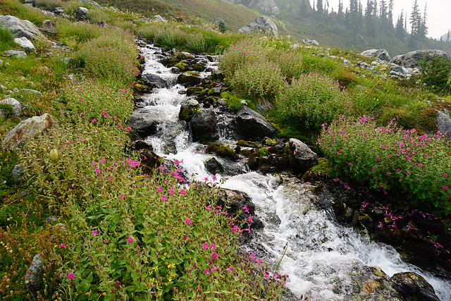
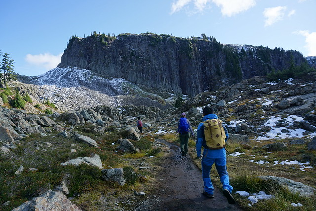
Chain Lakes is one of those rare trails that is scenic the ENTIRE trail. You’ve already driven up most of the elevation gain to get to the ski hill and from there, the trail continues up to the summer parking lot for Artist Point. In the summer, you can drive almost the whole way up to Artist Point, but at some point in September they close the road. Hiking up the road is the least scenic part of the trail, but still has really nice views looking down into the big bowl that’s popular among backcountry skiers. We decided to skip the Artist Point viewpoint since we’d already done it and instead continued down the other side of the parking lot into the backcountry. I think it’s a bit of an understated part of the trail, but it was one of my favourite parts. You hike right across the slope of Table Mountain, looking out towards Mount Baker.

DSC00840

From the Skyline Divide Trail, I felt like I was so close to Mount Baker that if I continued hiking I would eventually reach it (you can reach the foothills, but then the trail ends). But from the Chain Lakes Trail, you really are on the trail that goes up to the top of Mount Baker (albeit this is only for experienced mountaineers). It looked like if we just crested a few more hills we’d pretty much be there, but of course, it’s further then it looks as the size of the mountain dwarfs everything surrounding it and can be a bit misleading. Once you get to the end of Table Mountain, the trail turns to continue around the mountain and over to the chain lakes part of the trail. You can also hike along the top of Table Mountain, which may have to be an adventure for another day.

DSC00909

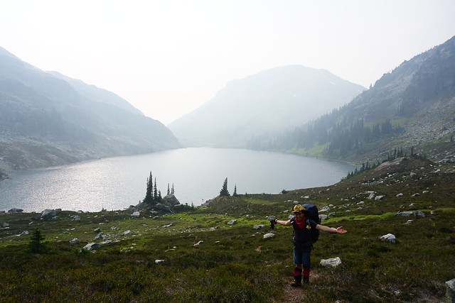
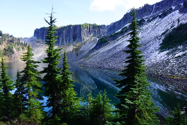
The first lake you come to is Mazama Lake. You can camp there, but it’s pretty small and not the most scenic, so if you’re overnighting, I’d recommend one of the other lakes instead. After Mazama, you come to Iceberg lake, which is the biggest and has staggering views looking up at the steep cliffs that surround the lake. This is where we decided to stop for lunch and enjoy the views before starting our climb back up the pass to the top of the trail.

DSC00879

One of the awesome things about Chain Lakes, in addition to the fact that the entire hike is scenic, is that it’s a loop trail, so you don’t have to do any return on the trail. It starts to climb around Iceberg Lake until you reach Haynes Lake, which is where I’d recommend branching off to camp. From there it gets really steep. There’s some great views looking back down the trail at Iceberg lake and you continue climbing to the top of the pass before starting to descend back into the bowl we were looking at from the start of the trail. It seemed like most people were doing the trail in the opposite direction as us, starting with the steep climb up the bowl. I’d recommend going the same way as us though because then you get to finish the hike with what was, in my opinion, the best view.

DSC00922

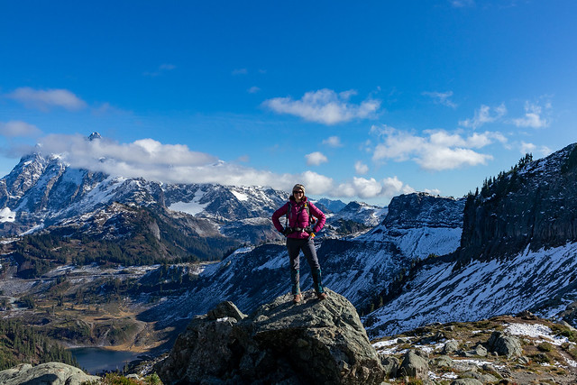
The view from the top of the pass is really unreal. The mountains stretch out around you in every direction and as you climb up the side of the Mazama dome, you really feel like you’re on top of the world. We’d already had lunch, but we decided to stop and have a break to make tea so that we could enjoy the view for a little bit longer! Even though we still had a few kilometers left to go, from the top we could pretty much see the trail down to the bottom almost the whole way there. We continued from the pass and started the long descent down the bowl to the parking lot. We were basically undoing all of the elevation from the rest of the hike in this stretch, which is why I recommend doing the hike from the other direction, that way the ascent is more gradual, with a few flat parts in between as you climb up. The descent down the bowl though is hard on the knees, so something to take into consideration as well.

IMG_4567

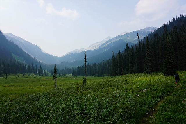
The trail switchbacks for a while until you finally reach the bottom. It weaves through the valley and you pass by a few more lakes and the most quaint little rock bridge. Seriously, there’s no part of this trail that is not scenic, and even a few minutes before the parking lot, we were still stopping to take pictures of things. Except for Emily, who was badly in need of a washroom and sprinted the last 15 minutes of the trail to get to the outhouse.

IMG_4564

Sadly that was our last adventure in the North Cascades. I returned the following winter with Carolyn and Brandon to snow camp on Artist Point, but unfortunately with Covid, we haven’t been able to return. I was hoping to do a few hikes in the summer and fall again, but sadly I’ll just have to wait until next year (hopefully). Either way, if you’re from Washington, I’d definitely recommend hitting up the North Cascades, and if you’re Canadian, put in on your bucket list!

IMG_4406
IMG_4534

Hiking Crooked Falls and Sigurd Creek

It’s that awkward time of year when there’s still a lot of snow in the mountains, but we’ve finally reached the time when lower elevation hikes are becoming accessible again! I always play it really safe in the Spring because there are a lot of hazards that accompany the snow melting, but Brandon, Seth, and I went out the last week of May to do some exploring outside of Squamish.

Last Fall Brandon and I hiked High Falls Creek, which was my first time exploring in this area. We did some driving around to see what else was out there and added the Crooked Falls hike to our list – May seemed like the perfect time! Crooked Falls is located on the Sigurd Trail, which is accessible by 2WD and is just across the Squamish River when you pass the rec site.

20210529_161902

It was really busy when we arrived around 10am, but a lot of the traffic appeared to be people camping and fishing on the river. We didn’t actually pass that many people on the way up to Crooked Falls. The hike starts out on an old forestry road that heads up into the woods. It meanders around the side of the mountain before seemingly heading straight up it. It’s only 3km to Crooked Falls and 500m of elevation gain, so it’s definitely steep!

DSC08930

We took Sadie with us on this trip, which was a bit of a challenge because she’s not friendly with other dogs. She did well passing other people, but the trail is pretty narrow and everyone lets their dogs off leash, so we had to pull her into the woods whenever we would encounter another dog to try and avoid a reaction. Overall, it only happened a few times and she mostly was able to handle herself, but she did have one bad reaction to a dog that ran up in her face because it was off-leash. It’s a pet peeve for me – I have no problem with off-leash dogs (we do let Sadie off leash when there’s no one around and it’s permitted), I just wish people would ask consent before letting their dog approach you.

DSC08926

Anyways, back to the trail. Like I said, for the most part we didn’t encounter many people. After 3km there’s a branch off the left side of the trail that heads in towards Crooked Falls. Spring is a great time to visit because the falls are giant with all the run-off. There’s two small viewpoints and you do get a lot of spray off the water (as you can see in the photo), so I wore my rain coat while taking photos. We had a our lunch in the woods where we could stay dry, but still see the falls, before heading back to the main trail. Several other hiking groups came into the falls after us, so it did look like it was getting busier.

PSX_20210603_112800

It was only shortly after noon, so we decided to continue up the trail to Sigurd Creek. My guidebook indicated that hiking another 1.5km would take you to a lookout off the Sigurd Trail. While the falls are reasonably popular, we spent 3 hours on the Sigurd Trail and only saw 1 other person the whole time. It’s not the most well maintained trail and it’s steep and muddy, so I don’t really blame people.

Shortly after you leave the junction from Crooked Falls, there’s a steep 100m side trail that goes up into the woods to a viewpoint. We decided to save it for the way back, but it wasn’t the best viewpoint. It’s a bit crowded in by trees, but you can see the river down below. We continued on the trail until we came to a second junction. To the left is the Sigurd Trail to Ossa and Pelion Mountain, to the right is the Rose Trail to Sigurd Peak. My guide book pre-dated the Rose Trail, so I was a little bit confused where to go at first, but Brandon figured out that what we wanted was to follow Sigurd Creek on the Sigurd Trail and we continued that way.

20210529_130856

Unfortunately our distance tracking was a bit off because the guide book doesn’t include the Crooked Falls side trail, so after 1.5km of hiking we hadn’t reached anything that looked like a viewpoint. We did however stumble upon a second waterfall cascading down from Sigurd Creek. It was lovely and this time we had it all to ourselves, so we had a quick break and Seth refilled his water bladder. Sadie had chilled out a lot and was having the time of her time exploring around the woods.

We decided to push on a little further, but after the waterfall the trail becomes extremely steep and it was slow going. It’s another 400m in elevation gain between Crooked Falls and the viewpoint (on top of the 500m you’ve already done), so it’s definitely no walk in the park. The viewpoint indicated in my guidebook wasn’t shown on my GPS, but I made a guess about where it would be based on the topography. From the trail it really didn’t look like we were close, so Seth was ready to turn around because we were all tired from the uphill. But I persuaded him to push for another 10 minutes to the point on my GPS, because we were really close and I was convinced it was the viewpoint.

DSC08998

Fortunately I was right and a few minutes later we finally crested the mountain and could see a small knoll branching off the trail with a bare top. We climbed up to it and then collapsed while enjoying the view. We stayed up there about half an hour, snacking and guessing what mountains we were looking out at. We could see up the snowy side of Pelion Mountain and out to Cloudburst Mountain. Behind that we could see Black Tusk from a new angle and could see most of Mount Garibaldi peaking around the corner.

DSC08977

It was hot at the summit, so we gulped down lots of water and Brandon shared macarons for a summit snack. Sadie had her summit snack at the waterfall, so we gave her half of her emergency meal to give her a boost after so much climbing. She wasn’t showing any signs of being tired though and was still bounding along the trails when we started to make our way back down again.

Once we got close to the junction again, we heard a lot of people at the falls, so I guess it does still get pretty busy during the day. There were still a few groups of people making their way up, but it was 4pm, so most people were on the way down. Because of the topography, you’re on the back of the mountain, so we lost the sun around 4pm and it was surprisingly dark along the trail, even though the sun doesn’t set until like 9:30pm. Sadie was finally starting to look a little tired and nothing seemed to bother her on the way down.

20210529_165226

All together we ended up hiking about 12km. My book has Sigurd Creek round trip listed as a 9km hike, so it is a bit off. Like I said, I don’t think it accounts for the 300m branch to Crooked Falls, but even so, it’s definitely closer to 10 or 11km round trip and has a whopping 900m of elevation gain in total. So be prepared if you attempt this trail. We had a great time, but we ended up being on the trail for 7 hours and had been anticipating it would be more like 5 hours. Overall this is a great area and I’ve had a lot of fun exploring there over the last year.

Ring Lake Backpacking Trip

Ring Lake was definitely one of the weirder backpacking trips I’ve been on over the years, but I look back on it now with very fond memories. It was August 2018, the smokiest summer I’ve ever experienced in the lower mainland. My Howe Sound Crest trip had been cancelled for the second year running because of the smoke, but I still wanted to go out exploring somewhere, so Brandon and I decided to head up towards Whistler in hopes that the smoke would thin.

If anything it was worse in Whistler, but we carried on towards Callaghan Lake, pulling over just before the lake at the Conflict Lake/Ring Lake trailhead. Callaghan is most well known for its cross country skiing, but you can explore there in the summer as well. It’s a gravel road that’s in pretty rough shape; I think it’s doable in a 2WD because there aren’t many water bars, but high clearance definitely make it easier.

DSC06704

The Conflict Lake trail is really popular in the winter because there’s a beautiful cabin you can ski into and explore the area from, but for some reason it’s not operating in the summer and we didn’t see a single person on the trail. It’s 5km to Conflict Lake along relatively flat terrain through the woods. I had a bit of an upset tummy, so we rushed along to the Lake, thinking there would be an outhouse near the cabin. But alas, it’s too swanky a cabin for that so I was forced to make use of my trowel.

DSC06631 (2)

We had lunch at the lake before carrying on to Ring Lake, which is another 5km, but this time it’s all uphill. It’s about 500 metres in elevation gain, but since it was flat to Conflict Lake, all the elevation is in the second half of the trail. However, right after Conflict Lake there are some really beautiful meadows, and just our luck they were filled with wildflowers! The contrast of the green meadows and smoke filled valley made me feel like I was somewhere else entirely. Coupled with the fact that we had yet to see another soul on the trail, it was quite blissful.

DSC06622

It’s a tiring climb up from there though. The trail skirts the edge of the valley as you climb up towards the lake. It’s almost totally in the trees until you reach the top and pop out in the alpine. When I did Brew Lake it reminded me a lot of Ring Lake because both trails are almost completely forested until you reach the top, and both weirdly empty.

The challenge of Ring Lake is that about halfway between Conflict and Ring, you have to do a pretty dicey river crossing. Because of the terrain, the river cascades down over the rocks at a pretty steep angle, making it dangerous if you were to misstep and fall in. For this reason, the season during which you can hike to Ring Lake is short because you need to wait until the flows in the river goes down. I had a friend that tried to go in July once and had to turn around at the river crossing, so I’d really only recommend going in August. Fortunately for us (I guess), it was a super dry year, so we didn’t have too much trouble. I just opted to wear my full goretex boots for the trip and brought two hiking poles instead of the one I normally bring to make the crossing easier (although I ended up giving the second one to Brandon).

HOP_0198

After the crossing the trail is still quite technical though, there are a few ladder and rope sections, but eventually you pop out of the trees to the most gorgeous mountain vista! Sadly though, with the smoke we could barely see across the lake, but the whole area is hemmed in by mountains and it looked like there was lots to explore nearby. When we arrived we saw one tent on the far side of the lake, so we went in the other direction to set up our camp. It’s a large lake, so by the time we found a place we liked, we couldn’t even see them anymore. They left before us the following morning and we didn’t see a single other person the whole weekend.

DSC06638

There’s only a handful of times when we’ve had such solitude at a campsite. I love it, but it does make you much more keenly aware of your presence in the wilderness. Ring Lake is in grizzly bear country, so caching our food was super important. Unfortunately though, it’s also an alpine environment and trees were very sparse. There are some around, but they’re the kind that go straight up with very few branches from which to hang a bear cache. After pitching the tent, we immediately got to work on our bear cache because we knew it would take some time. Looking back, I really have no idea how we managed to get the thing up – it took us about an hour, but somehow Cowboy Brandon managed to lasso to trees and we created a clothesline between them that we then hoisted our bags up. Most challenging was making sure not to tie the ropes in such a way that we wouldn’t be able to get them back, but in the end it all worked out. Definitely the most impressive bear cache I’ve ever fashioned. It was higher than it looks in the photo (because it was taken on a slope), but it did start to sag overnight.

20180819_080600

I’d also brought some bear bangers in case we saw a grizzly and I’d been thinking of setting one off before bed just to make sure the area was clear, but there is a small chance of fire with bangers and flares, so I opted not to with the forest so dry. Instead we just kept our bear horns nearby and we ended up sleeping with the fly off the tent, so we could easily see the surrounding area with the moonlight. I’m not really sure why we left the fly off, I think Brandon wanted to watch the stars, but with so much smoke, there wasn’t really much to see overnight. We did get a beautiful orange sunset over the lake though!

DSC06650

I think what makes this trip stick out in my mind so much was the rest of the evening. After we’d set up camp, we went downwind of our tent to make dinner. Brandon had brought his speaker so that we could play music to scare off the bears and we’d accidentally brought a pretty significant amount of fireball with us. So we ended up doing quite a few shots and having our own mountain dance party as we made dinner! There’s nothing so enjoyable as a watching the sun go down with Brandon’s backcountry thai chicken curry and a pleasant buzz. But mostly we just marveled in our good fortune in having such a beautiful place all to ourselves.

DSC06674

We both regret that we couldn’t explore the area further. There are lots of surrounding mountain peaks that would have made for a fun second day, but the smoke stole any hope of a view, so we decided to just head back down the following day, though we’re both keen to return again in the future.

The trek down was a lot more enjoyable than the hike up. We did a small bit of exploring at the meadows at the top before heading back to Conflict Lake for lunch again. There’s a boulder field between Ring and Conflict Lake that is an excellent place to watch for marmots. We saw a few on the way up hanging out on the rocks. Then on the way back down I counted a record 7 marmots out sunning themselves! One was a family of 4 with two little pups that were super cute!

DSC06724

It’s only 10km each way, but it feels like a long 10km with big hiking packs. The hike from Conflict back to the car felt like it went on forever and we were relieved when we finally arrived back at the car and could shed our packs and smelly clothes. Like I said, I really would like to go back and visit Ring Lake again, but I would never do it in such conditions. Looking back, the smoke was great enough that we shouldn’t have gone hiking at all and I’m impressed I didn’t feel sick from it.

We had some really bad smoke in Sept. 2020 as well and again attempted to escape it by heading out of the city. We weren’t successful in escaping it, but on this occasion it gave me such a headache I quit the hike 3km in and went back to the car. When the smoke is so bad, it’s really not worth going out in it since it’s quite dangerous to your health. At the time though, we’d been cooped up for the better part of a month and were going a little stir crazy. It’s a difficult hike, don’t underestimate it – but in different conditions, I would gladly return!

HOP_0387
HOP_0324
DSC06633
DSC06655