Poland Lake Snow Camping

One of my favourite activities every winter is to go snow camping! Carolyn and I have been going for 5 years running and the trip has expanded to include Brandon and Steve. Every year we plan where we want to go and then always end up having to change plans at the last minute. You have to be flexible when going into avalanche terrain and every year it seems that the avalanche bulletin likes to mess up our trip plan at the last minute. We have a very low tolerance for risk in the winter, so we’re always changing location to ensure the safest trip possible.

DSC00172_1

This year we’d been planning to go to Pump Peak (on Seymour), but Vancouver had a particularly warm spell of weather the week before the trip, so we decided to switch to Manning Park instead in hopes of finding fresh powder. It was also calling for beautiful sunny weather on the weekend we went, so we decided on Fat Dog trail in Manning Park, which is supposed to have nice views of the park above the treeline. Then Avalanche Canada issued a special warning a few days before the trip about how the backcountry was experiencing spring-like conditions due to thaw, which meant higher risk, so we decided to change our plans once more.

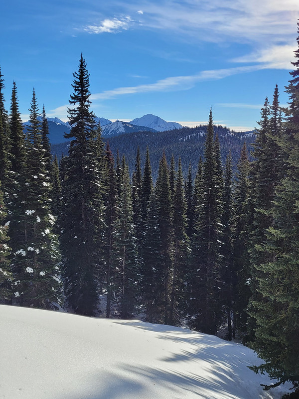
I don’t think Fat Dog is a particularly high risk trail, but you do pass through a valley that is in the run-out zone of avalanche terrain at the start of the hike, so we decided to do Poland Lake instead, which we read didn’t have avalanche terrain and is shown as simple terrain on Avalanche Canada. Poland Lake has been on our radar for years, but for some reason we thought it wasn’t a very nice trail and always considered in a back-up trail.

20220123_124106

We’re so glad we went to Poland Lake, because we ended up loving this location! To access Poland Lake, you have to drive almost to the end of the resort road and park at Strawberry Flats. You can save about 2kms if you hike directly from the ski resort, but there’s no overnight parking at the resort, so if you’re camping, you need to leave from Strawberry Flats. The trailhead is on the north side of the road near the end of the lot where the cross country ski trail starts back towards the lodge. There’s an off-shoot trail that heads up towards the ski resort, running parallel the road. This is the route we took, but we regretted it because it is all uphill and adds 2km’s of hiking. If we did it again, we would plan to leave our bags at the resort and just walk up the road.

20220122_134525

If you do the trail right, you’ll eventually reach a small fork in the trail where the left branch heads back down towards the road and the right branch heads up to the mid-point of the ski hill. In the summer, you can reach Poland Lake via the middle of the hill, but this route is not practical in the winter. You’re supposed to go back down to the bottom of the ski hill and hike up along the western edge of the large green run called Horseshoe. But there was no signage on the left fork and nothing shown on our GPS apps, so we continued along the summer route unknowingly. This was definitely our error, we should have read more about the trail description instead of relying just on GPS, so I caution you here to go back and start from the resort base. In our defense, the resort route is not marked at all and does not look like a proper trail, so we gave resort staff some feedback.

20220122_163817

In any case, we continued up to the midpoint of the ski resort and ended up having to snowshoe ski runs across the entire mountain. This is definitely dangerous as the runs are not wide or intended for snowshoers. Our only saving grace was that the slopes were extremely empty and we didn’t encounter many skiers. Eventually we got off the ski runs and ended up in some of the glades. We didn’t encounter any more skiers, but it was very steep terrain and had we not been in the middle of a resort (where avalanche risk is managed), we would have turned around. There’s no signage because it’s not a winter route, so we relied entirely on our GPS and way-finding to get back on the trail. Eventually we tracked down the official entrance to the Poland Lake trail (which is at the top back of the ski hill) and saw tracks leading in from the other side of the resort, which is clearly where we were supposed to come up.

IMG-20220123-WA0032

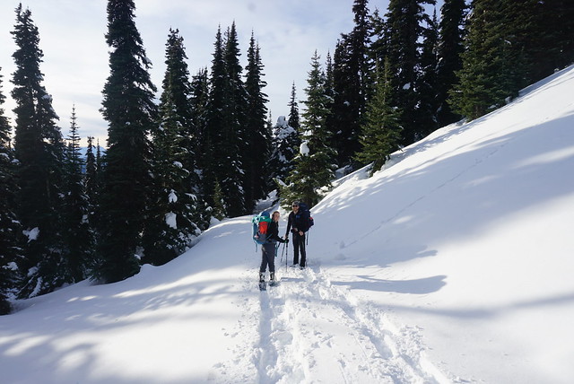
By this point we were really tired from so much uphill travel and worry about where the trail was, but happy to finally be on a proper snowshoe trail. We’d already hiked about 4kms and it’s another 4kms to the lake, but fortunately the trail is a lot flatter along this section. There’s lots of ups and downs, but they are very gradual. It still took us a long time though because we were very tired and by the time we reached the lake, it had taken us just under 5 hours to go 8km. One of the other contributing factors to our pace was that we ended up having to break the trail for the better part of 3 kilometres! We were sharing the trail up until shortly after the 1km mark, but then the tracks abruptly stopped and we had to create the trail to the lake. This is such a rare occurrence in BC, where the trails are always busy, so we were excited to snowshoe in fresh powder and the prospect of having the lake all to ourselves. It is a lot more work to break trail though, so it did slow us down.

20220122_161802

We’re still new to avalanche terrain, but we were surprised while hiking along the Poland Lake trail that it was said not to have avalanche terrain. It is marked on Avalanche Canada as simple terrain, but it is below some challenging terrain and we thought the trail could easily be in the run-out zone of an avalanche along some sections. Fortunately we all had avalanche gear, so we crossed some of the more sketchy looking sections solo to minimize our risk, mostly around the mid section of the trail, south of Grassy Mountain.

PSX_20220123_192802

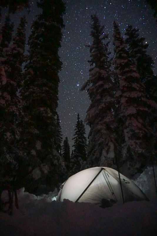
The sun was starting to set when we finally reached Poland Lake and we quickly got to work setting up camp. The official campsite is on the far side of the lake and there is a small emergency shelter over there. Due to imminent sunset, we opted not to go around the lake and found a nice spot to set up camp with a view of the sun setting over the lake. I’m not sure if we’re just getting more experienced, or if it was just that the snow was super light and fluffy and easy to shovel, but we were particularly quick in digging holes for our tents on this trip and it didn’t take us too long to get shelter up. We broke our headlamps out just as we were finishing setting up the tent, so fortunately we had daylight for most of it.

20220122_194254
Unfortunately, we never took the time to build a proper snow kitchen on this trip. Once we got our beds set up it was dark and we were too tired to put in the effort. But we did have a delicious dinner! Brandon made us all miso soup and then me and Brandon had peanut soup and Carolyn and Steve had chicken soup. I tried something new and made bannock for dessert! It makes for a good backcountry bread because there’s no yeast, you just need to bring a bit of oil for frying. Honestly, it was delicious – I had practiced it at home, but it tasted way better in the backcountry. I just added the water right into the bag with the mix and kneaded it in the ziploc, so it didn’t even make any mess!
PSX_20220123_193354

It had been a bit hit and miss with the sun all day, with it flitting in and out between the clouds, but in the evening all the clouds moved off and we had a completely clear night for stargazing! I bought a little star chart and had a good time trying to identify some of the constellations. I wasn’t planning to do any night photography, but the conditions were so good I ended up taking photos in the snow for the better part of an hour. I always get great star photos at Manning because it’s so far away from any ambient light!

PSX_20220123_183844

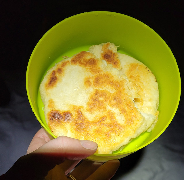
Carolyn and Steve slept like the dead all night while me and Brandon listened to the cacophony of their snores. We had a bit of a lie in (for us) and got up around 8:30am. Meals are always a bit slow on snow camping trips because it takes so long to melt snow and boil water. Brandon decided to use his alcohol stove on this trip, which works well once it get’s going, but takes a long time to properly heat up. We concluded it’s good for cooking, but the traditional white gas stove is better for melting snow because the condensation on the pot was dripping into the alcohol stove and suppressing its burn.

IMG-20220123-WA0031

After a leisurely breakfast we packed up everything to head back down the mountain. As always, when you’re done, make sure to fill in your holes so as not to leave hazards for future skiers. It was about noon when we left the campsite, but we made a much quicker descent than our 5 hour trek in. The actual Poland Lake trail is about 4km and it felt a lot easier after a day of rest. We went the correct way down the ski hill on the way back and hiked along the edge of the green run. We did see some signs pointing into the woods the for “Poland Lake trail”, but it was clearly a brand new trail that the resort was promoting and it didn’t look marked or established, so we opted not to use it. We did run into a resort employee in the parking lot and he confirmed it was new and said they were hoping to improve it, so hopefully next time we visit we’ll be able to use that trail!

IMG-20220123-WA0027

We did encounter one odd thing on the trail that I wanted to bring up. When we were hiking along, we saw that someone had written “help” in the snow. It was right at the point where the previous tracks had stopped (where we started breaking our own trail), so we assume the individual turned around and went back. We did search around the area for anything suspicious and blew our whistle and did some voice calls, but didn’t find anything. We reported it at the resort before we left and they hadn’t received any missing person reports, so we think it was probably someone just messing around. Maybe it wasn’t, but something to think about when you are in the backcountry and what kind of message you are leaving for others.

20220123_131753

Anyways, it only took us 2.5 hours to get to the bottom of the resort and then Steve and Brandon kindly offered to walk back the road to strawberry flats to get the cars. Me and Carolyn hung out and ate lunch while they were gone. I’ve been really into cold soaking my lunches lately and tried a cold soak taco salad that turned out amazing and was so delicious to eat! I’m working on lots of recipes for the upcoming summer season and hope to share them on the blog before then!

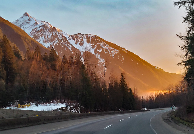
Otherwise it was a pretty uneventful trip back to Vancouver, although we did get a gorgeous sunset over the mountains driving back through Chilliwack! Definitely recommend Poland Lake after this experience, just make sure you take the winter route!

PSX_20220125_142407
Advertisement

Hiking Slesse Memorial Trail

Slesse Memorial Trail has been on my bucket list for a while, but the access road is a little bit dicey so we’ve been waiting for the right opportunity. In late September, me, Seth, and Brandon decided to make a go at it.

Slesse Memorial is a 12km out-and-back trail located off Chilliwack Lake Road. After having driven the access road, we wouldn’t say that you have to have 4WD to get to the trailhead, but high clearance would definitely be an asset. You won’t get there in a car, but potentially in an AWD SUV. Personally, I wouldn’t take my Hyundai Tucson out there because I’m not comfortable driving in terrain with water bars, but Brandon thought you could probably make it there in one if you wanted to try.

20210925_094750

Either way, we had no trouble getting there in Brandon’s 4runner. The nice thing is it’s not a long access road. Cheam Peak is located in the same area and it took us about an hour to drive 9km on that road – the access to Slesse probably only took us around 15-20 minutes. There’s a small parking lot at the end and there are two branches from there. One branch continues on in the same direction as the road coming in, and the second branch is on the left and continues up a rocky narrow road. The second branch that goes up continues on to Mount Rexford and my GPS indicated that we needed to continue up that road about 600m and then take a right branch onto the old Slesse Memorial Trailhead. I say “old”, because Brandon’s GPS showed a second trail leaving on the straight branch out of the parking lot, which we later learned is the “new” trailhead.

20210925_104055

I recommend taking the newer trailhead (the right of the two forks). Either will get you there and they do meet pretty early on the trail, but the newer trailhead is slightly shorter, easier, and more well maintained. We missed the old trailhead on our first pass and had to double back to find it tucked in the woods.

The first half of the trail meanders through the forest and isn’t very difficult. There are some tree roots to step over, but it’s not overly technical. Shortly before the memorial plaque, you pop in and out of the woods and get a few glimpses of Mount Rexford across the valley. We went in late September and the trees were just starting to change colour. We were a bit too early for full colours, so I’d recommend early October instead.

PSX_20210929_205451

The memorial plaque is located around the halfpoint of the hike and has a beautiful view looking up towards Slesse Mountain. The trail is called Slesse Memorial Trail because a commercial jet crashed on the side of the mountain in Dec. 1956, killing 60+ passengers and crew. The plane was flying from Calgary to Vancouver when it disappeared and it wasn’t actually found until 5 months later when a climbing crew accidentally spotted it on the side of the mountain. Due to the challenging locating, the bodies were never recovered. You can’t see the crash along the trail (at least we didn’t), but some of the debris has been collected at the top of the trail. I’m not sure at what point this was done, but these days there are signs indicating not to do this.

HOP_6344

We came for the view versus the memorial, but it was very interesting and we spent a lot of time thinking about it, making it a bit more of a somber hike. After the plaque, the trail gets a lot steeper. I thought we might need to do some way finding on the trail, but it’s easy to follow, just steep. There were a lot of old blueberries along the trail, so I could see it attracting bears, but on this occasion the berries only attracted Sadie. She discovered them growing there and wouldn’t stop picking and eating all the berries! It was very cute.

20210925_135450

In all it took us just over 3 hours to get to the top. It’s an interesting trail because it doesn’t go to the top of the mountain, but rather the base of it. A lot of the mountains in this area are forested, but Slesse is sheer rock with no vegetation growing on it. It’s very steep, so I’m sure it attracts climbers, but for hikers, the trail ends at the base of the mountain. There’s a beautiful 360 degree view and you can climb up a bit further if you’re feeling adventurous. There’s a long flatter section of rock, with a glacier coming down one side and the sheer rock face at the back. I say “flatter” because the rock is still a lot steeper than it looks. Me and Brandon explored up a bit further, which has a gorgeous view looking back towards Rexford.

20210925_135652

Be careful where you explore though, it was a surprisingly hot day for late September and the glacier was on the move while we were there. At one point there was a very loud rumbling and we watched as a big snow patch at the bottom of the glacier slid down part of the mountain. So we stayed away from that section and explored directly under Slesse, where there was still a bit of snow, but much less and not as steep.

PSX_20210927_223317

The steep uphill section does make for a slow descent on the way back. We left around 2pm because we didn’t want to get stuck hiking in the dark. We inched our way down the top section, but were able to pick up the pace a bit once we got to the flatter bits. It’s a pretty narrow trail, so it can be a bit tricky passing people. We only saw 2 other people on the way up, but passed a handful of people on our way down.

HOP_6383

Overall it was a nice hike. It was a lot more forested than I was anticipating, there’s a few peak-a-boo viewpoints, but not too many views until you reach the top. If you have the time to explore at the top though, there’s quite a bit of open terrain. We finished the hike around 5pm and still had lots of daylight left, but I’m glad we turned around when we did because the sun goes down over the mountains on this trail pretty early, so it was still quite dark hiking back through the trees at the bottom. I did really like the hike and would love to return and do more hikes in this area!

HOP_6405

Hiking Joffre Lakes

I’ve written about a lot of hikes, many of which are super popular. I found the time to write about Garibaldi Lake twice and I’ve written about Elfin Lakes a whopping 5 times, but somehow I’ve never found the time to write about one of Southwest BC’s most quintessential hikes: Joffre Lakes.

Joffre Lakes is a gem of a provincial park located about 30 minutes out of Pemberton on Duffey Lake Road. It’s a bit of a trek for a day hike from Vancouver, but every year swarms of people flock there to discover the brilliant blue glacial lakes for themselves. The park was closed through most of 2020 due to Covid-19 and re-opened in summer 2021 with a new day pass reservation system in place to manage crowds in the park. This is a free day pass that has been introduced in several of BC’s most popular parks to curb the flow of visitors. A lot of people are opposed to the day pass system and BC Parks has been widely criticized for it, but while I have many criticisms of BC Parks (mostly to do with their poor online system and cancellation policies), I have to admit I am a fan of the day passes. It keeps the crowds down and removes the stress of having to get up super early to ensure you find parking.

DSC00537

The first time I visited Joffre Lakes was in 2015 and while I was astounded at the beauty of the park, I had to admit that the swarms of people definitely took away from the experience. I visited on a beautiful Saturday in August, so I know there would likely be less people on a weekday, but the park only has one major trail and it’s only 11km round trip, so it’s not a lot of space for people to disburse along the trail, even on a less busy day. There were literal greyhound buses toting group tours of up to 50 people along the trail, so it was hard to get a moment to yourself anywhere on the hike. That said, a lot of people only hike to the second lake, or if they do hike to the third lake, they stop at the head of the lake. If you hike around the back of the third lake, where the campsite is, I did find it to be much less crowded.

DSC00546

When the park re-opened this summer, I thought it might be time to finally re-visit it since Canada is still mostly closed to international tourists. Emily and my parents visited during the first week of September and we decided to make the trek out there on a week day to hopefully find a bit of solitude on the trail. There’s no question that with the day pass, parking was much easier. I think they’ve added an overflow lot since my last visit and we had no trouble finding somewhere to park. It was still quite busy for a week day in September, but much less crowded than my first experience.

DSC00552

Like I mentioned, the trail is only 11km round trip if you go all the way to the campsite (which lots of people don’t), and has about 400m of elevation gain. It’s a very well maintained trail, so it is good for beginners. There are 3 beautiful lakes located in the park, making it easy to customize your trip. The first lake is only about 5 minutes in along the trail, so it makes for a good pit stop if you’re just passing through and want to stretch your legs. From there, the trail continues up through a boulder field (the trail is backfilled though, so easy walking) with beautiful views of the surrounding mountains. This is where most of the elevation gain is done along the hike and is the longest stretch between lakes.

DSC00562

Eventually you pop out of the woods along the edge of the second lake, which I would say is the most popular of the three. The water is a gorgeous green hue and Matier Glacier is framed through the trees at the end of the lake. I’ve visited the park 3 times in total and always opt to eat my lunch at the second lake to bask in the views. On this occasion, I convinced my mom to take a quick dip in the water with me. I’ve swam in a lot of alpine lakes over the years and Joffre is definitely one of the coldest! It is numbing, so if you opt to swim, be prepared for a quick dip in and out.

DSC00639

One of the other highlights of the second lake for me is that at the back of the lake there is a beautiful stepped waterfall cascading down from the third lake. It’s only a short hike between the second and third lakes, so I definitely recommend going up to the third lake, even if you opt not to hike around the lake to the campsite. The third lake has incredible views looking up at Matier Glacier.

DSC00582

On this trip, we ended at the base of the third lake (which is a round trip distance of 8km), but on my first visit Seth and I opted to hike the entire way around to the campsite. If you continue past the campsite you can hike up onto the big rock overlooking the lake, which is my second favourite view in the park after the second lake. From there, the surrounding mountains come into view on the opposite side of the lake, making for beautiful photos.

DSC00605

All in all, it took me about 5 hours return trip on both visits. It’s a beautiful park that’s 100% worth ticking off your bucket list, but I don’t think it would even rate top 10 on my list of trails overall. It’s just too crowded. If you choose to visit, please treat the area with respect – take all your garbage with you and make sure to leave no trace. Sadly the area often gets trashed due to its popularity and we want to preserve this beautiful park for generations to come!

The view from the back of the third lake – only photo from my 2015 visit