Hiking Trophy Meadows

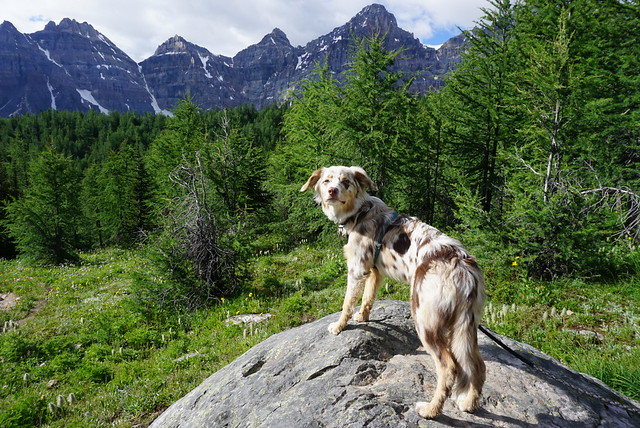
I recently posted about my experience backpacking the Berg Lake Trail in Mount Robson Provincial Park. While that was an adventure on its own, it wasn’t the end of my trip. We had a few more holidays left after finishing Berg Lake and we decided to visit Wells Gray Provincial Park on the way back to Vancouver.

Wells Gray Provincial Park is sometimes better known as “the waterfall park” and is popular both among British Columbians and tourists. It’s a large park located north of Clearwater, which is a ~5 hour drive from Vancouver. Like I said, the park is most well known for its waterfalls, but it’s also popular for paddling, with lots of water access campgrounds located on Murtle Lake and Clearwater Lake. It also has some really nice wildflower hikes. We didn’t have the time to do any paddling, but we set goals to see waterfalls and wildflowers!

PSX_20250820_184933
PSX_20250820_184513

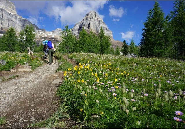
My post on waterfalls is coming next week. After spending a night in Clearwater to shower and treat ourselves to real food, our first stop in Wells Gray was to visit Trophy Meadows along the trail to the Sheila Lake Wilderness Area. It was the first week of August, so it was a little past peak time for wildflowers, but there was still lots blooming in the meadows. Access to the trail is at the south end of the park, very close to Clearwater, so you don’t have to drive too far. Take a right onto Spahats Creek FSR, right after you pass the turnoff for Spahats Falls. From there, continue on the FSR to Road 201, which will take you to the trailhead. It’s a gravel road, so it’s not in great shape, but you should be able to make it all the way to the trailhead in most vehicles.

PSX_20250820_184636
PSX_20250820_184834

I’ve heard this trail is really popular and can get very busy, but we visited on a Friday, so the trail was pretty much empty. The trail starts uphill through the forest for ~2km, with over 200m of elevation gain, before you reach the start of the meadows. Once you reach the meadows, you can really take your time and customize the trail to whatever length you prefer. The meadows are huge and sweeping and completely covered in wildflowers. It’s very beautiful and you can see the surrounding mountain peaks in the background. There’s limited shade though, so I recommend going early to avoid the midday heat. 

PSX_20250908_191914
PSX_20250908_191613

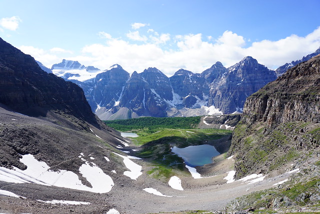
The meadows continue for ~2.5km and there is an outhouse located around the midpoint. Once you reach the end of the meadows (around 4.5km into the trail), it’s not much further to hike to the Sheila Lake Wilderness Campground. You can hike up to a little plateau that looks down on Sheila Lake. There’s ~20 tent pads located around the lake and it’s a really beautiful campsite. The tent pads are all in great shape and there’s a few small open-air shelters around the lake that have been constructed for cooking. There was only 1 tent set up when we visited, but I think it gets pretty busy on the weekend and we did see a few groups hiking in on our way out later in the day. It would be a really nice place to camp and I’d like to return someday for an overnight.

PSX_20250908_082447
PSX_20250908_191101

If you hike all the way to the end of the meadows, I recommend adding on the loop around Sheila Lake. There’s a few small tarns up there and it makes for a nice little circuit before heading back to the trailhead. It’s ~12km round trip if take this route. If you’re looking to do a shorter hike, then just hike through the meadows. If you’re looking for a longer hike, it is possible to continue a little further. We hadn’t planned to go further, but we were feeling strong after 6 days at Berg Lake, so we decided to hike up to Long Hill.

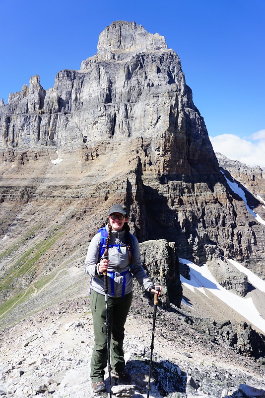
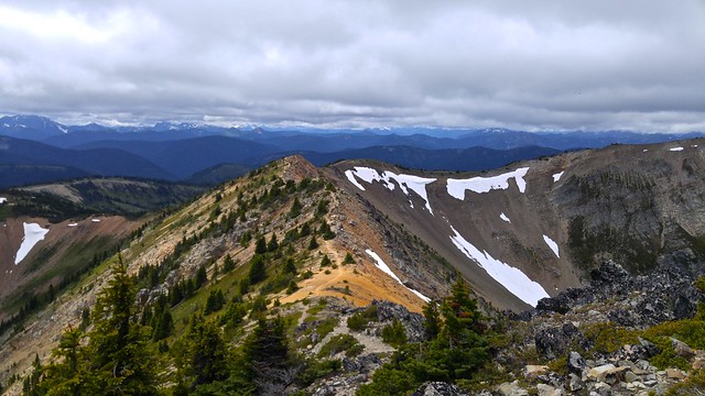
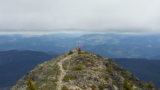
The alpine area at Sheila Lake is all very open and you can see Trophy Mountain and the surrounding peaks from the lake. There’s not really an official trail past the lake loop, but you can follow a faint trail up to the pass at the base of Long Hill. Some people will even route-find their way up Trophy Mountain, but we decided to target Long Hill for our lunch break. It added another 3km to our day (15km in total), as well as another 150m of elevation gain. 

PSX_20250908_082624
PSX_20250908_082905

The trail continues past some more ponds and then gets pretty steep as you hike up the mountainside to Long Hill. There’s a few boulder fields that you have to guess your way across, but overall it’s not too difficult. There’s not much trail to follow, but it’s not hard to read the terrain. We stopped at the top to enjoy our lunch and the view of the alpine, though it was pretty windy. We returned via the campsite and of course, I had to go for a little swim in one of the ponds. 

We saw a marmot on the way back and enjoyed the meadows just as much on the way down. Actually, I’d say we enjoyed them a little bit more on the way back as the lighting was better. Overall it was a 6 hour hike for us, which was a bit ambitious immediately after hiking 6 days to Berg Lake, but we really enjoyed it and I would definitely recommend. We did climb 650m of elevation across the 15km trail, but it’s not very steep at any point (except for the summit to Long Hill), so I’d say it’s a pretty accessible trail for most people. 

PSX_20250908_191255
PSX_20250908_191343

Hiking Sentinel Pass

It’s been almost a year now since I visited the Rockies, but I never found time to post about the 2 hikes I did last August, so it’s time to feature them now! Hopefully it will be helpful if you’re planning to visit Banff this year. Sentinel Pass was my first hike in Banff National Park and I really feel like I started at the absolute best that Banff has to offer. Seriously, this hike was unreal! It’s not too challenging and it has the most amazing views – I loved every second of the day hike.

So first things first, let’s talk about how you get to the trailhead because it’s definitely worth talking about. Two of the most popular sights in Banff National Park are Lake Louise and Moraine Lake. Lake Louise tends to get most of the press attention, but for those in the know, Moraine Lake, located just up from Lake Louise, is the real shining jewel of the park. But if you want to experience it, you have to get there early. Lake Louise has a huge parking lot and on summer weekends it usually fills up by 8am. On week days you can probably get away with showing up by 10am, but likely it depends on the weather. I believe you can usually shuttle up to Lake Louise from the village or overflow parking lots, but the shuttles are currently not running because of Covid.

DSC07301

Moraine Lake is located 14km away from Lake Louise on a direct access road up to the lake. The parking lot for Moraine Lake is much much smaller and once it’s full for the morning, park staff will block off the access road to limit traffic up there. So you can’t bank on showing up late and just circling the parking lot – you won’t even be able to get up there. Same as Lake Louise, there is a shuttle bus that runs to the lake, but it’s not running this year. So if you want to visit the lake, your best bet is to come really early or really late. I read online that you need to be at the road by 6am to get a parking spot, which is probably true on a weekend, but we got in around 8am on a weekday. They will periodically open the road up again later in the day, but lucky timing is really everything if you decide to wait.

DSC07074

Once you make it to Moraine Lake, the world is your oyster! This is seriously one of the most beautiful alpine lakes that you can drive to. Canoeing is really popular on the lake – it’s first come first serve for bookings, but I suspect it’s probably not too difficult to rent this year with the limited traffic and shuttles not running. I would love to canoe up around the lake, but on our visit we had other priorities.

From the lake, there are tons of hikes to explore! The most popular trails seem to be the Rockpile Trail and the Moraine Lake Trail. Rockpile is located right at the parking lot and I regret not doing it because it’s pretty short and I imagine it gives you a great view of the lake. Moraine Lake Trail is about 3km long and goes up to the end of the lake. We had planned to do this trail at the end of our hike up Sentinel Pass, but ended up skipping it because Sadie was really tired. There’s several other trails leaving from the lake, but the other two main trails are Sentinel Pass and Eiffel Lake/Wenkchemna Pass. I’ve heard Wenkchemna Pass is also amazing because it hikes into the continental divide, but it’s a bit longer, so we opted for Sentinel, of which I have no regrets.

DSC07101

Sentinel Pass starts off with a climb up the mountain to get into the alpine. It’s steep, but nothing too crazy and the trail just switchbacks up and away from the lake. The advantage of starting early was that the temperature was still chill, so it wasn’t too bad climbing up there. After about an hour, you pop out of the woods into the alpine meadows, and from there the rest of the hike is super scenic. There’s some more climbing through the meadows before you come to a large meadow with two lakes, known as the Minnestimma Lakes, and the most amazing view looking back at the ten peaks surrounding Moraine Lake. It was especially beautiful when we visited in early August because the meadows were filled with wildflowers! I have a real weakness for meadows and wildflowers, they’re pretty much my favourite alpine scenery, so I was in hiking heaven.

Screenshot_20210414-143428_Instagram

From the meadow, you can see that the trail continues up the side of the mountain and then switchbacks through the pass between Pinnacle Mountain and Mount Temple. This is where the hike gets a little more challenging. If you’re afraid of heights you might find this part a little scary, but I never felt unsafe on the trail at any point. There was still a little bit of snow left in one section, but it was easy enough to pass across. Watch for wildlife as you make your way through the meadows and up the final climb because we saw so much wildlife on this trail! The first meadows earlier on are filled with ground squirrels, and the higher meadows have tons of marmots! We could also hear lots of pika, which are harder to spot than the marmots, but we did spot one later in the day thanks to Seth’s determination.

DSC07243

The view from the top of the pass is incredible, but honestly, so was the view from the meadow. It is worth pushing to the top of the pass to see down the other side, but if it’s too much, don’t sweat it, the views from the lakes are honestly just as good. It was pretty hot when we hiked the pass, but it gets chilly and windy at the top, so be prepared. It is possible to seek shelter while you eat lunch at the top, but we opted to just brave the wind so we could enjoy the views.

DSC07129

While we were on top, there were some other hikers coming up the pass from the other side. I could see a map for this trail on my GPS, but I wouldn’t recommend it unless you’re experienced. It’s hard to discern any path from the other side and you mostly just create your own path up the boulder field. The trail officially ends at the top of the pass, but we decided to explore a little bit further. There is an unofficial path up Mount Temple, but again, it’s more of a climbing path – it’s misleading how long it is to get up to the top of Mount Temple and I wouldn’t recommend doing it without a helmet. We just went about 100-200m further, snapped some photos, and then started to make our way back down the pass.

DSC07180

It was an early morning, but the trail was pretty empty, which made for a great hiking experience. There were definitely more people coming up when we were on our way down, but it never felt overly crowded. We took our time on the way down, enjoying all the beautiful views, taking pictures of the wildflowers, and looking for marmots. Sadie did well on the hike and had a great time, especially on the snow section, but after Banff we decided it was probably a bit too much for her, so we’ll probably wait a few more months before taking her on any more large hikes. Like I said, we wanted to do the Moraine Lake trail, but eventually abandoned the idea to give Sadie a rest.

So in conclusion, this was really an excellent hike. I would absolutely recommend taking the time to do it and know I’ll have to return again some day to do the Wenkchemna Pass hike and the rest of the trail around the lake!

DSC07207

3 Brothers Mountain Day Hike

I haven’t written about many of my day hikes on this blog. I’ve gone on tons of them over the years, but I tend to write more about my backpacking trips since sometimes it seems like there’s not a whole lot to say about day hikes. But I’m excited to write about 3 Brothers Mountain and have decided to make it the first post in a mini-series about E.C. Manning Provincial Park. My first time visiting Manning Park was in 2016. Since then I’ve hiked and camped all over the park and it has become my favourite Provincial Park in BC to date. The first time I travelled there was with Emily when she was visiting from Newfoundland after finishing her Engineering degree. She stayed with me for about a month and we decided to spend one weekend car camping in the park. It was just the two of us and though it was the middle of July, it was a pretty cold weekend. I’ve had both hot and cold trips to Manning Park since then, but Emily seems to always be there for the cold ones, so I’m starting to think she might just be bad luck.

20160723_183000

Anyways, after a cold night in the tent, we decided to hit the trail to try and burn some calories and warm up. It wasn’t very warm when we woke up, but as we started driving up Blackwell Road to get to the trailhead, the car thermometer kept dropping. By the time we reached the top, it was only 6 degrees. We hadn’t anticipated it would be so cold, so we grabbed all the sweaters and coats we had in the car and set off. It was a rough start when I realized I’d brought a camera with a empty SD slot, so I was forced to use my cell phone for photos. Probably not a big deal for most people, but I love my little mirrorless camera, so I was pretty bummed about it. You’ll have to excuse my photos for not quite being up to standard.

If you’ve never been up Blackwell Road, it’s worth going up there just for the view. You don’t even need to be a hiker. There’s an amazing viewpoint about halfway up and then another great view of the surrounding wilderness from the parking lot. If you have enough time for a short hike, follow the paintbrush trail, which does a short little loop near the parking lot and is covered with wildflowers (hence the name) around late July/early August. We had set our sights a little higher though and were aiming for 3 Brothers Mountain, a 21km out and back trip. The actual name of the trail is the Heather Trail and it continues on past 3 Brothers to Kicking Horse Camp and Nicomen Lake. I have also hiked that trail, but it’s a story for another time.

20160723_112711

The Heather Trail and 3 Brothers Mountain are really top notch though. Because you’ve driven all the way up Blackwell Road, most of the elevation gain is done by car. That means the trail is already starting in the alpine, which makes the entire trip incredibly scenic. There is still almost 500m of elevation gain on the trail, but a lot of that is at the very end when you summit the First Brother Mountain, so spread over the rest of the 10km, the elevation gain is not bad at all. You start out on the ridge from the parking lot and descend about 5km to Buckhorn Camp. It’s a very quick 5km and we did it in about an hour. It’s a good place to stop for a pee break and a snack because there are several picnic tables and camping pads. I’ve never seen anyone camping there, but I could see it being a great campsite if you wanted to drive out after work on a Friday and get an early start on the Heather Trail in the morning.

20160723_122513

After Buckhorn Camp, the trail starts to climb again and that’s when things get truly scenic. The remainder of the trail is through alpine meadows and since we were visiting in mid July, the wildflowers were starting to come out. They weren’t quite at their full glory, but definitely picturesque. The only downside of course is that the Heather Trail is known for it’s wildflowers, so it attracts a lot of people at that time of year. Overall there’s a lot of trail to spread out over, but we were still regularly passing large groups of people that seemed to be doing Meetups at the trailhead. We were making a pretty brisk pace to try and stay warm, so we ended up passing a lot of people. But the trail is really beautiful as you look out over the green meadows and wildflowers out towards the North Cascades, so you can kill a lot of time taking photos!

20160723_122907

About 9km in you reach a junction – you can either continue on along the Heather Trail for another 11km to Nicomen Lake and beyond, or you can take the branch that leads up First Brother Mountain to the viewpoint and our final destination. The name 3 Brothers Mountain is somewhat confusing. I couldn’t find a whole lot of information about it, but from the Park website I learned that the alpine meadows used to be used for sheep grazing until 1931, when they created the 3 Brothers Mountain reserve, which included the 1st, 2nd, and 3rd Brother mountain peaks. It later became part of Manning Park in 1941. There’s the trail branch to go up the First Brother and the Heather Trail passes by the 2nd, 3rd, and 4th Brothers along the way. But don’t ask me what the deal is with the Fourth Brother and why he was excluded from the trail and park name because I really have no idea why.

20160723_130743

We were just aiming for the First Brother on our trip though. It was a pretty overcast day, so while we’d been able to enjoy the views on the way up, some of the higher mountains were still shrouded in fog – this included the First Brother. We branched off the trail and started climbing into the clouds, lamenting that it was both getting colder as we climbed and the view worse. We made it all the way to the signpost at the top of the mountain, but we couldn’t see anything from there and it was very cold and windy. We sheltered behind some rocks to eat our lunch, but while we were eating, the wind finally moved the fog out and the view started to clear for us! From the top you have an incredible 360 degree view in all directions. The climb up is not for the faint of heart – it is pretty steep, with lots of rocks to climb over as you make your way along the ridgeline with a drop on either side of you. It made for an incredible walk back down though! Everything we couldn’t see on the way up came into view on the way down and it took us a while to get back as we were constantly stopping for photos.

20160723_131322

Even though this is a 21km hike, which I would normally expect to take a minimum of 7 hours, but more likely 8 or 9, somehow me and Emily did the whole thing in just 6 hours, including lunch break. This is a bad pace by which to measure other hikes because that is a super intense pace for us, but it does serve to highlight that the topography is definitely easier on this hike than others I’ve done (and that is was COLD). Please don’t use this as a reference for how long this hike takes though because another group of friends that I often hike with did the same hike in 10 hours. We ended up running into one of my friends on the way out. He’d spent the night at Kicking Horse and was heading back to the parking lot, so we did the last 6-7km together. He’d been planning to stay a second night, but he said it was just too cold up there to stay any longer. So we made good time on the way out and before we knew it we were back at our campsite again, building a campfire to warm ourselves up properly!

20160723_123457

So my first visit to Manning Park was a little rough around the edges, but it was the start of a long and beautiful love story! That first visit inspired me to hike the Skyline II Trail a year later and the entire Heather Trail the year after that. We continue to car camp in the park annually and it’s become one of my favourite places to snowshoe in the winter. It’s a beautiful park, but it attracts less visitors than Garibaldi (I don’t actually know if this is true, but it definitely feels like it), so even though I love both parks, Manning makes for a more enjoyable experience. Plus the night sky in Manning is to die for! Tune back soon (hopefully), for more stories from my many adventures in Manning Park.