In my humble opinion, one of the most underrated National Parks in America is North Cascades National Park. This is likely because of its remote location in the north of the country, but neighbouring Mt. Baker-Snoquolmie National Forest / Mt. Baker National Recreation Area is only a ~2 hour drive from Vancouver (and is more or less an extension of the park), so I’ve made a few trips down there over the years and I’ve yet to do a hike that wasn’t jaw-droppingly beautiful. It can get fairly busy, but compared to other National rec sites, it receives relatively few visitors (and half of those visitors are likely Canadian).
For some reason, almost all the hikes I’ve done in the North Cascades have been in the Fall, though I have done Artist Point twice in the winter. I first visited in 2018, and even in the last 5 years, the area has definitely grown in popularity in the Fall. When we crossed the border on this visit, the border agent asked where we were going, and when we said “hiking near mount baker”, he said, “you and every other Canadian that’s crossed the border today”.


This was my first time going down to the US for a hike since before the pandemic and it only cemented the idea that I need to visit more. To date, I’ve done the Skyline Divide, Yellow Aster Butte, and Chain Lakes, and they’re all beautiful. I honestly can’t pick a favourite between any of them. We added Winchester Mountain to the list over the Canadian Thanksgiving weekend and it was another stunning hike! I feel like I’ve only scratched the surface on the plethora of hikes in this area, so I’m determined to visit even more next year.
Like I said, it’s only about a 2 hour drive from Vancouver, unless there’s a long wait at the border, which is not uncommon. We always cross the border at Sumas and take Highway 542 towards Mount Baker Ski Area. You don’t need to do much pre-planning, except to get a $5 parking pass for the National Forest. These aren’t limited or reservation based, so just pick one up online before crossing the border to leave in your car. If you forget to get one online, you can get one from the Visitor Center, but their hours are very limited and it’s not always open.


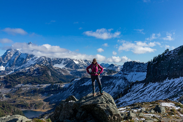
If you’re visiting in the Fall, Yellow Aster Butte is by far the most popular hike (followed closely by the Chain Lake trail). The hillside turns bright yellow and attracts a lot of visitors, so I recommend arriving super early for this hike as parking is limited for the hordes of people that want to do the hike. I hiked the trail with Lien several years ago and parking wasn’t too much of a problem, but we had to drive past the Yellow Aster trailhead on our way to Winchester this year and it was an absolute gong show! There were hundreds of cars blocking the road and you more or less had to park half way down the mountain if you arrived mid morning (like we did).
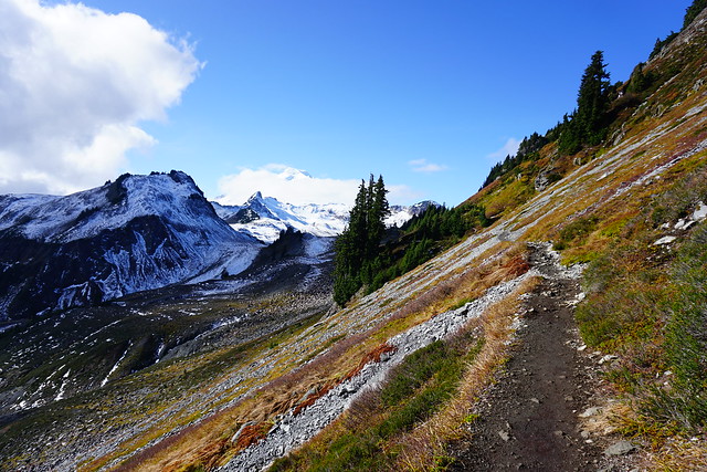
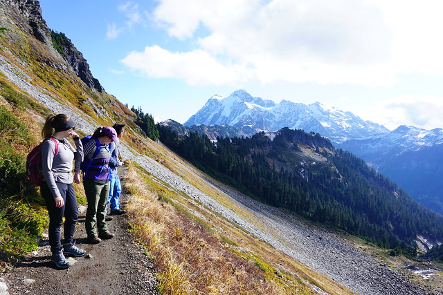
This was the main downside of going to Winchester Mountain. The trailhead to Winchester is located several kilometres uphill past Yellow Aster Butte, but it requires 4WD to get to the top, so it considerably thins out the crowds. Some people will hike all the way up from the Yellow Aster parking lot (which in my opinion is still worth it), but it was nice to be able to drive right to the trailhead in Brandon’s 4Runner. In my opinion, Winchester is a more scenic and easier hike than Yellow Aster Butte. The key reason for this is because you do a lot of the elevation gain in the car, so by the time you reach the trailhead, you’re already in the sub-alpine and the entire hike has incredible views of the backcountry.


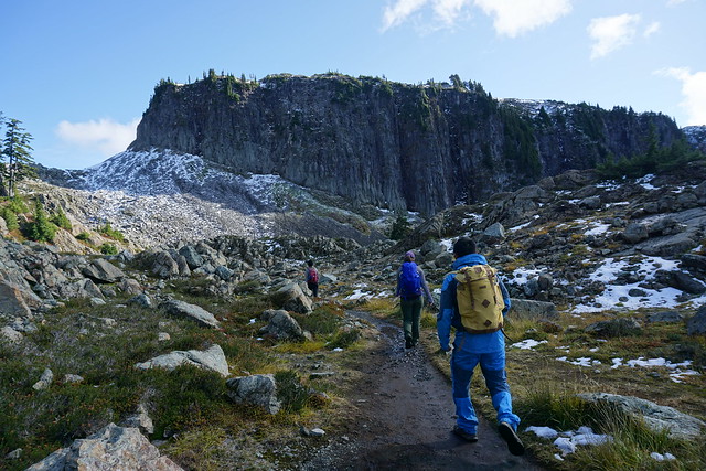
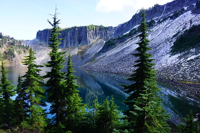
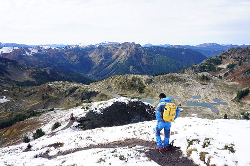
Parking is at Twin Lakes, which is aptly named for the pair of lakes at the base of Winchester Mountain. There are actually several rec sites that are first come-first serve at the lakes (and are gorgeous), so we’re keen to come back some time in the summer to stay overnight. Fortunately we didn’t have trouble finding parking at Winchester and even on Thanksgiving weekend, there were lots of empty campsites.
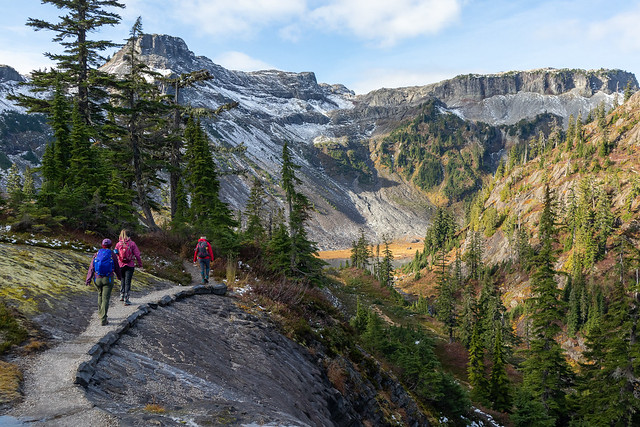
The entire hike up to Winchester Lookout is less than 6km round trip, but it is steep and covers ~400m in elevation gain from top to bottom. It’s a steady climb, but it’s one of the most colourful fall hikes I’ve ever done on the west coast! I personally liked it better than Yellow Aster Butte, but I did have better weather than when I did Yellow Aster. On this day, it was beautiful, warm, and sunny, with blue skies all day. I thought we were done for summer weather since it was October, but I was glad I packed a pair of shorts just in case. This is very subjective though because I did Yellow Aster and Chain Lakes at the exact same time of year and needed my parka on both of those occasions (though I also did the Skyline Divide in shorts in late October).


It took us under 2 hours to hike to the top and we stopped a lot to take photos and videos. Lien had a rough start to the hike – he unwisely had a dairy-heavy breakfast at the cafe we stopped at, and his lactose intolerance punished him for it. He disappeared up the trail while the rest of us were still packing our bags and we couldn’t find him (which is very out of character for Lien). We were surprised he’d gone so far ahead without us, but he eventually stumbled out of the bushes looking for my trowel and I force-fed him some pepto-bismal and he eventually recovered, lol.
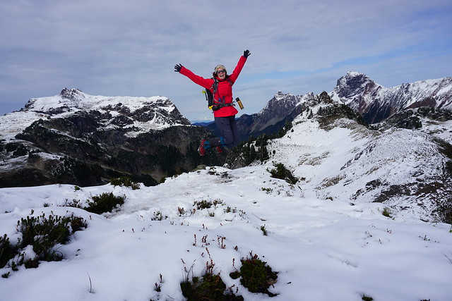
There’s an old fire lookout at the top of the trail, which I’ve seen featured on instagram several times. There’s one bed inside that you can claim if you’re lucky – I’m not sure how popular that option is though because no one was using it on this beautiful sunny day. Like all the hikes in this area, there are gorgeous views of Mount Baker and this particular lookout points north towards Canadian Border Peak. There’s another trail that leaves from the base called High Pass trail and goes up towards Larabee Peak that I’d definitely be keen to visit on another occasion.


We hung out at the top for an hour or so before heading back down. It’s all downhill on the way back, so it makes for a pretty quick day hike. The pay-off for the level of effort expended is very high, but most of the hike is exposed, so if you have a fear of heights, this might not be the best choice. If you don’t have 4WD, the distance from the lower lot is ~3.5km each way, so I still think it’s worth it to climb up, and odds are you might be able to hitch a ride with some other hikers. We would definitely have picked some people up if we didn’t already have 5 adults and an anxious dog in the car.
We finished the hike with a swim in Twin Lakes at the end. Actually, I should say, me and Lien finished the hike this way. Everyone else chickened out because the water was quite cold, but I’ll swim in pretty much anything, and Lien was keen for a bath. But in conclusion, it’s an absolutely fantastic hike and I’d love to spend some more time in this area in the next few years. If you’ve spent a lot of time near Mount Baker, please let me know your favourite hikes!