Skookumchuck Narrows is a short hike on the north side of the lower Sunshine Coast. I’ve been aware of its existence for years, but because it’s a short hike and quite far away, I’ve never had a good reason to visit. In 2023, I attended a wedding in Pender Harbour, which gave me a great excuse to finally make a trip out to the Narrows.
Skookumchuck Narrows is a natural phenomenon on the Sunshine Coast that requires a little bit of explanation of the area. The Sunshine Coast is actually connected to mainland BC, but can be confusing because it requires taking a ferry to get there. There’s no road to get there because it’s separated from the mainland by Howe Sound and the vast mountainous wilderness, so the easiest way to travel there is a 40 minute ferry from Horseshoe Bay to Langdale.
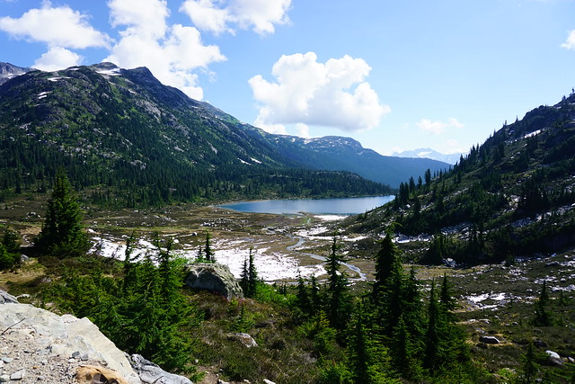
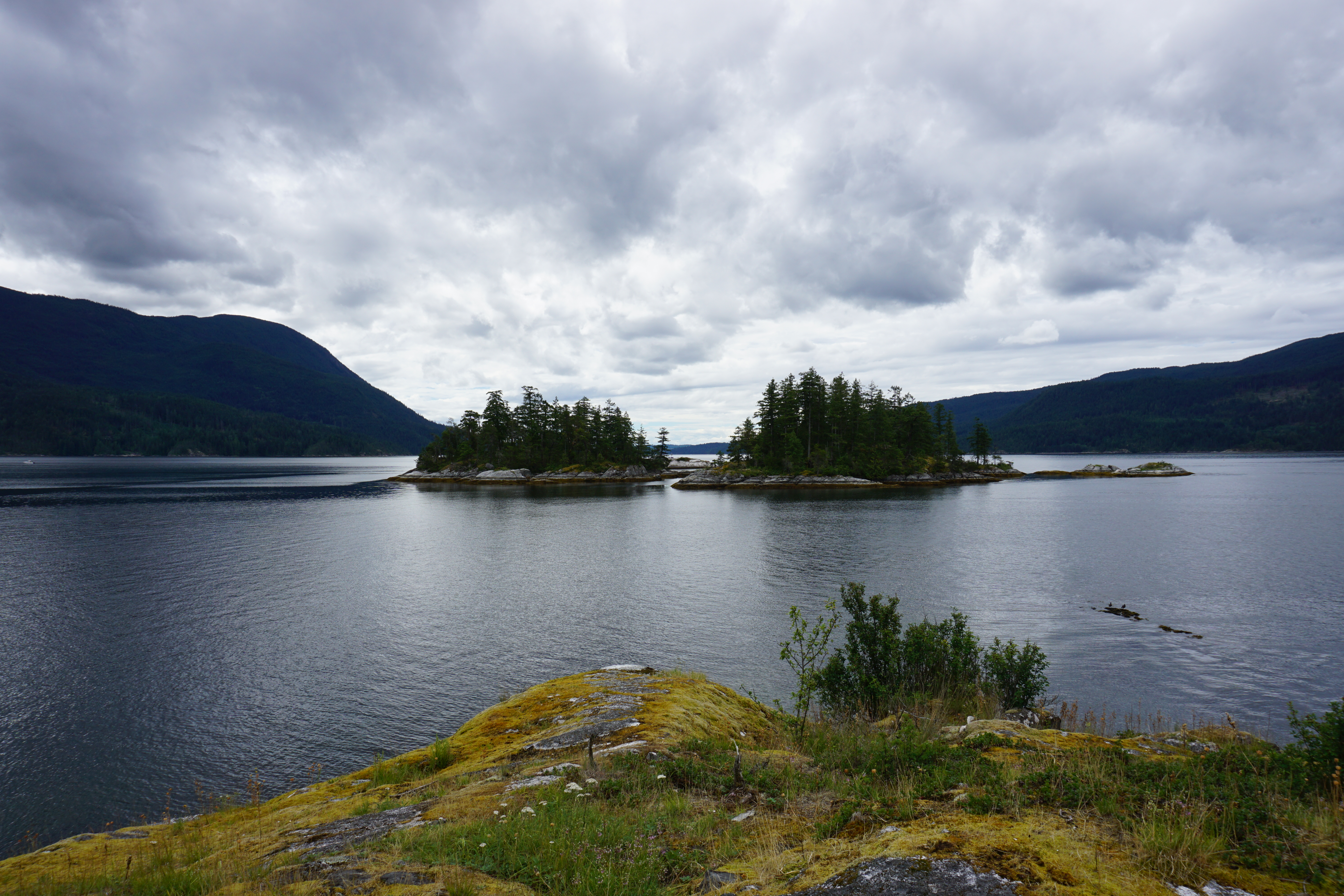
Once you arrive on the Sunshine Coast, you have to drive an hour and a half along the coast. Right before you reach the 2nd ferry at Earl’s Cove, you branch off the highway to drive out to Egmont. The interesting thing about this area is that, from Sechelt to Earl’s Cove, the Sunshine Coast is almost an island. The ocean flows down a large channel at Earl’s Cove and then Sechelt Inlet extends all the way back to Sechelt, with several arms branching off the main inlet. What this means is that every time the tide changes, there’s a significant amount of water flowing in and out of the inlet. The narrowest part of the inlet is the Skookumchuck Narrows, which is why, twice a day, you get this natural phenomenon happening in this area, known as the Sechelt Rapids.
If you’re an experienced paddler, you can paddle up to the narrows from Egmont, or if you’re less of a thrill seeker, like us, you can hike 4.5km from Egmont to the Skookumchuck Narrows Provincial Park. It’s a fairly easy trail. It’s partially on forestry road and then switches to nice forested trails. You can circle around Brown Lake and then you eventually come to 2 viewpoints of the rapids.
The first viewpoint is the more official viewpoint and gives you a great look at the inlet. It’s really beautiful, even without the attraction of the rapids. We enjoyed the view here for a while, and then continued on less maintained trail to the large flat rocks at Roland Point where you can watch the real thrill seekers attempt to whitewater kayak through the rapids. Because there’s so much water coming in and out of the inlet, in this area it creates these rapids where you can paddle almost stationary because of the conflicting currents. It’s a bit hard to describe, but a picture is worth a thousand words in this instance.
If you want to watch the paddlers, you do need to be cognizant of your timing. If I’m being honest, we didn’t really plan this visit at all and had no idea when was the best time to visit. There was no one paddling when we visited the first viewpoint, but our timing must have been perfect, because a bunch of paddlers showed up right when we got to the second viewpoint and we ended up sticking around for quite a while to watch them. It was very entertaining!
Once we had our fill, we started the hike back. The nice thing about this hike in the summer is that there’s a little cafe near the end of the trail, which is a great place to stop for treats. So we rewarded ourselves before returning to the car. I won’t end the blog here though, because we caught one more attraction before leaving Egmont. We started to drive back to the highway, but just out of Egmont, there’s a big lake called Waugh Lake that you can access directly from the road. There’s no beach and limited parking, so it’s more of a roadside stop, but I saw a dock and a few kids swimming there. Since it was so hot, I wanted to swim too, so we made a quick stop and me and Seth both went for a refreshing swim before starting our journey back to Gibsons.
So while I wouldn’t place this trail super high on the bucket list, it’s a great option for beginner hikers or if you just want to have a more relaxing, slower paced day. I had a really fun time and I’m glad I finally got the chance to visit this well known, but not super busy, area.
Welcome back to the second part of my 2-part series to help you get camping with minimal advance planning, in any season! Part 1 focused on permitted campsites (that don’t require reservations) and Part 2 focuses on unpermitted (free) campsites!
Camping is incredibly popular in BC, especially near Vancouver. The popular campsites require reservations that release 4 months out and being coordinated to plan so far in advance can be a real challenge for people. It might seem like all the good campsites are booked, but there are lots of great options that don’t require advance bookings!
Why do some campsites require a permit and others are free?
The simple answer is that a lot of free campsites are located on crown land or in BC recreation sites (also considered crown land). The land doesn’t have park status, so it generally receives limited maintenance or it is maintained by users and volunteers. As a result, free campsites are often more rustic than traditional permitted campsites. There are lots of campsites located on crown land that are privately managed, either by for-profit or non-profit groups, and those campsites will usually have a campsite fee to go towards ongoing maintenance, though some non-profits will fundraise for the upkeep of facilities, like on the Sunshine Coast Trail.
That said, there are still some free campsites located in provincial parks, especially the further you get from the lower mainland. I don’t know the exact reason why some campsites have permits and others don’t, but I think it’s likely related to the popularity of a park and how much maintenance the park gets. For example, I visited South Chilcotin Provincial Park last year for 6 nights and didn’t pay any camping fees, but the park is very remote, has limited infrastructure, and several of the places we camped were considered wild camping (no outhouse or bear cache). When sites become more popular, permits will often be introduced.
If you are visiting a free campsite that does not have bear cache facilities or an outhouse, it is absolutely essential to practice bear safety and leave no trace practices. You must hang your food or bring a bear bin. In addition, you must be prepared to dig catholes or use a wag-bag, and pack out your toilet paper, pads, and tampons. It is not acceptable to poop in the woods without burying it, or to leave your toilet paper around the backcountry. We are so lucky to have access to incredible backcountry in Canada and we need to respect it.
Hanging Lake is located in Whistler, sharing a trailhead with the Rainbow Lake trail on Alta Lake Road. Rainbow Lake is Whistler’s water supply, and as such, it’s a protected watershed area, so you’re not allowed to camp there. But if you hike a few more kilometres over Rainbow Pass to Hanging Lake, you can enjoy a nice view from the pass and a relaxing night at the lake. It’s a 10km trail to the lake, but the real challenge comes from climbing 800m of elevation along the way. There’s a fair bit of space for tents at Hanging Lake and there is an outhouse and a bear cache. You can also access this trail from the Rainbow Madeley trailhead near Madeley Lake.
In my opinion, Tikwalus Heritage Trail is an underrated trail along the Fraser Canyon. To access it, you take Highway 1 past Hope until you pass Alexandria Bridge Provincial Park. The Tikwalus Heritage Trail has been used by indigenous peoples for generations, and in more recent history, it was used by fur traders. It’s only 6km along a semi-loop trail to the campsite, but you’ll climb almost 800m in elevation, so it’s steeper than Hanging Lake. Most of the trail is in the trees, but there are some beautiful mountain views from the campsite. There’s lots of space for tents, as well as an outhouse and a bear cache. There’s no water source directly at the campsite, so fill up at the creeks on the way up to save yourself having to backtrack.
Deeks Lake and Brunswick Lake are both located on the Howe Sound Crest Trail, but are accessible from the northern trailhead at Porteau Cove if you’re not doing the 30km thru hike from Cypress Mountain. Both lakes are beautiful and offer an easier alternative to the strenuous Howe Sound Crest Trail. It’s 6.5km to Deeks Lake (which is the smaller site) and 10km to Brunswick Lake, however there’s almost 1200m of elevation gain along the way. Most of the elevation gain is in the first 6.5km to Deeks Lake, making this part of the trail the steepest on my list. Of the two lakes, Brunswick is the most scenic and has more room for camping. It’s also important to note there are no facilities at either site, so be prepared to hang your food and dig catholes.
Keeping in theme with the previous trails, the trail to Flatiron is just as steep, climbing over 800m in ~5.5km, with most of the elevation gain in the first 3.5km. It’s located in the Coquihalla Summit Recreation Area off Highway 5 and shares a trailhead with Needle Peak. The first section of the trail is a huge slog through the forest, but the views are incredibly rewarding. Once you pass the junction for Needle Peak, there’s a small lake where you can camp. You can also camp at the summit of Flatiron, but there’s no water source up there. There are no facilities at either site, so be prepared to hang your food and dig catholes.
Brew Lake is less steep than some of the other trails on this list, but still a big hike, covering 900m of elevation gain over 8.5km. However, if you have access to a 4×4 vehicle, you can reduce some of that distance along forestry roads. We parked along Brew Creek FSR, at the entrance to Branch 50, and hiked the entire trail from there, including 3.5km along other FSRs. This isn’t a very popular site, so it’s a nice place to go to escape the crowds. There are no facilities, so be prepared to hang your food and dig catholes.
We have finally arrived at some options that are not super steep! Both of these sites are located on the Sunshine Coast Trail, which has lots of possibilities for backpacking trips. The whole trail is 180km long, but there are lots of sections that can be done over a day or two. The campsite at Manzanita Bluffs, located on the north end of the trail, is especially beautiful. I also really like the campsites at Fairview Bay and Rainy Day Lake, located on the south end of the trail. All campsites along the trail have outhouses and most of them have bear caches or huts. They do not all have water sources, so plan accordingly. While these sites are free, I do recommend a donation to qPAWS if you opt to stay in one of the huts.
Tricouni Meadows is a popular campsite located northwest of Squamish. The trailhead is located on Branch 200, off of Squamish River FSR. If you can make it all the way to the trailhead, the hike to the campsite is just over 3km, with 250m of elevation. However, there was a large wash-out on Branch 200 when I did this hike in 2022. If you park at the wash-out, it adds 3km to the trail. In 2022, some vehicles could get through, but I’ve heard it’s gotten worse, so play it safe. There are 3 lakes near the meadows, with the campsite located at the middle lake: Spearhead Lake. It’s not a large campsite, so I recommend getting there early. There are no facilities, so be prepared to hang your food and dig catholes.
Blanca Lake is another campsite located northwest of Squamish. In general, I would say this road is in better shape than the road to Tricouni, but it’s further away. The trailhead is located off E300 on the Elaho Mainline. The trail is 4.5km, with almost 500m of elevation gain. It starts off pretty steep, but then levels out along the middle. The view from Blanca Lake is incredible and there is tons of space for camping. Give yourself extra time to explore around the alpine once you get to the lake. There are no facilities, so be prepared to hang your food and dig catholes.
Both of these campsites are located on the HBC Heritage Trail that runs 70km between Hope and Tulameen. Manson’s Campsite is located on the Hope end of the trail (off Peers Creek Road), so you don’t need 4×4 to access this site, but if you want to access Conglomerate Flats for a night, then you need 4×4 to get the trailhead at Jacobson Lake Rec Site (off Tulameen FSR). Both sites are beautiful, though Conglomerate Flats is the more stunning of the two. It’s 6.5km and 600m of elevation gain to Manson’s Camp from the southern trailhead, and 2.5km and 150m of elevation gain to Conglomerate Flats from Jacobson Lake. Both campsites have outhouses and bear caches.
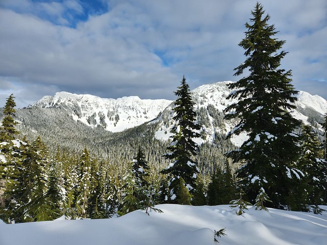
Both of these sites are located in the Coquihalla Summit Rec Area off highway 5. Falls Lake is a great site for beginners because you only have to snowshoe 1km along the road (which isn’t plowed in the winter) and 1km to the lake. Zoa subpeak is a bit more challenging as it’s 550m of elevation gain over 4km. Both trails are located in simple terrain, but make sure to stop at Zoa Subpeak – if you try and snowshoe all the way to the true peak, you will be entering challenging avalanche terrain. I’ve never actually been to Falls Lake, but I believe there is an outhouse. There are no facilities at Zoa Subpeak.
Ottomite Peak is also located in the Coquihalla Summit Rec Area off highway 5. The trailhead is at the Zopkios Rest Area. It’s a 4.5km trail with 300m of elevation gain to get to the summit. It was completely empty when I camped there, but the general area is popular among ski tourers, so you may see people along the trails for the day. The trail is in simple terrain, but always exercise caution – in general, I always recommend taking an AST1 course. It’s not a challenging trail, but there are no facilities.
Widgeon Creek is located near the lower mainland and is extremely popular on summer weekends. It’s a ~5 paddle across the Pitt River and up Widgeon Creek to get to the campsite. You can rent canoes or kayaks at Pitt Lake. There are lots of campsites and great facilities, including a large bear cache and 2 outhouses. But I recommend getting their early on a nice weekend to beat the crowds. From the campsite, you can do a day hike to Widgeon Falls.
Twin Islands and Granite Falls are two campsites located in Indian Arm, so they are very accessible from the lower mainland. As a result, they are very popular on summer weekends, attracting paddle boats and motorized boats. You can rent kayaks from Deep Cove. It’s only 5km to paddle to Twin Islands, so this is the easier campsite to access. You’re only allowed to camp on the north island, but it has an outhouse (no bear cache since it’s an island). Granite Falls is at the far end of Indian Arm and is an 18km paddle from Deep Cove, so you should be an experienced paddler if you want to do this trip. It has 2 outhouses and a bear cache, but it’s severely undersized. Be prepared for northern afternoon winds.
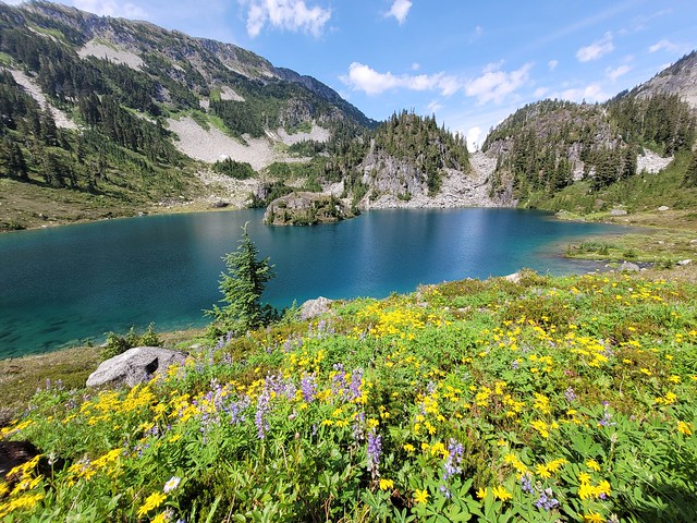
Nine Mile Point Beach and Kunechin Point Campsite are both located in Sechelt Inlet on the Sunshine Coast. There’s a kayak rental place at the end of Sechelt Inlet Road, where you can launch from. It’s ~6km to paddle to Nine Mile Beach and ~10km to paddle to Kunechin Point, but the latter involves crossing the arm of the inlet, which can get windy. Both are beautiful sites and have outhouses, but no bear caches.
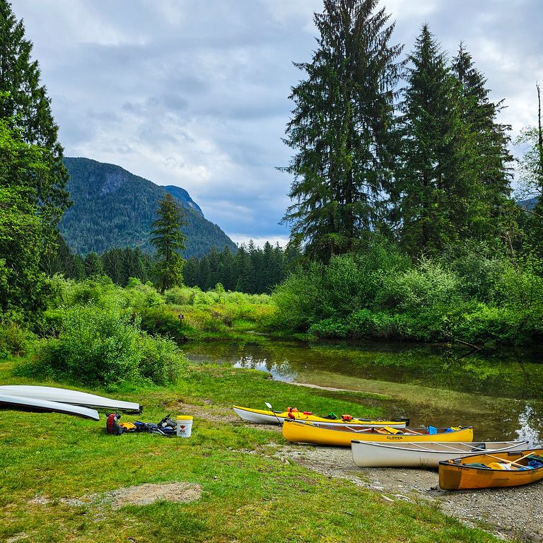
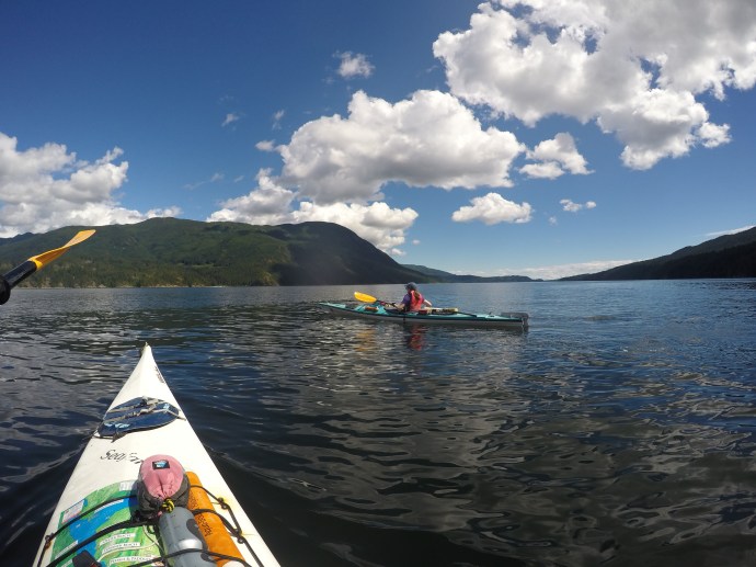
In the last year, along side all our other hobbies, Seth and I decided to start kayaking. We went on our first trip last year over the Canada Day weekend to Sechelt Inlet, and we’re planning a trip to Pender Island for the upcoming Labour Day weekend. I actually wrote this post last year after our trip to Sechelt, but for some reason I never actually got around to posting it (I admit, it takes me a really long time to upload photos and that’s what usually holds up my posts, not the writing). So here’s the post I wrote last year about that trip – hoping to follow it up with a post about our upcoming trip!
I don’t mind carrying a big backpack, but Seth hates it. He likes day hiking and camping, but as soon as you strap a pack on him he loses all interest. So we decided to try a kayaking trip so that we could get into the wilderness without Seth having to lug all his gear with him. I’ve heard Indian Arm is a great place for kayak trips, and it’s right next to Vancouver, but we decided to go a little farther away and started with a 2 night trip in Sechelt Inlet on the Sunshine Coast.
Before I tell you about the trip though, I have to recommend taking the beginner kayaking course from Paddle Canada before you attempt any kayak adventures. Seth and I have both been kayaking before, but I’m so glad we took the introductory course because we were going deep into the wilderness and I’m really glad we learned some basic paddling skills and how to save ourselves in an emergency. We did a 2 day course with West Beach Paddle in White Rock and I would highly recommend them. We’re thinking of going back next year to do the next level because they were so fabulous. We learned a ton of skills and how to rescue each other in the event that we tipped our kayaks. Safety first everyone!
Our first take-away from the course was that we wanted single kayaks. Doubles are so much cheaper, but they also involve a lot of coordination. Me and Seth are really different people and I have a bit of a control complex, so I’m glad we each had our own boat. I think it made for a much more enjoyable trip.
We took the ferry over to the Sunshine Coast early on Saturday morning and drove straight to Sechelt to get our kayak rentals. I was a little concerned about getting all our gear in the kayak, but those things are surprisingly large and we even had extra space in the compartments. It did take a little bit of coordination and jigsaw skills to make everything fit though, I’d recommend many small bags, instead of few big ones. The hardest thing to fit in was our 20L water jug because we brought all our water with us (although we didn’t even use half of the water we brought).
It was overcast and a little rainy when we started, but fortunately the wind was at our backs so we didn’t have too hard a go. Sechelt Inlet is really interesting because it’s only connected to the ocean through one small channel, so you’d think it would be pretty calm in there, but they can actually get some pretty strong headwinds up the channel. There’s also a ton of campsites in the inlet, but we didn’t want to push ourselves too far on our first trip, so we chose Nine Mile Beach as our camping destination since it was only about a 2 hour paddle.
We had a pretty leisurely trip out and stopped at Oyster Beach for our lunch. Nine Mile Beach is the biggest campsite I believe, which is why we picked it, but everyone else seemed to have the same idea and it was quite busy, so I’d maybe even recommend going for one of the smaller ones. I assumed they’d be full since they were so small, but they were actually empty. Halfway Beach is across the inlet from Nine Mile Beach and it is about the same size, but there were definitely less people staying there because it can be a lot of work crossing the inlet depending on the weather.
No fear though, we managed to get a great site at Nine Mile Beach! Most of the campsites are back in the woods, but we went down to the far end of the beach where there were less crowds and managed to find a small site at the very end just big enough for our tent and gear, with a great view of the beach. So we hauled our kayaks up above the high water line and set up camp.
The sun never really managed to come out on Saturday, but it did stop raining before we got to the beach and we spent the rest of the day chilling. I read about half a book and Seth (the biologist) had a great time exploring the low tide and flipping over rocks. I expected to see wildlife while we were out there, but I was surprised by just how much wildlife we saw! It was like a nature zoo! While we were eating dinner the birds gave us a great show. There were two seagulls that were hanging around digging up shellfish (cockles according to Seth) and they kept digging them out of the sand and then flying up high to drop them on the rocks to get to the meat inside. Plus, two black oyster catchers also showed up looking for mussels for supper, which thrilled Seth because they are the birds he is studying for his Masters and he doesn’t get that many opportunities to see them in the wild.
The highlight though didn’t come until nighttime. We heard some rumours you could see bio-luminescence in the water in Sechelt Inlet and our neighbour gave us a tip that you have to actually move to water to see it (we never would have figured this out ourselves). So we got up at 2am and fortunately the wind had totally died off and the water was very still, so we moved our paddles through the water and sure enough it totally lit up with glowing organisms! It was very cool! I was tempted to go swimming in it, but it was just too cold.
The weather cleared up a lot for us on Day 2 and the sun came out! There was still quite a bit of wind when we took off in the morning, but again, it was at our backs. Sechelt inlet has 2 side channels, Salmon Inlet and Narrows Inlet. Our main goal of the trip was to cross Salmon Inlet and visit Kunechin Islets and Kunechin Point. On a map it doesn’t look that intense, but it actually is a fair paddle to cross any of the inlets. It wasn’t bad on the way over with the wind at our backs, but I was a little nervous about coming back.
We wanted to visit Kunechin Islets because they are a protected seabird sanctuary and Seth wanted to see some seabirds. There weren’t actually that many birds around, but we definitely weren’t disappointed. We saw several eagles in and around the islet, as well as a half dozen oyster catchers (and lots of seagulls). We’re probably a bit partial to oyster catchers since Seth’s been studying them for years, but they really are precious! They sound like squeak toys and we enjoyed watching them.
The highlight for me though was the seal colony! Seth counted about 65 seals sunbathing on the rock when we approached. We tried to stay far enough away from the seals to not bother them, but most of them abandoned the rock into the water as soon as they saw us approaching (do feel a bit bad about this, but we really didn’t get that close). They were funny though because they all just watched us from the water with their little heads poking up. It was hilarious, but also a little foreboding because of the sheer number of them!
We had lunch on Kunechin point, which in my opinion had the best view and campsite. It’s located a little bit up on a hill and looks up both Salmon Inlet and Sechelt Inlet. It was empty when we were there, but there’s only 2 campsites there and some kayakers who were departing when we arrived informed us it had been totally full the previous night. I kind of wish we’d stayed there, but there’s very little beach at this campsite, so Seth preferred Nine Mile Beach.
Luckily for us, the wind dropped down entirely after lunch and we decided to paddle across Sechelt Inlet and visit Halfway Beach. The map of Sechelt Inlet is definitely deceiving and the crossing is a lot farther than it looks, but with the wind dropped down, it wasn’t a hard paddle. I really liked Halfway Beach – it has a lot of campsites and it’s brighter than the wooded campsites at Nine Mile Beach (and less busy), but again, Seth still thought that Nine Mile Beach was the best for wildlife. We collected some windfall branches in the forest to take back with us for a campfire (pre-fireban!) because Nine Mile Beach has pretty much been picked dry.
By the time we kayaked back across the inlet one more time it was about 3:30pm and we decided to take it easy for the rest of the evening. I had a really quick dip in the ocean, but I mostly just relaxed and did some reading while Seth did some more beachcombing. We were surprised just before dinner though by a mountain storm.
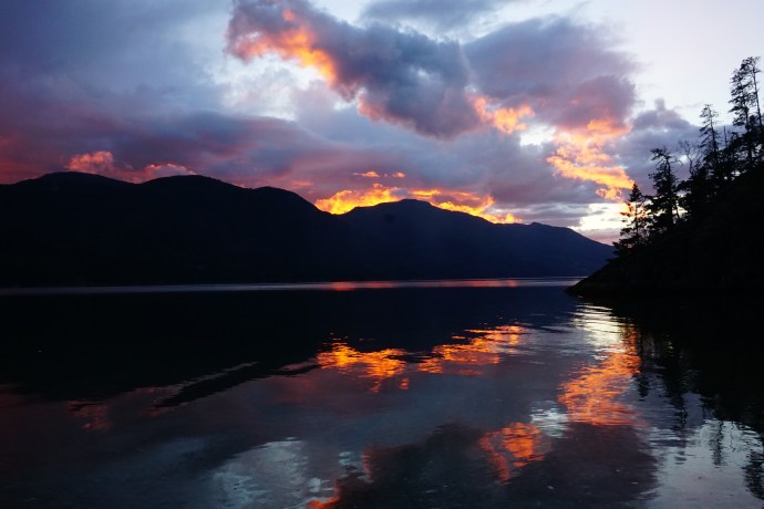
I feel like I’ve gotten a lot more experience with mountain storms this year. They kind of swing in out of nowhere and they don’t really last very long, but they can dump some pretty intense rain on you. We tried to wait it out in the tent, but we were pretty hungry, so we set up a tarp shelter and cooked our dinner while watching the rain clouds move up and down the inlet. We were concerned we weren’t going to get to have our campfire afterall, but the rain finally stopped after about 2 hours and Seth got a lovely campfire going for us while I watched one of the most intense sunsets over the mountains. It was so red it honestly kind of looked like the trees were on fire!
We finished the trip on Monday with a pretty leisurely paddle back to rental company. We got lucky again in that the water was dead calm when we started our kayak back. The wind did start to pick up a little in some sections on the way though and it was a great lesson in how much harder a little headwind can make a paddle. Overall though, nothing too strenuous.
So our first kayak trip was a huge success and I think it’s something we’ll definitely start doing a least once a year. Personally I’m still more of a fan of backpacking, but I really enjoyed getting on the water and trying something new! We definitely saw a lot more wildlife in the kayak and the bio-luminescence was one of the highlights for me!