Widgeon Creek Paddling Trip

I’ve written about Widgeon Creek in the past when I visited as a day trip with my kayak, but this year I made an overnight trip to stay at the campsite! I only paddled the creek for the first time last year, but it’s quickly becoming one of my favourite paddling locations in the lower mainland. It makes for a great day trip or overnight objective. The campsite is large and hiking to the waterfall is a great side mission!

But let’s start from the top. I did this trip with my Girl Guide unit, and I specifically call it a paddling trip because they all travelled there in canoes! I intended to canoe too, but one girl got sick at the last minute, so I ended up taking my kayak since we had an odd number of people. This was my first time doing a trip like this with the girls and we’re lucky to have a very experienced canoeist Guider in the unit to lead the trip.

PSX_20250512_084335
PSX_20250512_083301

While I love my kayak, canoeing does seem a bit more quintessentially Canadian and I was happy to finally learn some canoeing skills. We did two training sessions on Deer Lake before this trip so that the girls could get used to the paddling strokes. Widgeon Creek isn’t a hard objective, but it does require crossing the fast moving Pitt River, and it was important for everyone to feel comfortable and confident paddling. I found canoeing to be a bit harder that kayaking because of the coordination required with your partner. There are more paddling strokes (at least, that’s how it felt) and I initially found in confusing which stroke to use to correctly change direction. But eventually it clicked and I had fun learning a new skill!

If you want to visit Widgeon Creek yourself, you can park at Pitt Lake. The first part of the trip is crossing the Pitt River, after which it’s a 4.5km paddle up the creek to Widgeon Campsite. You can bring your own boat, or once they open for the season, rent right at Pitt Lake. Fortunately, we were able to borrow enough boats for our group, so we were could go a little before rentals opened for the season. We only had a small group of girl guides, but they were enthusiastic and very good spirited!

PSX_20250512_084012
PSX_20250512_083904

We started our paddle early in the morning to avoid the wind and arrived at the campsite in time to set up our tents and eat lunch. The paddle takes ~90 minutes and we made one stop at a pullout along the way for a snack. It rained on us pretty consistently, but no one complained and I noticed that the campsite was considerably less busy than on a sunny day. We were the first to arrive and we were only joined by one other group later in the day.

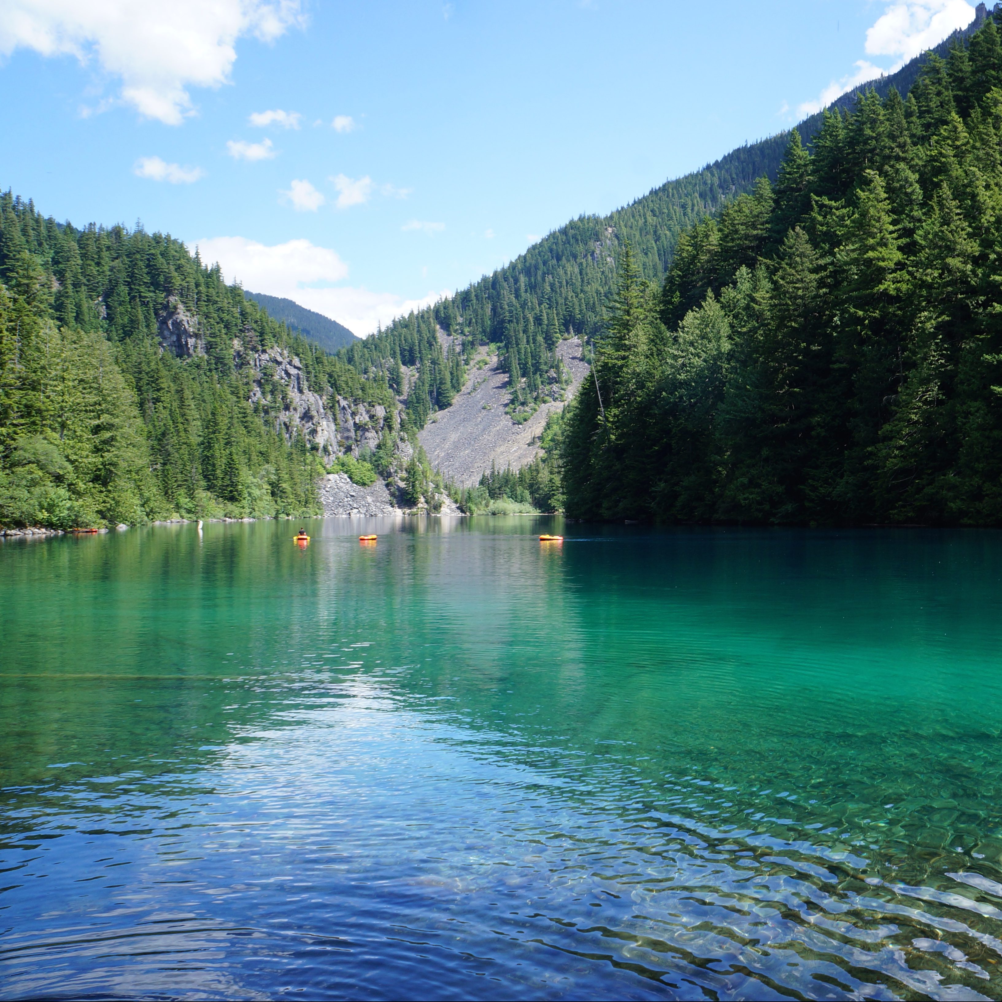
The campsite is fairly large and has lots of bear caches and picnic tables. I imagine it gets busy in the summer, but there are quite a few tent pads and space to spread out. We started by setting up a tarped area to hang out in so that we wouldn’t continue to get wet from the rain. Fortunately, the rain died off after lunch and we opted to hike 6km round trip to Widgeon Falls. It’s a nice trail through the forest that took us around 2 hours, with a snack break to enjoy the view at the falls. Be careful when it’s wet though, the rocks near the waterfall can get very slippery, so we exercised a lot of caution looking for a place to sit have our snack.

PSX_20250512_083539
PSX_20250512_083658

There’s no campfires allowed any time of year at Widgeon Creek, so we returned to the campsite to make dinner and play some games instead. In the morning, we got lucky with nicer weather and we were able to pack down the tents in dry weather. We had a nice paddle back to Pitt Lake, but the wind always comes up in the afternoon and it did pick up just before we crossed the Pitt River at 11:30am. The Pitt River can have a fast moving current, especially in the Spring, around freshet, so we planned accordingly by paddling along the edge of the river, upstream of where we wanted to cross, and then crossing to the boat launch. The current did knock us back a little bit while crossing, but everyone made it without too much issue.

Timing is an important consideration for visiting Widgeon. The creek and the Pitt River are tidally influenced, so they can be a bit high in the spring, but get very low in late summer. I’ve heard that sometimes the creek gets so low you have to walk your boat in places. But it is a very manageable location to visit if you plan around the tides. I’ve been 3 times now and always had a great time! Most of the paddling is located in Widgeon Marsh Regional Park, but the campsite itself is in Pinecone Burke Provincial Park. There’s no permits required to camp there and it is free to visit. It’s a great paddling trip close to Vancouver. We had a great time visiting as an overnight trip!

PSX_20250512_083354
PSX_20250512_083758

Hiking Starvation Lake

I don’t often write about some of the smaller hikes I do, but there are some really nice, lesser known, short hikes out there that can make for a great adventure in the right conditions. Starvation Lake is one of those trails! 

I laughed a bit when I stumbled upon this trail, because the name really doesn’t sell the location. The lake is located not too far out of Squamish, but it’s often overlooked in favour of more ambitious hikes. I stumbled upon it in early July 2024 when I was looking for somewhere to hike that wasn’t still inundated with snow (it was a late snowmelt year). 

20240706_114205
20240706_151139

Starvation Lake is actually a thru-hike trail, measuring ~7km in length. It can be accessed from either Paradise Valley Road or from the Sea to Sky Highway. The lake is located pretty much exactly at the halfway point, so you can choose either end, or park a car on both sides. We opted for the Paradise Valley side of the trail because we didn’t want to park off the highway, but mostly because we also wanted to visit Fergie’s Cafe! 

Fergie’s Cafe is a popular brunch restaurant in Squamish. It’s located on Squamish Valley Road, right before the branch to Paradise Valley Road. It’s nestled along the Cheakamus River and serves the best food! They don’t take reservations, so be prepared for a wait. We managed to get a nice outdoor table where Sadie could “chill”, while we enjoyed our meal. 

20240706_143451
20240706_124749

From Fergie’s, you take the branch on to Paradise Valley Road and drive to the end of the road. Eventually the road turns to gravel for about 400m, so you can either park before the gravel section or drive to the end. If you have the appropriate vehicle, you can continue further along the road by the river, but we opted to just enjoy walking it (to Brandon’s dismay). There’s several FCFS rec campsites along the river, which would make a nice place to camp. 

It’s ~3-3.5km to the lake along fairly well maintained trail. The trail diverges from the river after a kilometre and you start an uphill hike towards the lake. It’s a bit rocky in places, but it flattens out again in the middle of the trail. There’s a final uphill push through the trees and then you end up at the south end of lake. There are a few pocket beaches on the south side, but it’s a small lake, so I recommend continuing around to the other side. There’s a rec site on the north side and there’s more space to have a bit of a beach day. To be clear, there is no beach, it’s just rock, but there’s more space to set up some chairs and relax for a few hours. 

20240706_124803
20240706_143133

It was a hot day, so our main reason for doing this trail was to laze around at the lake. We ended up spending several hours swimming before heading back down to the car. In my opinion, Starvation Lake is the perfect swimming lake! It’s not very big, so it warms up very quickly. I don’t think it’s glacier fed, which also contributes to it being warmer. It only took me about 10 minutes to swim across the lake, which Brandon also did from his floatie. A few other people stopped by while doing the hike or a bike ride and did a quick dip in the lake, but we were the only ones spending extended time there.

I really liked this hike because it’s easy and a great location for swimming. By committing to a 1 hour hike, we managed to avoid the kind of congestion that you find at swimming holes that are directly accessible by car (like Brohm Lake and Murrin Lake). Generally I do prefer to take advantage of the summer season to do bigger hikes, but if you’re looking for a relaxing lake day, this is a great choice! I really enjoyed the experience.

20240706_151625

8 Spring Backpacking Trips near Vancouver

Earlier this season I posted a list of some of my favourite Spring day hikes. As much as I love day hiking, backpacking is my favourite activity and I’m always excited to start camping once the weather gets nice. Spring is tricky for backpacking because the alpine is still full of snow until at least late June, but if you pick the right trail, Spring can be a really nice time for hiking because it’s not too hot and there’s usually not a fire ban in effect. Every year is different and just because a trail is generally snow-free in a previous year, doesn’t mean it will always be snow-free. Make sure to do real time research before heading out to the trail to confirm the conditions. Make sure to Leave No Trace and always be respectful of the land and indigenous territories through which you are hiking. Here’s a few of my favourite Spring backpacking trips!

Lindeman Lake

The blue green hues of Lindeman Lake on a sunny day in summer while people lounge on the water with the mountains in the background in Chilliwack Lake Provincial Park in BC.

Located in Chilliwack Lake Provincial Park, this is a really popular hike. There’s somewhat limited space for tents, so I advise going early in the day or on a weekday if you want one of the tent pads. The hike to Lindeman Lake is less than 2km, but it is quite steep, with 350m of elevation gain. The parking lot is often targeted by thieves, so make sure you don’t leave anything valuable in your car. There is a bear cache and outhouse, but it’s only a throne-style toilet, meaning there are no walls. Due to the high volume of crowds at this location, I think it could use a little TLC from BC Parks. Get a backcountry permit for $5pp per night from camping.bcparks.ca. Campfires are NOT permitted, so enjoy a swim in the clear, but cold, lake instead!

Viewpoint Beach/Half Moon Beach 

A photo overlooking Gold Creek and Golden Ears Mountain from Viewpoint Beach on a sunny day in Golden Ears Provincial Park in BC.

Viewpoint Beach is located very close to the lower mainland, in Golden Ears Provincial Park, and as a result, it’s also very popular. The nice thing about this location is that it’s an easy 4km hike and there’s lots of space for tents. There is an outhouse and bear cache, but the bear cache is severely undersized for the number of visitors, so be prepared to hang your food. Some people cross the river to access Hiker’s Beach, but be careful doing this when the river is running high. Also, be aware there’s no cache or outhouse on that side. If you want to avoid the crowds, you can hike another 6km to Half Moon Beach, but this trail isn’t in great shape, so be prepared for a slower, muddy hike. Get a backcountry permit for $5pp per night from camping.bcparks.ca. Campfires are NOT permitted.

Tikwalus Heritage Trail

A cute red merle Australian Shepherd dog poses on a dirt trail with a large dog backpack, with green forest in the background while hiking on the Tikwalus Heritage Trail in British Columbia, Canada.

The first two trails on this list are very popular, so if you’re looking to avoid the crowds, Tikwalus Heritage Trail is located near the Fraser Canyon on Highway 1. It’s a 6km hike to get to the campsite, but the challenge with this trail is an elevation gain of 750m, so be prepared for a climb! This trail is mostly forested, but has lovely views of the backcountry from the campsite. These are all first-come-first-serve sites, but there’s a fair amount of space and in my experience, it’s not that busy. There is an outhouse and bear cache, but there’s no water source immediately at the campsite, so fill up at the river located 1km before camp. There are no permits for this campsite and campfires are permitted if there’s no fire ban.

Levette Lake/Hut Lake

Two women sit in swimsuits on a dock with a dog, looking out at the forest and blue water of Hut Lake Recreation Site, Northwest of Squamish in British Columbia, Canada.

Levette Lake and Hut Lake are free rec sites located in the backcountry near Squamish, off Paradise Valley Road, but the vibe is very different at each lake. Levette is popular among locals and depending if the road is open, you can generally drive right up to the lake to camp. If you want to avoid the crowds, it’s a 5km hike from Levette Lake to Hut Lake. The trail is along rugged road and some hardcore off-roaders will drive all the way to Hut Lake. There’s not a lot of space for tents at Hut Lake and there’s no bear cache or outhouse, but we were the only people at this campsite when we visited on a weekend in mid-July. It’s a great option for a rainy weekend and we enjoyed swimming in the lake. There’s no permit for this site and campfires are permitted if there’s no fire ban.

Juan de Fuca/West Coast Trail

A photo of Mystic Beach on a sunny, blue sky day with the forested cliffs in the background and the waves washing up on the beach on the Juan de Fuca Marine Trail on Vancouver Island, BC.

The Juan de Fuca Trail is a great option for Spring as it’s located along the coast of Vancouver Island and is open year round. However, it’s closed in 2025 due to damage from winter storms, so I’ve opted to include the West Coast Trail as an alternative. The WCT opens May 1 for the season and is extremely popular, so be prepared to book your permit from Parks Canada when they release in Jan/Feb. Both trails are long, multi-day hikes, though it is possible to do shorter trips along the Juan de Fuca trail. If you’re hiking the Juan de Fuca, backcountry permits are required for $10pp per night from camping.bcparks.ca. Both trails are recognized for their coastal beauty and campfires are permitted when there’s no fire ban.

San Josef Bay/Cape Scott Trail

A photo of San Josef Bay on a cloudy, moody day, with the forest lit by the sun and the waves crashing onto the sand in Cape Scott Provincial Park on Vancouver Island, BC.

Given the challenges with the Juan de Fuca Trail this year, visiting San Josef Bay or Cape Scott on the northern part of Vancouver Island is a great alternative! San Josef Bay is recognized as one of the most beautiful beaches in the world and is only 3km from the trailhead along well maintained trail. If you’re more ambitious, there’s a fully developed trail that travels 25km each way to the historic lighthouse at Cape Scott. This trail is more challenging, but still relatively well maintained, with several campsites on beautiful beaches. All campsites have an outhouse and bear cache and you can get a backcountry permit for $10pp per night from camping.bcparks.ca. Campfires are permitted when there is no fire ban. Be prepared to drive along 65km of gravel road to access the trailhead – any car can make the trip, but be prepared to drive slow.

Sunshine Coast Trail

A female hiker / camper sits on a bench on Manzanita Bluff over looking the trees and blue water of the Salish Sea along the Sunshine Coast Trail in British Columbia, Canada.

The Sunshine Coast Trail is a 180km trail through the wilderness of the upper Sunshine Coast. The entire trail will not be accessible until summer, but there are a few options for Spring hiking in the first 50km of trail between Sarah Point and Powell River. You can do the entire 50km section, or you prioritize one of the shorter trail options, such as Manzanita Bluffs, Appleton Canyon, Rieveley Hut, or Little Sliammon Lake. This is a very well maintained trail with facilities at every site. It is free to hike, but I recommend a donation to qPaws if you’re using the huts. The trailhead at Sarah Point is along rugged road, so I recommend booking a trip with the Sunshine Coast shuttle to access the trailhead. Be aware that not all campsites have a reliable water source (or any water source) and plan accordingly.

Cheakamus Lake

Two backpackers stand and stare at beautiful Cheakamus Lake while hiking to the campsite at Singing Creek on a beautiful, blue sky day with mountains in the background in Garibaldi Provincial Park, BC, Canada.

Cheakamus Lake is a popular campsite near Whistler. I include this option with a caveat to check the trail conditions before going. I’ve hiked the trail in May when it’s been completely clear of snow, but I’ve also had to cancel a June trip when the snowmelt was particularly late. It’s a great option for beginners as it’s a mostly flat trail. There’s two campsites on the trail, the first is a 4km hike from the trailhead and the second is a 7km hike. Reservations are required to stay at these sites and release 4 months in advance of your date from camping.bcparks.ca for $10pp per night. Campfires are NOT permitted, but there is an outhouse and bear cache.