There are lots of popular hikes in Southwest BC, but I would argue that The Chief in Squamish is one of the most iconic. I had experience hiking before I moved to BC, but my practical knowledge was very limited and has grown enormously since I moved here. The only trail I was aware of before moving across the country was the West Coast Trail and I thought it was similar to the East Coast Trail in that it extended down the entire West Coast and could be day hiked in sections like in Newfoundland. I was obviously very wrong and quickly learned that it is actually a remote hike that requires substantial backpacking skills over 7+ days.
Similarly, somehow I heard about The Chief soon after moving here and decided it was a great trail on which to start my west coast hiking adventures. So one sunny day in early June 2014 when my Dad was visiting, we drove out to Squamish to tackle the beast. Looking back on the experience now, it’s a bit comical. We left Vancouver late in the morning and were amazed that we couldn’t find anywhere to park (not a problem in Newfoundland). We ended up finding a place at Shannon Falls (this was before the Sea-to-Sky gondola) and decided to hike up to the First Peak from there. It’s easy to judge people that head blindly into the backcountry with no experience, but that was also how I first started adventuring when I moved here, so I can relate. There’s a very different culture on the East Coast, and while I think East Coaster’s could be a little more prepared, the level of risk associated with hiking in the mountains is a great deal higher on the West Coast.
So I don’t think tackling The Chief as my very first hike was a great idea, but fortunately we didn’t get into any trouble on this hike, or any future hikes, while I was building up my safety and adventure smart knowledge. I remember the hike being very strenuous and it taking us a long time to hike up all the stairs to the top. I remember the rope and chain sections, but I don’t remember ever feeling unsafe on the trail. I bring this up because I recently re-visited this trail in May (8 years after my first visit) to hike to the Second Peak and it brought back a lot of memories that caused me to reflect on this trail and my journey since that very first hike.
The Chief is a hard trail. As my knowledge has grown and I’ve had experiences that required better trip preparedness and wilderness first aid, I’ve become both more safety conscious and risk adverse. It’s easy to walk blindly into situations that we are unprepared for in the wilderness and I’m not surprised to find that The Chief is one of the most visited places by BC Search and Rescue. I can’t quite trust my memory, so perhaps the First Peak is easier than the Second Peak, but returning there this year I felt quite astounded at how challenging The Chief is for how many visitors it receives.
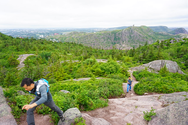
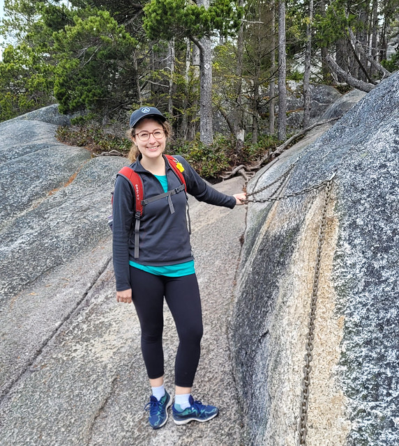
There are many rope climbs, narrow sections with steep drops, a ladder, and steep scrambles over slippery rock. The challenges are exacerbated by the crowds, which create bottlenecks at critical junctions. I’m sure this creates a sense of impatience among hikers that could result in mistakes at challenging locations if people are trying to hurry. I felt like it would be hard to lose the trail (though this does happen), but easy to get an injury. We were able to mostly avoid this with a very early hiking start, but it did make for a slower hike back down on the way out.

So I definitely don’t recommend this hike for everyone. I’d like to return some day for the Third Peak, but after my last visit I can’t say I’m in a huge rush to do it again. Like I said, I’m reluctant to trust my memory, but given my recent experience with the Second Peak, I’m inclined to say that it’s a bit easier going up the First Peak (which I have done twice in the past). All 3 trails start at the same trailhead and it’s an easy flat walk through the walk-in campsites before you hit the stairs. Once you hit the stairs, it’s all uphill for the rest of the hike. It starts with constructed wooden staircase (which on its own is even challenging because the steps are very shallow and steep), but it quickly transitions to stone steps for the rest of the hike.

Approximately 1.1km into the trail, there is a right branch that you can take to get onto the Sea to Sky trail or the branch to Third Peak. I’ve also done the Sea to Sky trail which climbs up to the gondola (you take the gondola down). It’s a very steep trail, but doesn’t feel as perilous as The Chief. I haven’t taken the branch to the Third Peak, but you can access it either through here or continuing on from the Second Peak. The topography looks a bit gentler than the trails to First and Second Peak, so if I do return for this peak, I’ll take that trail instead.
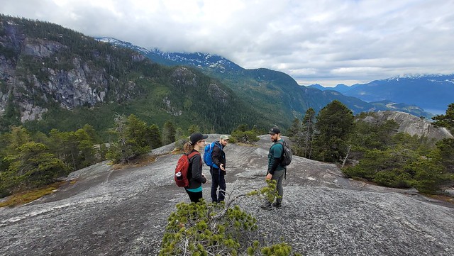
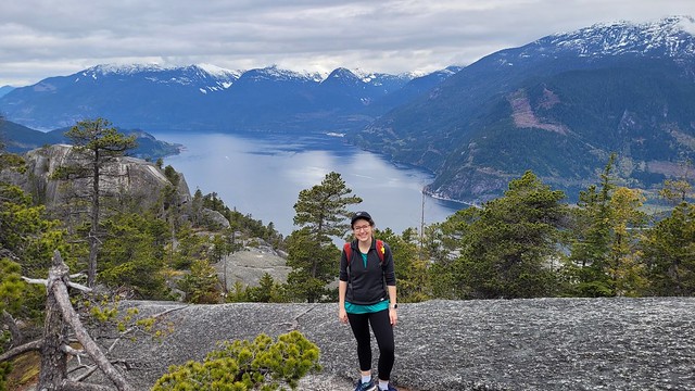
If you continue on past this branch, you’ll hit the second branch to the First and Second Peaks around 1.8km. It’s a shorter hike up to the First Peak – some apps show a trail connected the First Peak to the Second Peak trail, but it’s a climbing route, so do not attempt! In terms of views, both the First and Second Peaks have incredible views. The First Peak is the closest to Howe Sound, so if you want to snag some photos of the vibrant blue water, I’d pick this one. The Second Peak is higher and looks down on the First Peak and provides more of a bird’s eye view of Squamish.

My visit to the Second Peak was a little sentimental because I hiked with Karen and Grant. Karen is my oldest friend (27 years and counting) and they recently moved back to Newfoundland after also spending the last 8 years in Vancouver. The Chief was my first ever hike here and also the last one that I did with Karen and Grant. We’ve all grown a lot since then and even though the climb is still strenuous, the stairs didn’t have us as breathless and panting as they did when we first moved here.
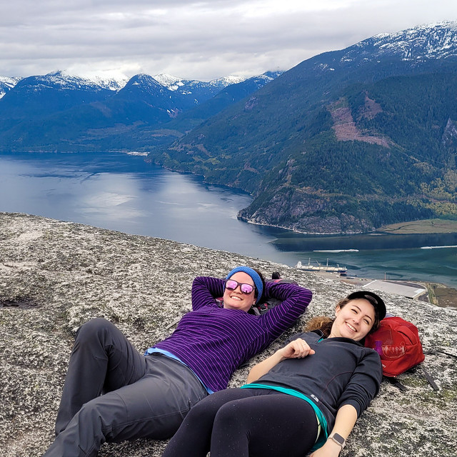
The Second Peak is quite exposed for the last section – there’s no marked trail, you just scramble up the rock until there’s no where higher to go. We had the summit mostly to ourselves due to our early start and we stayed up there for a while snacking and taking some photos before hiking back down to get beers and pizza at Backcountry Brewing. The climb is tiring, but I always find the hike down worse. Take your time and do the rope and ladder sections backwards. There’s one particularly challenging part before the ladder that me and Karen both struggled on because we are shorter. There were more people on the trail on the way back, which slowed us down, but we made sure not to rush on the top section and talked each other through it on the way back. My biggest word of advice would definitely be not to do this hike if it’s rainy as the rock will become a big slip’n’slide.

So that is my assessment of The Chief. I feel really different about it now than I did 8 years ago and I think that comes from better understanding the risks. Sometimes a little knowledge is almost worse than no knowledge because you don’t understand the depth of your unknowns. If you’re new to hiking, I’d recommend taking the Sea-to-Sky gondola instead of hiking The Chief. It has just as incredible (if not better) views as The Chief, but has much easier and well-maintained trails. There’s no shame in doing the easier hike. I just want to present a bit of a different perspective on The Chief because I don’t want people to blindly walk into it the way that I did when I first moved here. I still think it’s a great hike, but something to work your way up to.