Snowshoeing Brockton Point

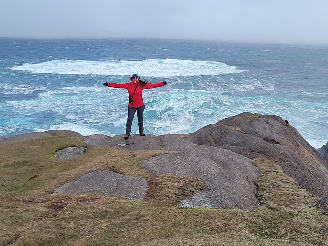
Vancouver got a lot of snow through the Christmas holidays in 2021 and when I returned from my trip to Newfoundland I was excited to get up in the mountains and enjoy it! So the first weekend back in January we woke up super early to be at Mount Seymour when the gate opened at 7am. We’re not quite on the ball enough to get there right on time, but we were able to get parking and hit the hill around sunrise. If you’re visiting these days, you will need to get a parking pass from BC Parks in order to park in the backcountry lot. These are available at https://bcparks.ca/reservations/day-use-passes/ and release at 7am, 2 days in advance of your trip. They are free, but will sell out on the weekends, so make sure to get it right away when it releases.

PSX_20220118_191016

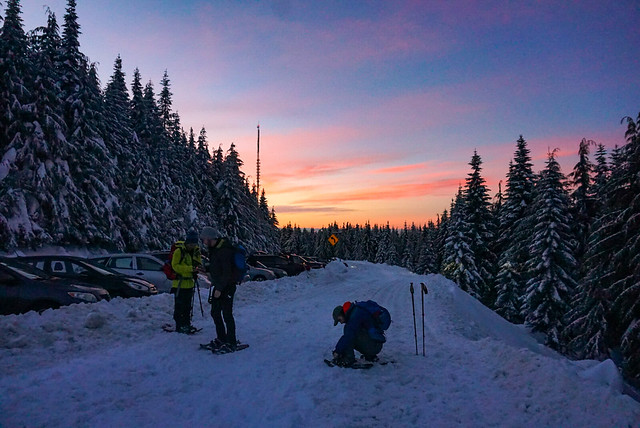
Our desired destination was Pump Peak, which is located past the top of the ski lift, about mid-way to Mount Seymour. I hiked up the ski lift towards Pump Peak once in the summer on my way to Elsay Lake and I snowshoed to Brockton Point the previous winter during my avalanche training course. But it was pouring rain and foggy on that occasion, so I didn’t remember too much about the trek. It’s about 7km out and back to Pump Peak and we were planning to have breakfast at the top. We never ended up making it past Brockton Peak, which was for the best because we later learned that beyond Brockton Peak is avalanche terrain, so it is highly recommended that you take an Avalanche Safety Course and bring proper equipment with you if you are hiking past Brockton.

PSX_20220111_201923

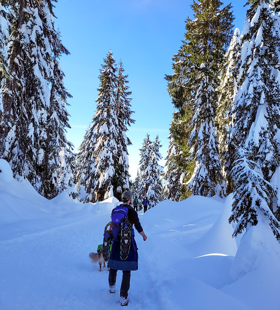
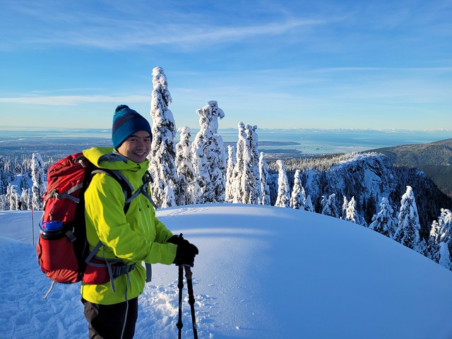
It’s a bit of a slog to snowshoe up to Brockton Point, which is at the top of the ski lift. The snowshoe trail runs parallel to the ski run, but never connects. It’s a wide trail and it’s a pretty steady uphill trek, but boy is it beautiful! The weather blessed us on our visit and it was a gorgeous blue sky day with several inches of fresh powder from the day before. Once you get up to Brockton Point, there are beautiful views in all directions and you can see both out to the backcountry and down to Vancouver. We brought our dog Sadie with us and she had a lot of fun in the snow. However, she is a reactive dog (which basically means she doesn’t like strange dogs approaching her) – this is an on-leash trail, but a lot of dog owners ignore the rule and let their dogs run free, so be aware if off-leash dogs make you or your pup uncomfortable.

PSX_20220117_221628

If you’re looking for an easier day, I recommend stopping at Brockton Point, which is about 4-4.5km round trip from the main ski parking lot, but add another 1km each way from the backcountry parking lot, which is where you’ll be required to park. We started to hike towards Pump Peak, which is easily visible from Brockton Point. The trail descends from Brockton to do a bit of a round about of Pump Peak to climb up from the the back. We started towards it, but as we snowshoed, we checked the time and realized we might not have quite as much time as we needed. We weren’t really that slow, but we weren’t super fast either. We only had a day pass for the morning and Carolyn’s puppy Jasper was home alone, so we wanted to be back down to the car for noon.

20220109_093505

We could have pushed on to Pump Peak, but we would have had to turn around immediately upon getting there, so we decided to stop at a viewpoint near Brockton Point instead (which given the avalanche terrain concerns, was the right choice). We’d all brought our stoves to make breakfast and the views were gorgeous all along the ridge, so we didn’t mind missing out on the peak. Me and Seth made oatmeal, Carolyn and Steve made breakfast sandwiches, and Brandon outshined us all with mountaintop dim sum! It was a warm enough day with the sun shining down on us and we liked having a long relaxing break in the snow instead of rushing up and down to Pump Peak.

DSC00141_1

A few words of advice if you’re visiting Seymour – as I mentioned above, there is now a winter permit system to access the mountain. People have a lot of mixed feelings about this and I think the system has definite pros and cons, but it seems like it’s here to stay, so make sure to get your pass before visiting the mountain. Seymour Resort staff will be checking for permits at the base of the mountain, so you won’t get past the gate without a permit and you won’t get past the snowshoe parking lot without a ski pass. So be prepared for the extra walk up and back to the parking lot. I recommend going early because even with the new system, as this is a very popular destination and even with the pass, you might get stuck parking very far down the lot (which means more hiking added to your journey).

IMG-20220109-WA0011

A lot of people visit Seymour to hike Dog Mountain, which is an easier trail, but there are a lot of people recreating out to Pump Peak as well. The pass system has thinned out the trails a bit, which is nice, but be prepared to encounter lots of snowshoers, skiers, and dogs. A lot of the trail is multi-use, but there are a few places where it branches and skiers will often take slightly different routes, so my advice as a snowshoer is to follow the trail markers.

20220109_091301

As mentioned, you are entering avalanche terrain if you choose to go all the way to Pump Peak. The trail along the ski resort is in simple terrain, so you’re probably mostly okay without avalanche equipment if you’re only going to Brockton Point, but eventually you will reach a sign with the avalanche danger rating just before Brockton Point. After this point, you are leaving simple terrain and entering challenging terrain, so make sure you are familiar with avalanche hazards and take the proper equipment with you. See my post on avalanche safety for more details.

DSC00146

But if you’re prepared, Brockton Point/Pump Peak make for a great snowshoe adventure! I still haven’t made it to Pump Peak, which is why I titled this point Brockton Point instead, but whenever I don’t finish a trail, I just say it was because I had to leave something to come back for! So one day I’ll be back to finish this trail for real!

PSX_20220118_204616

ECT Series: Cobblers Path

Cobbler’s Path was one of the first sections of the East Coast Trail I ever did and I kind of forgot about it in my zeal to hike new sections I hadn’t done yet. However, I’m so glad I returned to this trail over the holidays because I remembered very little of it and it’s such a great trail! Cobblers Path is only 5km long and runs from Red Cliff to Outer Cove. There’s a bit of climbing on the Outer Cove side of the trail, but overall, it’s a pretty easy trail that is extremely close to St. John’s.

20211230_114158

My friends Philippa and Justin are avid hikers as well and convinced me and Sean to join them for a hike at the tail end of December. We all met at the parking lot in Red Cliff and started from there. The trailhead has changed in recent years as the area has developed – the old parking lot on Red Cliff Road has been replaced with a new one at Cobblers Crescent. You hike up through the trees from the parking lot to connect with the coastal trail. You can turn right to go down to “Logy Bay Viewpoint”, but it’s a dead-end because one of the crotchety old land owners won’t let the trail pass over the edge of their land, so the association haven’t been able to connect through to the Ocean Sciences Centre and Sugarloaf Path.

received_242633654665921

We opted to just continue on towards Outer Cove. It was a classic Newfoundland weather day when we hiked and we got every season in one day. It was pretty cold when we started and there was a bit of snow down on the trail. We opted to wear studs because it was pretty slippery, but most of the covered tree sections didn’t have any snow. It was overcast when we started and we caught glimpses of blue sky overhead as the day progressed. The trail passes by some old graffitied buildings and there is another lookout bunker at Red Cliff that dates back to the war (same as on Sugarloaf and many other sections of the trail). At the same location there’s an excellent view back towards Logy Bay and we had a bit of a photoshoot.

DSC00033

I have to say, I do think the cliffs on Cobblers Path are some of the most iconic on the East Coast Trail. That might sound a bit random, but I say it because they are visible from so many other sections of the trail. Even though I hadn’t done the trail in about 10 years, I can always identify it from other parts of the trail. The cliff-side has a sharp diagonal slope in this section and the stratigraphy of the rock looks almost perpendicular to the ocean.

After Red Cliff, the trail descends towards Shooting Point Cove and Cobblers Brook – this was the only other part of the trail I could remember from my first visit and I swore it was my favourite section of Cobblers Path. You climb down through the forest and then cross a bit of a meadow area before starting to hike back up towards Outer Cove. On this day, it was really windy and the ocean was looking extremely unforgiving. The waves were crashing up onto the rocks and there was so much wind that it was blowing all of the salt water spray up onto the trail. A little cold, but a beautiful section of coastline.

20211230_114409

I would say the section after Shooting Point Cove is the only challenging part of the trail. You immediately start hiking back up through the trees and it’s a bit of a climb until you poke out at the first viewpoint of Torbay Point. The clouds were breaking up more at this point and there was quite a bit of blue sky overhead, so we crossed our fingers that the sun would come out.

20211230_122601

I thought Shooting Point Cove was my favourite part of the trail, but I must have skipped Torbay Point on my first visit because that quickly replaced Shooting Point as my favourite and I’m sure I would have remembered it. Philippa and Justin didn’t have time to go down the point because they had a scheduled pick-up, but me and Sean had lots of time to kill, so we said goodbye and hurried down the trail.

received_1000275493857678

“Hurry” is the key word here because the weather was quickly changing again and despite the recent blue sky, we could see a lot of clouds moving in towards the point. I wanted to get some photos at the end of the point and as I ran down towards it, the wind was so strong it literally brought tears to my eyes and I had to shield my face. We got our shots and then started back up towards the main trail as the clouds blew sideways sleet at us. The weather had majorly deteriorated in a matter of 10 minutes and we hid behind some rocks at the trail junction for shelter. We were pretty hungry (or at least I was) and wanted to eat my lunch before we finished the trail.

20211230_124608(0)

In the time it took me to eat my sandwich, the clouds moved down the coast and the sun finally broke through and completely transformed the landscape. It burned off the rest of the clouds in a matter of minutes and I cursed that I now wanted to take all the same photos again in the improved conditions. I held off though because I did quite like the moody cloudy ones we’d already taken and just snapped a few photos of the sun drenched cliffs instead.

PSX_20220103_162933

It’s only a short walk out from Torbay Point and Philippa mentioned they visit every year just to hike out to the point – so it’s a great alternative if you’re just looking for a short jaunt with epic views. The trail pops back out on Doran’s Lane, which is filled with more crotchety homeowners, so be careful where you park. In the summer you can park on the right side of Doran’s Lane (not the left), but in the winter there’s no parking on either side due to snow clearing. Personally I think this is a bit bogus, but the town asks you park down at Outer Cove Beach instead.

PSX_20220102_233935

In our case, Sean’s family lives in Outer Cove, so we just hoofed it a few extra kilometres to his house and then returned to pick up my car from there. If you don’t want to bring 2 cars or do a return trip, you can also hike back along the highway – it’s quicker that hiking 5k back along the trail, but there’s not much for sidewalks so be cautious. To conclude, I’m thrilled I took the time to return to this trail, it was so much more scenic than I remembered and makes for such a great hike only minutes from my parent’s house! Definitely recommend.

20211230_125143

ECT Series: Beaches Path

2021 was my first Christmas home in Newfoundland since 2018, so I had lots of plans for my visit. Unfortunately they were, of course, all dashed by Omicron, but I still got to spend time with my immediate family and fortunately, the outdoors is always open, so I managed to do a little bit of hiking.

There was some snow when I visited, but pretty much nothing had accumulated yet. I brought my microspikes with me to do some hiking along the ECT, but they were overkill and I ended up just using my mom’s studs. The trail had the lightest dusting of snow and ice, but on the sunny day I hiked there, it made for the most picturesque photos!

PSX_20211224_150351

Beaches is a 7 kilometre trail between Witless Bay and Mobile that is ranked as easy. I only tracked 50metres of elevation gain over the whole thing and it was definitely a nice and simple trail. I went with my mom and it took us about 2.5 hours to hike one way. We started in Witless Bay and arranged to get picked up in Mobile. It’s nice to only have to hike one way, but given the ease of trail and distance, you could hike there and back if you don’t mind committing ~5 hours to the trail.

20211222_104310

I really liked this section of the East Coast Trail. In addition to being an easier trail, it’s incredibly scenic! it was a beautiful blue sky day when we visited and the first half of the trail out of Witless Bay takes you along several different beaches and along a few bluffs and cliff-sides. There are small sections through the woods, but for the most part you are directly along the coastline. The second half of the trail is a bit less scenic and has longer wooded sections, but there is one really nice viewpoint at Herring Cove that is worth walking down to. We still liked the entire trail, but if you only have 1 vehicle and don’t want to hike a full 14km, I would recommend hiking halfway along the Witless Bay side of the trail instead.

PSX_20211222_165918

This entire trail looks out towards the Witless Bay Ecological Reserve. From the Witless Bay side of the trail there’s a nice view of Gull Island (see if you can spot the researchers cabin, Seth has done research here in the past!) and we could see a few puffins flying around from the Mobile side, even though it was winter. I haven’t hiked this trail in the summer, but I suspect there should be good bird-watching and whale-watching along the trail when it’s warmer. If not, it’s totally worth taking a boat tour of the area with either O’Brien’s or Gatheralls. We also spotted a seal hanging out in the water around the halfway point of the trail. This is a common occurrence in Vancouver, but I’ve never seen a seal from shore (and rarely from boat) in Newfoundland, so it was an exciting occasion!

DSC00007

Overall, Beaches Path makes for a great day hike. It’s a good length and the drive from St. John’s is reasonable (~45 minutes). It’s a very scenic trail, particularly on the Witless Bay side and I would love to return on a warm summer day. If you decide to do in the off season, I just recommend bringing some kind of traction (spikes or studs) if there’s any snow or ice down on the trail.

PSX_20211227_003100