Viewpoint Beach Backpacking Trip

I feel like it’s a bit misleading to refer to this trip as a ‘backpacking trip’ – it was only a 30 minute drive from my house and 4km to get to the campsite – but I still lugged a backpack and all my gear out there with me, so it counts!

Like many other locals, I was thrilled to hear that the government would be relaxing some of their coronavirus measures and that BC Parks would be re-opening for camping. I was one of the many hopefuls trying to get campsites when they released on May 25, but alas, I had absolutely no luck, so I was left to research where I could go on a last minute permit.

I went to Viewpoint Beach, which is located in Golden Ears park, that first weekend in June after the campsites opened back up again. I had 2 goals. The first was just to get outside and go camping; I wasn’t too fussy on where as long as I had enough space to set up my tent. The second goal required a bit more thought – I wanted to take my puppy on her first ever camping trip. That’s right, I got a puppy!

20200425_130034

Seth and I have wanted a dog for a long time – like pretty much since we moved to BC – but of course a dog is a lot of work and we didn’t really have the space for one at our old apartment, nor were we ready to commit to the time constraints of a dog. But we recently bought our first home and getting a dog was pretty much our first priority when we got back from New Zealand. I know a lot of people have taken on pet ownership in the recent pandemic. We never intended to get a pandemic puppy, but I can’t deny that the timing worked out perfectly.

We’ve done a lot of dog sitting over the past few years, mostly for Jordie the Australian Shepherd and Alfie the Black Retriever. I love them both and was initially leaning towards getting a golden retriever, but after some research, we decided that a high strung Australian Shepherd was the perfect dog for us. Aussies have a bit of a reputation for being high energy and not great for beginners, but they’re also great hikers, so I was sold. We found a breeder in Keremeos and we were set. We picked out a little red merle puppy, named her Sadie, and brought her home at 8 weeks.

20200606_090801

This was right around the time Coronavirus started to blow up (mid-march). The week before we picked her up we went pandemic shopping at the grocery store and I was so anxious to go get her because I could tell the climate was changing fast and I just wanted her home with us. We drove out to Keremeos on Friday night, picked her up Saturday morning, and then drove straight back home. She was so soft and precious. With the exception of vomiting a WHOPPING 4 TIMES, she slept in our arms almost the whole drive home. I took Monday off to stay home with her and by Tuesday, my work had announced we were going to a “work from home” protocol, so it was about 6 weeks later before we left her home alone for the first time. She’s a lucky pup – it was so much easier to be able to properly care for her as a puppy being home all the time, but it has resulted in a bit of separation anxiety (we think). Me and Seth are very much “her people”, but that’s a story for another time.

Anyways, back to the hike, what I’d intended to write about before going off on this life update. I really want for Sadie to be a hiking dog, but as a puppy, obviously she still has her limits, so I wanted something easy and close to home. We decided to try out Viewpoint Beach in Golden Ears.

20200605_181524

I did this hike once before about 5 years ago, so I kind of knew what to expect, but it seems BC Parks has put a lot of work into the trail since then, so it was a lot different than I remembered. They’ve updated a lot of the signage, upgraded the path to the lower falls, and the bridge that crosses over to Alder Flats (was there even a bridge here before? I always thought there was, but I’d hiked to both Viewpoint Beach and Alder Flats in the past and never saw one before). They’ve also added an outhouse at Viewpoint Beach, so it was more popular than I was anticipating for a rainy forecast, but there were still only 6 groups on the beach in total. Not bad for the first camping weekend after a 3 month quarantine.

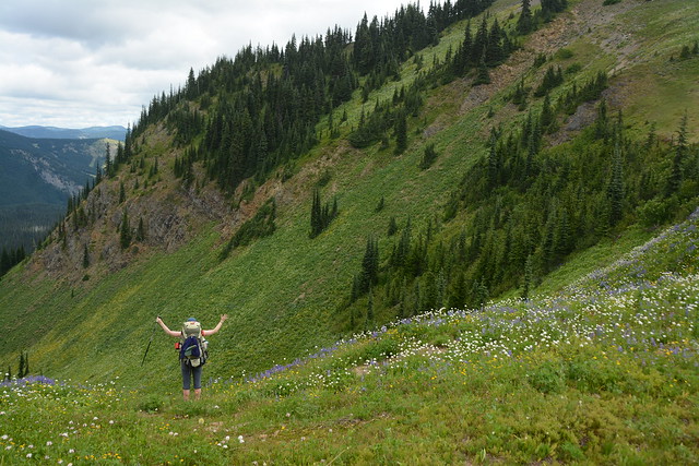
Seth had to work on Saturday, so it was me and Emily that went on the hike. Emily lives on her own in North Van, so we kept her in our bubble throughout the pandemic. We picked up a Modo right after work on Friday and went straight to Golden Ears. We had sandwiches in the parking lot and then set off at around 6pm. Sadie’s been hiking around the tri-cities with us and has hiked up to about 8km to date, so I wasn’t too worried about the flat 4km hike to Viewpoint Beach. It’s always interesting to watch her though – this was our first time with backpacks and I think she could tell it was a slightly different experience than previous hikes.

20200605_192720

She’s a pretty high energy dog. She loves to be outside and if you don’t take her for a walk every day she’ll drive you crazy. It’s funny but even at 4.5 months old, she already has trail preferences. She doesn’t like wide gravel paths, I think she finds them a bit boring, and she seems to enjoy going up or down more than just going along a flat path. The more variety the better, so to date her favourite trails are actually mountain bike trails. We did a lot of exploring in the mountains up behind Port Moody during the pandemic, most of which are mountain bike paths, and she loves nothing more than running up and down those steep, technical trails. So I think I’ll have a pretty rugged hiking companion when she gets older.

It was a pretty easy hike to the beach, we knocked out almost 4.5km in just over an hour, which is actually pretty fast for us. Sadie did well on the hike, but the camping was definitely not without its challenges. Because everything was new, everything was very exciting and it was hard for her to settle down. At home when she gets hyper we just put her in her kennel for a little while and she calms down, but in the wilderness there’s no where to put her and she gets a bit anxious being on the line away from you.

20200605_195244

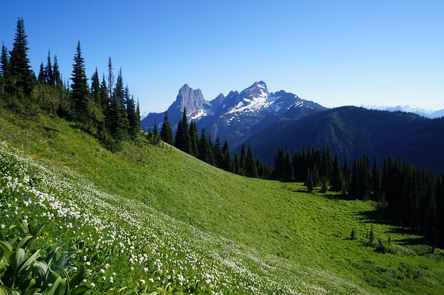
But we were able to get camp set up without too much difficulty. The forecast was calling for rain all weekend, starting around 9pm that night, so we wanted to get everything set up before that happened. There was no sign of rain when we arrived at the beach though. There was blue sky and we had a lovely view looking up at Golden Ears and the surrounding mountains. We set up a tarp for the next morning and a bear cache before settling down on the beach for some tea. Sadie went back and forth between trying to settle next to us and running around the beach chewing as many sticks as she could find.

I was really curious what she’d think about sleeping outside. Having down time was a challenge, but she ended up doing really well in the tent. I bought her a little backcountry dog bed from Ruffwear and she seemed to like it. She settled down there pretty easy and spent the night alternating between her bed and snuggling up between mine and Emily’s heads. I don’t know how much sleep she actually got, but she was quiet until 6am, which is when she normally gets up.

20200605_201226

The rain held off for most of the night, but then it really started to pour around 3am. It wasn’t calling for that much rain, but it was coming down pretty heavy, so I wasn’t really looking forward to the next day. It still sounded like it was raining when I got out of the tent at 6:30am with Sadie, but I quickly discovered it was only the rain from the trees dripping on us and that the rain had actually stopped. So we didn’t end up needing the tarp, but rule number 1 of camping, if you prepare for the rain, it will pass you by, so always prepare!

We had a chill breakfast on the beach and the weather continued to improve, not enough for us to dry the tent or tarp out, but we were able to pack down in dry weather, so no complaints. Had we known the weather would improve, we would have stayed for the day, but since the forecast had been all rain, we hadn’t brought a lunch, so we packed up and hit the trail again by 9am. So we didn’t spend that long in the wilderness, but it was great to finally get out camping and I actually really liked the campsite.

20200606_100125

We had a lovely walk back to the car and decided to try the new (old, but better signed) trail to the lower falls. The first 20 metres of the trail is much improved, but after that it’s a pretty steep, technical hike down to the falls. Nothing we couldn’t handle and it ended up being Sadie’s favourite part of the trail of course.

It’s definitely going to be a very different summer with all the travel restrictions and extra precautions, but I’m so glad the parks have opened back up again because I think so many of us really rely on them to maintain our mental health. Can’t wait to get back on the trail again soon!

Hiking Lightning Lakes

This is the third post in my Manning Park mini-series, so it’s time to talk about one of Manning’s most popular day hikes – Lightning Lakes. Manning Park has 3 campgrounds inside the park: Hampton, Cold Spring, and Lightning Lakes. I’ve camped at Hampton several times and once at Lightning Lakes. Of the 3, Lightning Lakes is definitely the most popular, so you have to be on the ball when booking, which is why I usually end up at Hampton. The nice thing about Manning Park though is that with 3 campgrounds, you don’t have to book a site right when they release, there’s usually something available.

20200508_150708

So in 2017, me and my friends starting making a car camping trip to Manning Park an annual thing. We drive up after work on Friday, do a short hike on Saturday, and then spend the rest of the weekend taking it easy. Usually our trips are all about physical activities, but our manning trip has always been about lazing at the beach, drinking beer, and playing games. After a big breakfast on Saturday morning, we usually relocate to the Lightning Lakes day use area for the rest of the day to hike, go swimming, and have a BBQ. It’s usually too chilly for swimming in the morning, so we’ve gotten in the habit of exploring around the lake.

20200508_150541

Lightning Lakes is as the name suggests, more than 1 lake. The first lake is located at the Day Use area and you can hang out at the picnic tables or rent a boat to explore for the day. There’s a bit of an offshoot from the lake on the other side of the boat launch and then if you follow the river up from the main lake, there’s a second long lake heading into the backcountry. There is a bridge across the river, so you can opt to do just the bottom lake, just the top lake, or both. The first year we’d intended to do both, but the length of the hike is actually a little bit misleading and it is longer than you think, so we ended up just exploring around the first lake. Then our second year we did the opposite and hiked around the back lake. Whatever you choose, make sure you cross the bridge! In my opinion it’s the most scenic part of the lake. There’s very little elevation gain on the hike, so it makes for a nice leisurely walk.

20200508_150628

As I mentioned, you can also rent boats at the lake. I’ve never done this myself because we have a little rubber dinghy that we usually bring, but some time I would like to rent a canoe and go up the river to the end of the lake. Some people find the lake pretty cold for swimming, but we’ve always enjoyed it. There’s also a large dog beach on the east side of the day use area and it’s fun to watch the ground squirrels popping out of their burrows and running around on the grass.

20200508_150640

I definitely prefer Lightning Lakes in the summer, but it does also make for a great snowshoeing location in the winter. Manning is one of my favourite places to snowshoe because unlike the North Shore and the Sea to Sky, it consistently gets snow all winter, so there’s always been fresh powder around when I’ve gone out there. This past winter I went out when my parents were visiting and we snowshoed up to the end of the second lake. We followed the trail on the way up and walked back across the lake. Careful doing this obviously – make sure it’s mid-winter and that’s it’s been cold for a while surrounding your visit.

So if you’re looking for a short, fun, and scenic hike; Lightning Lakes makes for a great pick any time of year!

Skyline II Backpacking Trip

Continuing on with my mini-series about Manning Park, I’m super thrilled to finally write about the Skyline II Trail! After my amazing hike to 3 Brothers, I was inspired to go back to Manning. My goal was to hike the full Heather Trail, but I needed someone to do it with me. This was back in 2017, so I didn’t have as many hiking and backpacking friends as I have now, so that pretty much left Carolyn and Brandon because Seth isn’t really a fan of backpacking. I think Carolyn must have been on vacation at the time, but Brandon happily agreed to go with me. I wanted to hike from Blackwell Road all the way down to Cayuse Flats, staying overnight at Kicking Horse Campsite and Nicomen Lake. But since this requires two vehicles, we decided to try out the Skyline Trail instead.

The Skyline Trail is located on the other side of the park (basically, the other side of the highway) and continues for 25km to Skagit Valley Provincial Park. Since hiking to Skagit Valley would also require two vehicles, we decided to do a there-and-back-again hike from Strawberry Flats in Manning Park. The Skyline Trail is also well known for its wildflowers, but it doesn’t receive quite as many visitors as the Heather Trail, presumably because of the elevation gain. We wanted to beat the crowds to the campsite, so we decided to take Friday off and head out early.

DSC01154

It was late July and a beautiful blue sky day. We started hiking around noon and our goal was to stay at Mowich Camp, which is located right at the halfway point along the trail: 12.5km. The start of the Skyline II Trail is a bit of a slog. You leave from Strawberry Flats, which is a little way past Lightning Lakes. You can also hike the Skyline I Trail, which leaves directly from Lightning Lakes, but is longer and takes a different route up. On the Skyline II Trail, it’s about 5km to the junction with the Skyline I Trail. There’s not a whole lot to see on the way up – it’s pretty much all uphill in the trees, but they start to thin out near the top and you can catch a glimpse of Snow Camp and Goat Mountain. While it’s not the most interesting section of the trail, I’ve always liked it because it’s not too steep, so it takes about 90 minutes to hike up.

Once you reach the junction though, you are greeted by one of the most beautiful views in the park! From the junction the view completely opens up and you can climb down to this rock viewpoint that looks out over the park, all the way to the distinctive peak of Hozameen Mountain in Washington. The viewpoint isn’t for the faint of heart as there’s a pretty big drop-off, but we loved hanging out there while we ate our lunches.

HOP_5700

After that, it’s back into the trees for one last challenging section. You have to climb back down and up Deception Pass. You head right back into the trees and follow the switchbacks down along the pass before starting to climb back out – I think it’s about another 1-2km, but then you’re home free for the rest of the hike! That’s not to say it’s easy, but it is damn beautiful! Skyline II Trail is what firmly cemented Manning Park as my favourite provincial park and to date, I still consider Skyline II Trail to be my favourite hike in all of BC. Now I still have yet to hike in the Rockies, but until I make it out there, Skyline Trail is definitely holding on to the top spot.

Once you climb out of the pass you quickly realize where the trail takes its name from. The rest of the hike is along the ridgeline looking down over meadows full of wildflowers to the Lightning Lakes Chain Trail, and out towards Hozameen Ridge and Hozameen Mountain. We had picked a dream day to hike the trail. There was absolutely no one on it since it was Friday, it was sunny, and the wildflowers were in peak bloom! I can’t recall exactly how long it took us to get to Mowich Camp, but it wasn’t the fastest. I have a feeling it was somewhere around 6 hours, which is a bit on the slow side for us, but we were constantly stopping to take pictures of the wildflowers and had a long lunch break at the viewpoint. Brandon is pretty silly and I was have a fun time hiking with him – he indulged me by taking lots of Sound of Music inspired photos of me dancing in the wildflowers.

HOP_5815

The big thing to be aware of if you’re camping on the Skyline Trail is the water supply. In hindsight, we were pretty lucky because we weren’t super prepared for it. There’s only one campsite on the entire trail and the water source is pretty small. It’s just one tiny stream that runs through the campsite. We weren’t sure if it was even going to be running, so we kept out eyes open for other water sources along the way. There are a few other streams running by, but it would have been a long walk from the campsite. Fortunately the stream in the campsite hadn’t yet dried up. Our plan had been to bring Brandon’s water filter since it was only a small source, but he forgot it, so we had to make do with the emergency water tabs in my first aid kit. Obviously we could have just boiled the water, which we also did to leave overnight, but the last thing you want after hiking all day is to drink hot water (or worse, no water if the stream was dried up). So plan accordingly if you’re going out there. In future, I would bring extra water with me just in case.

DSC01220

Despite the rest of the trail being breathtakingly gorgeous, Mowich Camp isn’t much to write home about. It’s hidden in the trees, so there’s no viewpoint from the camp. But it still goes down in my memory as one of the more memorable campsites. For the first, and only time, on all of my hikes, we were the only people at the campsite. Manning Park is too far to drive after work and then hike into the camp, so we ended up being the only ones there! It was a weird experience. I’ve camped several times with only a limited number of other people (Juan de Fuca Trail and Ring Lake come to mind), but never as the only people. We took over the whole campsite and picked the best spot to pitch our tent. Brandon set up his hammock across two trees and we set up his bluetooth speaker while we cooked to scare away any animals that might be attracted by the smell. Brandon made chili for supper and had even brought dessert up with him! Overall it was a relaxing evening, except when Brandon left to go get ready for bed and I was left alone in the tent with only the sounds of the forest to keep me company. It’s kind of creepy being the only people around and I was definitely more aware of the potential for animals to wonder into the campsite. We were very careful about keeping all of our smellies away from the tent.

But we weren’t disturbed at all and woke up in the morning to continue our journey. Our plan for day two was to hike along Hozameen Ridge to Monument 74 at the Canada-USA border for a view of Hozameen Mountain. We continued along the Skyline Trail for a little while until we reached the junction for Hozameen. The Skyline II Trail continues down from there all the way to Skagit Valley. I’ve never done that section of the trail, but I have heard there’s more elevation gain to reach the bottom, so it’s not as scenic as the Manning side of the hike. But our destination lay along the ridge. We took the junction onto the Hozameen Ridge Trail, which continues all the way to border, and I suspect onwards past Hozameen Mountain and Ross Lake. I was never able to find a proper map for it, so I’m not really sure. My GPS says the trail ends shortly before the border, but it definitely continues to the monument and beyond.

DSC00958

Hiking along the ridge is pretty easy. It’s mostly flat and you meander back and forth through the trees, catching views on both sides. As you approach the end of the ridge, you start climbing. This is definitely a more challenging section, but as you crest the end of the ridge, you’re rewarded with an unimpeded view straight to Hozameen Mountain. If you’ve ever been to Manning on a clear day, it’s likely you noticed Hozameen Mountain. It’s the biggest mountain in the area, with very distinctive jagged peaks. We decided it was the perfect lunch spot and couldn’t pass up the opportunity to soak in the view while we ate our wraps. While we were eating, we came across our first visitors of the day, three trail runners that were training for Manning’s ultra marathon in August, the Fat Dog 120. They had started running that morning and caught up with us at the half-point of their run (and our 3 day trip). They downed a few gels, snapped some photos of Hozameen, and then took off again while we stared flabbergasted that they’d run the same distance it took us 2 days to traverse in just one morning. I bet we had more fun though.

HOP_5937

Our lunch viewpoint is where it looks like the trail ends on my GPS, from there it’s a steep downhill towards Hozameen. We could see the border monument and trail continuing at the bottom, but I was reluctant to go down there because I didn’t want to have to climb back up again. There was no way Brandon was leaving the last stretch of trail unfinished though and he dragged me down over the side to finish what we started. It is difficult to follow the trail down over the edge and it is pretty steep, so be careful if you’re following this route, but I definitely felt a sense of accomplishment when we reached the monument. It was my first time hiking to a border monument (I’ve since done Monument 78 as well) and we had a lot of fun snapping pictures and dancing around the monument.

I was surprised to learn upon reaching the monument that the entire border is actually clear cut through the park. As we hiked along the ridge, we noticed there was a corridor of clear cut trees, but never considered it was the border. I just assumed there was a transmission line down there. But once you arrive at the monument, it becomes pretty clear that it’s the border. I researched it after the trip and confirmed that it is true. There’s no signage at the monument, but I later learned when I hiked to the PCT monument that the border is also monitored by cameras. There’s a sign at the PCT monument asking you not to moon the border as you are on video! Wish I known this when I was flipping Trump the bird at the monument by Hozameen!

HOP_5979

We continued along the trail a little bit further to get another view of Hozameen Mountain before finally deciding to turn back. The trail definitely continues on, but it’s hard to judge the distance because mountains as large as Hozameen can be very misleading when guessing distance. All in all we hiked about 15km there and back to the campsite. We didn’t see anyone on the trail on our way back, but upon arriving it was obvious that other people had been busy hiking in all day. Our little solitary campsite was now filed with campers who had driven up in the morning to hike in for one night. It made me glad that we had taken Friday off and had the opportunity to hike the trail on our own, but we made some new friends with some of our fellow campers and swapped stories while teaching them to play exploding kittens.

DSC01079

We’d had two beautiful blue sky days, but the weather was forecasted to change on Sunday. When I hike with Carolyn, we’re always the first people up and on the trail, but when I hike with Brandon, we’re usually the last. Carolyn is a major morning person, while Brandon likes to take his time. I tend more towards being a morning person, but I can swing either way and enjoy sleeping in and taking it easy when I hike with Brandon. So despite being the first people to the campsite, we were among the last to leave. The clouds had finally moved in, but fortunately the rain was staying away. We made better time on the hike out, but we still stopped a lot to take more pictures. Even though I prefer round trip hikes, I find there-and-back-again hikes still look different from both directions and I have a tendency to take all my pictures twice – especially when it’s different weather conditions and all the photos look different anyways.

We stopped again at the big viewpoint for lunch and then pounded the last 5km back down to Strawberry Flats. I can’t remember if it ever did rain on us, which itself suggests that likely it didn’t, or at most was just a bit of drizzle. So even though it was 3 years ago that I hiked the trail, it still stands out in my memory as one of my most memorable backpacking trips and my all time favourite trail!

HOP_6069