South Chilcotin Backpacking Trip – Tyaughton Creek

South Chilcotin Mountains Provincial Park has been on my bucket list for a long time. I’m not really sure why, because no one else really seems to know about it, but it’s been recommended to me several times by various Guiders and I’ve been trying to find the time to visit for years. I think the challenge with this park is that it’s not close enough to Vancouver to visit on a long weekend, and the trails are so remote that you need a longer time period for your trip. Other trips have always seemed to take priority.

I’m so glad I finally got the opportunity to visit, because I really loved this park! I wasn’t supposed to go this year at all, I had actually planned to do a 5-day hike in the Kootenays called the Earl Grey Trail (also very unknown). But as you might be able to guess, I had to cancel that trip because of the raging forest fires all over the province. The western trailhead caught fire before my trip and even though I could have done a modified trip, I was weary of the smoke and evacuation notices. Jasper burned down a few days before I was supposed to go, so I ended up canceling the whole trip the day before I was set to leave. 

The good thing about Chilcotin being on my bucket list for so long was that I already had several trip itineraries in mind. So after we cancelled the trip to the Kootenays, I was able to pivot pretty easily to this trip. The air quality was still relatively good near Vancouver and there weren’t many fires burning along the coast, so we committed to South Chilcotin and packed the car literally an hour later.

20240727_161924
20240727_180814

The trip ended up being just me and Brandon. We were supposed to meet another friend from Calgary, but understandably, she didn’t want to drive across BC. Instead, me and Brandon packed up his car and took off towards Squamish around noon. There’s a few ways to get to Chilcotin – you can go via Lillooet (either through Pemberton or Highway 1), or you can go directly on the Hurley Forest Service Road. It’s ~6 hours through Lillooet and there were several fires burning in that area, so we opted for the Hurley.

Since the Hurley is a forestry road rather than a highway, it has a bit of a reputation. It’s a joke/point of pride to be able to say “I survived the Hurley”. I would have been too nervous to do it in my Hyundai Tucson, but Brandon was thrilled to drive in his 4Runner, and it did save us an hour of driving. The Hurley is accessed by driving Pemberton Meadows Road across the river and then branching off. There’s a sign at the start of the road that indicates it’s a 4×4 road, but in reality, most cars can handle this road.

It’s a little rough as you climb up the mountainside, but you can travel on it in pretty much any car if you go slow enough. I definitely would have been fine in my Tucson and we even saw Tesla’s and sports cars up there. The Semaphore Lakes trailhead is located at the top of the mountain. It’s a really popular hike, so a lot of people use the road to access that trail. Once you get to the top, the road is pretty flat and maintained all the way to Gold Bridge. So it was a much less scary experience than I anticipated!

20240727_183721

Since this was a last minute trip, we didn’t have any bookings and planned to make use of one of the free BC Rec Sites for our first night. There’s a site right on Tyaughton Lake called Friburg Rec Site. It’s not very nice. It’s basically just a parking lot with room for a few tents, but it was fine for a night. I think it used to be nicer, but the nearby residents complained and they changed the campsite to day use only, leaving only the parking lot for camping now.

There’s a vibrant mountain biking and ski community in Chilcotin that I think is worth explaining in order to really understand the park. Like I said, the park is super remote and difficult to access. If you want to hike into it, you need quite a bit of time. However, hikers aren’t the primary park users and we encountered very few of them during our six days in the park (we only passed 2 solo female hikers and 1 couple). Mountain biking is the most popular sport in the park during the summer and a lot of them take advantage of an outdoor adventure company called Tyax to execute their trip.

20240728_154539
20240728_102723

Tyax runs a float plane operation out of Tyaughton Lake and flies to 3 different locations in the park (Spruce, Warner, and Lorna Lake). They have a huge lodge located at Tyaughton Lake, as well as 3 luxury wilderness campsites throughout the park. We still didn’t encounter many mountain bikers in the park, but most of the people we met were staying at the Tyax camps. It makes for a much easier trip because then you don’t have to carry a tent, sleeping bag, or pad. Plus, Tyax caters all of your meals, so you pretty much can just travel with a day pack!

In contrast, BC Parks has 7 formal campsites in the park, some of which have outhouses and bear caches, and some of which have nothing. Two of the sites are currently closed, but wilderness camping is allowed in the park. No permits are required to camp in the park and since we also stayed at free campsites, this was essentially a cost-free holiday, aside from the gas to drive there.

20240728_140840(0)

We decided to have dinner at Tyax Lodge instead of our campsite. It was a great choice. The lodge is located right on the lake and the restaurant has a huge patio. The food is fantastic, so we were happy to treat ourselves before 6 days of dehydrated food. It was a little hazy from smoke in the area, but there was some rain in the forecast, which we hoped would clear out all the smoke.

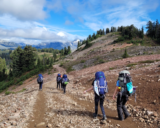
The following day we got up early to start our hike into the park. Hikers and mountain bikers can use the float planes to more easily access the core area of the park, but if you want to hike in, there are several entrances. You can enter through Gunn Creek, Taylor Creek, or Tyaughton Creek. Gunn Creek is currently closed from a forest fire a few years ago. Taylor Creek is accessible in any vehicle and Tyaughton Creek is advertised as 4×4 access, but similar to the Hurley, the road is in pretty good condition and I would do it in my Tucson.

PSX_20240812_214050
20240728_163840

We chose Tyaughton Creek because it’s a shorter distance to enter the park from there, but I think Taylor Creek is the more scenic route. There’s a shorter loop you can do from Taylor Creek, so I opted to save that for a future trip with Seth. Our goal on this trip was to get to the core area of the park as quickly as possible, so we chose Tyaughton.

It’s 16km from the Tyaughton Creek Trailhead to the first campsite (WD Camp). The hike starts with 200m of elevation gain, but after that, the net elevation gain is pretty minimal. We thought it would be a pretty easy hike to the campsite, but it’s actually a tiring trail. It’s not technical, but it climbs up and down from creek to creek over and over again, so we still ended up doing 650m of elevation gain over the entire day.

20240728_123549
20240728_165541

To make matters worse, Brandon seemed to be coming down with a cold and he struggled all day. Fortunately, I was feeling really good, so we pushed through. The trail is mostly in the forest, but it would frequently pop out into meadows where you could get a glimpse of the mountains. There were still some wildflowers in the meadows, but overall they were looking pretty dry.

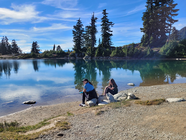
We started the hike around 11am and got to the campsite shortly after 6pm. We only encountered one person on the trail, a hiker heading back to her car. The campsite was completely empty, but was a really nice site. It has a brand new outhouse and bear cache and a great water source. The site was pretty overgrown and you can tell it doesn’t get used much, but there’s room for several tents throughout the meadow. A family of 3 showed up on mountain bikes just before sunset. It was calling for rain overnight, so we got the tent set up and went to bed early. Continue to Part II.

20240728_114149
20240728_145755

Copeland Islands Kayak Trip Part I

I finally crossed off a major bucket list item! Seth and I have been dying to visit Desolation Sound Marine Park since we got our kayaks and have had to cancel the trip 3 times in the last 2 years. I feel like this has been a common theme with a lot of my planned trips since the pandemic, but we finally made it happen over the May Long weekend this year!

20230519_140012

For those who aren’t familiar, Desolation Sound is a marine park north of Powell River on the Sunshine Coast. It’s located at the tip of the Malaspina Peninsula, which is where the northern trailhead is for the Sunshine Coast Trail. So it was a familiar location for me after making 2 trips to Powell River last summer to complete the SCT.

Originally we were focused on visiting Desolation Sound, but as I did some more research, I discovered it’s really easy to tag a second marine park onto the trip and we added Copeland Islands Marine Park to our itinerary as well. Here’s a map of the area:

Desolation Sound

Doing both parks in one visit requires a bit more coordination, but it ended up being easier than I anticipated. Getting to Powell River is always a bit of a pain, but we caught the ferry out of Horseshoe Bay on Thursday evening before the long weekend, following by immediately driving up to Earls Cove to catch the second ferry to Saltery Bay. There’s a provincial campground at Saltery Bay and we stopped to sleep there for the night. We didn’t book in advance since it was still Thursday and we were able to just drive in, but I always recommend getting reservations where possible on the weekends.

20230519_121707

It’s a nice little campground at Mermaid Cove, but we didn’t stay for long and headed straight for Powell River instead. After a quick restock at Canadian Tire for some items we forgot, we drove north to Lund (~30 min drive). Lund is a tiny little community that is easily accessible in any type of vehicle, though once you go north from Lund, you should really have high clearance 4WD. We unloaded our kayaks in Lund and then I called Powell River Taxi for a transfer from Okeover Arm back to Lund. I was expecting to have to wait a while for a car to come up to Lund, but there happened to be a driver nearby, so I rushed the car over to Okeover Arm to park it for our return.

Okeover Arm is on the other side of the Malaspina Peninsula and less than a 10 minute drive from Lund. It’s also a paved road and easily accessible. There’s a public wharf with parking registration if you’re using the wharf (either with a power boat or self-propelled). If you drive a little further past the public wharf, you’ll arrive at Powell River Kayaks and you can rent kayaks from there.

20230519_130817

I didn’t have any trouble finding the parking lot at Okeover, but figuring out how to pay for parking was super confusing. Start by driving down to the dock and at the end of the wharf there is a little shed with parking registration, you take a ticket, leave your money in the envelope, and put it in the drop box. It’s not really that complicated, but I had to tear my car apart looking for a pen to fill out the parking slip, so make sure you bring a pen with you! Parking is only $5 a day, so it’s a very good deal! As for camping permits, they’re also $5 a night, per person, which you can get online, but they don’t start charging until June 1 (in 2023 at least).

But lets get to the fun part, kayaking!

20230519_181723

I returned to Lund around noon and Seth had the kayaks mostly packed. It’s a bit confusing where to launch from because kayaks aren’t allowed on the boat ramp, but there’s a small beach behind the grocery store and we launched from there. Tide was very low, so it was a bit tricky, but there was very little wind, which was lovely!

What I liked about this trip was that, once you launched, you were pretty much immediately in the wilderness. We saw a black oystercatcher within 5 minutes of paddling (special to us because Seth did his M.Sc thesis on them) and more exciting, we saw our first sea lion within 30 minutes of paddling!! We’ve never seen a sea lion from our kayaks before, so it was exciting and a little intimidating. They’re a lot bigger than seals, but fortunately this guy kept his distance. We can’t be sure, but Seth thinks it was a Steller Sea Lion. We ended up seeing 3 in total over the course of the weekend, though we heard them from some of our campsites as well.

20230519_182118

In general, my understanding is that the Copeland Islands are more susceptible to adverse weather conditions than the route that goes through Okeover Inlet because it’s not sheltered and can get a lot windier. Our experience with wind was that it’s definitely calmer in Okeover Inlet, but that Okeover can get some pretty strong currents depending which way the tide is flowing up the inlet. Timing is really important, so give special consideration to the tides and wind when selecting your route. If windy, I’d stick with Okeover, but leave when the tide is going out.

Fortunately there was very little wind along the Copeland Islands when we visited, so we had a really nice paddle through the marine park. We followed the coast until we hit the islands and then immediately crossed over to paddle along the islands. Our experience with the marine parks was that it’s really important to pay attention to the tides. At high tide, there’s not a lot of beaches to land on and some of the campsites can even be tricky to get to; but at low tide, there are a lot more beaches and potential places to explore. The difference between low and high tide on our trip was 4.5m! So the difference can be quite extreme.

20230519_161319

Because the tide was very low when we started paddling, we took a break pretty early after arriving at the islands to eat our lunch on one of the beaches. The beach was absolutely covered in oysters! You are allowed to harvest them with a fishing license, which would have been amazing, but there was a red tide warning in effect, which makes it very dangerous to eat any shellfish, so we just enjoyed with our eyes.

Low tide exposes a lot more islands and we had fun paddling up to the campsites. We were moving pretty slow on Day 1 because of all the provisions we had packed into our kayaks. There wouldn’t be any freshwater sources on our entire 4 day trip, so we had about 35L of water (or 70 pounds) between our two kayaks, plus food and camping equipment! So I definitely felt sluggish on the first day, but it encouraged us to drink a lot of water. It was very hot (high 20’s), so this was probably a good thing!

20230519_163821

The first campsite is Middle Copeland Island. This campground is pretty exposed and while it has several tent pads, there’s not a lot of shade. I’d read online that North Copeland Island was nicer, so that was our final destination for Day 1. I don’t think anyone camped at the Middle Island that night, but there were several groups at the North Island. Fortunately there’s a lot of tent pads, so it didn’t feel crowded at all.

We saw some kayaks landing at the south beach on the Island as we approached. There’s two access points, so we decided to go around to the north beach to land our kayaks. Unfortunately we didn’t realize that with the low tide, the cluster of islands around North Copeland all become one big island, so we had to paddle around all of them and weave our way into the beach. There’s 3 main sections to the island, with a cluster of tent pads on the south, a few on the north, and then a bunch more on the west head. I wanted to camp at the head, but after we landed, we couldn’t find any way to get over there and ended up camping on the north side. It was a great choice as we had more shade and an incredible view! Plus all the other kayaks camped on the south side, so we had it all to ourselves. A motorboat landed on the head later in the evening and dropped off a few families, so I think that’s the only real way to access that area unless you land your kayak on the rocks.

20230519_202255

Unloading at low tide was a bit of a pain in the ass though. The beach was huge, so it took us a few trips to move all our gear up to the island and then we found one small grassy landing to store our kayaks. But overall, I loved North Copeland Island! I think it may be my favourite site on the trip. We arrived around 2:30pm after ~10km of paddling, so we had lots of time to enjoy and explore the island. I set up my hammock and watched as the tide started to come in. Once it got high enough, I decided to go for a swim and was shocked by how warm the water was! It was still only May, but after 2 weeks of consistently hot weather, it was incredibly warm and very comfortable for swimming. It honestly felt like it was mid-summer! Since visiting, I did a bit more research and apparently Desolation Sound gets some of the warmest water north of Mexico! Not sure if I believe that or not, but the evidence pointed to yes.

PSX_20230525_214202

I’m honestly not sure how we passed so much time on this trip. I didn’t really do anything on the island besides swim and lounge around. I didn’t read at all, but I was totally content to just sit in my chair or lie in my hammock and watch nature. It’s weirdly compelling to slowly watch the tide come up and we had a friendly seal hanging around all day. Seth did some exploring on the beach and we generally just took it easy, which was lovely.

The island itself is pretty interesting. It’s a decent size, but a lot of it isn’t really accessible to explore. From our tent pad, we could climb up to the top of the island and we spent most of golden hour up there enjoying the view. Before sunset, we decided we would go for a sunset paddle and since the tide was now so high, we were able to easily launch the kayaks. It was the nicest sunset of the trip and the water was dead calm, so we enjoyed paddling around for a half hour before heading to bed. It stayed warm into the evening and because we were so low in elevation, we slept with the fly off the tent to enjoy the view and the stars. The wind picked up a bit overnight, but it was a great first day of the trip! Check back for Part II.

PSX_20230529_083038

Elfin Lakes Trex Backpacking Trip

Am I really going to write yet another post about Elfin Lakes? My blog, my rules, so yes I am.

I always say that the Skyline II Trail in Manning Park is my favourite hike, but I might have to eventually cede the number one spot to Elfin Lakes because I never get tired of visiting. I’ve been in Autumn, I’ve been in Winter, I’ve backpacked to Opal Cone, I’ve backpacked to Mamquam Lake. It’s not even my first time going with Guide Girls. The first time I went with girl guides, I accompanied a group from the North Shore as a back-up guider. This time, I took my own troop for a one night trip in late September. But it’s always interesting no matter when you go because the weather makes it a different experience every time!

20220924_132643

Both of my trips with girl guides took place on the last weekend in September, but the first trip dumped about 15cm of snow on us, while this trip was sunny and warm enough for shorts! Trex is a special ops unit in Guiding that only does outdoor adventure (as opposed to the full program). I’ve wanted a trex unit for years, so I finally started my own in New West last year and we focused on a backpacking series for our first year. We hiked to Viewpoint Beach in Golden Ears in June, 3 Brothers Mountain in Manning Park in August, and Elfin Lakes in Garibaldi Park in September to finish the series.

It was the longest distance they had done carrying their backpacks, but they did very well. It was pretty cloudy and chilly when we started, but we made good time going up towards the Red Heather Hut. We’d been warned of bears by the park rangers, so we made sure to be loud on the way up and didn’t see any, but some of the trex were really nervous about it.

20220924_135342

We stopped for a nice hot lunch at the hut before continuing on to the lake. From there things got interesting. The trail branches when you leave the hut, with the mountain bike trail on top and the hiking trail below it. We immediately ran into a mama bear with cubs, but you’re probably not surprised to hear that bears are even more afraid of a noisy group of 10 girls than we were of it, so they quickly scampered. They were the only bears we saw on the way up, but we saw a lot more coming back down and I think our final bear count at the end of the weekend was 10 bears! Definitely a record for me. They weren’t interested in people at all though and were only interested in bulking up on the late season berries.

20220924_160510

I love the hike from Red Heather Hut to Elfin Lakes. It’s so scenic as you traverse up and over the ridge. Trex enjoyed it too and they made really good time to the hut. The sleeping hut is still closed due to COVID, but there are 50 tent pads you can avail of instead. We set up our tents and had lots of time to relax and soak in the views. We had an earlier supper so that we could watch the sunset over the lake.

I don’t really plan any activities once we’ve arrived because it usually takes most of the day to get there, set up camp, and eat. But I decided to run a little workshop on star photography for anyone who was interested, which was everyone! I love the long days in the summer, but one of my favourite parts of the diminishing light is not having to stay up late to watch the stars. I lugged my tripod up and we went up on the hill overlooking the lake to try our luck. Fortunately it was a clear night and the moon was no where to be seen, so it was a great opportunity.

20220924_185142

Very shortly after we started (I hadn’t even set up the tripod yet), trex started freaking out when a series of lights started flashing across the sky! They were even more concerned when I didn’t know what it was. It was super creepy and felt very end-of-days when you’re not expecting it. It was a series of lights that were moving in a perfectly straight line across the sky – they were all spaced equidistant and moving at the same pace. They did this for about 5 minutes before the last one finally disappeared. I made a guess that it was a satellite launch and another camper confirmed for us later that it was indeed Starlink! So our timing was excellent. We didn’t get any photos on the camera, but the girls were able to capture a few cell phone pictures of the phenomenon and it was quite a treat to see.

IMG_0013

After that we settled into actual star photography and everyone got really into it for the better part of an hour. We did portraits of everyone with the starscape before turning in for the night. It was a completely clear morning and ended up being a very hot day, so we were driven out of our tents by the sun when it peaked over the mountains and illuminated the campsite. Staying at Elfin is a real treat because it’s definitely one of the most scenic campsites with the 360 degree view of the mountains.

20220924_142857

We had a quick breakfast and packed up our campsites to head back the way we came. We made a slower pace as we came up to the hut because the whole area was crawling with bears and there were a lot of people. One cub had been scared up a tree, which made us nervous because we didn’t know where Mama was, but we passed through without any incident and had a hot lunch in Red Heather Hut before hiking back to the parking lot.

Everyone did really well on the trip, so we treated ourselves to ice cream at Alice & Brohm before heading back to town to conclude the trip. I think this trail lends itself well to a girl guide group because it’s a challenge, but not too hard, and it has lots of tent pads and an amazing view. I just have to work on convincing the girls to go back and stay again in the winter!

20220924_101705