Cape Scott and North Coast Trail: Part V

So I know a 5 part series about the North Coast Trail is probably a little indulgent, but I really love story telling so you’ll just have to bear with me (click here for Part I). As much as I love growing this blog and appreciate all my readers, I do write primarily for myself to document my adventures and give myself a writing outlet. So if you’ve made it this far in the series, thanks for sticking along! My subscribers have been increasing with every post, so I assume there are people out there somewhere reading my blogs – if you are I’d love to hear from you in the comments! As far as I know Carolyn and my Dad are my most dedicated readers – Lien pops by when I write about him, Brandon occasionally reads a post, and Seth and Emily never read anything I write. So to the rest of my readers – I appreciate you! If you read my blog for posts about the backcountry and trails in BC, please let me know what you like about them and anything you’d appreciate seeing added. I really am curious and like to encourage others to get out exploring. I see myself as a bit more of a storyteller than as a place to come for information on trails, but I do try and include both.

DSC06346

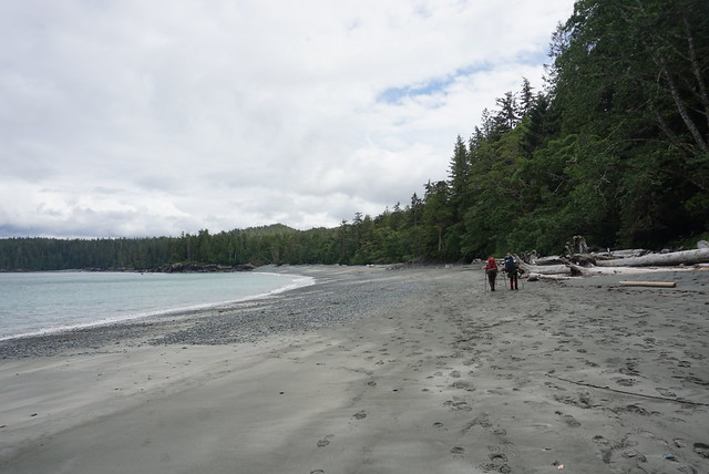
Day 5 is where it started to all go down hill. In my opinion Day 5 was the most beautiful part of the trail and we got excellent weather for it, but the trail got really hard. Our goal for Day 5 was to hike 13km to Nahwitti River. Cape Sutil was located at the 8km mark of the trail, so we figured that would be a good spot to reach for lunch. It was a mix of beaches and inland trails along the way. The morning started out great with some lovely walks along the beach. The trail would pass into the woods for short periods between beaches and nothing was too strenuous, so we were having a good time. Like I said in my previous post, this section of the trail is a lot less windy. The ocean topography must be different because there are no large waves, it’s just gentle beaches with shallow waves coming in. The sun had finally come out and it was really tempting to stop and swim, but we were still making a pretty slow pace so we figured we’d better not.

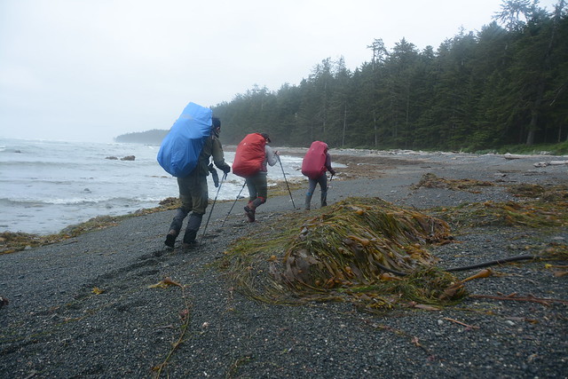
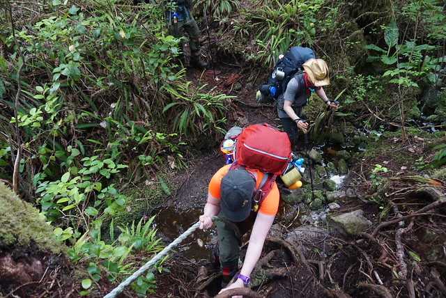
About halfway to Cape Sutil the trail got really difficult. We finished the longer beaches and did an inland trail followed by pocket beaches. All ‘pocket beaches’ really means is that you have to climb up and down a steep, technical trail to get from each small beach to the next across. In my opinion, this was the hardest section of the entire trail. The trail is both steep and has an inordinate number of obstacles along it. Instead of just battling mud and tree roots, there were a lot of large trees and branches we either had to climb over or crawl under. I literally did several parts of the trail on my hands and knees. At one section, I was crawling on my knees to go under a tree, but when I started to try and stand up again, there was a second tree that I hadn’t seen that literally knocked me right back down into the mud on my belly.  In addition, Emily was really frustrated because there were a lot of really tall stumps to climb over and she is so short that she had to climb up most of them on her knees, which is obviously painful on the knees when you’re also wearing a huge pack. This was the one section where being smaller was somewhat beneficial though as I think Lien had a hard time navigating some of the obstacles with his large pack.

DSC06335

Day 5 was another bad day for Emily. I could tell she was starting to lose it from the repetitive obstacles. There was one really hard section up out of the gully from one of the pocket beaches and as she was trying to pull herself up I told her to just yell to express her frustrations and she let out a truly terrifying scream as she hauled herself up. For anyone who knew Emily as a child, we used to call her Shrieky after the character in care bears because she had such a high pitched scream, so you can imagine what that sounded like. Had I not just told her to scream and heard it I definitely would have come running!

When we finally finished the pocket beaches, Emily was ready to stop for lunch, but we all encouraged her to push through the last section to Cape Sutil where we could at least get more water at the same time. Cape Sutil is actually the most northerly point on Vancouver Island, but it’s also a sacred first nations site, so while you can camp at the beach, access to the cape is restricted. So the last section of the trail before the beach was an inland trail bypassing the cape. Fortunately the only obstacle along this trail was mud, which we had long ago made our peace with, so we pushed through faster than expected since it was at least flat. We all celebrated when we finally popped out on the beach, but it was a weary celebration because it was already 3pm and we still had 5km to go. We knew it would be a late night.

DSC06366

The one thing I liked about doing the NCT backwards was that since the water taxi hadn’t started running, there were few people on the trail. However, the taxi had started running the previous day and we’d heard that they were dropping off a whopping 40 people on the first day. Cape Sutil is when we finally encountered the crowds. Everyone seemed to be on the same track – they’d all hiked into Skinner Creek on the first day (9km) and then had hiked 7km to Cape Sutil, where they’d be spending the night. A lot of them were arriving at the same time as us, which wasn’t a great indicator for the condition of the rest of the trail. If I had my time back, I would have done the same thing, added an extra night and camped at Sutil and Skinner Creek. But when I’d planned, hiking 8km followed by 7km just seemed like too short a distance, so we’d instead planned to do the 13km to Nahwitti River, the campsite between the two.

Cape Sutil was beautiful and aside from the crowds, I would have loved to stay, but we already had a water taxi booked for the next afternoon, so we were committed to continuing on. Taking the water taxi at the end was the downside to doing the trail backwards because it left you less flexibility. If we’d been going the other way, we had enough food that we could easily have decided to stay another night if we’d wanted.

DSC06353

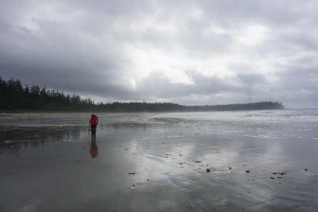
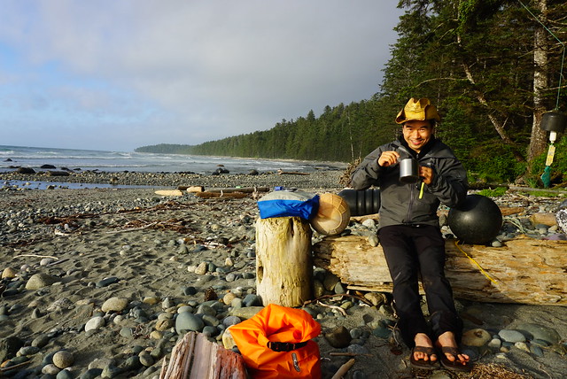
Anyways, we had a late lunch at Cape Sutil and filtered some more drinking water. It was a hot day and we’d all drank a lot already. Unfortunately the filter decided to clog and it took forever to filter, so we didn’t treat quite as much water as we probably should have. It had taken us 5 hours to go 8km and we still had 5km left, so we needed to get going. There’s one tidal section on all of the North Coast Trail and we were approaching it. Shortly after Cape Sutil there’s a pinch point that can only be crossed around low tide. Fortunately, low tide was at 5pm, which is almost exactly when we got there. When we’d checked the tides in the morning we figured we’d probably be getting there around 2pm and if anything we’d have to wait for the tide to drop further, but that obviously ended up not being a problem. Even with the tide at it’s lowest though it was a pretty tight window. We were able to pass through this pretty neat area full of sea stacks, but it was still tight at the very end, so you really do need to get your timing right. There did look to be a high tide trail, but it pretty much involved scaling a vertical cliff with one rope, so I’m glad we didn’t have to do that with our packs on.

But that was the end of the beaches for the day. From there it was 4km of inland trail to the campsite at Nahwitti River. I do think the longer inland trails were slightly easier than the short ones to the pocket beaches, but the length of them really does wear you down. We started the inland section at 5pm and never arrived at Nahwitti River until 8:30pm, so it was a painstakingly slow pace. The inland section starts with a lengthy climb up stairs to the top of the bluff. Poor Lien hates the stairs and he was just so done at this point, I think everyone was. Like I said in one of my previous posts, we had the benefit of all breaking down on different days and Day 5 was my day to play the cheerleader. I was feeling generally tired, but overall it was definitely one of my better days on the trail and I did my best to propel the team through our longest day.

DSC06391

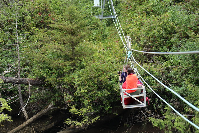
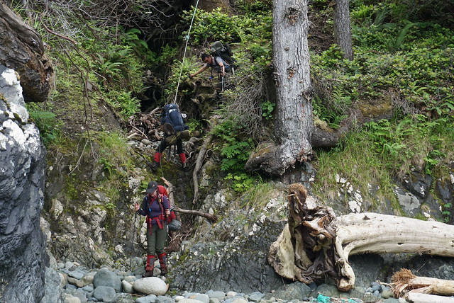
The rest of the trail was long and pretty unremarkable. Fortunately it was more mud obstacles than climbing obstacles, but it was still pretty bad. Unfortunately, Lien drinks like a packhorse and he ran out of water several kilometres in. There were a few water sources marked on the map, so when we did find one, we had to stop and refill again. By the end of the day Lien had drank 4 litres of water! Eventually the path starts to head down and then continues along Nahwitti River. The campsite is just across the river, but it’s not possible to cross it, so we had to follow the river back to our second and final cable car. We were faster on the second cable car and I was thrilled to see a black bear fishing upstream on the river while me and Emily were riding across.

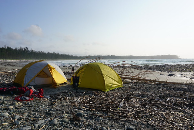
There was one last easier section through the woods before we finally reached the Nahwitti River campsite. Based on the number of people at Cape Sutil, we were wondering what tenting options would be left to us at Nahwitti and we couldn’t believe it when we strolled in to a totally empty campsite. It’s a beautiful site with several tent pads in the woods and room for a few on the beach. Unlike Laura Creek and Irony Creek, the forest is much more airy at this location and you can see the beach from the trees. There was space on the beach, but it was still pretty close to the high tide line, so me and Emily decided to tent in the forest rather than take the risk since there wasn’t enough room for 2 tents. Brandon and Lien slept on the beach, they did have to build up another log wall, but they never got wet.

DSC06411

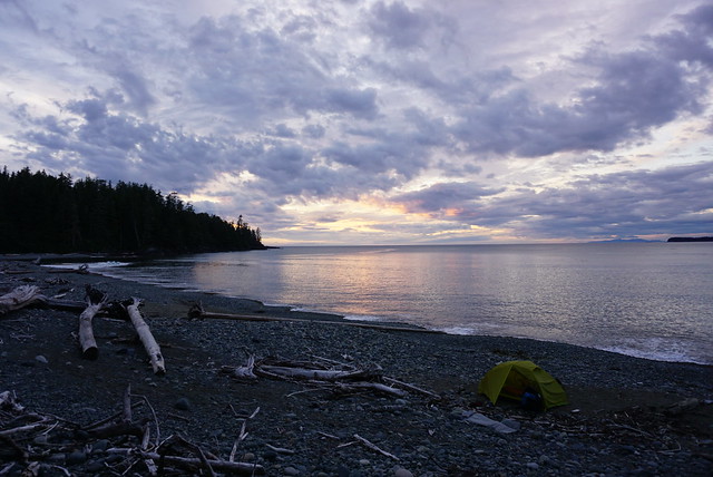
It was 8:30pm when we finally rolled into the camp, so our last night was more about surviving then thriving. The biggest concern was that we still had 11km to go the following day to catch our 4:30pm ferry, so we decided a 5am wakeup call would be required to give us enough time the following day. We skipped the campfire and I put the tent up while Emily immediately started on dinner and Brandon got water. We ate pretty quickly and spent the rest of the evening collecting enough water for the following day. There’s a water source at the Skinner Creek Campsite 2km away, but then there’s nothing for the remaining 9km, so we planned to bring 3 litres each with us.

Unfortunately the water source at Nahwitti River was not great. The river is a lot bigger than any of the other creeks and it flows into the ocean. The tide was up and Brandon commented that the treated water was tasting a little salty and we wondered how much tidal influence the ocean had on the river. Brandon’s assessment of “a little salty” was pretty tame – me and Emily struggled to drink it at all and decided to get more water in the morning when the tide would be on the way out.

Since we had an earlier morning, we hit the sack as early as possible. It was a little creepy in the woods with no one else around and we’d seen a lot of wolf tracks on the beach, so we agreed that everyone would take a bear horn on any nightly pee breaks and that if either tent heard a bear horn, we would all get up to check on it. We’d only been in the tent 10 minutes when we heard a horn from the boys tent. We’d been making fun of Lien the whole trip because he had accidentally set the horn off along the trail at least a dozen times, but we dutifully crawled out of the tent with our bear spray only to hear Brandon hollering up from the beach that “it was an accident! Abort!” We laughed and crawled back into the tent for the rest of the night.

I still have enough material for one more post (Part VI), so tune in for my final entry next week! I’ll finish with this excellent picture of Emily at her wit’s end on the trail:

HOP_4345

Cape Scott and North Coast Trail: Part IV

Check out Part 1, Part 2, and Part 3 to read about our full adventure on the trail.

We were both optimistic and apprehensive about Day 4. We’d had a great evening, but it was probably the worst night sleeping on the trail. The wind did eventually die down but it was super damp at Laura Creek. Everything in the tent that wasn’t in my sleeping bag with me felt somewhat damp and I had a hard time falling asleep because even my pillow felt wet and it kept sticking to my face. Eventually I did drift off, but I think Emily was up for most of the night. We got up to pee at one point and it was absolutely freezing out.

It warmed up around sunrise and it wasn’t too bad when we got up and walked back to the forest to retrieve our stuff from the bear cache. But it started raining lightly and we were feeling a little weary, so we decided to have a tent breakfast. We boiled water leaning out through the vestibule and had our oatmeal in the tent. I’m sure this isn’t the best practice and I wouldn’t do it for a fragrant dinner, but since we were just boiling water, we took the risk. Since we were carrying the tent on the outside of our packs anyways, we packed up from inside the tent and Emily tended to her feet. They were definitely getting worse – her pinky toes looked awful – she’d gotten blisters on both and they’d since popped, leaving an open wound between her toes and a lot of dead skin on the outside of her toe. She also had several other blisters and hot spots so we taped and moleskined as much as we could. She’s a real trooper, I never could have hiked so far with my feet looking like hers did.

HOP_4017

Fortunately the rain moved on when we were finally ready to go. Day 4 was going to be all about beach walking. You’d think that would be easier, but Emily in particular was dreading it because walking along the beach for extended periods of time really wears your feet down, especially if you have to do it for 12km. Walking along the fine sand is difficult because it’s such a hard surface and it’s rough on the soles of your feet, same with big boulders where you have to jump from rock to rock. Cobble has it’s own challenges too, the worst being the medium sized cobble that’s too small to walk from rock to rock, but too large to sink into it. The rocks create a lot of awkward angles on your feet and it gets really tiring. My preferred medium was black sand – it’s not as fine as the golden sand, so it’s a little easier on the feet. I think we encountered pretty much every type of beach surface on Day 4!

I did enjoy the start to the day. My feet were feeling refreshed and we saw lots of wolf tracks running along the beach. We hiked all morning up towards Christiansen Point. The whole time you’re able to look back towards the entire coastline to Cape Scott, which is rewarding when you’ve had the achievement of having hiked that entire distance. But Christiansen Point is the last view of Cape Scott and once you round the bend it’s a new landscape. I did find this to be a bit of a turning point with the waves as well. I guess the currents and winds are different on the other half of the trail and I found, with the exception maybe of Shuttleworth Bight, the waves were softer, particularly on Day 5.

DSC06245

We decided to stop at what we thought was Wolftrack Beach for lunch. Afterwards we realized it wasn’t actually Wolftrack Beach when we went one beach further and found the real Wolftrack Beach, so I guess we just stopped at some beach we didn’t know the name of. I do wish we’d stopped at the actual Wolftrack Beach, which was lovely and sheltered; where we did stop was a bit of a poor choice as we couldn’t find much respite from the wind and it was cold as we sheltered behind some logs at the back of the beach. We were treated to a little show though when a black bear wandered out on to the beach about halfway through our meal. Fortunately it was a positive bear experience. We could tell it was aware of us further down the beach and that it didn’t want to interact with us, so we just chilled and watched on the other side of the beach as we ate. Eventually it finished up on the beach and wandered back into the woods and we continued on our journey.

The weather improved as the day went on, but we started to hit a bit of a wall. As much as Emily thrived on Day 3, she suffered on Day 4. Our feet were all throbbing and our pace slowed down as we trudged across beach after beach. Between beaches we’d pop into the woods for 100 metres or so, but it was never for long and we always found ourselves at the start of a new beach. Emily slowed down as we continued and I found myself starting to become lethargic as well. Emily complained of being nauseous and I was starting to feel a bit lightheaded, which triggered the alarm bells in my head from many years of lifeguarding and first aid training that we were dehydrated. Though we’d been drinking lots of water, we had been hiking exposed on the beach for the entire day. The sun was mostly hiding behind the clouds, but the exposure had finally worn us down. I made us all stop and I mixed up a litre of electrolytes and forced me and Emily to drink a half litre each and we both ate some salty snacks.

DSC06259

I did feel my energy start to bounce back pretty quickly after that. It took a bit longer for Emily, but fortunately we had finally reached a legitimate inland section. We didn’t know if it would be as challenging as the inland section from the day before, but it was only short, so we figured it would be a nice change. Fortunately it wasn’t as bad and we soon found ourselves at our first cable car. The North Coast Trail has 2 cable car crossings located at rivers that are too deep to ford. It’s a pretty simple design – the cable car is attached to a steel cable that it can roll back and forth across and it has a second simple rope pulley system running under that to pull yourself across the river. We had to climb up a big metal structure to get to the first one and then we pulled the cable car across from the other side.

Brandon was the only one with experience using a cable car before, so he instructed me and Emily to load up our backpacks and each take a seat in the car while he held it steady for us. It’s a tiny little metal frame box with two seats facing each other and just enough space for your bags in the middle (barely, say goodbye to any leg room). Brandon warned us to make sure our hands were inside the car when he left go and to always pull away from the pulley to avoid pinching any of our fingers. When he let go we rode off at a good clip to the center of the river and then had to pull ourselves to the other side. It wasn’t too challenging because Lien and Brandon were also pulling from their side, so there was 4 of us to share the load. We offloaded and sent the car back to the guys, holding it from our end while they loaded into the car. We did the same thing for them and helped pull them across once the car lost momentum. I just wish I’d taken the time to dig out my gloves because it is hard on the hands pulling the rope.

IMG_0498

With everyone safety across the river we had about 500 metres left to the beach. It was a pretty muddy section and we all collapsed in the sand when we finally reached Shuttleworth Bight (okay maybe just me). Of course the campsite was located on the total opposite side of the beach, so we had 1 more kilometre to walk across the beach. We’d passed a few people throughout the day that had camped at Irony Creek the previous night and were now heading all the way back to the San Jo parking lot. One family informed us to be careful where we camped because they’d been hit by the high tide the previous night and had gotten wet! We could see lots of campsites along the edge of the beach when we arrived, but we could also see that the high tide line went almost right up to them. I checked the tide charts and high tide was going to be at 10:30pm and would be higher than the previous night, so it didn’t look like a good place to camp.

Brandon went in search of another site and found a small bit of beach right next to the forest tent pads that looked just big enough to fit our tents. There was another camper who had been there the previous night and she came over to chat with us. There’d been 6 groups the previous night and they’d all camped on the beach. While only the one family had gotten wet, the tide had come up super close to all of them and she’d moved her tent to a forest pad for the night. She informed us the spot we were looking at tenting was probably the only beach site left that wouldn’t get wet, so we decided to take our chances since we would be up late enough to keep an eye on the tide and wait for it to change. The 5 guys from Laura Creek showed up a little after us and started setting up on the beach, but after talking to the same camper, decided to move to the forest tent pads as well. So every tent pad ended up being filled and we had the one beach site. Fortunately no one else showed up looking for a site because the rest of the beach sites did indeed get inundated by the tide.

DSC06277

Shuttleworth Bight is a huge white sand beach – Irony Creek is located on the very end and as the only water source, it’s obvious why the campsite was located there. I really liked Irony Creek – it wasn’t as windy and we had arrived before 5pm for once, so we had time to enjoy it properly. Again, we set up the tents and Brandon got a campfire going while I worked on dinner. It was my night and I had made and dehydrated a coconut curry. It didn’t rehydrate as well as I would have liked, but the flavour was really good and it was super filling. We finished dinner by 7pm, which was super early for us, so we had a really low key evening chilling by the fire. One of the guys came to talk to us because he was having nausea and heart pain and he didn’t know what to do about it, so we offered him some peptobismal because we thought it sounded like heartburn and he didn’t know what pepto was! Me and Emily sang him the symptom song and gave him some pepto chews and he said they did make him feel better. I literally never go anywhere without pepto (one time I got it confiscated by a bouncer at a Vegas club because “no pills allowed” lol), but it helps for so many symptoms, so it’s a great one to bring with you.

DSC06268

The main source of entertainment for the evening was watching the tide. It kept sneaking its way closer and closer to us. We were both on the same patch of sand, but Brandon’s tent was the one more at risk, so we built up a little barrier wall out of logs to protect against any rogue waves. There was more than 1 wave that splashed against the barrier, but fortunately the tent never did get hit. By the time the tide finally turned the wet sand line was only a foot away from the vestibule to the tent, so it was definitely the closest I’ve ever camped to a changing tide! We felt really lucky to be able to camp on the beach, but the one downside was the sea ticks. At Guise Beach we’d noticed that along the tide line at night all these gross little sea ticks come out to feast on sea debris. They look like little shrimps but they jump around on the sand. The closer the tide got to us, the closer the sea ticks moved. They were all over Brandon’s tent and they were creeping around in front of mine and Emily’s tent too. Fortunately none got inside the tent, but every time we would open the door we’d give the tent a big shake to dislodge any and then we’d jump in or out as fast as we could to avoid any ticks making their way inside. Once the tide moved back out they went with it, but it was peak tick time when we finally climbed inside the tents for bed.

So overall, despite the challenges with so much beach walking, it was still a good day. We really enjoyed our time at Irony Creek and we were still looking forward to the next two days. Little did we know the trail was about to get even more challenging – but more about that in Part V!

DSC06284

Cape Scott and North Coast Trail: Part III

The Saga continues – here’s Part 1 and Part 2 if you’re joining in the middle.

On Day 3 we finally started the North Coast Trail. As I mentioned before, most people start with the North Coast Trail and continue on to Cape Scott, but because of some conflicts with the water taxi dates due to Covid-19, we decided to do the trail backwards. So instead of starting with a water taxi from Port Hardy to Shushartie Bay, we had already hiked 37km and we still 43km to go. We hiked from Guise Bay to Nissen Bight before lunch and then continued from Nissen to Laura Creek, our first section on the North Coast Trail.

From the end of Nissen Bight, it’s about 5km in the woods, followed by another kilometre along the beach to reach the campsite. Our feet were already aching from pounding across so many beaches, so it actually felt like a bit of a relief to start climbing up into the woods. There was a noticeable change to the conditions of the trail as soon as we entered the forest. It started with a steep climb up towards Nahwitti Cone and then it was 5km of poorly maintained trail and mud.

DSC06187

The North Coast Trail is a pretty bare bones trail, besides keeping the brush at bay, it seems that the trail is left pretty wild and it makes for a very technical hike. There’s a lot of mud to navigate around as well as tons of obstacles from the trees. You’re constantly climbing up and over logs, under branches, and jumping your way around mud pits. The Juan de Fuca was a similar experience for me and Emily, so we didn’t come across anything unexpected, but we definitely forgot just how challenging and slow these kind of hikes can be.

At first the obstacles were a welcome distraction from our aching feet. When you put your brain to work navigating the obstacles, it does distract from your other pains, but the forest paths make for REALLY slow progress and eventually you just get frustrated at how long it takes to make any kind of progress. This was Lien’s first real challenge. He’d never been on a technical coastal trail before and so he really had no frame of reference for what it would be like. When we first switched our plans from Mount Assiniboine to the North Coast Trail, his first response was, “well at least it will be an easier trail!” We all laughed at him and informed him it would actually be a lot harder, but I can see where the misconception comes in and I have made the same assumption in the past. Mountain trails appear to be harder because of the large elevation gain, but coastal trails often still have a ton of elevation gain hidden among the relentless up and down along the coastline, as well as they’re usually a lot more technical.

HOP_3962

There was a marked difference on Day 3 though in that we barely saw any people. We’d started hiking Cape Scott on the weekend, so it had been crawling with people, but it was now Tuesday and so even on our hike to Nissen Bight we didn’t see many people. After Nissen the trail really emptied out. We saw one hiker just as we were starting the climb to Laura Creek – he was returning from an overnight at Irony Creek (that’s a 19km hike!). After that the only other people we saw was one group of guys who were camping at Nissen and had day hiked out to Laura Creek and back. In mine and Emily’s opinion, it’s a waste of time trying to avoid the mud on a trail like the NCT, so we were both pretty muddy and had wet feet by the end of the day. We had wet feet the entire 4 days we hiked the Juan de Fuca, so in our opinion keeping our feet dry until Day 3 had been a pretty big success. But when we passed the guys coming back from Laura Creek and saw their completely mudless legs and boots, we had to conclude that they were clearly witches to stay so dry.

Lien struggled along this section, mostly from the repetitive uphill sections. I started stronger along the wooded stretch, but eventually it really got to me too. I was tracking the hike along my GPS and every 30-60 minutes I’d check in to see how much progress we were making and it was always a mistake. Your location barely moves and it really only serves to de-motivate you. What was more depressing was that I’d read in the trail book that this was one of the easier wooded sections of the trail, so it made me really apprehensive about what was to come later. So much of making it through these long hikes is mental and often you just have to focus on making it through one part at a time.

DSC06214

Unlike the rest of us though, Day 3 was where Emily peaked. She had a rough Day 2, but she was in her element on this section. Despite her blistered feet, she was our cheerleader for the day and led us through the worst of it. One of the real saving graces of having 4 people in your group is that we didn’t all fall apart at the same time. There was always someone who was struggling, but when that happened, someone else would always step up to help motivate the group. The constant uphill was Lien’s mental block for the day, so we all cheered when we finally started heading downhill in earnest and could see the beach peaking out through the trees. We still had 1 more kilometre to go across the beach, which is it’s own kind of hell at the end of a long day, but at least you make a faster pace.

There was some confusion about where the water source was, so we spent a bit of time poking around for it at the end of the beach, before a closer read revealed that it was actually located right at the campsite. I’d read Laura Creek only had 4 tent pads, so despite seeing no one else on the trail, I was still a little concerned about availability. Me and Emily were anxious to get off our weary feet, so we took off towards the campsite. Fortunately there was only 1 other group of 5 guys at the campsite and they were only using 2 of the tent pads, so there were 2 more left for us.

DSC06213

I have to admit, as relieved as I was to sit down, the tent pads were a little gloomy after the beautiful campsite the previous night. The trees were extremely thick and didn’t let a lot of light in, plus everything felt damp. Fortunately Brandon is much more determined than me or Emily and when he showed up, he dropped off his backpack and declared there was no way we were camping in the woods and he would find us a spot on the beach.

There’s no where to camp on the beach near the tent pads because it’s a steep cobble beach, but if you continue another 200m to the water source, Laura Creek, there’s a small sandy beach with enough room for 3 tents. There was one couple set up there already and they kindly moved their tent to the side so that we could set up our two tents next to them. It was extremely windy, but a definite improvement over the wooded tent pads! So much thanks to Brandon for that!

We put up the tents as fast as we could and chucked all our gear inside to keep them from blowing away. We changed right away because it was cool with the wind in our sweaty clothes. Once I bundled up with a few layers though, I forgot about the wind and was thrilled when the sun finally came out for the first time since we’d started the trail!

DSC06225

The weather on these trails really is wild – it’d been overcast most of the day, but within a half hour the wind completely blew the clouds away and we found ourselves with a gorgeous sunny beach view – so that helped with the chill as well. It was somewhere around 7pm at this point. It ended up taking us about 4 hours to go the 6km from Nissen to Laura, so we knew we were in for some longer days.

By Day 3 we’d started to get into a bit of a routine. Lien got water from the creek to start filtering, Brandon started working on getting a fire going, and me and Emily started boiling water for hot drinks/soup and started making dinner. Emily was the chef for day 3 and served us a cheesy pasta that we’d made from a backpacking website. It was vegan so it used coconut milk powder and nutritional yeast to get the creamy cheesy flavour – it was my first time using either ingredient and it was actually pretty good.

The only downside to our beach campsite was that it was a 200m walk back to the outhouse and bear cache, but definitely still worth it and we ended up having a great night relaxing on the beach by our fire. Laura Creek definitely had the best sunset of the trip; when the clouds cleared out we had an excellent view of the sun as it dipped below the horizon and filled the sky with its orange-yellow glow. We were zonked from the long hike, but relieved that our biggest day was now behind us. Over the next 3 days we’d be averaging about 12km a day, so we were optimistic that though the hiking wouldn’t get easier, the days would at least get shorter. It was an incorrect assumption, but more on that in the next entry, Part IV!

DSC06239