Woohoo! We made it to my final post! If you’re just joining us, start at Part 1.
After a week on the trail, we finally reached our final day. Day 5 was really long and tiring and unfortunately, we never really had enough time to recover. We’d strolled into the campsite at 8:30pm the previous night and had to get up at 5am to give ourselves enough time to catch the water taxi. Because we never really had any down time, we all had trouble falling asleep and it was a really restless night. We woke up feeling unrested for the long hike ahead of us. We’d collected water the previous night, but it was salty tasting and not thirst quenching, so I went back to the river at low tide to collect more. When I saw how different the river looked from high tide to low tide, there was no question the river was tidally influenced and that we’d been straight up drinking filtered salt water the night before. The river had shrunk to about a 10th of the size of the previous night and instead of a huge river, it was now a tiny creek flowing down. I collected a little bit of water from it, but the whole area is covered with salt water debris, so despite the fact that it was definitely freshwater flowing down, it still tasted brackish from flowing across the tidal riverbed.
I drank a big mug of hot chocolate for breakfast because it was the only way I could stomach the water and we concluded that we would have to get water at Skinner Creek 2km later. It wasn’t ideal because it would blow a lot of our critical time filtering 3 litres each, but obviously we had no choice as we couldn’t be drinking salt water all day. We learned later that you’re supposed to get your water at the cable car crossing when you camp at Nahwitti River. I read the entire North Coast Trail guidebook and knew about pretty much everything else we encountered on the trail, so I’m really not sure how I missed this.
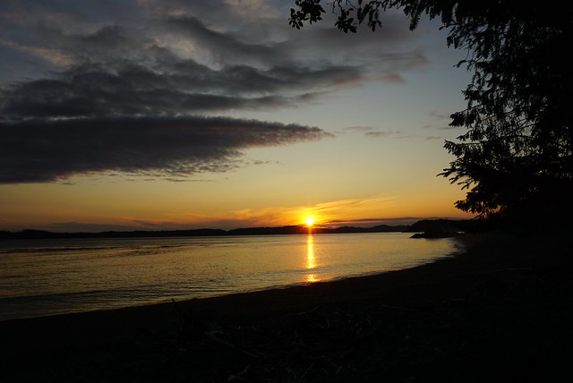
Day 6 was the most beautiful day on the trail. The one benefit of waking up at 5am is that I got to watch the sun rise over the ocean and up into the cloudless sky. It was beautiful walking along the rest of the beach, but it was going to make for hot hiking weather. As I said in my last post, I carried the group through Day 5, but I did not have the energy for it on Day 6. I’m a very type A personality and I wanted to make a quick hike to Skinner Creek to refill our water and hit the rest of the trail to the end. We left the campsite by 7am, which had been our goal, but we were moving pretty slow because no one was properly rested. I was kind of cranky cause I wanted to move faster and frankly I was really thirsty, so I pushed on ahead mostly on my own through the woods. I think I needed a bit of time on my own, so it was better I just continued on.
It’s 2km to Skinner Creek, about 1km of which is in the woods. It was muddy, but fortunately not too difficult and we did the 2km in an hour. The last section before you reach the beach though is crazy steep and you have to scale a rope about 20metres down this gully to reach the beach. It took a while for us to get down because we each had to wait for each other before the next person could use the rope, but when we finally reached the beach we were treated to one of the most beautiful views! I’m sure many of the other beaches were just as beautiful, but coupled with the beautiful blue sky and clear weather, Skinner Creek just seemed so much more beautiful. It’s a black sand beach that stretches for about 2 kilometres. I can see why everyone decided to camp at Skinner and Sutil and skipped Nahwitti (as beautiful as Nahwitti was, it couldn’t compete with Skinner). Like I said in my previous post, if I could do the trail again, I would add an extra day and camp at Skinner and Sutil instead.

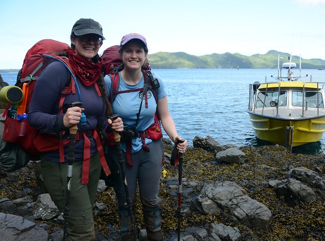
It was a relief when we finally reached the creek at around 8:30am. We were all so thirsty and we dumped out our water bladders and gave everything a good rinse in the river before refilling. Unfortunately we killed a lot of time because we had to filter 12 litres of water, but it was obviously necessary so we just enjoyed the view while we waited. There were several campers having a lazy morning at the campsite, though less than we expected. It seems like a ton of people had been dropped off on July 1 when the taxi started running, but that the traffic had immediately dropped off after that. Most people were continuing on to Sutil, but there was one group of guys that was doing the same thing as us. The only difference was that they were camping at Shushartie Bay and getting picked up the following morning. That had been our original plan, but there’s no water source or beach at Shushartie Bay, which means you have to lug a ton of water there, so we’d been lucky to get our pickup time changed to the afternoon. The guys informed us there was another group doing the same thing as us, but with a 2:30pm pickup, so they had already left.
It was 9:30am by the time we finally had enough water and took off again. It looked like the trail continued up behind the outhouse and crawled back up the bluff, so we headed up that way. After about 10 minutes it became pretty obvious we were going the wrong way and we think we’d gotten on the high tide track back towards Nahwitti River. There was a lot of confusion after that. The creek is filled with a ton of log debris, so we spent a lot of time poking around the area trying to find the trail head before Emily and Brandon finally discovered it up past the debris. They called out to me and Lien and we started climbing over the logs to catch up with them. There’s no obvious trail, so we were kind of bushwacking our way around the edge of the creek – I found Emily and Brandon and Lien was right behind me, but in the confusion he stepped on a bad branch and I watched almost in slow motion as he tried to recover his balance after the branch snapped under him and the momentum of his backpack pulled him over the edge. He rolled about 6ft over the edge of the bank and landed flat on his back in the creek. I jumped down immediately to help him – he was bleeding from several scratches, but fortunately he was otherwise uninjured, although I’m sure he had a few new bruises the following morning.

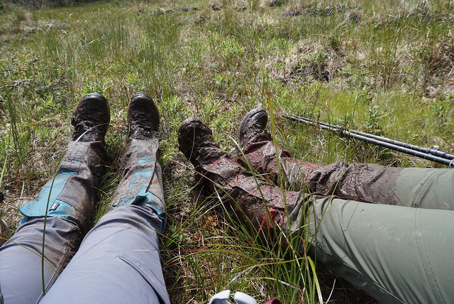
As with most accidents on the trail, it was a reminder that there’s not a lot of room for mistakes or complacency. We were getting anxious about struggling to find the trail and in his rush to catch up with us, Lien took a bad step. Fortunately he was okay and no lasting harm done, but it put him off kilter for a while after that. I bandaged up his knee and we continued on. The last 8.5km of the trail is probably the most notorious section on the North Coast Trail. It’s the first section of trail for most people and it’s entirely inland through what can only be described as a swamp. It’s known for its copious amounts of mud and I can see how it would be a pretty rough start to the trail. In fact, a lot of people straight up skip it and start at either Nahwitti River or Cape Sutil (I guess the boat can’t land at Skinner Creek?). On Brandon’s first traverse of the NCT, he skipped it and started at Nahwitti River instead. To be honest, after completing this section, I’m not really sure why they even bothered cutting the trail there. There’s absolutely nothing of value to see along the trail – I wanted to do it just so I could say I did the whole trail, but if I ever do the NCT again, I would skip it.
Fortunately, the biggest obstacle is mud. There’s obviously some other obstacles, but it’s primarily mud. 9km of mud gets pretty exhausting though and we gave up any attempt of trying to stay dry. It would be nice to just tramp right through it, but you do have to avoid it to some extent or you’d legitimately get stuck. Emily took a bad step at one point and sunk down beyond her knees. The only reason she was able to get unstuck is that she sunk into it near a tree that she was able to use to pull herself out. Lien took several tumbles, as did me and Brandon. Brandon was our cheerleader for the last day, which was a relief to me because I didn’t have the energy for it after Day 5. He kept us on task all day, giving us small breaks for snacks, but generally no more than 5 minutes.

The worst part about this section is that there is absolutely no breaking point. The only landmark on the entire trail is a single trail marker at the halfway point. The marker isn’t even legible anymore, but it was the main thing we were aiming for the first half of the trail. Its along a small boardwalk section, so we allowed ourselves a 10 minute break at the monument, though we never did stop for lunch. It took us 3 hours to reach the half way point (4.3km) and we had neither the time nor the energy to get our lunch out, so we went the whole day on just snacks. I really wish the park would invest in a tent pad or two with some benches at the halfway point. Not so people can camp there, but just so that there’s somewhere on the trail to pull over and have a proper break/lunch. There’s absolutely no where to stop across the full 9km, so we ended up hiking the whole thing continuously, taking a whopping 6.5 hours.
At the halfway point, the group of guys from Skinner Creek caught up with us on the trail. When they’d heard we were on a 4:30pm boat, they decided to hike to Shushartie to try and catch a ride on our boat since we seemed to be the only people on it. They were another group of witches and we gawked at how nimble and clean they were as they passed us. Meanwhile Emily was standing there with mud almost up to her crotch…

It was another rough day for Emily. She didn’t complain because she knew there was nothing else to be done about it, but she hit her limit about three quarters through the hike. Lien found his stride again during the last section of the trail and him and Brandon were leading us while me and Emily lagged behind. They were waiting for us at a stretch of boardwalk, just before we got there I heard Emily yell, but I continued on to the guys figuring she’d catch up in a minute, but when she did join us there were tears pouring down her face. She’d bumped her head on a tree and while she hadn’t really injured herself, it was kind of her breaking point and she just needed to let out the frustration.
We’d been tracking our pace all day and we were right on time to make it to the boat, so we decided that we were close enough to tell the guys to go on without us. I find it frustrating to have to wait for others when you’re already tired and we figured that if we were a little bit late, the guys could at least hold the boat til we got there (not that it would have left without us). So we set the guys free and actually our mood improved a lot after that. It took away the stress of having someone waiting for you and we ended up having a good sister chat along the way, which took our mind of the trail and our exhaustion.
Other than the group of guys that had passed us, we only saw 2 other people on the trail all day. It seems no one had taken a morning taxi in and they had come in on the 2:30pm pick up for the other group. We passed them about 45 minutes from the end and I felt really bad for them. I can’t imagine having a late start like that and then having to go through all that mud. Plus neither of them had gaiters and their packs looked really heavy.
Eventually we crested the hill and could see down towards the water of Shushartie Bay, which unfortunately still looked a bit far away. The last section of the trail was downhill and while the mud disappeared, it did get a little more technical. We suffered through it and were relieved when we finally saw the tent pads for the campsite sitting up in the trees. The last section of the trail is super steep and we had to take another rope rappel down to the bottom. I can’t imagine starting off the trail with all that steep uphill and then straight into mud for 9km – what a brutal beginning to a week long trail. As we were coming down the rope section we heard the water taxi coming into the Bay. We hollered down to Brandon that we were almost there. Our timing literally could not have been any better. Me and Emily exited the trail at exactly 4:30pm and literally walked straight onto the boat after 6.5 hours of continuous hiking. It turned out the boys were only about 10 minutes ahead of us at the end of the day.
The other group of guys shared the boat with us and were saved from having to camp at Shushartie. They’d had time to change out of their hiking boots and clean themselves up, but we walked on just as we were and plunked our bags down at the front of the boat. It was a little jarring boarding the boat. I’d honestly forgotten about Covid while we were on the trail (it was lovely), but we were quickly thrust back into it and asked to don face masks for the journey.
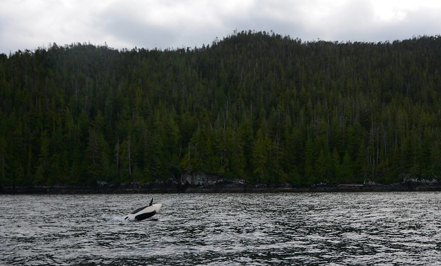
It’s about an hour back to Port Hardy and we had a pretty magical boat ride to end the trip. About half way back we stumbled upon a group of 20-25 orcas making their way through the pass. We could see them swimming all around us and several breached right in front of the boat (photo cred to Brandon)! They gave us an amazing show – it was nice to have some kind of reward after hiking through all that mud. It was hard to get up from the seats when we arrived at Port Hardy and we were super stiff when we exited the boat. Our original plan had been to camp at San Jo since we had to go back for our other car anyways, but we pretty much all knew that was not going to happen after the last two days. Until Day 5 we’d still been on board with the plan, but the last 2 days were just too much and we walked off the boat and straight into the first hotel we saw. We booked two rooms, peeled off our smelly clothes, showered, and then hit up the local pub for dinner.
So it was a bit of a rough end to the trip, but as I learned on the Juan de Fuca, there’s still something so rewarding about these long coastal hikes. It’s the longest hike I’ve ever done and it really does beat you down, but honestly, as brutal as the last two days were, the second I stepped off the water taxi, I still thought, “I would do that again”. I would do it totally differently, but I would definitely do it again. First I’ll need to do the West Coast Trail, but I still wouldn’t be deterred from returning to the NCT. Hiking really challenges you in ways you don’t expect, but the challenge is part of what adds to the accomplishment. Sure, it would have been idyllic to have had an easier hiking plan, or it would have been harder had it actually rained on us, but we did what we did. The trail beat us all down, but we still finished it. If you’re thinking of doing a multi-day coastal through-hike, maybe don’t start with the NCT, but get out there and challenge yourself on the Juan de Fuca, because it is a uniquely rewarding experience.
I’m going to finish of this series with a description of our trip plan and how I would plan the trip differently if I was to do this trip again. So the first column is what I did, but the second column is what I’d recommend for everyone else 🙂
| Day | What I did | What I’d Recommend |
| Day 1 | Ferry to the island, drive to Port Hardy, flat tire and camp on service road | Ferry to the island, drive to Port Hardy and stay in hotel overnight |
| Day 2 | Hiked 9.5km to Fisherman River | Water taxi to Nahwitti River, hike 2km to Skinner Creek and pretend like you hiked the 9km mud pit (or do the mud pit if you must) |
| Day 3 | Hiked 12km to Guise Bay and 5km day trip to Cape Scott | Hike 7km to Cape Sutil |
| Day 4 | Hiked 17km to Laura Creek | Hike 8km to Irony Creek |
| Day 5 | Hiked 13km to Irony Creek | Hike 13km to Laura Creek |
| Day 6 | Hiked 13km to Nahwitti River | Hike 17km to Guise Bay |
| Day 7 | Hiked 11km to Shushartie Bay, water taxi back to Port Hardy and stay in hotel | 5km day trip to Cape Scott, Hike 12km to Fisherman River |
| Day 8 | Drove back to Vancouver | Hike 12km to San Josef Bay |
| Day 9 | Drive back to Vancouver |

Pingback: Cape Scott and North Coast Trail: Part V | The Road Goes Ever On