Click here to start reading Part I.
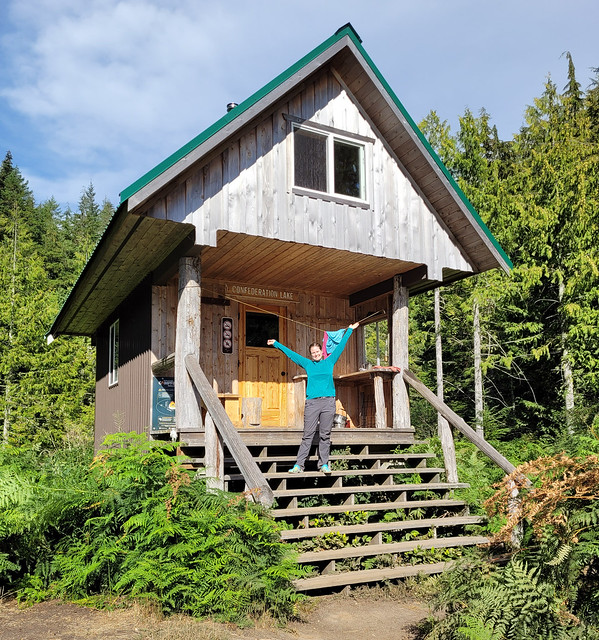
I was really lucky to have great weather while on the Sunshine Coast Trail. It was hot when me and Emily visited, but clear and sunny. Likewise, when I returned in September, it was cooler, but still nice and sunny. There was one day of rain in the forecast that coordinated with my day hiking from Confederation Lake to Tin Hat Hut. Tin Hat is the highlight of the SCT, so I was a little disappointed initially, but the forecast was looking good for the following day, so I figured that even if I didn’t get the view on the way up, I would still likely get to enjoy it.
It started raining overnight while I was at Confederation Lake, so I was glad to be in the hut. I got up early again to start hiking and was on the trail by 8am, despite the rain. Fortunately I was in the forest, so while it rained my whole hike down from the lake, I never got wet through any of my layers. The annoying thing about Confederation Lake is that after you leave the hut, you immediately undo the 600m of elevation gain from the previous day as the trail continues back down to Fiddlehead Hut on Powell Lake.
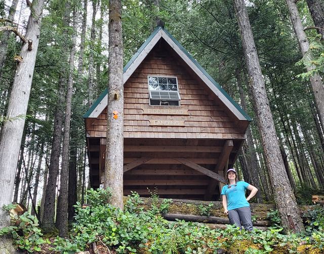
It got dryer as I hiked down and by the time I reached the bottom, it had stopped raining altogether! It’s about 500m off trail to hike down to the hut at Fiddlehead Landing, but of course I made the detour to see the hut. There was a small crowd at Fiddlehead (4 people). The friend from the previous night was there, along with a couple from Vancouver, and a mountain biker. The 3 hikers were also hiking up to Tin Hat for the night, so I had a quick conversation with them before they departed and then chatted with the mountain biker while having a snack and some lunch.
Fiddlehead Hut is really nice and I think it’s more popular than Confederation Lake because of its close proximity to Tin Hat, but I think the Confederation Lake Hut is better overall. The Fiddlehead Hut still has an enclosed sleeping loft, but it’s totally open on the bottom and because of it’s location in the trees, it’s cooler and darker.

After Fiddlehead, I had 8km to the top of Tin Hat Mountain, but it was almost 1200m in elevation gain, so I had my work cut out for me! As far as climbing goes, I would say Tin Hat is definitely the hardest climb on the whole trail. There are several other climbs, but the climb to Tin Hat feels the steepest and longest (technically Troubridge is longer, but it’s not as steep). I’m actually really thankful for the weather that day because even though the rain had stopped, it was still overcast. It was muggy climbing up the mountain, but not as hot as it would have been with the sun out. Blue sky did poke through a few times and I got one really nice view down into the valley, but the higher I went, the foggier it got.
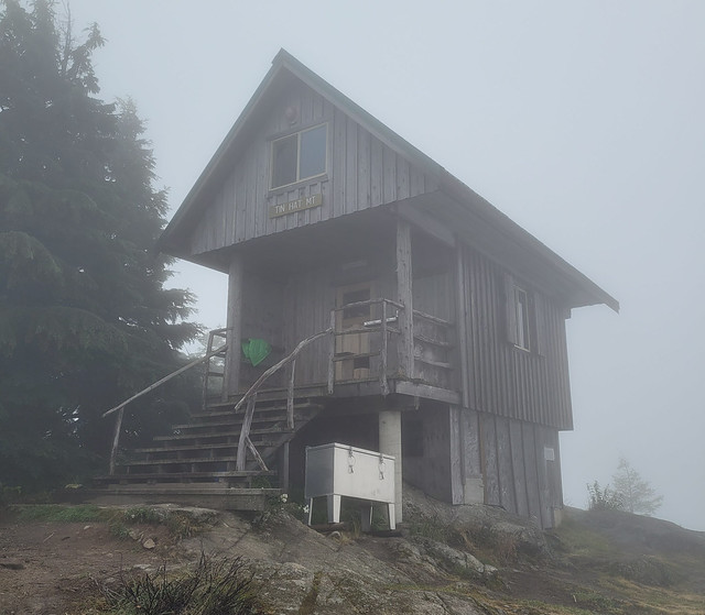
The challenging thing about Tin Hat Mountain is that there is no water source at the top. Most of the streams were still running in August, but when I returned in September, almost every creek listed in the guidebook was dry. When the campsite has water it isn’t a problem, but when your campsite doesn’t have water, it makes for large water carries. There’s a stream about 5km before the top, which is the last place to fill up, but even that stream was almost dry. As a precaution, I got most of my water from Powell Lake and then filled up my last bottle at the stream. I carried 5L of water up, which weighs a whopping 11lbs! 5L was definitely overkill, I think I would have been okay with 4L, but I don’t like having to conserve water and be thirsty, so I lugged it all up there for comfort. I wasn’t sure where my next water source would be the next day and I wanted enough water to get me down the mountain to Lewis Lake.
When I got to the top of the mountain, it was totally fogged in, but the hut is fully enclosed and it was so cozy in there I didn’t even care! Plus, it was the middle of the labour day weekend and I was thrilled to have other people around. The solo hiker was there, along with the couple from Vancouver, as well as a couple from Prague and their cute dog, so 6 of us in total. These 5 other hikers totally gave me life! I was still getting used to solo hiking at this point and it was so much fun to hang out with other people who have similar interests at the end of a long day. Everyone was really nice and talkative and I thought we had a lovely evening sharing about our lives. It really energized me. I didn’t know it at the time, but it was my last night camping with other people and it helped to motivate me over the next few days. Tin Hat Mountain is a really special place and I’m so glad I got to share it with such fine folks!

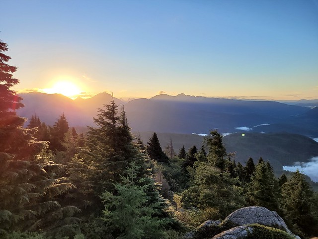
It was cold at the top with all the clouds, but they did start to clear out and around sunset we got a few glimpses of the view surrounding the hut. Even the limited view was incredible and I was excited for the following morning when it was forecasted to be clear. We decided to go to bed early and then we all got up to catch the sunrise at 6:30am (another benefit of September hiking – later sunrise).
It was totally clear when we woke and we enjoyed our breakfast out on the rocks while the sun came up. After breakfast I packed all my gear, but I opted to hike up to the top of Tin Hat Mountain before continuing on. The hut isn’t located right at the peak, but it’s only another 10-15 minutes to go up to the radio tower at the top. I’m so glad I did this because the view at the top is really out of this world! A definite highlight of the trip for me. The upper Sunshine Coast has so many lakes and mountains, it really makes for the most scenic view and I loved looking out over the backcountry with a 360 degree view. I had a little solo photoshoot at the top before saying goodbye to everyone and continuing on.

I didn’t see the solo hiker anymore after this as she only had 3 days left in which to finish the entire second half of the trail, and the other couples were heading back to Vancouver. Tin Hat is located at km89, so it’s pretty much exactly at the halfway point. I had 5 days to go before I planned to finish the trail and I hoped I would meet more hikers before then!
I had two options for that night. I could go a short distance (9km) and tent at Lewis Lake, which Carolyn told me was one of her favourites, or I could go a long distance (23km) and camp at the Elk Lake Hut. I would have loved to linger at Tin Hat, but I knew that by nightfall, I’d prefer to be at the hut, so I departed for Elk Lake, which was definitely the right decision distance-wise.
It was a bit of slog down to Lewis Lake with all the downhill, but the campsite was really lovely! I got there just in time for lunch and took a lake bath and washed some of my clothes before continuing on. I had 14km to go from there, which I wasn’t looking forward to, but it ended up being much easier hiking than anticipated. It was quite flat and I ended up powering through 7km in 90 minutes! That was probably a pace record for me, but it came at a cost and I noticed I had 2 small blisters when I stopped for a snack, so I forced myself to slow down to protect my feet.

I saw a couple exploring Lewis Lake and 1 solo male hiker going in the opposite direction, otherwise, I didn’t see anyone else all day. The topography was interesting between Tin Hat and Mount Troubridge because you’re pretty much hiking through or along clear cuts the entire way. You can’t see what’s been logged when you drive the sunshine coast along the main highway, but there’s a lot of it going on in the backcountry. I think that’s one reason I didn’t encounter much wildlife, because of the heavy machinery. Though I did have to go through a few detours where the logging had forced the trail elsewhere.

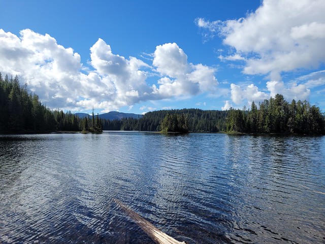
It’s a pretty gentle uphill for most of the day, the only real challenging part is the last 1-2km, where there’s a steep climb up to the lake. I pushed through, arriving around 4pm, but was immediately disappointed to be the only one at the hut. I expected it, but it was still disappointing. Elk Lake is a small lake with a big log wharf extending out into it. It’s a partially enclosed hut with an open front along the trail and windows looking down on the lake. Unfortunately there was no service at the hut, so it was probably my most anxious night on the trail, also not unexpected seeing how it would be my first night alone.

I played some music while I cooked dinner and did my nighttime chores. The worst part about camping solo is the monotony before bedtime. I hadn’t brought a book with me, so there was really nothing to do. I had an audiobook, but I was trying to conserve battery, so every minute listening to my audiobook or music was a treat. I killed time until sunset and then opted to go to bed early. I was nervous about bears, but felt reasonably safe in the sleeping loft and was honestly more nervous about mice. I’d heard they could be pretty bad in the huts, but shoutout to everyone keeping the huts clean this season because I didn’t see a single mouse in any of the huts I stayed in! So fortunately, I ended up sleeping better than anticipated my first night alone on the trail and it did get easier after that. Continue reading Part VI.