Cape Scott and North Coast Trail: Part III

The Saga continues – here’s Part 1 and Part 2 if you’re joining in the middle.

On Day 3 we finally started the North Coast Trail. As I mentioned before, most people start with the North Coast Trail and continue on to Cape Scott, but because of some conflicts with the water taxi dates due to Covid-19, we decided to do the trail backwards. So instead of starting with a water taxi from Port Hardy to Shushartie Bay, we had already hiked 37km and we still 43km to go. We hiked from Guise Bay to Nissen Bight before lunch and then continued from Nissen to Laura Creek, our first section on the North Coast Trail.

From the end of Nissen Bight, it’s about 5km in the woods, followed by another kilometre along the beach to reach the campsite. Our feet were already aching from pounding across so many beaches, so it actually felt like a bit of a relief to start climbing up into the woods. There was a noticeable change to the conditions of the trail as soon as we entered the forest. It started with a steep climb up towards Nahwitti Cone and then it was 5km of poorly maintained trail and mud.

DSC06187

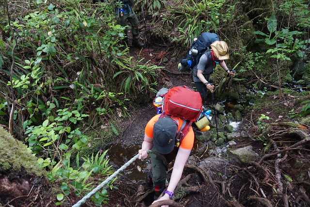
The North Coast Trail is a pretty bare bones trail, besides keeping the brush at bay, it seems that the trail is left pretty wild and it makes for a very technical hike. There’s a lot of mud to navigate around as well as tons of obstacles from the trees. You’re constantly climbing up and over logs, under branches, and jumping your way around mud pits. The Juan de Fuca was a similar experience for me and Emily, so we didn’t come across anything unexpected, but we definitely forgot just how challenging and slow these kind of hikes can be.

At first the obstacles were a welcome distraction from our aching feet. When you put your brain to work navigating the obstacles, it does distract from your other pains, but the forest paths make for REALLY slow progress and eventually you just get frustrated at how long it takes to make any kind of progress. This was Lien’s first real challenge. He’d never been on a technical coastal trail before and so he really had no frame of reference for what it would be like. When we first switched our plans from Mount Assiniboine to the North Coast Trail, his first response was, “well at least it will be an easier trail!” We all laughed at him and informed him it would actually be a lot harder, but I can see where the misconception comes in and I have made the same assumption in the past. Mountain trails appear to be harder because of the large elevation gain, but coastal trails often still have a ton of elevation gain hidden among the relentless up and down along the coastline, as well as they’re usually a lot more technical.

HOP_3962

There was a marked difference on Day 3 though in that we barely saw any people. We’d started hiking Cape Scott on the weekend, so it had been crawling with people, but it was now Tuesday and so even on our hike to Nissen Bight we didn’t see many people. After Nissen the trail really emptied out. We saw one hiker just as we were starting the climb to Laura Creek – he was returning from an overnight at Irony Creek (that’s a 19km hike!). After that the only other people we saw was one group of guys who were camping at Nissen and had day hiked out to Laura Creek and back. In mine and Emily’s opinion, it’s a waste of time trying to avoid the mud on a trail like the NCT, so we were both pretty muddy and had wet feet by the end of the day. We had wet feet the entire 4 days we hiked the Juan de Fuca, so in our opinion keeping our feet dry until Day 3 had been a pretty big success. But when we passed the guys coming back from Laura Creek and saw their completely mudless legs and boots, we had to conclude that they were clearly witches to stay so dry.

Lien struggled along this section, mostly from the repetitive uphill sections. I started stronger along the wooded stretch, but eventually it really got to me too. I was tracking the hike along my GPS and every 30-60 minutes I’d check in to see how much progress we were making and it was always a mistake. Your location barely moves and it really only serves to de-motivate you. What was more depressing was that I’d read in the trail book that this was one of the easier wooded sections of the trail, so it made me really apprehensive about what was to come later. So much of making it through these long hikes is mental and often you just have to focus on making it through one part at a time.

DSC06214

Unlike the rest of us though, Day 3 was where Emily peaked. She had a rough Day 2, but she was in her element on this section. Despite her blistered feet, she was our cheerleader for the day and led us through the worst of it. One of the real saving graces of having 4 people in your group is that we didn’t all fall apart at the same time. There was always someone who was struggling, but when that happened, someone else would always step up to help motivate the group. The constant uphill was Lien’s mental block for the day, so we all cheered when we finally started heading downhill in earnest and could see the beach peaking out through the trees. We still had 1 more kilometre to go across the beach, which is it’s own kind of hell at the end of a long day, but at least you make a faster pace.

There was some confusion about where the water source was, so we spent a bit of time poking around for it at the end of the beach, before a closer read revealed that it was actually located right at the campsite. I’d read Laura Creek only had 4 tent pads, so despite seeing no one else on the trail, I was still a little concerned about availability. Me and Emily were anxious to get off our weary feet, so we took off towards the campsite. Fortunately there was only 1 other group of 5 guys at the campsite and they were only using 2 of the tent pads, so there were 2 more left for us.

DSC06213

I have to admit, as relieved as I was to sit down, the tent pads were a little gloomy after the beautiful campsite the previous night. The trees were extremely thick and didn’t let a lot of light in, plus everything felt damp. Fortunately Brandon is much more determined than me or Emily and when he showed up, he dropped off his backpack and declared there was no way we were camping in the woods and he would find us a spot on the beach.

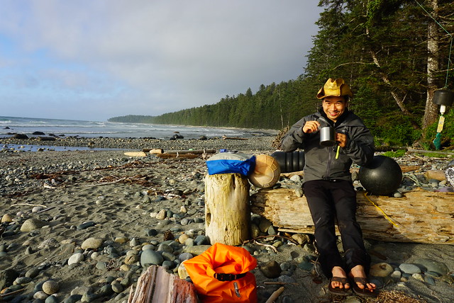
There’s no where to camp on the beach near the tent pads because it’s a steep cobble beach, but if you continue another 200m to the water source, Laura Creek, there’s a small sandy beach with enough room for 3 tents. There was one couple set up there already and they kindly moved their tent to the side so that we could set up our two tents next to them. It was extremely windy, but a definite improvement over the wooded tent pads! So much thanks to Brandon for that!

We put up the tents as fast as we could and chucked all our gear inside to keep them from blowing away. We changed right away because it was cool with the wind in our sweaty clothes. Once I bundled up with a few layers though, I forgot about the wind and was thrilled when the sun finally came out for the first time since we’d started the trail!

DSC06225

The weather on these trails really is wild – it’d been overcast most of the day, but within a half hour the wind completely blew the clouds away and we found ourselves with a gorgeous sunny beach view – so that helped with the chill as well. It was somewhere around 7pm at this point. It ended up taking us about 4 hours to go the 6km from Nissen to Laura, so we knew we were in for some longer days.

By Day 3 we’d started to get into a bit of a routine. Lien got water from the creek to start filtering, Brandon started working on getting a fire going, and me and Emily started boiling water for hot drinks/soup and started making dinner. Emily was the chef for day 3 and served us a cheesy pasta that we’d made from a backpacking website. It was vegan so it used coconut milk powder and nutritional yeast to get the creamy cheesy flavour – it was my first time using either ingredient and it was actually pretty good.

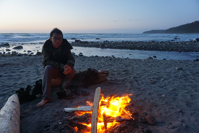
The only downside to our beach campsite was that it was a 200m walk back to the outhouse and bear cache, but definitely still worth it and we ended up having a great night relaxing on the beach by our fire. Laura Creek definitely had the best sunset of the trip; when the clouds cleared out we had an excellent view of the sun as it dipped below the horizon and filled the sky with its orange-yellow glow. We were zonked from the long hike, but relieved that our biggest day was now behind us. Over the next 3 days we’d be averaging about 12km a day, so we were optimistic that though the hiking wouldn’t get easier, the days would at least get shorter. It was an incorrect assumption, but more on that in the next entry, Part IV!

DSC06239

Advertisement

Cape Scott and North Coast Trail: Part II

Continuing on from Part I, after an eventful journey to the trailhead and our first night on the trail, we still had 5 more days of fun ahead of us!

We never made it to Nel’s Bight on Day 1 and still had 8km to go to the beach, so we decided to aim for it as our lunch spot on Day 2. We weren’t in too much of a rush in the morning, but we made good time taking down camp (ended up being our fastest day packing up), and had a speedy start, hiking the 4km to the trail junction in just over an hour. At the junction one trail branches off to Nel’s Bight and Cape Scott, while the other continues on the Nissen Bight and the rest of the North Coast Trail. We’d be heading there eventually, but first we wanted to see Cape Scott.

DSC06013

It’s another 4km from the junction to Nel’s Bight and we continued on with ease. The trail was reasonably muddy on Day 1, but it was surprisingly clear on Day 2. I would say this is the easiest section of trail in the park (except perhaps for the trail to San Jo). The trail continues through the woods with the first landmark being detritus from one of the old Cape Scott settlements. Cape Scott was originally settled by the dutch in the late 1800’s, but it was too remote and the government wouldn’t subsidize any services because they didn’t want to encourage the colony, so it was abandoned. It was settled again in the early 1900’s and peaked at a community of around 200 individuals. There’s not much left now, but you can see some old debris from the community that settled at Hanson’s Lagoon.

On the way to Hanson’s Lagoon, you pass across a large open marsh area. There is a small road that continues on to the lagoon, but our path took us around the lagoon to Nel’s. It’s very green and lush, but the clouds decided to drop a quick bout of rain on us as were passing through and we ended up running most of the way across to the safety of the trees. Though of course once we reached the trees it had pretty much rained itself out, so Brandon joked we must smell bad and nature was just treating us to a quick shower.

IMG_0357

We made it to Nel’s Bight before noon, which Brandon affectionately refers to as Tent City. Along the way we ran into one of the Rangers that lives on Nel’s and he told us the previous evening (saturday night), he’d estimated there were 100 people camping on the beach, so the name was definitely accurate. Fortunately Nel’s is a giant white sand beach with lots of space for tents, so there’s no concern about finding a campsite. It’s the most popular beach in the park because you can hike there in a single day and it’s a popular stopping point for people visiting the lighthouse. Most people camp at Nel’s and day hike to Cape Scott. Since we’d stopped at Fisherman’s River, we had a different destination in mind. Guise Bay is located 4km past Nel’s Bight and it was Brandon’s favourite beach in the park, so we decided to lug our packs the extra 4km.

It was an excellent choice! We stopped at Nel’s for lunch and it was extremely windy, sending huge crashing waves along the beach. It was a little drizzly, so we sent up a tarp but didn’t stay too long. The drizzle didn’t last long though, so it was a nice 4km stroll to Guise. You head back into the woods briefly at the end of Nel’s and then come out at Experiment Bight – another long sandy beach. It’s also perfect for camping, but there’s no water source or facilities so I don’t think it gets used very much. After Experiment Bight you go back into the woods, this time crossing the peninsula to Guise Bay. Because Guise Bay is on the opposite side, it doesn’t get as much wind and the water was a lot calmer. I immediately liked it and with only 1 other tent on the beach, we got a great campsite without the crowds.

HOP_3872

It was overcast most of the day, which I think is super common at Cape Scott, but the rain stayed away for the rest of the day and it did slowly get clearer as the day progressed. We set up our campsite and decided to continue on to finish the rest of the trail to the lighthouse as a day hike. We left our backpacks behind and stuffed our pockets full of snacks. From Guise Bay it’s ~5km round trip to the lighthouse, which is located just outside the park boundary and is a government facility.

I didn’t love the walk to the lighthouse. My feet were starting to hurt after so much walking. I didn’t have any blisters or hot spots, but it was just a general throbbing on the soles of my feet from being on them for too long. Emily was also having a rough time. She has awkwardly shaped pinky toes and she always gets blisters, so she was battling both sore feet and a blister. It was cool to see the lighthouse though. There’s not a whole lot there – it’s just a wire frame tower and what looked to be 3 houses and an office building. I’m not sure if all the houses are occupied, but we talked to one of the inhabitants and he said he’d been living there for the last 20 years! Apparently he gets a supply drop once a month and that’s what he lives on. It was neat but I can’t imagine living so remotely, especially in such a foggy place (sounds like home lol).

DSC06069

We topped up our water bottles from the tap at the back of one of the buildings (filtered water yay!) and then headed back to Guise. Emily was a bit out of it when we got back – her feet were hurting her a lot and in retrospect, I suspect she may have been a bit dehydrated – so she took a nap. I helped Lien start re-hydrating dinner and Brandon went in search of the water source on the far side of the beach. Lien followed him about 10 minutes later and I was treated to a little show from the other side of the beach. Our timing with collecting water was really good because we didn’t realize the water source was only accessible when the tide was low. I watched as Lien zigzagged his way across the pinch point and disappeared into the woods. He came back out with our water bladders about 10 minutes later and as soon as he reached the pinch point again, he suddenly turned around and took off running back towards where Brandon was still collecting more water. He popped in and out of the woods and ran back across the beach and over the pinch point and was followed moments later by Brandon in a desperate attempt to not get his feet wet! Fortunately we all kept dry and we had collected enough water to see us through the evening and the next day.

DSC06050

It had been a bit of a mauzy day, both weatherwise and in spirit. Including the lighthouse, we’d trekked 17km, so we were feeling pretty tired. Brandon, our eternal optimist, decided to get a campfire going and I can definitely say the evening improved a lot from there! We got supper started and coaxed Emily out of the tent. The wind dropped down, the clouds lifted, and the fire warmed us all up! It ended up being one of my favourite nights on the trail. We had chili for dinner and then spent the rest of the evening lounging around the campfire listening to music on Brandon’s speaker. The sun never really peaked out, but the clouds did break-up and treat us to a lovely pink glow over the beach as the sun was going down. It was the last week of June and we were further north, so the days were extremely long. We found ourselves staying up so late every night because it would be after 11 by the time it would finally get dark.

DSC06085

On Day 3 we awoke to a bit more of the same. Again, it wasn’t raining and it was brighter than the previous day, but still pretty cloudy. It was on the cooler side, but it was good weather for hiking. We packed up camp and started back the way we’d come, repeating our 4km hike back to Nel’s Bight and then another 4km to the junction. Just before we left the beach we heard some guys coming down the trail yelling into the woods. We figured they were just making their bear calls because they were the first ones on the trail (we regularly yell into the woods to keep the wildlife away). We were right, but it was because they’d actually seen a bear. They were on their way to the lighthouse and came on to the beach fully armed. One guy had his bear spray held a loft and they were both sporting knives. Apparently a bear had followed them for most of the trail from Experiment Bight to Guise Bay and while he didn’t seem aggressive, they weren’t taking any chances. The bear finally spooked off when they got to the beach, but since we were going back the way they’d just come, we had a nice sing-a-long on the way back – no sign of the bear.

Along the way we ran into some more rangers who were doing maintenance along the trail. They asked us about our plans and we told them we were going all the way to Shushartie Bay. They informed us they were the North Coast Trail maintenance crew and while they had conducted their initial assessment for the year, they hadn’t done any maintenance to date because of COVID. They warned us a lot of the brush needed to be cut back and that some of the trailheads might be difficult to find if the buoys were knocked down, but that the trail was still doable. So with that ominous warning we set off towards it.

DSC06108

After re-tracing our steps 8km to the junction, we had to go 2 more kilometres to Nissen Bight. It was a long day on the trail because we wanted to go all the way to Laura Creek, a total of 17km with our packs. I always like to do more hiking before lunch than after, so we pushed 10km to Nissen Bight before stopping for lunch. My feet were definitely throbbing by the time we reached the beach and I wasn’t looking forward to another 7km after lunch. But we pushed the thought from our minds and tried to enjoy our lunch. Nissen is another big beach, pretty similar to Nel’s in that there’s lots of camping space and big waves crashing along the beach. I had exhausted my egg salad wraps, so I was on to cheese and salami wraps with dehydrated hummus. The hummus worked out really well, so it made for a filling lunch, though it got a bit repetitive as I ate it for the next 3 days.

Nissen Bight marks the transition from the Cape Scott Trail to the North Coast Trail. Cape Scott has been a well developed trail for ages and sees tons of visitors, while the North Coast Trail is a new trail that was only created in 2008. From Nissen Bight it’s 43km to Shushartie Bay and the water taxi that would bring us back to Port Hardy. We had 3.5 more days of hiking and 3 nights to complete it. I wasn’t too thrilled to be back on my feet, but I was excited to start exploring this less busy and more rugged part of the trail. We trekked another kilometre across the beach as the sun finally started to peak out from behind the clouds and then started our North Coast Trail adventure! To continue, read Part III.

DSC06164