I’ve featured a lot of hikes on this blog and while I try to write about all kinds of hikes, I have a tendency to focus on my big, backcountry trips. But I believe hiking is for everyone and I’ve done lots of great, short, easy hikes that I want to feature in this post. Just keep in mind that no matter where you’re hiking or how short the hike is – always be prepared. Check out my post on personal safety to learn more about trip planning and the 10 essentials.
Without further ado, here are all my favourite short hikes by region:
Sea to Sky
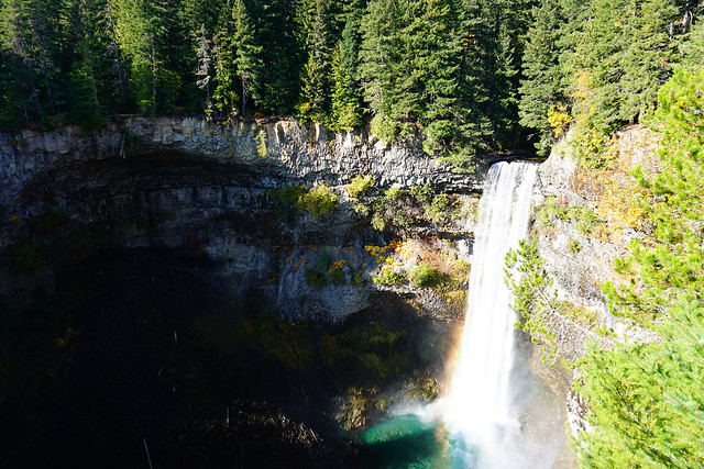
Brandywine Falls (1km, 0m gain) – Located right on the Sea to Sky highway before you get to Whistler. Walk out to this amazing waterfall viewpoint! You can extend the hike down to the bottom of the falls, but wayfinding skills are required as it’s not well marked.
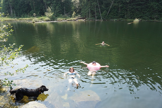
Brohm Lake (4km, 100m gain) – Located just past Squamish on the Sea to Sky highway. Do the circuit around the lake, or extend the hike up to Tantalus Lookout or Brohm Interpretive Forest. A great place for swimming in the summer.
Alice Lake (1.5km, 0m gain) – Located in Alice Lake Provincial Park, just past Squamish. Hang out at the day use area and go for a stroll around the lake. Great for swimming in the summer.
North Shore
Lighthouse Park (6km, 0m gain) – Located down by the water in West Van, make your own adventure in this park! Hike to the lighthouse and hang out on the rocks or explore the many forested nature trails.
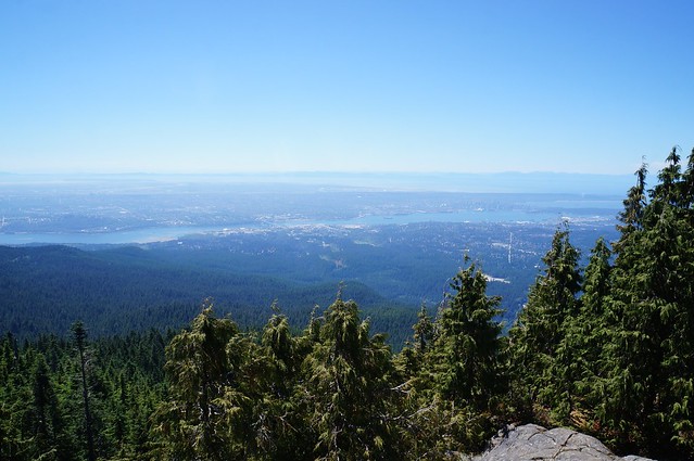
Bowen Island Lookout (4km, 110m gain) – Located in Cypress Provincial Park, you can do this trail all year, just use snowshoes in the winter. The trail is a little steep, but has amazing views of Howe Sound and Bowen Island.
Dog Mountain (5km, 0m gain) – Located in Seymour Provincial Park, this is another hike that can be done in summer or winter. The trail has great views of the city – add a kilometre and hike to Dinkey Peak on the way down for mountain views.
Tri-City Area
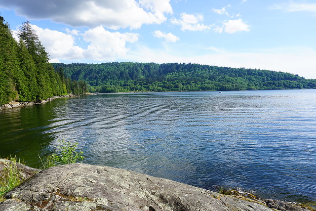
Belcarra Regional Park (5km, 0m gain) – There are two hike options in Belcarra: Jug Island and Burns Point, which leave in opposite directions from the parking lot. Both are 5km, but Burns Point is the easier hike. Jug Island hikes up and down while Burns Point follows the coast.
Crystal Falls (7km, 0m gain) – Located in Coquitlam, this is one of the longer hikes on the list, but it’s totally flat and has rewarding views of the falls at the end! Wear appropriate shoes – this one can be muddy!
Minnekhada Park (4km, 100m gain) – Located near Pitt River in Coquitlam, there are two lake loops that are ~4km each, or if you’d like more of a challenge, hike 7km up to High Knoll for a view of the valley. Great for birdwatching.
Heading East
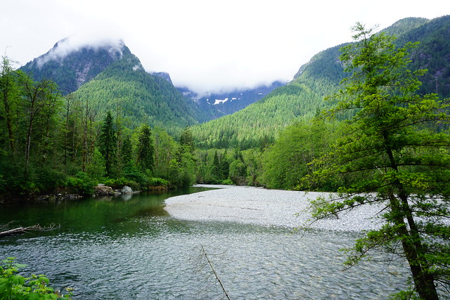
Gold Creek East: Lower Falls (5.5km, 0m gain) – Located in Golden Ears Park, it’s a beautiful, flat hike along the river to Lower Falls. Extend the hike by continuing on to Viewpoint Beach.
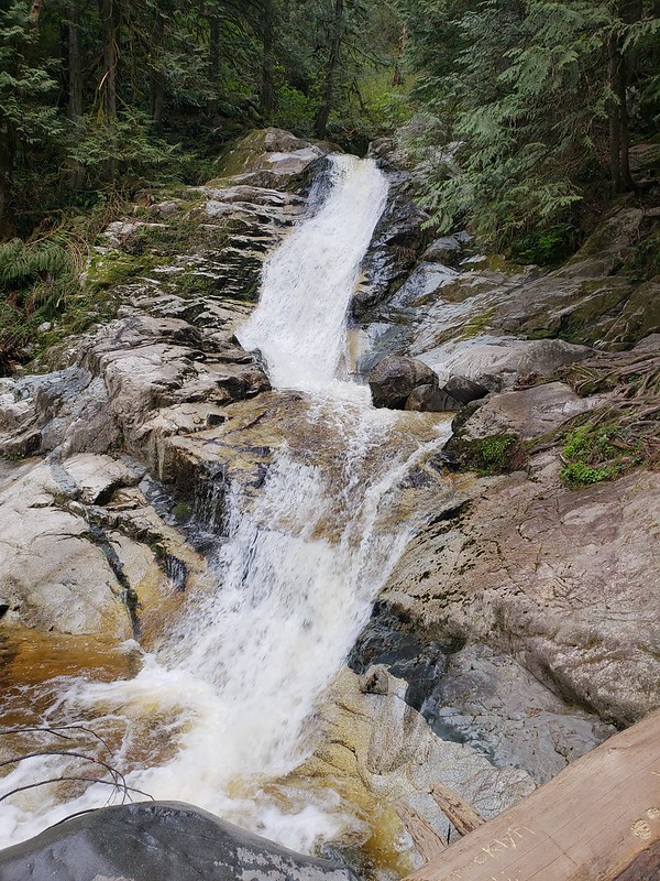
Bridal Veil Falls (1km, 50m gain) – Located just off Highway 1 past Chilliwack, a short hike to a huge waterfall cascading down over the rocks!
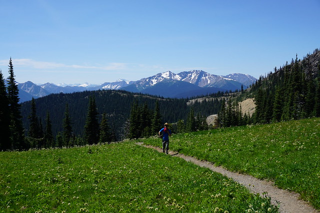
Paintbrush Trail (3km, 0m gain) – Located in Manning Park, it’s a bit of a drive, but Paintbrush Trail has the most amazing views of the surrounding mountains and at the right time of year, is bursting with beautiful alpine wildflowers.
Coastal and Islands
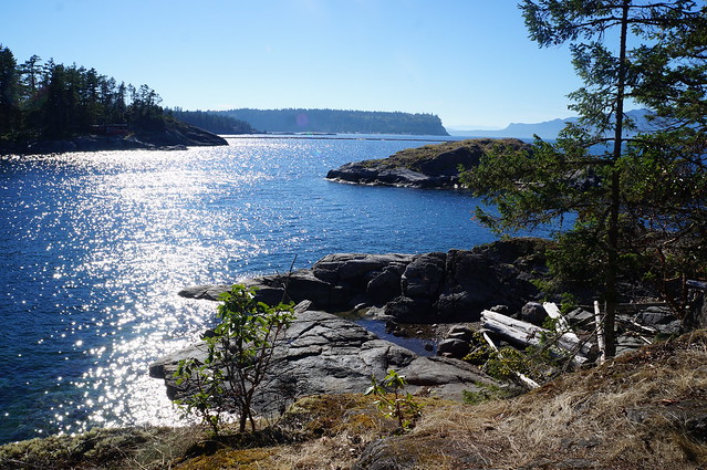
Bowen Island Sea Walk Trail (2km, 0m gain) – Located at the Southwest end of Bowen Island, this short there-and-back hike to Cape Roger Curtis Lighthouse has beautiful ocean views.
Smugglers Cove (3km, 0m gain) – Located on the Sunshine Coast, Smuggler’s Cove is a beautiful coastal trail that winds through wetland and rocky coast outside Halfmoon Bay.
Mount Norman (2.5km, 200m gain) – Located on South Pender Island, Mount Norman is the steepest hike on the list, but has beautiful views of the Gulf Islands. Extend the hike to Beaumont Campsite (6km) to make this a truly coastal hike.
Vancouver Island
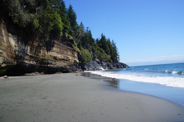
Mystic Beach (4km, 65m gain) – Located past Sooke on the far south of the Island, this is a great way to sample one of the highlights of the Juan de Fuca Marine Trail. Hike through the woods to a beautiful sandy beach.
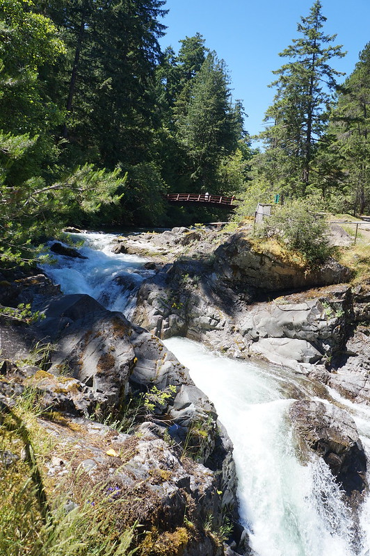
Little Qualicum Falls (3km, 65m gain) – Located just off the Alberni Highway in Little Qualicum Falls Park, this short loop takes you along the river to several beautiful waterfalls!
Tonquin Beach Trail (3km, 65m gain) – Located in Tofino, Tonquin Beach is a great place to watch the sun set, hang out on the golden sands, fish, or have a campfire. Just bring your headlamp for the hike back.
Growing up in Newfoundland, I never really liked Spring because it’s barely a season there (pretty sure we just get a second winter). But Spring in the Lower Mainland is fantastic! It actually warms up when it’s supposed to and pretty much the entire city has been in bloom this April. But as much as I love it, it also kills me a little bit because even though it warms up so much in the city, it still takes a long time for all the snow in the mountains to melt. Proper hiking season doesn’t really start until late June, early July, but there are lots of lower elevation hikes that you can do in the Spring that are located right in our backyard! Here’s a few of my favourite Spring hikes to tide you over to those warmer summer days:
Baden Powell Trail
The Baden Powell Trail is a whopping 42km long trail that runs all the way from Deep Cove to Horseshoe Bay. But don’t be intimidated by the length, the entire trail can be done in a series of day hikes, they’re just best done with two cars (one at the start and one at the end) so that you don’t have to backtrack. The four main trail sections include Deep Cove to Lynn Canyon, Lynn Canyon to Grouse Mountain base or Cleveland Dam, Cleveland Dam to Cypress parking lot, and Cypress to Horseshoe Bay. I’ll admit that I’ve only actually done the Deep Cove to Lynn Canyon section, but I’m hoping to hike a few more sections! I believe the more popular sections are between Deep Cove and Grouse, because there is significant elevation gain between the Cypress Mountain sections. Either way, there’s a lot to explore on this forested trail! Fun fact, the trail is named after Lord and Lady Baden-Powell, the founders of Girl Guides and Boy Scouts!
Big Cedar and Kennedy Falls Trail
This is a great trail located in North Vancouver that hikes through the forest to 2 main attractions, a really big cedar tree and Kennedy Falls. The hike is 10km long, with approximately 150 metres in elevation gain. We thought it would be a pretty quick hike with such limited elevation gain, but there is a lot of up and down through the woods, so the cumulative elevation gain is greater. It’s also a more technical trail than I was expecting, so if you’re looking for an easy walk in the woods, this isn’t the one for you. However, if you’re looking to warm up those legs in preparation for the summer hiking season, this is the perfect hike! There is a lot of spray coming off Kennedy Falls with the Spring run-off, so bring a rain jacket if you want to get close for photos. The trail is dog friendly, but small dogs might struggle with all the trees and roots across the trail.
Jug Island Trail
If you don’t want to travel to the North Shore, there’s some great hikes available in Belcarra Regional Park, located just past Anmore. Jug Island Trail is one of my personal favourites because it’s a short hike, but a good warm up. It’s only 5.5km long and has about 100 metres in elevation gain (it’s listed as having none, but that’s because it starts and ends at sea level). It’s a mostly forested hike, but there is a nice view about midway through the trail looking down at the backside of the peninsula, as well as a beautiful view of Jug Island and Indian Arm at the end of the trail. The beach at the end of the trail is also accessible by kayak from Deep Cove or Cates Park if you’re up for a boating adventure! This is the only trail I’ve done, but there are other short trails in the area such as Admiralty Point and Sasamat Lake.
Lower Seymour Conservation Reserve
The Lower Seymour Conservation Reserve is located between Grouse and Seymour and protects the ecosystem running up towards Seymour Lake, one of Metro Vancouver’s 3 water supply lakes. I worked in this area for about 8 months, so I had lots of time to explore some of the trails and there’s a ton of options to choose from! They’re all pretty similar in that they’re mostly forested trails (common theme for Spring hikes as it’s too early to get up in the mountains). Parking is available just off the end of Lillooet Road at the Rice Lake Gate, at the Lynn Canyon Ecology Centre, or off of Rice Lake Road at the entrance to Lynn Headwaters Regional Park. I’d personally recommend avoiding the Ecology Centre as it draws a lot of tourists for the suspension bridge, it’s only about 1km hike to the bridge from the other entrances if you still want to visit. Some of my preferred trails include Fisherman’s Trail (13km), which hikes up to a viewpoint overlooking the River, and Rice Lake (3km), which is great for fishing (if you’re into that). I also like the Lynn Headwaters Trail (6km), which follows Lynn Creek and can be extended to hike to Norvan Falls (14km). The falls are definitely best explored in the Spring when run-off is high, by Fall, the falls are just a trickle!
Lighthouse Park
I know, I know, all the locals are already super familiar with Lighthouse Park, but as an East Coaster I only visited the park for the first time last year! This is the place to go if you’re after ocean views! There’s still a ton of forested trails here, but they pop in and out of the woods along the coastline. I think of Lighthouse Park as a bit of a build-your-own-adventure trail because there’s tons of trails running through the park and you can pick which circuit you want to do. When I visited, we mostly followed the coastline, making a bit of a loop from the parking lot. There’s limited elevation gain in this park, but lots of great views!
Golden Ears Park
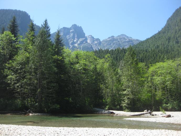
I’m a huge fan of Golden Ears Park. It gets crazy busy in the summer though, which is why Spring is great time to visit! Don’t even think about doing Golden Ears Peak, it’s way too early for that, but there are some nice trails located at the back of the park. Drive to the far end of Alouette Lake and park in the North Beach Campground lot (do not actually go into the campground, parking is not permitted there). There’s two trails, the Lower Falls Trail and the East Canyon Trail to Viewpoint Beach. At 5.5km, the Falls Trails is really more of a walk, but affords some nice views of the mountains from the river and a nice waterfall at the end of the trail. The trail to Viewpoint Beach is a little longer at 8km, and has a great view looking up at the mountains from the beach at the end. There’s about 200m elevation gain on the viewpoint beach trail and none on the falls trail. On maps, it looks like you can connect between these two trails, but I’ve done these hikes several times and I’ve never been able to find where the two connect.
Capilano Regional Park
This is another park I’ve explored as part of my work and it is a great urban trail in North Vancouver. If you’re feeling ambitious, you can hike all the way from Ambleside Park up to Cleveland Dam (~14km), but you can also access the trail from Cleveland Dam or from some of the local roads on the West side of the Park. The engineer in me loves Cleveland Dam and there’s a great view of the Lions looking out over Capilano Lake (another one of Metro Vancouver’s drinking water supply lakes). You can drive right up to the lake, but I’d recommend starting somewhere lower on the trail and making the dam and lake your lunch break in the middle of the hike. I like this trail because there’s tons of neat bridges to cross over with great views of the Capilano River and canyon. You can also stop in and visit the fish hatchery along the way!
Burnaby Mountain and Barnett Trail
There’s tons of great Spring trails located around Burnaby Mountain and it’s easy to take transit to them! I’ve personally done the Burnaby Mountain Summit Trail, which loops around the top of the mountain, and the Barnett Trail, which loops around the back of the mountain. The best views are probably from Burnaby Mountain Park. Both of the trails overlap each other and I would definitely consider them urban trails as they loop in around the SFU campus and the bike park, but there are a few views looking down over Indian Arm and you do get a nice workout climbing back up the mountain. Both hikes are under 10km.