Hiking Skywalk North

Last week I said Tricouni Meadows might be my favourite hike of the season… then I did Skywalk North and now I can’t decide! After such a successful hike at Tricouni, I was enthusiastic to try another day hike. This time we decided on the Skywalk North Trail in Whistler – it doesn’t require any off-roading, but is a much longer trail with much more elevation gain.

HOP_7641

I’ve heard of the Iceberg Lake hike, which is quite popular, but I hadn’t heard much about the Skywalk trails, which I found in the 105 Hikes book by Stephen Hui. There’s a ton of hiking trails in the area and many mountain bike paths – the Skywalk trails consist of 2 loops with a shared middle section. The South Trail leaves from Alpine Way and the North Trail leaves from Mountain View Drive (both in Whistler). The South Trail is a bit shorter, but if you want to visit Iceberg Lake, they’re both probably about the same length because it’s a branch to visit the lake on the South Trail, whereas the North Trail goes right past it.

20220827_122312

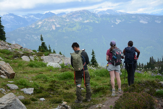
So both trails are ~20km including the lake, though we tracked 22km on GPS, and over 1000m in elevation gain, so it is definitely a big hike and you should give yourself enough time to complete it. We started just before 10am and didn’t finish until just after 7pm. For the most part it’s not a very technical hike and it has a lot of flat sections, but this just means it does a lot of gain in a short distance, so it is steep.

IMG_1256

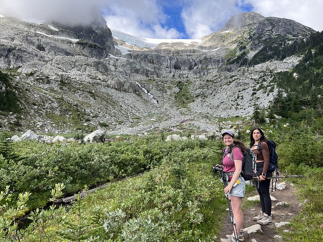
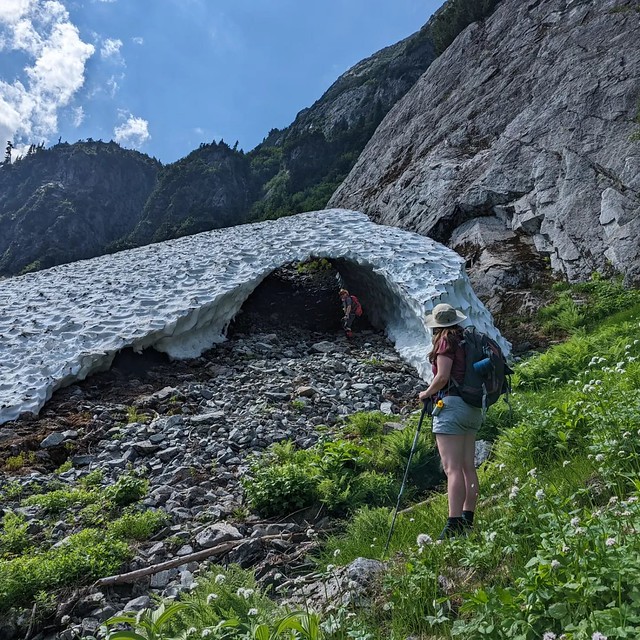
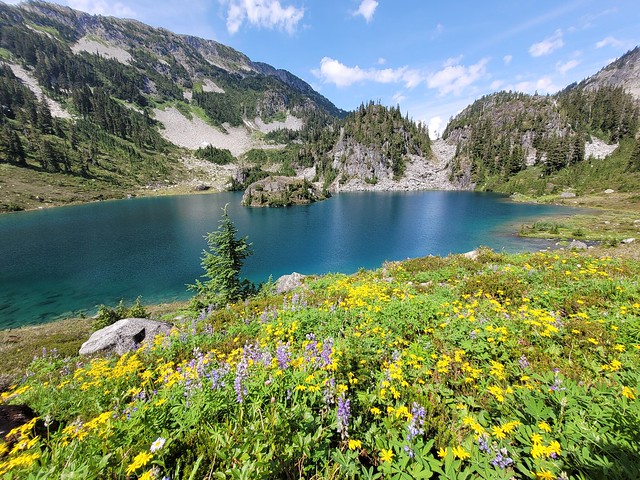
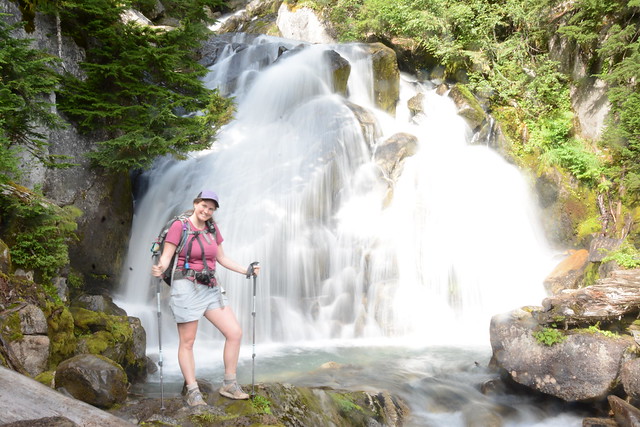
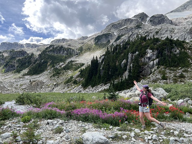
On VancouverTrails, it says it’s 7.5km to the lake, but my GPS tracked 9km and 900m of elevation gain, but I didn’t find this part of the trail difficult at all. The trail starts with a steep climb, then flattens as you walk through the trees along the river and past some waterfalls. Then you climb again up to the meadows where you meet the junction for the Skywalk South Trail. There’s an outhouse and a gorgeous view up to the glacier. It’s another 1km to the lake, which is the most technical part of the hike. You have to hike up through the boulder field to the base of the glacier. This was one of my favourite parts of the hike though because there were lots of wildflowers growing around the streams coming down from the glacier and it was very scenic!

IMG_1261

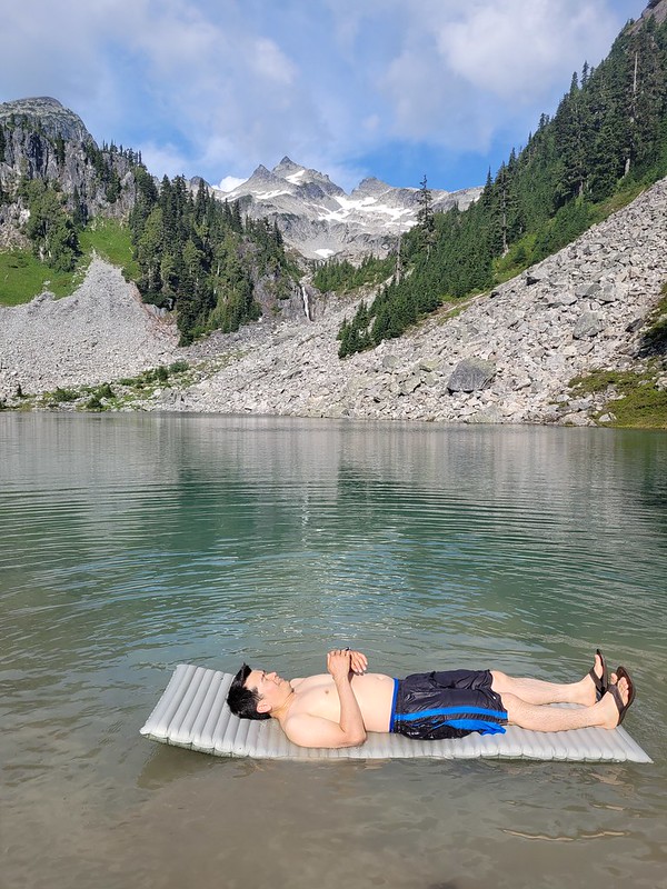
It took us about 3 hours to get up to Iceberg Lake. We barely saw anyone on the hike up to the meadows and once we left the lake, but it was fairly busy from the meadows to the lake. It was strangely cold on the day we visited though. Vancouver had been nursing a steady heatwave since mid July, but on the weekend we went, we got a brief cold spell and we had to layer up with fleeces and windbreakers at the lake. But not before I went for a swim!

20220827_124519

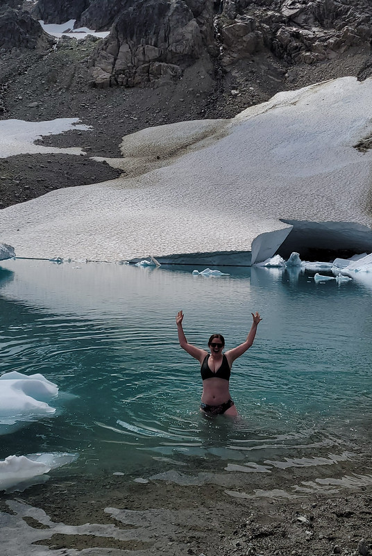
I pride myself on almost always going for a swim, no matter how cold the water is and this was no exception. I knew I was going to get cold fast once I stopped moving and my sweat cooled, so I stripped down to my swimsuit immediately. It was definitely some of the coldest water I’ve been in and I didn’t stay in for more than a minute. By the time I crawled out my body was already starting to go numb, but it was cool to briefly swim with all the bergy bits – that was a first for me!

20220827_123959

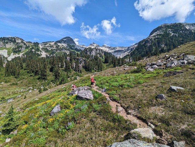
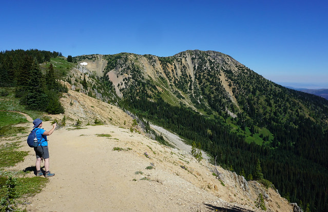
We hung out at the lake for a bit before continuing on. If you’re doing the South trail, you’ll have to hike back to the meadows, but the North trail climbs up over the pass on the right side of the mountain to continue into the sub-alpine. Unless you’re doing the shortest route (up and back on the Iceberg Lake Trail), I’d really recommend Skywalk North (though I haven’t done the South Trail yet). The hike up the pass was my favourite part of the whole hike because you get to look down on the lake and the glacier, which is a cooler vantage point than looking up on it.

20220827_140228

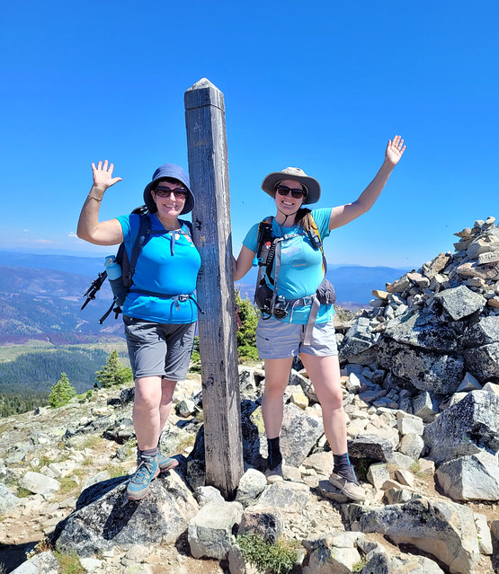
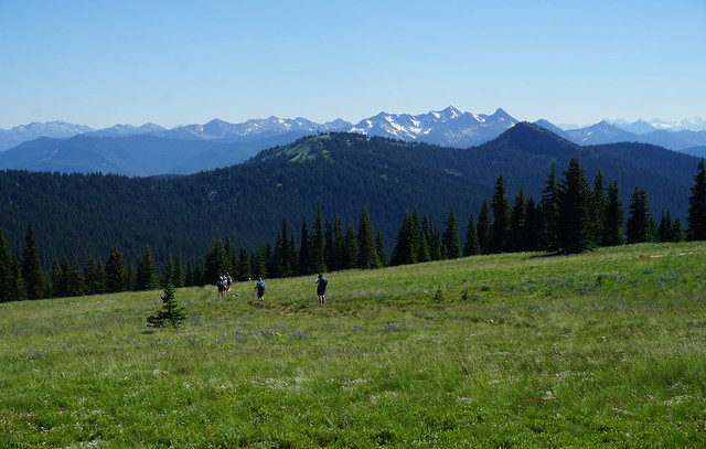
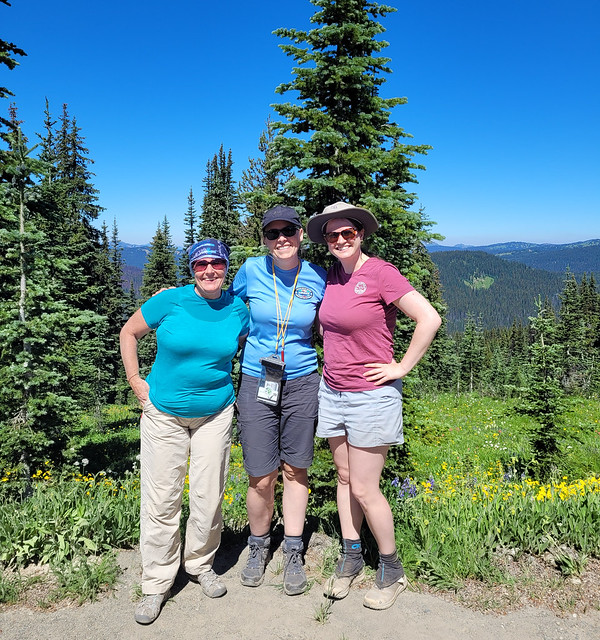
Once you get to the top of the pass, the trail flattens out again and you spend a lot of time hiking through meadow after meadow. We stopped at the top for a bit of a photoshoot and then took our time hiking down. What I liked about the North trail is that you get to spend a lot more time in the sub-alpine than if you just did the Iceberg Lake trail. There’s a great view looking out towards Whistler-Blackcomb, Wedgemount, and Pemberton and the alpine meadows were all in bloom with yellow arnica, purple lupins, white sitka valeria, and pink mountain heather. Plus by doing a loop you get to experience all new terrain!

20220827_141333

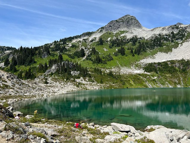
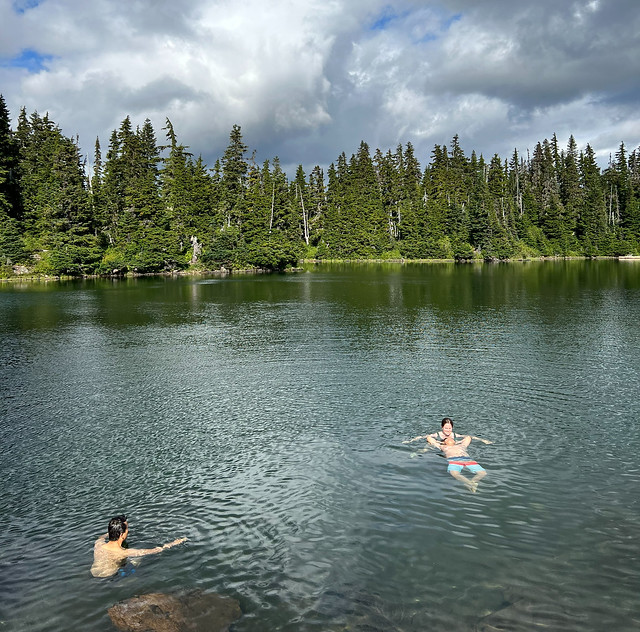
This part of the hike did take us a bit longer than anticipated. The down side to Berg Lake is that you eat your lunch when you haven’t done half of the trail, so it does make for a long afternoon. We hit Screaming Cat Lake around 4pm, which is a large lake before you start the downhill. I decided to go for a swim again and I was thrilled because Screaming Cat is not a glacial lake and is much warmer, so you can actually go for an enjoyable swim. It was still pretty cold, but once you got in, it was actually warmer in the water than out of it and we stayed in for a while, with both Lien and Brandon joining me.

HOP_7913

The rest of the hike was pretty painful for me. It’s been a while since I’ve done so much elevation gain in one day and my knees were starting to bother me. After Cat Lake you have to do about 850m of downhill, which gets progressively steeper. It’s still a very nice hike – the trees aren’t tightly packed, so the forest had a very sunny feeling, but my knees were both killing me. I got slower and slower and pretty much crawled down the last 2km. We added a bit more distance to take the less steep routes where possible to save my knees. Even still, it was just after 7pm when we exited the trail, which I thought was pretty good all things considered!

IMG_1334

We drove back to Squamish and had a delicious meal before heading back to Vancouver. I don’t think I got home until 11pm, so it was a very long day, but I really loved the hike! It’s a lot of work, but high reward and a lot of time spent in the alpine! Definitely recommend for those long summer days. Though I’d be wary of going on a really hot day – a lot of the hike is exposed and it’s a lot of climbing to do with no shade.

IMG_1289
HOP_7843

Hiking Tricouni Meadows

This might be my favourite hike of the year to date! I’ve been doing more exploring around the Squamish River area in the past few years and have had Tricouni Meadows on my radar for a while. I was keen to visit it as an overnight, but have almost exclusively done overnight trips this year and needed a break, so we opted to do it as a day hike instead. I was a little bit disappointed to have limited time to explore the area, but excited to get a taste because it is incredibly scenic!

The most important thing to be aware of with Tricouni Meadows is access. There’s a lot of mixed information about the forestry road on the internet, so definitely come prepared with the right vehicle if you want to drive the whole way to the trailhead. Conditions can vary year by year as well, so take this information with a grain of salt and check more recent sources if you’re doing this hike beyond 2022.

20220820_104456

Tricouni Meadows is located off Branch 200, off Squamish Valley Road. Squamish Valley Road is easily accessible and you drive past the bridge, the High Falls Creek Trailhead, and the hydroelectric facility, taking the right fork onto Branch 200. This is where things get variable. I’m no expert on vehicles, but Brandon is very knowledgeable and his assessment was that the road is in relatively good condition at this point. You don’t really need 4WD, but you may want a bit of extra clearance and good tires. SUV’s can likely handle it, but even the early part of the road isn’t in very good condition for cars. There was a station wagon stopped less a 1km in when we drove it that ended up turning around.

IMG-20220820-WA0129

The first 2 switchbacks are quite steep, but the condition of the road doesn’t require 4WD. Once you get up the switchbacks, the road really isn’t that bad for the first 7km. But if you want to get past the creek at km 7, you definitely need the proper set-up. There is a huge wash-out with a very steep and narrow dip in the road. Since it’s only 3km to the trailhead from here, most people had opted to park along the road and walk the rest of it. There were a lot of big trucks like the Ford F-150, that while they had high clearance, are very long and couldn’t do the washout without grounding out on the back.

IMG-20220820-WA0082

Brandon drives a Toyota 4-Runner – he sized up the washout for a few minutes and decided he could do it. Brandon loves off-roading and I did think he could probably do it, but I’m much more cautious and was nervous about this approach. He gave it a go, to much nervous yelling and swearing on my part, but was able to get down and out of it. He did ground out right on the back of his rear bumper, but there were no large rocks and so he didn’t get any damage. I think the shrubs actually did more damage to the vehicle as the road is very narrow and they were constantly scraping along the doors.

IMG-20220820-WA0053

In any case, the road still isn’t too bad after the washout until the last kilometre or so. It becomes very rocky after that and 4WD is definitely needed for the last portion of the road. But Brandon was thrilled when we finally made it to the parking lot to find we were only the 3rd car that had made it up there… and they were all 4-Runners! We’re pretty early in the day and when we exited the trail there were a lot more vehicles: 5 4-Runners, 2 Tacomas, and 2 Jeeps. So my recommendation would be to just park at the wash-out unless you are experienced. Honestly, driving up is barely any faster from this point, but it does conserve your energy.

20220820_125409

So with that out of the way, let’s talk about the actual hike, because it’s a really good one! There are two trails heading up along either side of high falls creek to Tricouni Meadows. They share one trailhead, but branch from each other almost immediately. The trail on the right (east side) is the original trail, which follows directly along the creek. This trail is known for being extremely muddy, which is why I suspect the second trail was developed. The second trail branches left (west side) and crosses the creek to ascend up to the meadows through the boulder field. It’s a slightly longer trail, but will take more than slightly more time because you go through the boulder field almost the entire hike.

20220820_132359

We opted to take the boulder field trail up and didn’t regret it. It’s a bit more technical, but it also has beautiful views of the mountains. There were still some wildflowers in bloom and we took our time since it was quite hot. The downside is, there’s very little shade and it is steep towards the end, so just take your time. It took us between 90-120 minutes to get up to the first lake.

I definitely recommend bringing 2 hiking poles for this hike because there are a lot of stream crossings. I managed not to get my feet wet by staying nimble, and Brandon kept his feet dry despite walking through the water because his boots are extremely waterproof, but Lien did get wet feet on some of the crossings. The first crossing when you start the hike is a bit tricky depending on water level, and then we crossed back over when we got to Pendant Lake, though this was an easier crossing.

20220820_153838

There are several lakes dispersed throughout the meadows. You can hike Pendant Lake, Spearpoint Lake, and Reflection Lake on your way up to Tricouni Peak, or Pendant Lake and Tricouni Lake on your way to Seagram Lake (requires wayfinding). We didn’t have much of a plan when we went up and stopped immediately at Pendant Lake to go for a swim and have lunch. Pendant Lake was probably my favourite of the 3, it has a beautiful little island in the middle and is shaped like a heart from above. The water was quite cold, but that didn’t stop me and Lien from taking a dip. Pendant also had a ton of wildflowers growing along the shore of the lake, which made it incredibly scenic!

20220820_134058

From there you hike up about 50m in elevation to get to Spearpoint Lake. This is the smallest lake, but has several flat areas to pitch a tent (something that’s mostly missing from Pendant Lake). We decided to save our swim in Spearpoint for later and continue up to Reflection Lake. Brandon floated around the idea of going all the way to the peak, but I didn’t really think we had time, so we decided to just start with Reflection Lake.

It’s another 100m in elevation gain to Reflection Lake, but the trail is infinitely more challenging. There’s not really a marked trail at this point and you pretty much just scramble up over the boulder field. There’s a beautiful waterfall, but it is very steep and not obvious where the trail is. Before the waterfall, you need to cross to the right side of the river and follow the landslide up to a cairn. This was by far the sketchiest part of the trail as it’s very steep and there’s a lot of run-out. I almost gave up and turned around, but decided to push on.

20220820_140213

Once you get up over the waterfall, there’s another boulder field, but it’s much easier to navigate and we soon made it to the lake. There are several creek crossings in between though, which is why I say to make sure to bring poles. There weren’t many campers when we arrived, but a lot showed up after us. Some set up at Spearpoint Lake and a lot were continuing up to Reflection Lake. Unfortunately there’s not a lot of flat spots anywhere really, so I recommend coming early and being prepared to get creative. Personally, I wouldn’t hike my big pack up to Reflection Lake.

IMG-20220820-WA0066

We abandoned the idea of going to the peak and instead chilled at the lake while watching other hikers start up over the scree. Despite the scramble up to the lake, I would say the view from Reflection Lake is worth it. You can see all the way to the peak from there – it’s very exposed alpine scree and boulder field. I’m not super keen on going all the way to the peak now that I’ve seen it, because there is limited trail and it’s mostly a technical scramble, but I could probably be convinced (likely by Brandon) to return and attempt it on an overnight trip (camping at one of the lower lakes). Instead, we had some more snacks and went for a swim in Reflection Lake, which is definitely the coldest of the three.

20220820_145847

There were a lot of mosquitoes when we visited, so be prepared for that. Brandon invested in a thermacell after we got eaten alive at Assiniboine last year and I have to say that it is worth every penny! We never go anywhere without it now and it made hanging out at the lake much more enjoyable. Brandon has the rechargeable one, which I think is the most effective, but I have the backpacking version (which uses isobutane) and also really like it – honestly you can’t go wrong with either!

IMG-20220820-WA0122

Of course, hiking back down was more nerve-wracking than the hike up, though more straightforward in terms of route finding. We stopped at Spearpoint Lake this time to go for our last swim of the day. Me and Lien swam in all 3 lakes, but Brandon just dipped in at Spearpoint. They’re all cold, but Spearpoint is the smallest and therefore slightly less cold than the other two. At this point there were A LOT of people exploring the area and the campsites, which were totally empty when we arrived, were completely filled up. We weren’t particularly early (starting the hike just before 11am), but it makes a big difference in getting a good site, so I recommend going earlier rather than later. There are no facilities though, so come prepared to dig catholes and I strongly recommend a bear can or bear bag as there are no good trees to make a cache.

20220820_162552

I’m definitely keen to return and spend a few days in the area, there’s a lot to explore! I’d like to visit Tricouni Lake and Seagram Lake, but it was too much for 1 day hike. It was around 5pm when we left Pendant Lake and we decided to take the muddy branch back to the car in hopes of saving some time.

The trail starts off pretty well and it’s definitely faster than descending through the boulder field. There are several mud pits along the way, but they were relatively dry and easy enough to walk over, so I didn’t get too muddy. Overall, the first 2 thirds weren’t too bad, but the last third was definitely a sloppy mess. I was ankle and calf deep in a few places, so I can only imagine how muddy it would be in the wet season (it was mid August when we went). I would only attempt the muddy trail in the height of dry season – otherwise stick to the boulder field. That said, it’s definitely faster and it only took us an hour to get back to the car.

20220820_132815

All in all, I loved this hike! It’s not the easiest to visit because of access and it has smaller crowds than a lot of popular hikes, but there were definitely more people there than I was expecting, so I think it’s growing in popularity. In addition to the mud, there are a lot of stream crossings, so I’ll probably stick to this one during the dry season, but I can’t wait to go back again!

IMG-20220820-WA0075

3 Brothers Mountain Backpacking Trip

The longer I live in Vancouver, the more I start repeating trips. This was my third time hiking to 3 Brothers Mountain (though each trip has been very different), but it was also probably my favourite trip! I’ve had a love affair with Manning Park for a long time. 3 Brothers Mountain was my very first hike in the park back in 2016 and while everyone else has been trying to bag every peak in Garibaldi Park, I’ve been working on bagging every trail in Manning. I day hiked the trail with Emily in 2016 and returned in 2018 with Carolyn to thru hike the Heather Trail over 3 days. On this occasion, I visited with my Girl Guide troop and we set up a base camp at Buckhorn Campsite for 3 days.

20220729_144700

This is my first year with a Trex Unit – which is a special girl guide unit focused entirely on outdoor adventure. For our first year, we decided to do a backpacking series. Our first trip was to Viewpoint Beach in May, which had moderate success due to all the rain, so Trex was very excited about the potential nice weather for this trip!

Unfortunately, with it being summer and people going on holiday, we had a small group, with just 5 girls, but their enthusiasm more than made up for it! They are very keen to hike Panorama Ridge one day, but we decided we needed a bit more practice in the backcountry before we attempted that hike. Which was an excellent decision because with the high snow pack this year, Panorama was still buried when we attempted this hike. In addition, my friends went up to Garibaldi the same weekend and ended up getting evacuated when the water levels rose into the campsite, so all in all, we were thrilled to be at Manning Park instead!

DSC00556_2

That said, we were still up against some challenges in Manning Park as well, particularly the heat. After my companion got evacuated from Banff National Park last year with heat stroke, I’ve been very weary about hiking in hot weather. But heat waves are starting to become more and more common around here, so I’ve had a lot of learning about staying hydrated over the past year. It was calling for 28 degree temperatures on the 3 Brothers hike, so we decided to go anyways and packed in a lot of electrolytes with us.

20220729_145029

We gave each member a 1L bottle of gatorade before we left the lower mainland and they were tasked with drinking as much as they could before we started hiking. Traffic was brutal leaving Vancouver on the August long weekend, so they had a lot of time in which to accomplish this task, though it turned them off gatorade in the process. But we were nice and hydrated when we started.

Even so, it was a bit of a slog doing the 4km to the campsite. It was around 1pm when we pulled into the parking lot on Blackwall Road, so we ate our lunch there before starting our hike. Luckily it’s all downhill on the first day, so we took our time since everyone had heavy packs. We weren’t sure if it was going to be too early for the wildflowers with the late snowpack, but fortunately the meadows were in full bloom! We stopped several times in the shade on the way to the campsite, but still made fairly good time.

DSC00605_1

When I hiked the Heather Trail, I went the full 13km to Kicking Horse Campsite on my first day, so I’d never stayed at Buckhorn. I thought it was a small site with a few tents pads, but I’d obviously never taken the time to explore it because it is a massive campground with 24 tent pads and a gorgeous sheltered cooking hut! I think it’s probably expanded since I was there in 2018 though because a lot of the tent pads looked very new.

Trex found a few tent pads next to each other that they liked, but they weren’t shaded, so the Guiders set up in a different area. We did some exploring around the campground before settling in the shelter for dinner. There were some mosquitoes around, but definitely not as bad as other campsites I’ve been to this year. For our first meal we had Mexican rice on tortilla, which was a huge hit!

DSC00623

On Day 2 we packed our bags for a day hike up to the First Brother Mountain. This was the unit’s first major trek and we had a few growing pains at the beginning. The girls were not happy when I insisted that they each had to bring a full 2L of water on the trail. I don’t think they realized the extent of the hike and the term “day hike” had given them the distinct impression that it would be easy. So I think they learned a lot!

We were glad to be doing the climb up to the mountains early in the morning and we were all in awe at the huge fields of wildflowers along the route! It’s pretty route, so we took short breaks in every shady spot and a few longer snack breaks. In addition to gatorade powder, we all had packets of iced tea and pink lemonade to mix into our drinks. This was really helpful in encouraging the girls to drink more as not everyone loves drinking water. Even still, it was very hot and I wasn’t sure if we would want to push all the way to the top of the mountain. We decided to continue trekking to the bottom of the First Brother to assess from there.

DSC00611_1

Because I still have some PTSD from the heat stroke incident, I didn’t want to pressure anyone to hike all the way to the top and gave the group lots of opportunities to turn around. But everyone was determined to summit, so we took a break at the base and started hiking up in groups. We stressed the importance of taking lots of breaks and that just because we were going to try for the summit, didn’t mean we couldn’t change our mind at any time. I opted to go last so that I could turn around with anyone who was having reservations (pretty much just me, lol).

20220730_132851_01

Fortunately everyone did amazing! Iris hiked halfway along the ridge, but opted not to go all the way to the summit because of her fear of heights, but all the Guides went right to the top! There’s not much vegetation up there for shade, so we quickly did our best to get a tarp up with our poles so that we could have a bit of shade to eat our lunch. Even though it was my third trip to the top of the mountain, this occasion was extremely rewarding because I was so proud of the group! They were all thrilled with their success and I loved watching them get that sense of accomplishment and satisfaction that comes with pushing yourself to achieve something new and scary.

20220730_132444

Just as we’d hiked up in small groups, we returned back down in small groups as well. I came last again and had a good chuckle when I caught up with the group, to find everyone sheltered under the one lonely tree that was providing shade on the ridge! We took a break here before heading back down. The lesson about packing lots of water was learned as everyone expressed their amazement that they had drank so much! We were even starting to run a little low, but we’d seen a few streams on the way up, so we decided to return to those to filter more water.

DSC00653_1

There’s a small pond on the way back and we all dipped our hats in the water to cool down. The streams were really just a trickle, but we were able to filter about 5L, which was enough water to see the group back down to the campsite. The girls really powered it on the way back and beat the Guiders by a longshot. We took river baths and had a little nap before heading to the cooking shelter for supper, where we discovered the Guides had already fed themselves and were making dessert for us!

DSC00688

So overall, I was super impressed with how everyone handled themselves on the hike in the heat. There was no complaining and everyone got up early the next morning so that we could try and beat the heat on the hike back uphill to the parking lot. You can see the First Brother Mountain from the parking lot and there was a real sense of accomplishment that we had hiked all the way there and back! So in conclusion, 3 Brothers Mountain remains one of my favourite hikes – I think it’s a great hike for beginners and it was a real pleasure to share this hike with the Girl Guides!

20220731_112902