On my second day in Ortisei, I decided to hike the Alpe di Siusi, another very popular hiking area in Val Gardena. I would say it’s the second most popular area after Seceda. I debated whether I should do either hike, since they’re both so popular, I thought they might be overrated. I did Seceda on my first day and absolutely loved it, so I decided to just stick with the popular hikes and do Alpe di Siusi on my second day.
The weather was pretty hit and miss on the day I hiked the Alpe di Siusi, so I didn’t enjoy it as much as Seceda. It’s a beautiful area, but I did find it to be a little underwhelming compared to some of the other scenery I saw on this trip. I’m sure this was just a result of hiking fatigue or the poor weather or that it Fall and the meadows were a little past their prime. It was also towards the end of my trip and I think I was just over it at that point.
The Alpe di Siusi is essentially a high altitude plateau. If you’re visiting from Ortisei, you can take the Mont Seuc gondola right out of town. Ortisei is in the valley, so you ascend to the top and then you can spend the rest of the day walking around the plateau. However, the vibe is different from Seceda. Seceda is only accessible by cable car or foot, whereas the Alpe di Siusi plateau is accessible by car if you’re coming from the Seiser Arm. So you will see cars and buses driving around while you’re hiking. There’s also tons of hotels and restaurants up there, so it feels more like a walk than a hike. It’s not uncommon to explore the area by bike if you’re coming from Seiser Arm.
But I was coming from Ortisei, so I ended up planning out a 12.5km loop around the area. I’ve shared a map of my route below. My recommendation is to plan your route before you go because it’s not intuitive where to go otherwise. There’s no obvious hiking trail and a lot of my walk was on the roads. If you don’t plan in advance, it can be a little bit confusing about where to explore.
I did a counterclockwise loop from the gondola to Saltria, stopping for lunch at Rauchutte. Again, I started my walk early in the morning to get the first gondola and there was no one around when I started hiking. It was raining when I started my walk, but the weather improved throughout the day, so starting later might have been a little more beneficial as I found the hike out of Saltria to be much more scenic than my morning walk because the sun brightened everything.
If I’m being honest, the most challenging part of this trail for me was finding somewhere to pee. There are quite a few hotels around, but my timing wasn’t great and there’s really no privacy to pee in the bushes along the trail, so plan accordingly. There were lots of horses and cows in the meadows out of Saltria, which made for a scenic afternoon.
Similar to Seceda, there is a lot of elevation gain hiding on this hike. You start from the highest point and hike all the way down to Saltria, so it was a more tiring walk on the way back to the gondola. I covered 400m of elevation gain over 12.5km (compared to 500m over 10km at Seceda), so it was still an easier trail.
While I didn’t enjoy Alpe di Siusi as much as I thought I would, I wouldn’t count this walk out. I think my experience was likely due to a combination of poor weather and fatigue. I hiked for around 4 hours, including my lunch break and then I took the gondola back down to Ortisei. There’s a big climb up to the gondola at the end of the day, so make sure you save a bit of energy for the end. Overall, it’s still a very beautiful area, but given the choice between Seceda and Alpe di Siusi, I would prioritize Seceda.
As someone who grew up on the East Coast, Fall was a very beautiful season. I love living in Vancouver and I would say that seasonally, the west coast is nicer than the east coast in almost every season (winter and spring for sure, summer less so with the forest fires), but Fall is conclusively better on the East Coast. At least, compared to Southwestern BC. If you want sweeping forests of red, yellow, and orange, you likely won’t find it here – there’s too many Douglas Firs and Cedars, but there are still some gorgeous views to explore, especially with a mountain backdrop. Here’s a few of the trails I’ve discovered over the years that really shine in the Fall:
Fall Colours near Vancouver
Mount Strachan – 8.5km, 600m gain
I wouldn’t say Mount Strachan has the most outstanding fall foliage, but it’s the closest hike to the city on this list, which makes it very accessible! The colours on this trail mostly come from the changing colours of the shrubs and it’s a great hike on a crisp Fall day. Get on the Baden-Powell Trail from Cypress Resort and hike parallel to Collins ski run. Then follow the sky chair up to the top of Mount Strachan to enjoy beautiful views of Howe Sound. From here, you can continue back the way you came, or you can make it a loop and hike down through Christmas Gully to catch up with the Howe Sound Crest Trail, checking out the views from Bowen Island Lookout on your way back. Make sure you pick up a free backcountry pass from the BC Parks lodge (at the back of the parking lot) before starting your hike. Take care on Christmas Gully when descending from Mount Strachan, it is easy to get lost or injured here. (photo taken in mid-November)
The Flatiron hike is located in the Coquihalla Summit Rec Area and shares 80% of the trail with Needle Peak. Both trails could be done in a day if you’re ambitious, but I’d avoid Needle Peak if there’s any snow or ice. It’s a very steep hike up the side of the mountain from the highway, but once you reach the branch to Needle Peak, it levels off. There’s a nice lake below the flatiron and in the Fall the shrubs all turn bright red along the mountainside. It’s relatively bare at the top, but the view of the surrounding mountains is amazing! (photo taken in early October)
This is a more traditional Fall trail and there are deciduous trees that will be changing colour as you walk through the forest toward the summit. Most of the hike is in the trees, but you eventually pop out along the ridge. It’s a steep hike near the end, but you can see all the way to Mount Baker, with bursts of colour in the forest below. I really like continuing a few kilometres along the ridge towards Thurston Mountain, but the peak itself is pretty uninspiring, so I usually turn around when I hit the forest. The hike is 9km to Elk Mountain and back, and 15km to Thurston. There’s over 1000m of elevation gain, so it’s a good workout! (photo taken in mid-October)
This trail is a bit of a drive and makes for a long day as a day hike, so start early! Illal Meadows is located off the highway along the Coquihalla Summit Rec Area and involves an extra half hour of driving along the Tulameen FSR. The trail starts with a 3km hike up a decommissioned road, and then it’s a steep ascent through the meadows to the alpine. There are lots of small trees and shrubs changing colour and the meadows turn yellow and red. Continue to the base of Jim Kelly Peak, where you have the option to do an additional ascent (it’s a scramble!) or head back the way you came. (photo taken in late September)
Snow Camp Mountain – 17.5km, 900m gain
This is a beautiful hike any time of year. In the summer, the meadows are filled with wildflowers, and in the Fall, the meadows turn yellow and have gorgeous views looking out over the Manning Park backcountry. The trail starts from Strawberry Flats and hikes steadily uphill for 5km. There’s a fantastic viewpoint at the top of Despair Pass, but continue on through the trees to reach the ridge going up to Snow Camp Mountain. I find this trail doesn’t get crowds in the Fall and is a really gorgeous hike. (photo taken in mid-September)
Larch Tree Hikes
If BC isn’t known for it’s Fall colours, it’s definitely known for the larch trees! Larch trees have needles like a pine or fir tree, but these needles turn yellow in the Fall and fall off. There are some really beautiful larch tree hikes on the West Coast. Most of them are located in the Rockies or Washington State, but if you’re willing to drive a little distance, you’ll be rewarded! In the interest of transparency, the only hike in this section I’ve actually done in the Fall is Mount Frosty, the other trail descriptions are based on trips I took in the summer. That’s why my photos don’t show any Fall foliage.
This is probably the most well known larch hike in the province, mostly by virtue of the fact that it’s close to Vancouver, so it attracts very large crowds. Definitely arrive early in the morning to get parking and get ahead of the mass of people (or go on a week day). The larch trees generally only turn yellow over the span of 2-3 weeks, so you can expect it to be busy during that time. Frosty Mountain itself is a really big hike, but you don’t have to go all the way to the summit to see the larch trees. After a big climb up to the campsite, you’ll eventually pop out in the larch meadow. But continue to the top of Mount Frosty for some really epic views! (photo taken in late September)
The Sentinel Pass trail is a really popular trail in Banff National Park and requires a bit of advance planning to visit. The hike starts from Moraine Lake, which is one of the most popular locations in Banff. You can no longer drive to the lake, so you need to arrange to take the Parks Canada shuttle. From the lake, hike up a set of switchbacks to reach the larch meadows and continue on towards Minnestima Lakes. You don’t have to hike to the top of Sentinel Pass, but it’s a nice add on to enjoy the views looking back towards the lake and the surrounding Mount Temple area. It’s roughly 3.5km to reach the meadows, or 12km round trip if you go to the top of the pass and back. (photo taken in early August)
I would say that Floe Lake is the Moraine Lake of Kootenay National Park. It’s extremely popular, though much less accessible as you can’t drive all the way to the lake. This is a big hike for a single day, so I’d recommend camping one night at Floe Lake if you’re able. That said, it’s a big uphill to the lake and would likely be considerably faster with only a day pack. The larches are actually located above Floe Lake, so you’ll be rewarded with the beautiful view at the lake, but need to push another 3km uphill after the lake to be rewarded with a view of both the larch trees and Floe Lake. In total, be prepared for an almost 30km day, so leave before sunrise. (photo taken in late August)
Of all the hikes on this list, Lake O’Hara is probably the most exclusive. There’s a permit lottery for bus shuttle passes up and down the 11km access road. You can hike all the way from the base if you’re prepared for an almost 30km day (like Floe Lake), otherwise, the shuttle saves you a lot of time. From the bus stop, you can do a 7km loop around the lake and up to the Opabin Prospect Lookout, which is the most renown view in the park. If there’s no ice, you could also consider hiking the famous alpine circuit, but I wouldn’t attempt it on a slippery day and you might prefer to have more time to enjoy the larches around the lake. (photo taken in early September)
Hiking Near the North Cascades
One of my favourite things to do in the Fall is cross the border and go hiking in the Mount Baker Wilderness area of Washington State. If you drive a little further into the cascades, there’s some really awesome larch hikes like Maple Pass, Blue Lake and Easy Pass. I haven’t done any of these yet, because there are so many colourful hikes to explore closer to Vancouver by Mount Baker.
As a disclaimer: I wrote this blog post at the end of last Fall season. I personally have decided not to travel to the US right now (but I really hope to feel safe doing so in the future). It’s out of my personal comfort zone right now, but no judgement either way, here are some of my favourite Fall hikes south of the border.
These two trails share a trailhead from the ski parking lot at Mount Baker. Grab a parking pass online before crossing the border, or pick one up from the visitor centre. If the road is open all the way to Artist Point, park at the top and do the Ptarmigan Ridge hike. If the road is already closed for the season, park at the base and do the Chain Lakes Trail. Both hikes go up towards Artist Point and cross a ridgeline into the backcountry. The Ptarmigan Ridge trail heads out towards the base of Mount Baker, while the Chain Lakes trail goes behind Table Mountain and climbs to the top of a saddle before heading back down to the base. Both hikes are incredibly scenic and colourful in the Fall. Chain Lakes is a 12km loop trail, while Ptarmigan Ridge is 19km out and back to the Portals viewpoint. (photo taken in mid-October)
Yellow Aster Butte has gotten incredibly popular in the past few years. Pick up a parking pass online or at the visitor centre, and then drive up a gravel road to get to the trailhead. There’s limited parking, so get there early to avoid the crowds. The trail climbs up through the trees for 3km before you reach the alpine and the beautiful yellow aster meadows. It’s 3km further to get to the sub-peak, and another 1km from there to the true peak. This area can get snow early, so plan accordingly. (photo taken in early October)
Winchester Mountain is the final hike on the list, and the only trail that requires 4×4 to reach the trailhead. This trail starts at the campsite for Twin Lakes and hikes up to the peak of Winchester Mountain, where there’s an old fire lookout. The trail is only 5.5km round trip and is located past the parking lot for Yellow Aster Butte. So if you don’t have 4×4, you could add on 3.5km to hike up the road each way (or try and hitch a ride on the way up). The entire trail hikes through colourful meadows while the trees change colour. It’s an easier hiking option with a huge payout. (photo taken in early October)
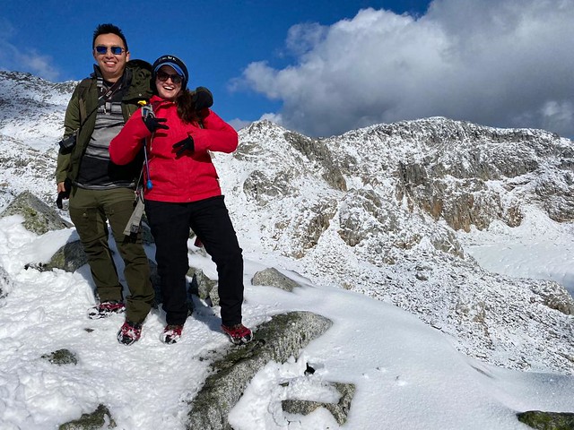
Over the years it’s become a bit of a tradition that me and Brandon always go hiking together on the Thanksgiving long weekend. The forecast was calling for gorgeous weather on Thanksgiving Monday, so we got to planning where we wanted to hit up this year. Brandon had a long list of hikes to try, but once we started doing a bit of research, we found it to be a bit challenging to find a suitable hike for the conditions.
Because I believe in always putting ample research and consideration into every hike you do, I’ll walk your through our process. First we crossed off some of the longer and more strenuous hikes from Brandon’s list. One of the hikes was a whopping 1800m in elevation gain and we were concerned about having enough daylight hours to do such a long hike. Next we took into consideration the weather. It had been uncharacteristically cold the week previous and in true Vancouver fashion, it had rained all week. A bit of research confirmed our suspicion that many of the local peaks were now covered in snow. Brandon was keen to do Tricouni Peak outside of Squamish, but the two routes up to summit involve either fording 2 creeks, or crossing what is described as the “mud gauntlet”. Both of these options sounded like a bad idea given the amount of rain that had fallen earlier that week and the peak was still quite high in elevation (meaning more snow), so eventually we landed on Seed Peak.
4WD access road to the trailhead (E110)
Seed Peak is a less trafficked trail off of Mamquam FSR in Squamish. It was 300m lower in elevation than Tricouni, and while we knew there would still be snow, we guessed the access road would be snow free and overall make for a shorter, less strenuous hike. After having done the hike, I wouldn’t say it’s not strenuous, but hey, that’s how we ended up giving it a try!
Mamquam FSR is in good condition and any vehicle should be able to make it to the end of the road. AllTrails actually lists this hike as 19.5km starting from the end of Mamquam FSR. Brandon hates hiking on anything he could have driven, so we took his 4runner a fair bit further than that. From the end of Mamquam, you branch off onto E100 and then E110 to get up to the trailhead. E100 is a bit steep at the beginning, but still in pretty good shape, I think most SUV’s and AWD could make it up to the end of E100. We were able to get Brandon’s car all the way to the end of E110, but I would advise hiking up the last little switchback (about 300m). There’s a pullout before a steep rugged section and I didn’t think it was really worth risking the drive up that part.
Logging at the trailhead
I would only recommend Seed Peak if you have good wayfinding skills. It’s pretty intuitive to know where to go, but there are parts without a well defined trail (and some parts with no trail), so if you’re hopeless with navigation I’d give it a pass. The most confusing bit for us was finding the trailhead. This is an active logging road and there has been some slashing between the road and the trailhead, which run parallel one another for a few hundred metres. I suspect they weren’t supposed to log onto the trail, but it looks like it happened nonetheless. We did some crawling over the logs to try and get to the trail, only to miss it entirely and then hike up the edge of the slash until we found trail markers. My recommendation would be to walk right to the very end of the road, from there you’ll see a trail marker, you may have to climb over a few logs, but you can pick up the trail a lot easier from there rather than trying to cut across all the downfall.
After that it’s pretty easy to follow the trail markers up about 1km to the sub-alpine. This was the only part of the trail that didn’t have snow on it when we did it. The snowline started around 1400m. The great thing about this hike is that only the first 1km is in the woods, after that you have views for pretty much the entire hike! It was the main reason we picked it, because we figured if the conditions were too bad or snowy to do the whole thing, at least we still had a good chance of seeing some nice views early in.
It is a challenging trail though. It’s not been the easiest hiking season for me as I’m still pretty out of shape from the pandemic with all my normal exercise activities still being cancelled (or high risk). It’s 12km round trip to the top of Seed Peak, but the elevation gain is misleading as there is a lot of up and down and it is quite steep. Fortunately we were prepared with microspikes as we definitely couldn’t have done the trail without them given how steep it is. I was a little bit concerned as we were going up that it would be a struggle to come back down, but it was manageable with the spikes.
After you pop out of the woods, you immediately start a steep climb up to the first peak. I can’t see a name for this peak on Gaia, but it has great views if you’re looking for a shorter hike. It’s very flat on the top, so we wondered around snapping photos before continuing on. This trail is also known as Pinecone Trail, so you might see it listed as that on some trail apps (Gaia included). The reason it’s called Pinecone Trail is because after the first peak, you cross the border into Pinecone Burke Provincial Park! I was particularly excited about this because I live in Coquitlam and go hiking in Pinecone Burke all the time.
For a bit of history, Pinecone Burke was first established in 1995 and has the unfortunate legacy of being one of BC Parks least funded parks. Despite it being a huge park located right in the lower mainland, it receives very little upkeep or promotion. Most of its users access it from Harper Road on Burke Mountain and it’s popular for mountain biking. There are a handful of trails in that area, but otherwise the park is mostly wilderness. It’s sandwiched between the Coquitlam Watershed and Pitt Lake in the south end, and continues north until it intersects with the south end of the much more popular Garibaldi Park. There’s limited access in the north end and Seed Peak is one of the only trails I can find exploring this end of the park, so I was excited to see a completely different side of it.
After the first peak, the trail has a steep false descent, after which you climb up to a second smaller peak before beginning the real descent. We were one of 4 groups on the trail, so it was very empty. However, we were the last group, so we didn’t have to make tracks and just followed the trail the previous groups had created. This may or may not have been a good thing. Whether or not there is an actual trail in the summer is hard to tell when it’s covered in snow, so we don’t know how much we were actually walking on the real trail and definitely went through some vegetation. The upside is that all the rocks were covered in snow, so we didn’t have to navigate any boulder fields and mostly just cut a path straight down. We were definitely in the vicinity of the intended trail (according to my GPS), but I’m not sure if it would be any easier on a warmer day.
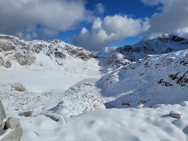
The descent is a bit of a bummer when you know you have to continue climbing again. As you start to climb up the next peak (also unnamed on my GPS), you do get a few glimpses down to the beautiful jade waters of November Lake. It was a bit of a slog going up, but you’re surrounded by beautiful views on all sides. Unfortunately, there’s still one more peak to go after that. It took us about 2.5 hours to make it to this section, we continued a little bit further to get up to this hump before Seed Peak, but we opted not to go the whole way up Seed Peak. We did have enough time, but we could tell it was still a bit of a slog to get up there and we wanted to conserve some energy for the way down. So instead, we had a nice long lunch break in which to enjoy the view!
If you do go the whole way, I think you get a view down to Pinecone Lake, which you can’t see from below because there’s a big ridge between Seed Peak and Mount Gillespie that blocks it. But there are still incredibly gorgeous views down into the valley and the snow-covered wilderness. I’d definitely be keen to return in the summer and camp along the ridge, although there’s limited water sources so you would have to come prepared for that.
Either way, we had a great time hanging out and filmed some fun videos to pass the time. It was definitely cold; I had a lot of layers, so my body was warm, but I had worn my hiking boots instead of my winter boots and unfortunately my feet did get wet from the snow getting trapped between the sides of my microspikes.
We thought it might take us even longer to hike back because really steep sections are often worse on the downhill, but fortunately it wasn’t too bad and we cut about a half hour off our time on the way back. I was exhausted on all the uphill sections though, so I definitely need to start doing a bit more exercise on my non-hiking days. The trickiest part is that there is one rope section on the first peak (early in the hike). It’s even worse going down and we all guided each another on foot placement on the way back. I had been debating bringing Sadie on the hike with me, but I’m glad I didn’t. We read there was one rope section and I was worried about her on that part and with all the snow. I think a dog could get up the rope section, but I honestly don’t know how you would get them down. Overall there’s a lot of narrow edges and cliffs, so I would have been very weary with Sadie. I would likely have to let her off leash for my own safety in sections and I’d be worried about her making a mistake near a cliff edge. Also, we saw a GIANT black bear on the drive in, so they are definitely still active.
Overall, we were hiking for just shy of 6 hours, so it was a great end-of-season hike. It’s about an hour drive from Squamish and we made it back to town around 5pm. The downside was there was an accident on the Sea-to-Sky. We had dinner at Howe Sound Brewing to try and avoid the traffic back-up, but it had only gotten worse and we ended up sitting at a standstill for 45 minutes. I think it was shortly after 9pm when I finally made it home, making for a bit of a long day! Either way, I’d recommend checking out this hike earlier in the season next year if you have 4WD or high clearance and like a challenge!