If you’ve been following my blog for awhile, you might be aware that I first attempted to visit San Josef Bay in 2020. I backpacked both the Cape Scott Trail and the North Coast Trail in June 2020, but thanks to a series of misadventures at the start of my trip, I had to cut San Josef Bay from the itinerary. A few years ago I saw San Josef Bay ranked on a list of the “most beautiful beaches in the world” and it’s been haunting me ever since that I still haven’t been there!
So this was a bit of a redemption trip for me. Over the Easter long weekend in April, I decided it was finally time to tackle San Josef Bay. It’s located on the far eastern coast of Vancouver Island and it is a journey to get there. I left Vancouver on Thursday after work with my husband, Seth, and our anxious Australian Shepherd, Sadie. We had a reservation on the 6:30pm ferry, which was absolutely necessary because the ferry sailings were already completely sold for the whole day by the time we arrived at the ferry terminal. Unfortunately, our sailing was delayed by almost 2 hours, meaning we didn’t get to Nanaimo until almost 10pm.


I’m a hyper-planner when it comes to trips, but this was one of the rare times where I didn’t have a booking for the night. I’ve been trying to embrace the unknown a little bit more and take advantage of FCFS and rec sites. We’d been hoping to drive to Campbell River before finding a place to sleep, but given the late hour, we drove ~30 minutes to Little Qualicum Provincial Park in search of a site instead. We were able to secure the second last campsite and quickly put up the tent to catch some sleep before continuing the journey in the morning.
We were up early to finish the 1 hour drive to Campbell River, followed by 2.5 hours to Port Hardy. Our friend Victoria was also joining us with her friends from Victoria, so she walked on the first ferry on Friday morning and they picked her up on their way north. They were a little bit behind us, so we stopped for a nice lunch at Cafe Guido in Port Hardy. It was an excellent choice because they also have a bookstore and artisan craft shop in the same space! So we picked up some souvenirs before finally meeting our friends and their Australian Shepherd, Daisy, to continue the journey.

We already had 4 hours of driving behind us, but we still had the most challenging part of the trip ahead – the Forest Service Road to San Josef Bay. Considering that Port Hardy is on the east coast of Vancouver Island and San Josef Bay is on the west coast, it’s pretty impressive that there’s a 65km gravel road extending the entire width of the island. Despite it being a gravel road, it’s not in terrible condition – you can do the entire drive in any vehicle, you don’t need 4WD or high clearance. That said, the road isn’t in great condition either! If you want to avoid the drive altogether, there is a shuttle that runs from Port Hardy.
The last time I did this road, Brandon was driving way too fast and got a flat tire 30 minutes in. This wouldn’t be the end of the world, but his mechanic had put the wrong lug nuts on his tires, so it left us entirely unable to change the tire. This devolved into a 24 hour expedition involving hitchhiking, sleeping on the FSR, and paying a mechanic to break all the lug nuts off. I really wanted to avoid any flat tires this time around, so we drove pretty slow. The first 30km of the road are in reasonable condition, but the last 35km have a continuous stream of potholes that make gaining any kind of speed risky. I’d say we averaged ~30km/h along the road, so it took us around 2.5 hours to get to the trailhead parking lot – with no flat tires!


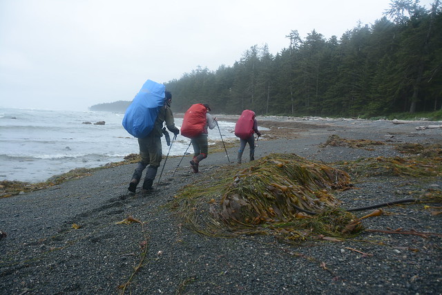
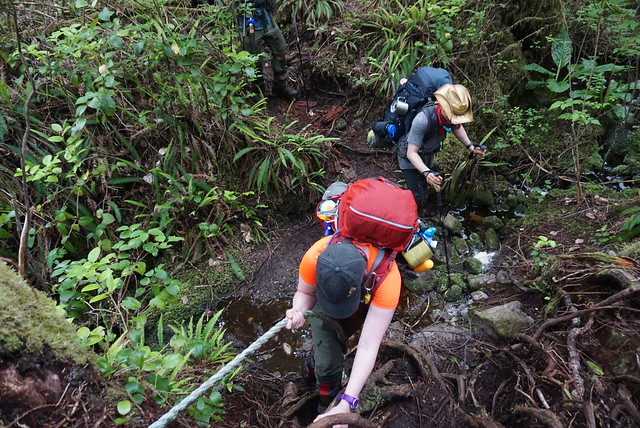
From the parking lot, it’s a 3km hike along a well-maintained trail to San Josef Bay. Me and Seth backpacked, but Victoria and her friends had a very special “Swagon Wagon”, which they used to transport some more luxurious camping equipment! The first 1km of the trail is a shared route into the park, after which there is a branch. If you go right, you can hike 23km to the Cape Scott Lighthouse, or 60km to the end of the North Coast Trail. This is the trip I did in 2020. But if you turn left, it’s another 2km along a leisurely trail to San Josef Bay, one of the most beautiful beaches in the world!
The trail itself is gorgeous. We had a pretty late start, around 6:30pm, but it only took us an hour (even with the wagon) to hike through the forest to the beach. Along the trail, I was reminded why the north coast of Vancouver Island is such a special place. Like most of BC, it’s second growth forest, but you can still see lots of old growth trees scattered throughout. Somehow, these trees have withstood the test of time and it’s truly humbling to stand beneath their gigantic trunks, so I really enjoyed the walk to the beach. Although my shoulders were hurting – I also took advantage of the short distance to pack a few of my own luxury items!


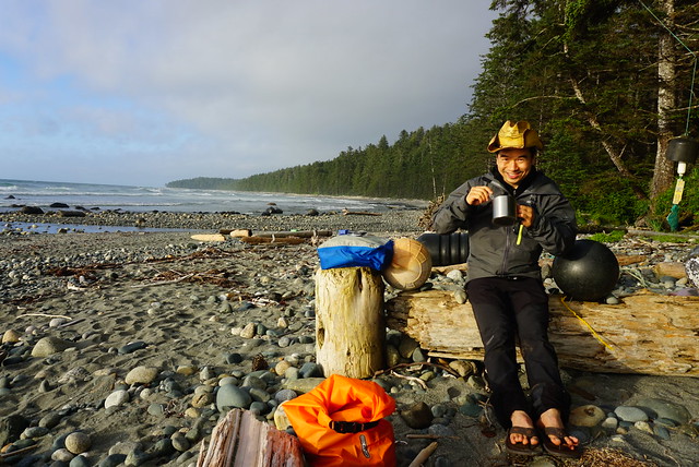
The beach was surprisingly busy for mid-April, but not overly crowded. San Josef Bay consists of two beaches that are only connected at low tide (although there is a forest trail connecting them). The first beach is very large, so there were a steady amount of hikers camped along the back of the beach, but everyone was spread out and it didn’t feel too crowded. I can only imagine how much busier it must be in the summertime. When I visited in June, the parking lot was much busier than in April.
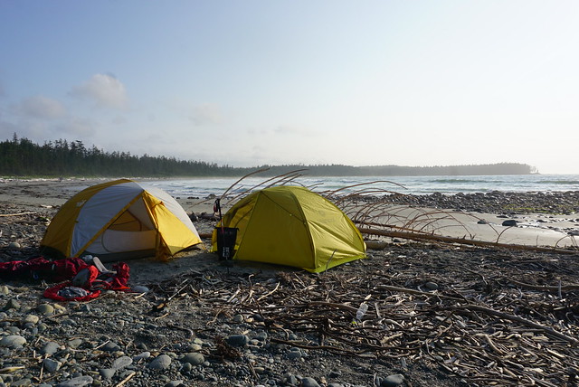
We set up on the main beach because we couldn’t get the wagon to the second beach. Most people were camping on the first beach and after visiting the second beach, I will say that there is much more limited camping space on that one. There’s more log jams at the back of the beach and the water comes closer to the forest at high tide, leaving limited space for tents. High tide is quite a way back from the forest on the first beach, so you can feel pretty safe camping there.


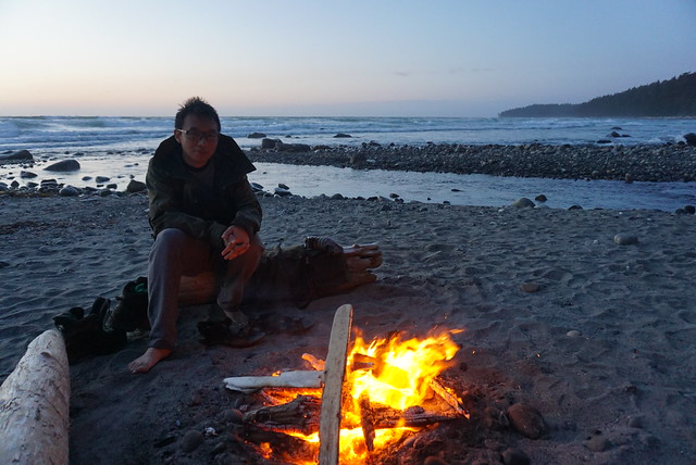
We were pretty late getting set up, so we enjoyed the sunset over the mountains while putting up our tents, and spent the rest of the evening enjoying a fire on the beach. We were able to collect firewood around the beach (never cut down live wood), but dead wood is in limited supply and I imagine it gets much harder to find later in the season. It rained earlier in the afternoon, so I definitely had my work cut out for me getting the fire started!
You never really get to sleep in when you go camping with a dog (they get up with the sun), but Sadie was more reserved than usual and let me sleep until our normal weekday wake-up time at least. It rained overnight, so my first order of business upon waking was to get a tarp set up. I put up one tarp and then Miranda put a second, so we had a nice tarp city ready for when the rain really started!


If you’ve ever been to the north coast of Vancouver Island, you know the weather is super unreliable! The fog loves to hang around the coast and it’s normal for the weather to oscillate between sun, grey, and rain multiple times a day, sometimes within the hour! I didn’t get a lot of rain when I hiked the North Coast Trail, but I didn’t get a lot of sun either. While visiting San Jo Bay in April, we got a little bit of everything all at once. It didn’t rain for any extended periods of time, but there was a pretty reliable cycle switching from rain to sun and back again, all day long.
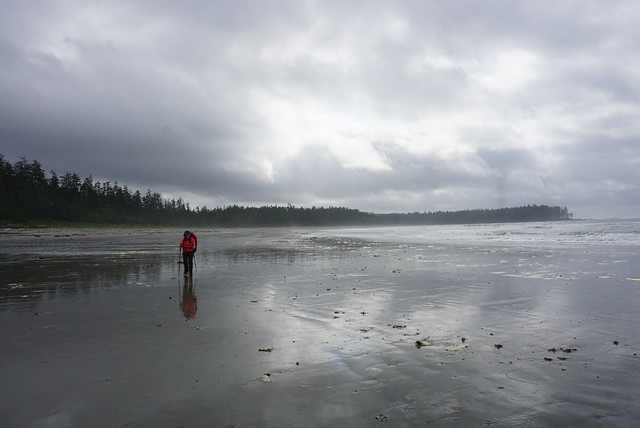
It was dry during breakfast and we got ready to go for a beach walk, but then it started pouring, so we decided to wait it out. Low tide was at noon and the rain let up again around 11:30am, so we quickly got ready to go beachcombing. A lot of day hikers showed up around this time, presumably to explore the tidal areas. There’s a frontcountry rec site close to the parking lot, which I think is popular for campers that want to visit San Jo Bay, but don’t want to backpack.


Exploring the beach during low tide is really the highlight of visiting, so definitely plan your trip around it! When the tide drops, you can walk along the sand to the second beach. The low tide exposes a number of sea stacks and caves along the shoreline and you can walk on several of the islands, looking at sea creatures in the tidepools along the edges. We saw lots of sea anemones, sea stars, and crabs along the tide pools, as well as many other marine organisms that only Seth was able to properly identify. We had a great time exploring and ended up walking the beach for several hours!
Our companions took the wagon to the second beach, where firewood is much more plentiful, and me and Seth went in search of the freshwater source. The main consideration in camping on the first beach is that there’s no fresh water. My Gaia noted a water source on both ends of the second beach, but we opted for the source on the far west side. You do have to hike up into the woods for a few hundred metres and the trail is very muddy, but it’s a reasonably nice source – it’s just a little discoloured from the tannins, which I’m used to from Newfoundland. It was running pretty high because of the rain, so it might not be as nice in the dry season (if such a thing exists in this area).


Overall, it was a pretty low key trip and we mostly relaxed for the rest of the afternoon as the rain continued on and off. The downside of going camping in April is that it was pretty damp and chilly. I spent some time in the tent to warm up, and then later in the afternoon, Seth and I walked down to the opposite end of first beach to the estuary. I’m not sure if you can drink this water when the tide is going out, but based on my experience at other estuaries on the NCT, it’s probably very brackish. Though you could likely drink it if you walked much further upstream.
We had a lot of firewood for night 2, which was good because it rained a lot more. We got the campfire going and kept it pretty big for warmth. It sprinkled on us several times, but it was always short lived, so we never got properly wet. We caught a glimpse of the starts on our first night, but it was completely clouded in on our second night.


The rest of our crew took off pretty early on Sunday morning because they had to drive all the way home. Seth and I had an extra day, so we took our time packing down our tent and were rewarded with a beautiful blue sky view of the beach on the way out. It didn’t last long and was soon raining on us as we trundled through the forest, but the sun made a reappearance near the end of the trail, turning the trees the most beautiful shade of green as the sun peeked through the canopy!
So I finally redeemed myself from my first trip and made it to San Josef Bay! I do think it is worth the hype and would be keen to see what’s it’s like in more reliable weather. But I’m thrilled I can finally check it off my bucket list. Tune in next week to learn what Seth and I did with our last day in the backcountry, because the adventure didn’t end with San Jo Bay!