Flatiron and Needle Peak Backpacking Trip

My scheduled post for this week was supposed to be about Frosty Mountain, a popular Fall hike I did at the end of September. However, the top of the mountain is now under several feet of snow and hiker Jordan Naterer went missing on this trail on October 10, 2020. If you were hiking on the trail on Thanksgiving weekend and saw Jordan, please contact police. If you’re thinking about doing Frosty Mountain yourself, I’d recommend waiting until next year as the season for doing this hike has now passed. In light of this tragedy I’ve decided to postpone that post for another time and write instead about a backpacking trip I went on back in July.

There’s so much exploring to do in the summer, I’m always behind on writing about my adventures, but this summer I had an amazing experience stargazing at Flatiron. I’ve been getting into star photography over the past few years, but Brandon is the real night sky enthusiast of the group. He tries to catch the Perseid meteor shower every year and this year he was really stoked about the Neowise Comet. We decided to make an attempt at stargazing and spent forever trying to come up with a good place to go looking for it. You can’t be too close to the city because there’s so much ambient light, and we wanted to be sure we’d have a good view from our campsite, meaning we needed an unobstructed view looking Northwest. We floated around a few campsites we’d been to before, but nothing was really quite right. Then I remembered Flatiron, which me and Brandon had day hiked in the fall of 2018, and we thought we had a good chance of clear views from the top.

HOP_4875

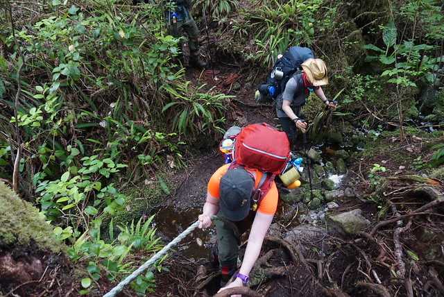
Since we were camping overnight, we didn’t have the earliest start. Flatiron is located in the Coquihalla Summit Rec Area, so it’s a little over 2 hours from my house with no traffic. It was around 1pm when we pulled into the parking lot – we figured we were going to have a hard time parking, but because we arrived later in the day, lots of people were finishing their day hikes, so we managed to snag a spot no problem. We ate lunch in the parking lot and then started hiking sometime around 1:30pm. Our group consisted of our North Coast Trail crew since we’re all in the same bubble and have gotten pretty good at camping together.

Flatiron isn’t the longest trail, only 11km round trip, but it is definitely a steep one. We’d day hiked Mount Cheam the previous week and I’d had a really hard go of it for some reason (just a bad day I guess), but I was feeling pretty good on Flatiron. Lien was having a hard time with all the elevation gain, but we plugged along, taking short, frequent breaks. The more challenging part was the heat. The summer started off slow, but overall, it ended up being a really hot one. I find it’s usually hot in Vancouver throughout the summer, but then I always end up going to the mountains where it’s a lot cooler. This year I found the mountains felt just as hot, so we were really sweating buckets as we climbed up.

DSC06678

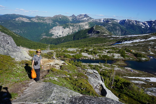
After about an hour you come out of the woods and start hiking up over the rocks towards Needle Peak. Flatiron and Needle Peak are two separate hikes, but they share much of the same trail. Eventually you reach the junction and you can either start the steep ascent up to Needle Peak, or you can continue on to Flatiron. I would say Flatiron is slightly less impressive than Needle Peak, but a much nicer hike, so I’d recommend Flatiron, but many people do both in the same trip. We wanted to do Needle Peak as well since Brandon and I had already done Flatiron once, so we decided we’d make an attempt at it the next day on our way down. There were a lot of people on the trail and we heard that someone had actually gotten married at Needle Peak that day, so it was super crowded at the summit. There were also a lot of backpackers, most of whom were ahead of us on the trail. I usually like to make an earlier start for this reason, but there’s tons of camping space up at Flatiron, so we weren’t worried about it.

HOP_4948

From the junction, the trail continues down and back up to a glacial lake at the foot of Flatiron. Flatiron is so named because it’s basically a mountain with a huge flat top. The lake is located just under the Flatiron and it’s where all of the backpackers were camping. It makes sense seeing as that’s where the water source is, but because we wanted an unimpeded view, we’d decided to camp on top of the Flatiron. From the lake it’s another 20-30 min climb up to the top. It’s not too challenging, but it is steep. When we got to the top, there were lots of day hikers around, but no other campers.

Despite all the space, we did have to walk around for a while to find a good spot for the tent. A lot of the top is just rock, which we could set up on, but obviously isn’t super comfortable, and we were going out of our way to avoid trampling any sensitive areas. There’s a lot of wildflowers up there and we didn’t want to destroy anything. Eventually Brandon found a nice little flat spot that was mostly free of vegetation, so we set the tents up there. We had a perfect view looking west and knew we’d be able to catch both the comet and the sunset from that location.

DSC06682

After setting up the tents and having a snack, we decided to head down to the lake again to get drinking water and have dinner. It was somewhere around 4:30-5ish and me and Emily wanted to go for a swim while the sun was still up above the mountains. We hiked back down and set up on a little peninsula in the middle of the lake. It feels somewhat like two lakes with rivers flowing between them. It’s not the biggest lake, so we were cognizant to make sure we same in the downstream section. Our effort was wasted really as we later saw people swimming upstream as well, so something to keep in mind when you’re in the wilderness. Sometimes, depending on the source, it’s best not to swim at all (if it’s a really small source or there’s no river), in this case we got our water upstream where it was flowing heavier. Overall it’s probably not the end of the world where people were swimming because there were several flowing sections to get your water, but be as considerate as possible.

As expected, the water was absolutely freezing. There was still snow all up along the slope melting into the lake, so we knew it was pretty much all snow melt. We ran into the water as fast as we could and then ran out again, but it felt really good on the muscles! After our quick dip we set into our normal routines, with Brandon and Emily getting drinking water and me and Lien making dinner. Our North Coast Trail trip had been cut short by one evening, so me and Lien both had meals already prepared, so I made a rice dish for me and Emily and Lien made ramen for him and Brandon. The rice dish was a new one for me and it wasn’t my favourite, but it was definitely filling! Then we all had tarts for dessert, which Lien has surprised us with, lugging them all the way up to the top!

HOP_4922

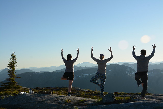
After we’d had our fill, we made our way back up to the top for one of my favourite evenings in the backcountry. Brandon and I get a bit giddy sometimes when we hike together, and we were each making good progress on our flask of fireball, so we decided to have a little dance party up on the mountain. First Emily led us in yoga stretches, and then brandon played music from his speaker while we all danced around waiting for the sun to set. Since the trip was all about stargazing, Brandon and I both lugged up our tripods and set them up for later, with Brandon doing a timelapse on his.

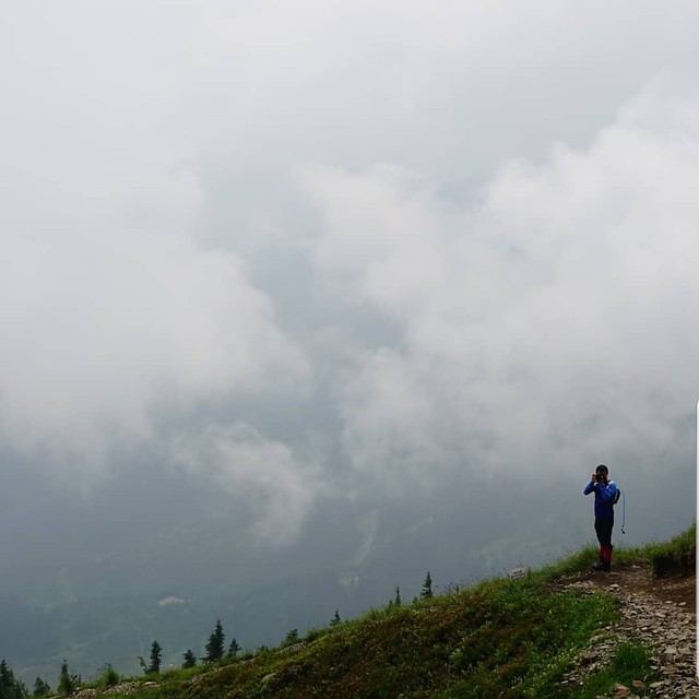
Eventually all the campers from the lake made their way up to the top for sunset as well, but save for one other group of 2, we were the only ones camping at the top. I’m still a bit amazed at how lucky we got with the weather. I feel like it’s easy to plan these idyllic trips, picturing cloudless skies and millions of stars, but they so rarely work out like you intended. But this trip actually did. There were absolutely no clouds and we had a perfect 360 degree from which to watch the sun go down over the mountain and the stars come out.

HOP_4969

The challenging part about stargazing of course is staying up late enough for it. We’d read the best time to see the comet was just after sunset, but we didn’t see any sign of it. However, as it got darker, the milky way became more and more impressive. Brandon and Emily were working on tracking down the comet, but in the meantime, I had a nice little photoshoot with the milky way and got some pictures that I’m pretty proud of. I don’t really know what I’m doing, but the conditions were good for messing around. No ambient light, so the stars were showing up really well. Eventually Emily spotted something moving that she thought might be the comet and her and Brandon spent ages debating whether it was or not. Eventually I came over and was like, ‘well why don’t you shoot it and see how it comes out in the photo…’ to which they were like, ‘oh right, that’s what we came to do lol’. We’re no astrophotographers, but it was obvious from the photo that it was indeed the comet. Photo credit to Brandon for this one:

HOP_5245

The comet is one of those things where skilled photographers have made it look a lot different than it does to the naked eye. We thought we’d be able to see somewhat of a trail behind it with the naked eye, but this is not the case, the trail only shows up on photos, at least from where we were watching anyways. It was still cool to see and Lien and Brandon spent a lot of time photographing the comet. It was definitely harder because it was in the Northwest and so because the sun sets west, it look a lot longer to get dark in that direction. Plus the moon was up and pretty bright, so that made it more challenging to shoot as well. I look a few photos and I’m glad I got to see it, but if I’m being honest, I was a lot more enthralled with the milky way. Saturn and Jupiter were both visible on the evening we were out and I managed to capture both in my photo with the milky way!

DSC06820

Sometime before midnight we gave up and went to bed. Despite how hot it had been in the day, it was pretty cool overnight. Not surprising as we were very exposed and in the mountains. We’d hoped to sleep with the fly off, but it was too dewy, so we popped it back on for the night. Emily had a hard time sleeping and ended up being pretty cold overnight, but I think the rest of us slept okay. Fortunately the sun came up again pretty early and warmed us up. I got to take down a dry tent, which is pretty much one of the best things ever.

We took down camp and set off again, but the day was far from over. Usually we don’t linger too long on the last day, but I was determined to do Needle Peak. The first time I’d hiked Flatiron, we’d actually intended to do Needle Peak, but it was October and there was ice on Needle Peak, so we’d done Flatiron instead. I couldn’t come back twice and not do it, so we planned to drop our bags near the junction and hike up to the top. Lien was feeling pretty tired and decided not to join us, so we did our best to find a shady spot for him and left him with our fly dope. Fortunately it hadn’t been buggy at the top of Flatiron, but it was extremely buggy along the rest of the trail, so I didn’t really envy him hanging out with the mosquitoes.

HOP_5337

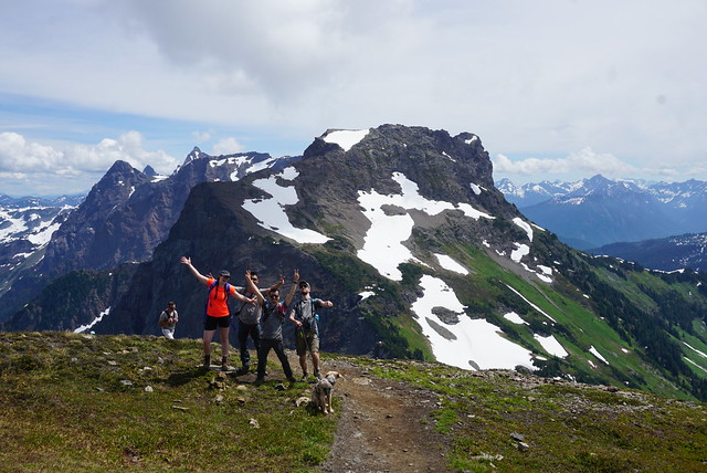
Needle Peak is a challenging hike. It starts off with a steep climb up to the ridgeline. Climb is definitely the best word to describe it and there’s one bottleneck rope section that is particularly challenging. While we were doing that part I was kind of wondering if it was really worth it, but it ended up being one of the most challenging parts and it did get easier after that. I believe it’s only about a kilometre, to the top, so we made pretty good time, but it is somewhat slow going. The ridge has beautiful views looking down both sides and the hike ends with one last scramble up the “needle” part of Needle Peak. We decided not to push all the way to the very top. There were a lot of people and you basically have to climb up this rock seam, so we knew it would take a while because of people bottlenecking at tricky locations. Instead we found a nice rock to sit on while we had lunch and we still had an amazing view looking out over the Coquihalla. One hiker, who we’d been passing back and forth was surprised that we weren’t going to finish the hike, “but you’re so close, you can do it!”, to which I wanted to respond that I knew I can do it, but that I am already satisfied with what I have accomplished this weekend. Sometimes I have a bit of an obsessive personality with wanting to see things through and push farther, but I think this year I’ve been getting better at setting limits. I don’t know if that’s good or bad, it kind of sounds like I’m saying it’s okay not to push myself, but that’s never really been my challenge, so I think learning to set boundaries sometimes is just as important.

HOP_5328

Anyways, we had a good hike and I’m glad I can finally say I did it, but I don’t think I’ll be in a rush to go back to Needle Peak. It’s a tougher hike than I think a lot of people realize and I didn’t feel that safe with so many people on the trail. So we hiked back down, getting bottlenecked again at the rope section. As tough as that section had been on the way up, it was soooo much worse on the way down. We took our time and eventually we were reunited with Lien again.

As usual, the downhill back to the car was a real B for me and Emily. We don’t have the best knees and the last section through the trees is super steep. Plus it was even hotter than the previous day, so again we were all a sweaty mess. Finally we reached the car and I gave my feet and face a nice wash in the river before we headed back into town. So overall it was a really successful trip and probably one of my favourite overnights of the whole summer. The only disclaimer I’ll leave if you’re thinking of doing this trip is that there are no facilities at the top, so come prepared for no outhouse or bear cache facilities. Otherwise, this makes for a great trek!

HOP_4999

Hiking Cheam Peak

One of my favourite local hikes to date is Cheam Peak – which is interesting because the first time I hiked it was in 2018 and in much less than ideal conditions. Cheam Peak is a well known hike in the Fraser Valley, whose sharp peak dominates the skyline as you drive out Highway 1 past Chilliwack. Though you can easily see the mountain from the Highway, you have to enter the trail from the South on Chilliwack Lake Road. I wasn’t expecting it to be a busy hike because you need 4WD to access to the trail head, and it was a pretty smoky day when we hiked it in 2018, so I was shocked when we arrived at the trailhead to find the parking lot packed with trucks and SUVs. As far as 4WD hikes go – I can also assume this is one of the more popular since the mountain peak is so iconic.

5 of us piled into Brandon’s 4Runner to get to the trailhead – a drive that was a lot more fun for Brandon than the rest of us. The higher we drove along the road, the worse the visibility got. 2018 was one of the worst summers for forest fires and the city was filled with smoke for weeks on end, making it hard to do much of anything outdoors without coughing up a lung. The smoke hadn’t peaked yet, but it was also an overcast day and we were high enough to be up in the clouds – so the smoke and fog together made for some really terrible visibility.

The conditions didn’t impact my enjoyment of Mount Cheam though and even with the poor visibility, between the alpine meadows and cute little Spoon Lake, I was in hiking heaven. The meadows start pretty much at the trailhead and are gorgeous and green, with this tiny little swimming hole that looks like it’s been punched out of the landscape. Plus there’s lots of wildflowers if you go at the right time of year. From the meadow, I think you can see up most of the mountain, but unfortunately for us, the meadow was the only part of the trail not shrouded in fog. As we started to ascend, we immediately entered the clouds and lost all sight of anything around us. I’ve hiked a few times in the fog, but this was definitely the worst. The closer we got to the top, the worse it got. It’s not the longest trail, only 9km round trip, but you tackle a lot of elevation gain in that hike, approximately 650m. So it’s pretty steep for most of the hike, with lots of switchbacks and at times I literally couldn’t see my friends if they were more than 6 feet away.

We weaved our way up the mountain until we reached the ridgeline along the top. It was super creepy in the conditions because the fog was getting caught up on the other side of the ridge (towards the highway), so we could see down the ridge a little bit, but the highway side was just a bank of milky white fog. It’s made weirder by the fact that when you reach the top, you get over the mountain sound barrier, so all of sudden you can hear all the traffic from down on the highway. From the peak, Mount Cheam looks down on the highway, but since we were hiking it from the back, we were totally surrounded by the backcountry. Since you can’t see any of the traffic on the way up, you feel like you’re in the middle of the wilderness, it makes for a really weird experience.

20200828_120419

We hung out at the bottom of the ridgeline for a bit and had our lunch. We figured there was no use racing to the top when we couldn’t see anything anyways, so we took our time. The fog did eventually start to thin, so we continued on to the very top, but we never did get a view down into the Fraser Valley. We hung out for a long time taking funny pictures of the fog and messing around, but we eventually gave up on our hope of catching the view and started to head back down again. Despite all the fog and not being able to see the view, I still had a great time on the hike, which I attribute to my companions, who had just as much fun taking photos in the fog as we would have with an amazing view!

The fog continued to thin as we made our way back down again. We could see more of the mountain around us and eventually the fog got high enough that we could see all the way down to the meadow. This was my favourite part of the hike and it made for a nice, scenic walk back. Me and Lien are a bit obsessed with swimming, so we had big plans to take a dip in the little hobbit pond, formally known as Spoon Lake, at the bottom. We didn’t waste any time and both dove right into the water as soon as we got there. It’s a small waterbody and it was the middle of the summer, so it was actually really warm and we had a great time swimming around. From Spoon Lake, it’s just a short walk back out of the meadow and about a kilometre along a gravel road back to the parking lot. So even though the weather conditions weren’t the best, we still had a great time on the hike and will have to keep in on our bucket lists to return on a clearer day!

20200828_120434


Fast forward to 2020. 2 years after our first hike to Mount Cheam, we decided to return and see if we could actually catch the view. It was Sunday morning back in mid July and it was one of the hottest days of the summer. Me and Emily spent all Saturday trying to get into any of the lakes in the lower mainland and were rejected from Buntzen and Sasamat, so we figured cute little Spoon Lake would make for a great end of hike swim the next day.

Even though I never saw the view the first time, I’d loved everything about Mount Cheam, particularly swimming in Spoon Lake, which looks like its been carved out of the hillside. So I was excited to return, this time with Emily, Seth, and Sadie in tow. We drove separately and then all piled into Brandon’s 4×4 for the 9km ride up to the trailhead. I remembered there being some pretty bad waterbars along the forestry road the first time, but I also remembered us driving up it pretty fast. I don’t know if I mis-remembered or if the road has gotten worse, but it seemed in much poorer condition then the last time. It ended up taking us over an hour just to go the 9km! I wasn’t sure how well Sadie would do on the drive. As a puppy she had really bad car sickness, but has mostly grown out of it. Fortunately she seemed to love the 4×4 road! She was running back and forth across me, Seth, and Lien in the back seat to look out the windows as we drove up.

DSC06554

It was a slow year for the snowpack melting, so there was still quite a bit of snow on the trail when we visited in mid-July. Fortunately we had microspikes, but since the snow was so sporadic, it’s a pain constantly taking them on and off, so we mostly went without. Sunglasses are a must with so much snow though – Emily sunburned her eyes crossing the snow fields. Walking into the meadow from the parking lot we could see there was a fair amount of snow left and we were concerned the lake might still be frozen. You can’t see it until you’re pretty much on top of it, so we were anxious as we approached, praying we’d be able to swim in it. Unfortunately, the lake was a real mess. The whole area coming down to the lake looked more or less in shambles. Since our last visit, it looked like there’d been an avalanche in the area. There’s several trees knocked down and a ton of debris coming down into the lake. It looked like there was a bunch of debris from the slide that had been knocked into the lake and was now covered with snow and dirt. We were convinced it would never be swimable again, but I’ve since seen photos of the lake on Instagram later in the summer, and it looks totally fine now, so most of it must have been snow, or the debris suck to the bottom. So we were quite sad at the time, but thrilled to see it more or less seems to have recovered.

DSC06473

The hike ended up being more challenging than I remembered. Like I said above, it’s a short hike, but has a lot of elevation gain. I’m not sure if I was having a bad day or if I’m just out of shape from the pandemic, but it was a challenging hike, even after completing the NCT. I’m inclined to blame it on the heat though because it was well over 30 degrees. From the lake it’s a steady climb for the rest of the hike, the main difference being that this time we got to enjoy the views! A lot of the hike is going back and forth across exposed boulder fields, some of which were still under snow, so caution is definitely advised. On our way down we saw a few people trying to take shortcuts up the boulder field, don’t do this, it’s deceivingly hard, it’s dangerous (loose rock and steeper) and it damages the landscape.

DSC06500

It was a slog, but we reached the top to gorgeous blue sky views of the surrounding area. Looking north you can see Highway 1 all the way out to Harrison Lake, and south is a cacophony of snowy peaked mountains all the way to the States. We sat at the very peak to enjoy our lunch before heading back down again. This was Sadie’s first major hike, so we weren’t sure what to expect, but she LOVED it. She’s definitely an outdoor dog and has a ton of energy. She thrives on steep difficult trails, so she was right in her element on Cheam. Also, she’s obsessed with the snow and loves playing it. I’m not sure if it’s just because it was so hot, but she couldn’t get enough of running around throughout the snow fields. She was totally pooped by the end of the hike though. She was all wet and muddy from running around and we didn’t want her sitting in our laps, so we made her sit on the floor in the back seat and she immediately lay down and fell asleep for most of the car ride back (a feat for Sadie who rarely settles down).

So despite the setbacks with the lake, it was still a great day! It’s a challenge to get to, but well worth the visit, my only recommendation is to leave early to avoid the crowds and go prepared for any condition because you will be a long way from help! Happy hiking everyone!

DSC06586

Cape Scott and North Coast Trail: Part III

The Saga continues – here’s Part 1 and Part 2 if you’re joining in the middle.

On Day 3 we finally started the North Coast Trail. As I mentioned before, most people start with the North Coast Trail and continue on to Cape Scott, but because of some conflicts with the water taxi dates due to Covid-19, we decided to do the trail backwards. So instead of starting with a water taxi from Port Hardy to Shushartie Bay, we had already hiked 37km and we still 43km to go. We hiked from Guise Bay to Nissen Bight before lunch and then continued from Nissen to Laura Creek, our first section on the North Coast Trail.

From the end of Nissen Bight, it’s about 5km in the woods, followed by another kilometre along the beach to reach the campsite. Our feet were already aching from pounding across so many beaches, so it actually felt like a bit of a relief to start climbing up into the woods. There was a noticeable change to the conditions of the trail as soon as we entered the forest. It started with a steep climb up towards Nahwitti Cone and then it was 5km of poorly maintained trail and mud.

DSC06187

The North Coast Trail is a pretty bare bones trail, besides keeping the brush at bay, it seems that the trail is left pretty wild and it makes for a very technical hike. There’s a lot of mud to navigate around as well as tons of obstacles from the trees. You’re constantly climbing up and over logs, under branches, and jumping your way around mud pits. The Juan de Fuca was a similar experience for me and Emily, so we didn’t come across anything unexpected, but we definitely forgot just how challenging and slow these kind of hikes can be.

At first the obstacles were a welcome distraction from our aching feet. When you put your brain to work navigating the obstacles, it does distract from your other pains, but the forest paths make for REALLY slow progress and eventually you just get frustrated at how long it takes to make any kind of progress. This was Lien’s first real challenge. He’d never been on a technical coastal trail before and so he really had no frame of reference for what it would be like. When we first switched our plans from Mount Assiniboine to the North Coast Trail, his first response was, “well at least it will be an easier trail!” We all laughed at him and informed him it would actually be a lot harder, but I can see where the misconception comes in and I have made the same assumption in the past. Mountain trails appear to be harder because of the large elevation gain, but coastal trails often still have a ton of elevation gain hidden among the relentless up and down along the coastline, as well as they’re usually a lot more technical.

HOP_3962

There was a marked difference on Day 3 though in that we barely saw any people. We’d started hiking Cape Scott on the weekend, so it had been crawling with people, but it was now Tuesday and so even on our hike to Nissen Bight we didn’t see many people. After Nissen the trail really emptied out. We saw one hiker just as we were starting the climb to Laura Creek – he was returning from an overnight at Irony Creek (that’s a 19km hike!). After that the only other people we saw was one group of guys who were camping at Nissen and had day hiked out to Laura Creek and back. In mine and Emily’s opinion, it’s a waste of time trying to avoid the mud on a trail like the NCT, so we were both pretty muddy and had wet feet by the end of the day. We had wet feet the entire 4 days we hiked the Juan de Fuca, so in our opinion keeping our feet dry until Day 3 had been a pretty big success. But when we passed the guys coming back from Laura Creek and saw their completely mudless legs and boots, we had to conclude that they were clearly witches to stay so dry.

Lien struggled along this section, mostly from the repetitive uphill sections. I started stronger along the wooded stretch, but eventually it really got to me too. I was tracking the hike along my GPS and every 30-60 minutes I’d check in to see how much progress we were making and it was always a mistake. Your location barely moves and it really only serves to de-motivate you. What was more depressing was that I’d read in the trail book that this was one of the easier wooded sections of the trail, so it made me really apprehensive about what was to come later. So much of making it through these long hikes is mental and often you just have to focus on making it through one part at a time.

DSC06214

Unlike the rest of us though, Day 3 was where Emily peaked. She had a rough Day 2, but she was in her element on this section. Despite her blistered feet, she was our cheerleader for the day and led us through the worst of it. One of the real saving graces of having 4 people in your group is that we didn’t all fall apart at the same time. There was always someone who was struggling, but when that happened, someone else would always step up to help motivate the group. The constant uphill was Lien’s mental block for the day, so we all cheered when we finally started heading downhill in earnest and could see the beach peaking out through the trees. We still had 1 more kilometre to go across the beach, which is it’s own kind of hell at the end of a long day, but at least you make a faster pace.

There was some confusion about where the water source was, so we spent a bit of time poking around for it at the end of the beach, before a closer read revealed that it was actually located right at the campsite. I’d read Laura Creek only had 4 tent pads, so despite seeing no one else on the trail, I was still a little concerned about availability. Me and Emily were anxious to get off our weary feet, so we took off towards the campsite. Fortunately there was only 1 other group of 5 guys at the campsite and they were only using 2 of the tent pads, so there were 2 more left for us.

DSC06213

I have to admit, as relieved as I was to sit down, the tent pads were a little gloomy after the beautiful campsite the previous night. The trees were extremely thick and didn’t let a lot of light in, plus everything felt damp. Fortunately Brandon is much more determined than me or Emily and when he showed up, he dropped off his backpack and declared there was no way we were camping in the woods and he would find us a spot on the beach.

There’s no where to camp on the beach near the tent pads because it’s a steep cobble beach, but if you continue another 200m to the water source, Laura Creek, there’s a small sandy beach with enough room for 3 tents. There was one couple set up there already and they kindly moved their tent to the side so that we could set up our two tents next to them. It was extremely windy, but a definite improvement over the wooded tent pads! So much thanks to Brandon for that!

We put up the tents as fast as we could and chucked all our gear inside to keep them from blowing away. We changed right away because it was cool with the wind in our sweaty clothes. Once I bundled up with a few layers though, I forgot about the wind and was thrilled when the sun finally came out for the first time since we’d started the trail!

DSC06225

The weather on these trails really is wild – it’d been overcast most of the day, but within a half hour the wind completely blew the clouds away and we found ourselves with a gorgeous sunny beach view – so that helped with the chill as well. It was somewhere around 7pm at this point. It ended up taking us about 4 hours to go the 6km from Nissen to Laura, so we knew we were in for some longer days.

By Day 3 we’d started to get into a bit of a routine. Lien got water from the creek to start filtering, Brandon started working on getting a fire going, and me and Emily started boiling water for hot drinks/soup and started making dinner. Emily was the chef for day 3 and served us a cheesy pasta that we’d made from a backpacking website. It was vegan so it used coconut milk powder and nutritional yeast to get the creamy cheesy flavour – it was my first time using either ingredient and it was actually pretty good.

The only downside to our beach campsite was that it was a 200m walk back to the outhouse and bear cache, but definitely still worth it and we ended up having a great night relaxing on the beach by our fire. Laura Creek definitely had the best sunset of the trip; when the clouds cleared out we had an excellent view of the sun as it dipped below the horizon and filled the sky with its orange-yellow glow. We were zonked from the long hike, but relieved that our biggest day was now behind us. Over the next 3 days we’d be averaging about 12km a day, so we were optimistic that though the hiking wouldn’t get easier, the days would at least get shorter. It was an incorrect assumption, but more on that in the next entry, Part IV!

DSC06239