Kayaking Gulf Islands

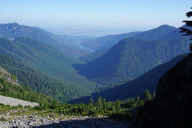
Seth and I have really gotten into kayaking over the past few years and try and go on a 2 night trip once a year. Our first trip was Sechelt Inlet on the Sunshine Coast and the last two years we have been exploring around the Gulf Islands National Park Reserve. It’s a huge reserve, so there’s lots to explore! Last year we spent two nights exploring Pender Island and this year we took the ferry over to Vancouver Island and left from Sidney Marina over the Labour Day weekend.

Some of the larger Gulf Islands campsites are reservable, while the smaller backcountry sites are first come, first serve. I decided to book 2 nights on Sidney Spit, which is about an hour paddle away from Sidney. It has ~30 sites and is only accessible by boat, though most people opt to take the Sidney Spit ferry over to the island rather than paddle there themselves. I wasn’t totally sure what itinerary I wanted to follow, so I booked both nights and then played around with some ideas for where we could explore while we were there. Obviously paddling one hour to the Spit doesn’t make for a super exciting kayak trip, so we wanted to explore some of the other islands.

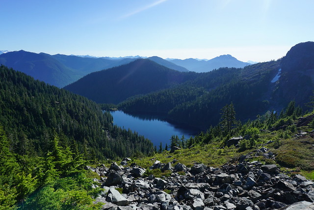
My initial thought was to paddle to D’Arcy Island for the second night. D’Arcy island is about a 10km paddle south from Sidney Spit at the opposite end of the island. However, as it got closer to the kayak trip, it looked like the final day was going to be pretty windy. I didn’t want to risk having a long paddle back in the wind on the final day, so we looked at some other options. It’s a bit far to explore as a day trip (20km), so instead we decided we would spend both nights on Sidney Spit, but day paddle to Rum Island, which is located at the end of a little group of islands on the north side of Sidney Spit, which would be more like 10-12km of paddling.

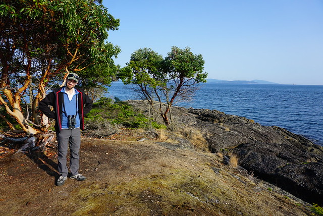
We left Vancouver on the 9am ferry from Tsawassen and went straight to the marina in Sidney. We rented from Blue Dog Kayaks and while we were filling out the paperwork I had a nice chat with one of the staff about where we were planning to paddle, asking about her favourite places. She said that she didn’t really like Sidney Spit because there are a lot of people and boat traffic, and that Rum Island was her favourite place to camp. There’s only 3 sites and because of its location, it’s great for whale watching. We didn’t make any decisions then, but I started toying around with the idea of staying at Rum Island instead. I knew we wanted to be at Sidney Spit for the second night because it would make for the shortest paddle back in the wind on Monday, but there was nothing stopping us from going straight to Rum Island on Saturday.

DSC07755

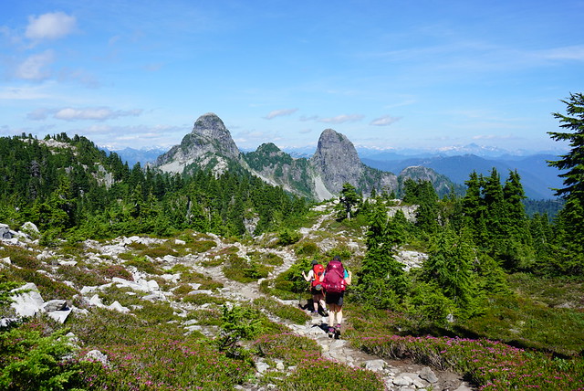
We decided to explore around some of the islands first while we mulled over where to stay for the night. When you leave the marina you can paddle up to the Little Group islands, which is north of the spit. Generally all the islands we wanted to explore kind of circle Sidney Spit, so it gave us time before we had to decide where we wanted to sleep. It was super calm in the marina, but pretty windy once we started paddling up to the islands. Overall I was a bit nervous about this trip because there’s a lot of open water paddling between islands and we didn’t have much experience with that. We stayed close to shore the entire time we were on Pender and while we did cross Sechelt Inlet a few times, it had been a pretty calm day.

It was definitely windier than I liked, but still okay for paddling. It was sometime after noon when we set off, so there was a fair bit of boat traffic zooming back and forth and we did get a bit sloshed around by the wake. Seth had trouble with steering in the waves since he never uses a rudder, and while I didn’t have trouble steering, my kayak seat wasn’t super well designed and I found it hard to get comfortable so that I could engage all the right muscles for paddling. Eventually we figured it out and made it work, but they weren’t my favourite kayaks. I still say Pender Island kayaks have the best rentals I’ve seen to date.

DSC07798

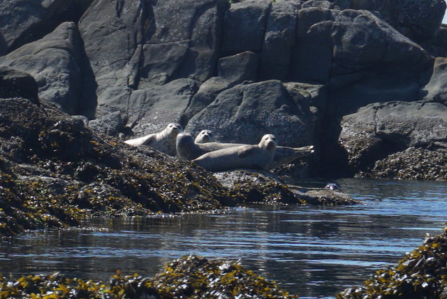
Anyways, it was a lot of work paddling, so we stopped at the biggest island in the Little Group and had lunch. I admitted that I was feeling drawn to the idea of camping at Rum Island that night instead, but was concerned about the long paddle to get there. We decided to set out towards Forrest Island, which is closest to the end of Sidney Spit, and then make a decision. We saw some seals lounging around the rest of the Little Group islands and made the crossing over to Forrest Island. We were definitely feeling the burn of the wind and not having kayaked in a while, so we mulled over what was the best decision. I was curious about Rum Island because I knew Sidney Spit was going to be very busy and I thought it might be nice to have a quieter night. But with only 3 campsites on the island and it already being 2pm, I was concerned we wouldn’t find somewhere to camp and I definitely didn’t have the energy to kayak all the way back to Sidney Spit after. Seth was more into going to Sidney Spit because he didn’t want to have to put up and take down camp twice, plus his logic was that we could still visit Rum Island as a day trip.

DSC07778

We agreed it was probably better to head to Sidney Spit, but as soon as we pushed back off the beach I started doubting myself again and even though Seth wanted to go to Sidney Spit, he made the call that we would push for Rum Island. He could tell I wanted to go and said that we were more likely to regret not going, so lets just do it. Aside from one other couple we’d seen at Little Group, there were no other kayakers around, so he reasoned it was likely there would be space for us.

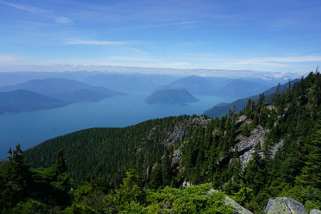
It was a longer paddle than going to Sidney Spit. We had to do a water crossing over to Domville Island and then again to Gooch Island. We did it in one go and then took a break at a beach on the end of Gooch Island. Now that we’d committed, I felt much more sure of my decision and was excited see what Rum Island was like. We’d paddled up the south side of Domville Island, which was one of the hardest sections because a strong headwind funneled down toward us, but it was much more calm when we switched to the north side of Gooch Island. Seth spotted some cool ducks along the way and finally we landed on Rum Island. It’s not really a true island as it’s attached to Gooch, so we beached our kayaks between the two.

DSC07767

Fortunately for us, there were only two other tents at Rum Island and we happily took the 3rd site. No one else showed up, so it was a pretty ideal evening and we only had to share the island with 3 other people. I do love the Gulf Islands, especially all the arbutus trees. We were surrounded by them at our little campsite and had a great view looking out into the strait. I also love that all the National Park campsites have picnic tables for each site, a real novelty in the backcountry! These remote sites are not monitored full time by Parks Canada, but there were 2 outhouses with toilet paper and hand sanitizer, and there’s a self registration box to pay your $10 camp fee when you arrive. There’s no predators on the Gulf Islands, so there’s no bear cache.

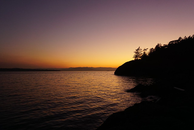
The one downside was that the wind was blowing right into our campsite, so while we’d been warm on the water, it was pretty chilly at camp. We decided to go for a little walk around the island to explore. It’s not very big, but you get beautiful views of the water and the little lighthouse at the end of the island. Otherwise, we took it pretty easy for the night. It’s easier to bring more luxuries when kayak camping, so we each had a little camp chair, which we set up to enjoy the view with a cold beer from our small cooler. We had chili for dinner and spent the rest of the evening watching the sun set over the rocks. We didn’t see any whales, but it was still a gorgeous evening. Once the sun went down, we went to bed early, having one of the best night’s sleep in tent, sleeping for almost 11 hours!

DSC07826

We got up around 8am, but I happened to wake up right at sunrise for a pee break and caught a beautiful glimpse of the sun coming up over the strait. The water was dead calm in the morning and we were excited to start paddling. Everyone got up and departed around the same time because I think we were all anxious to take advantage of the easy paddling after how windy it was on Saturday. My experience over the years has generally been that morning and evening are the best times for paddling. The wind tends to come up in the middle of the day, so I prefer to get up early on kayak trips.

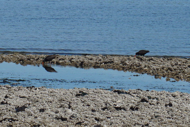
We decided to head back towards Sidney Spit on the south side of Gooch Island this time and we paddled around Rum Island to check out the lighthouse, spotting some oystercatchers hanging out on the rocks. Seth did his Masters thesis on oystercatchers, so we love seeing them in the wild. They’re pretty hilarious with their giant carrot-looking bills and they made this adorable squeaking sound. I have a bit of a love hate relationship with kayaking because paddling in the wind is so exhausting, but there’s really nothing more enjoyable then drifting along on a really calm day. We took our time heading down Gooch Island and saw both a mink and a deer around the edge of the island. We also saw some dolphins swimming along in the Strait, though sadly no whales. We did catch a glimpse of a whale while having breakfast, but it never breached the surface, so we couldn’t tell what kind of whale it was, only see its wake as it swam along.

DSC07840

It was a much easier paddle back to Domville Island this time and we spent some time exploring the end of the island. There’s a little island called Ruby Island and lots of rocky shelves that were completely covered in seals. We always try to keep our distance with seals, but they always seem to get spooked anyways and drop into the water. One tip is to always approach them from the side and never head on as this makes them nervous, but even doing this, they usually prefer to observe us from the water. We took a break at the end of Domville Island this time and in the interest of switching things up from the previous day, decided to skip paddling up the island again and instead crossed over to the south side of Forrest Island. There’s a bunch of rocks at the end of the island that we thought looked promising. As a kayaker, you learn to always check out the little rock clusters because you’re almost always guaranteed to find wildlife there. Again, we found tons of seals and some cute little terns and a bunch of cormorants hanging around. We followed Forrest Island along the south until we were across from the tip of Sidney Spit and then made our last open water crossing for the day.

DSC07850

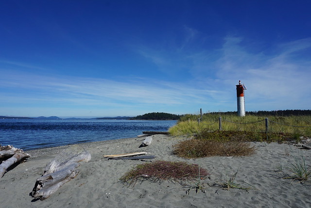
Even after the many open water crossings of this trip, I’m still not really a fan. It was so much easier on the second day, but overall it’s a lot less fun than paddling along the islands. Sidney Spit is definitely an interesting place. I could see why frequent paddlers in the area wouldn’t love it, but I’m glad we had the opportunity to experience both Sidney Spit and Rum Island as they feel like they are worlds apart from one another. Google maps doesn’t show the full Spit as parts of it are underwater when the tide comes up, but when the tide is low, you can walk several kilometers along the spit from the main island to the lighthouse at the end. It was low tide when we landed on the end of the Spit. The inside curve of the spit is super popular among sailboats and yachts and there were tons of people enjoying a day an the beach. There was no one at the end of the spit or down the other side, so we decided to hang out there for a bit and have lunch.

DSC07892

Even though there was little wind, it was very choppy at the end of the Spit where the water meets from both sides. It was a bit of struggle to push the kayaks back out into it, but only took a minute to paddle back to the relative calm of the inner part of the spit. We continued kayaking up the Spit, stopping again to check out some tidepools and counted 25+ oystercatchers hanging out and scavenging along the low tide. The wind had started to pick up, but once we reached the lagoon part of the island, it was dead calm again and we paddled into the beach next to our campsite.

I’d only made the reservation about 2 weeks prior, so I couldn’t really believe my luck in getting what I would consider prime camp spots. Like I said, most people come in on the passenger ferry, which is about a kilometer away from the campground, so they have to hike their gear in, but we had campsite number 1, which is located right next to the beach, so we were able to just pull up on the beach and unload right to our campsite. Besides us, there was only one other site that had kayaked in. It was a family of 4 and they happened to be right next to us.

DSC07880

It was still pretty early in the afternoon when we arrived, but unlike Rum Island, it was really hot. The lagoon shelters the campsite, so there’s very little airflow coming in and the sun just beats down on you. We set up camp and then hung out in the shade for a bit. We didn’t want to let the afternoon slip by, so we decided to go on a little hike along the lagoon trail. After having completed this hike, I have to say “lagoon trail” is a bit of a misnomer. It does track around the edge of the lagoon, popping out on the beach on the west side of the island, but there are approximately zero lagoon views. Seth pushed his way through the shrubs to catch a glimpse, but mostly it’s just forested. It wasn’t too disappointing though because the beach on this side of the island is pretty much deserted. All the crowds hang out along the spit, so we had a nice walk along the sandy beach to pass the time.

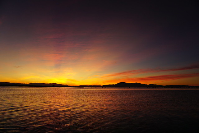
I wish we could have gone swimming, but the timing wasn’t really right. It was right at low tide when we arrived and the lagoon gets pretty gross at that point. It’s all shallow stagnant water with marshy grass. However, when the tide comes up, it cleans out the lagoon debris and moves up over the sandy beach, making for great swimming – it was just too late in the evening at that point to want to go for a dip. Instead, we decided to take the kayaks out for a short sunset paddle. We paddled across the lagoon to watch it set behind the horizon, and then headed back to the campsite as the light disappeared. This was just before the smoke from the US fires started to move into BC, so it was an amazing orange sky!

DSC07974

The one thing that hung over us for the entirety of the trip was our Monday morning paddle. I was keeping a close eye on the weather and Sidney had actually issued a wind warning for Monday, with winds gusting up to 70km/h. 20km/h is generally acknowledged as the threshold for kayakers, so I was keen to get out of there as fast as possible in the morning since we had to do a 3km open water paddle. It was still calling for wind early in the morning, but my experience has been that its usually pretty calm if you go early enough. We decided we would get up at 5am, aiming to be on the water by 7am.

It was pitch dark when we got up. There was definitely some wind, but it looked manageable. The trickiest part is that in the lagoon, it’s usually calm and it’s not until you paddle further out that you get an idea of what the weather is actually like. It started to brighten up shortly after 6am and by 6:30am, we were pushing back from the beach to start our paddle. I love paddling early in the morning, but it’s definitely the first time I’ve been on the water before sunrise.

DSC07926

It was a bit of a struggle to paddle up out of the lagoon. We followed the sandbar to the edge of the spit and although it wasn’t very wavy, we did have a pretty strong headwind to push against on our way out. It wasn’t too strong that we couldn’t push through it, but strong enough to give us an early morning workout. According to Seth though I was super speedy, which tends to happen when I’m anxious about something and my adrenaline kicks in.

We stopped for a break at the end of the spit to prepare ourselves for the paddle across to Sidney. Our plan was to assess the crossing from the end of the Spit and we had come prepared for the event that we wouldn’t be able to make it (brought enough food and water for an extra night), but fortunately it wasn’t looking bad yet and we were optimistic it might be a bit easier than paddling out of the spit since we’d no longer be paddling into a headwind. We were right. It was a bit choppy pushing off the spit, but the water was pretty calm going across the strait. It was certainly easier than it had been when we’d started paddling on Saturday and we had the advantage of being ahead of all the other boat traffic, so there was no wake on the water. It ended up being one of our nicer open water paddles. We took our time to avoid tiring ourselves out in the event the wind did pick up, but we ended up doing the crossing in about 45 minutes and pulled into the wharf in Sidney at 8am.

DSC07914

Since it was still early in the day, we decided to stick around Sidney for a bit. We had a nice second breakfast at an outdoor patio on the main street and then did a bit of shopping. I had no idea that Sidney is also known as “booktown” and has a ton of bookstores lining the main street! So we ended up visiting two shops and I went home with my bag a little heavier and my wallet a little lighter. We had a 4pm ferry reservation, but we didn’t want to wait that long, so we tried to catch the 12pm instead. It was super busy at the ferry terminal with all the long weekend traffic, so we did not make the 12pm ferry, but we did get the 1pm and were happy to have a few more hours to relax at home!

So overall, it ended up being another great kayaking trip! I probably wouldn’t rank it as my favourite because of all the open water paddling, but I’m glad we decided to stay at two different campsites and I had a lot of fun adventuring around the area. There’s still a lot more campsites and islands to explore in the Gulf Islands, so we’ll definitely be back!

DSC07756

Howe Sound Crest Trail: Part II

Though we went to bed pretty early on Day 1, we didn’t get the best night’s sleep. It was definitely not cold, but Emily woke up with heartburn in the middle of the night and had to go for a little midnight stroll to ward it off. Then she proceeded to read her book in the middle of the tent with the light on, so I went and made some unsuccessful attempts at star photography. All while Carolyn slept on oblivious. She doesn’t usually sleep very well, so we were all surprised by this, but she’s also generally pretty cold at night, so maybe it had something to do with actually being warm for once. Either way, when me and Emily finally drifted off to sleep in the early morning, Carolyn was awake and ready to go at 5:45am. Yay.

DSC07616

It was a pretty dismal breakfast. While we weren’t running super low on water, we were definitely conserving, so we boiled the bare minimum for our oatmeal and then packed up camp for the day. On the plus side, it was another gorgeous day and it was already hot enough for shorts at 8am, so it was probably a good idea to get an earlier start. We departed the campsite at 8:30am with somewhere between 1-1.5L of water each and 3.5km to go to the first water source.

Unfortunately, it was some of the hardest 3.5km. Between the Lions and Magnesia Meadows, the trail follows peak after peak after peak. It was gorgeous and breath-taking, but a little stressful when you’re sweating buckets, thirsty, and running low on water. If it hadn’t been so hot, I think our water would have gone a lot further and we would have been a lot less tired, but there’s very little shade along the trail and it’s still very technical, so it makes for a slow go. I had sussed out the topography before we left camp and we could pretty much see our end goal when we started, but it didn’t make the morning go any faster. The hours dragged on as we lugged our packs up and down peak after peak. Carolyn was feeling strong, but me and Emily were definitely struggling, mostly I think because of our anxiety about the water situation, but the heat certainly didn’t help.

DSC07622

Finally, we started the last climb up the pass to Magnesia Meadows. We could see Mount Harvey looming over the meadow and we were just hoping the water source wasn’t located very far off the trail. We’d intended to summit Mount Harvey since we only had about 10km of hiking to do that day, but after 3.5km took us 3.5 hours of hiking, water was our main priority. We could see the red roof of the emergency hut as we crested the slope and from there we all but ran to the water source, relieved to see a small, but pretty clean water hole off the side of the trail.

We all finished off the dregs of our platypuses and then set to filtering enough water for the rest of the day. Since it was now noon and we were all in need of a break, we decided to have lunch in the meadow and made the pretty much unanimous decision to skip Mount Harvey. It was a little bit of a bummer to skip it, because we were so close to it, but it also looked really steep and we were all tired, so it’s important to know your limits. Plus you know, it’s always worth leaving something to come back for.

DSC07646

The hiking improved a lot after lunch. It wasn’t as scenic as the morning, but the trail was a lot easier and mostly hiked around the bowl of Magnesia Meadow. We were thrilled to discover there were still some wildflowers in bloom and had a pretty nice hike up to the branch for Brunswick Mountain. Again, we had planned to summit Brunswick Mountain, but we decided that, given the heat, we’d rather spend our time swimming in Brunswick Lake than hiking up another mountain. So Brunswick Mountain will also have to wait for another day.

I don’t regret the decision though. We ended up arriving at Brunswick Lake around 3pm and we were all zonked. We hadn’t decided in advance exactly where we were going to camp, but we’d originally been thinking Deeks Lake, which was a few kilometres further along the trail, but we’d heard from many people that Brunswick Lake was nicer. We could see the beautiful blue hues of the lake poking through the trees and as we exited the woods next to the lake, I truly could believe we were in a tropical paradise. The water was so clear and blue and looking super inviting. We knew it was freezing of course, but it still looked inviting.

DSC07712

So we decided to stay there. We dropped our bags in an empty clearing and made a beeline straight for the water. As expected, it was cold, but honestly we were expecting it to be worse, so we were pleasantly surprised. We didn’t want to stay in the water too long, but it wasn’t the run-in-and-out-as-fast-as-you-can kind of cold… if you know what I mean.

The rest of the afternoon was lovely and lazy. We lounged in the sun and did a whole lot of nothing. There was definitely a lot more traffic at Brunswick Lake, especially since it was a Saturday. There were probably 4 or 5 tents when we showed up and more backpackers kept showing up throughout the day, all the way until 9pm. The last people that I was aware of were 2 girls who had hiked all the way from Cypress that morning. They said they’d been hiking for 12 hours, which I admire, but definitely don’t envy.

DSC07692

Carolyn made us chili for dinner and we enjoyed watching the sun go down over the mountains. Even though there were tons of people at the lake, we were some of the only ones who hung out on the beach into the evening. It was pretty buggy and most people were taking refuge from the mosquitoes in their tents. As beautiful as Brunswick Lake is, the real downside to the Howe Sound Crest Trail is that there are no outhouses anywhere on the trail. I’m fine with peeing in the woods and digging catholes, but there were a lot of people camping at Brunswick Lake and there are few private places to use the washroom. With so many people, I do think it’s time for BC Parks to invest in an outhouse at each of the campsites, if only to protect the landscape. Check out my recent post on Backcountry Bathrooms if you looking for some tips for when there are no facilities.

It was another warm night in the tent and I think we all slept better on the second night and actually slept in until almost 8am the next morning. We took our time with breakfast, so it was a bit of a later start, but it was nice and chill. It’s about an hour hike to Deeks Lake, passing by Hanover Lake and some beautiful waterfalls. We were pretty much done with the views for the trek, but it was nice to hike in the shade of the forest for a change. Deeks Lake is bigger than Brunswick Lake and also very beautiful, but there’s not very many campsites and they’re all in the trees, so I definitely don’t regret staying at Brunswick Lake – in my opinion it’s the better of the two lakes.

DSC07744

We decided to finish off the trek with a swim in Deeks Lake. It was also very cold, but we thought it was slightly less cold than Brunswick and stayed in the water for a while. After that it was ~8-9km hike down to the parking lot. There’s not a lot to see along the trail and you undo a lot of elevation gain. In total we did about 1500 metres in elevation gain over the entire trail, but we also had almost 2400 metres in elevation loss, half of which was on the last day, so it was mostly a climb down on Day 3. It’s pretty steep for the first section after you leave Deeks Lake, but it eventually levels out a bit into a steady downhill. The last section of trail is outside of the park and mostly along old forestry roads. The very end of the trail now has a detour because of mining work happening on private land at the end of the trail. We were pretty fast coming down the trail, but I could see it being a bit of a slog if you were hiking the other direction. Though there were a lot of people at the Lake, I think the majority of them had hiked up from Porteau Cove. A handful of us had done the whole trail from Cypress, but I think we were the minority.

And that concludes our adventure on the Howe Sound Crest Trail! We didn’t summit any of the mountains we’d planned to summit, but we did still climb a lot of peaks and saw a lot of amazing views. I would do it differently in future (mostly with the water), but I wouldn’t be deterred from coming back. I think if I was to return, I’d maybe hike up from the Mount Harvey or Brunswick trailheads and camp either in the meadows or at the Lake. There’s lots of different ways to customize the trip and still lots left to explore on the trail!


Howe Sound Crest Trail: Part I

I finally hiked the Howe Sound Crest Trail!

Seriously, I’ve been trying to hike this trail since 2017. We couldn’t do it as planned in 2017 because there was too much snow on the trail, in 2018 it was too smoky, and in 2019 there was an issue with re-routing the trail. But the stars finally aligned and I hiked it in mid August with Carolyn and Emily. It was not at all what I expected – I knew it would be a tough trail, but the topography was so much more challenging than I anticipated. That said, we had amazing weather for it and still had a great time!

DSC07480

The Howe Sound Crest Trail is a 29km trail that runs from Cypress Mountain to Porteau Cove. It passes by several iconic peaks and is popular among trail runners. The window for hiking the trail is short, which is why we had so much trouble with it – there’s generally still snow up there in June, which is very dangerous because of snow bridges and snow wells. But what makes the hike so challenging is water access. Once you leave Cypress, there’s no water access for 14km, so you either have to bring a lot of water with you, or hike the most challenging part of the trail in a single day. 14km doesn’t really sound like that much, but there’s a lot of elevation gain and it involves crossing many challenging peaks. It can definitely be done, but I think it would make the trail less enjoyable as there’d be less time to appreciate the views. Plus the most challenging part of the 14km is the last 4km, so it’s easy to think you’re making a good pace and then get hung up at the end.

So long story short, we opted to bring extra water. I think this was definitely the right choice for us, but it was a 30 degree weekend and we drank more than we thought and ended up having to conserve at the end, so in future I would bring even more. But let’s start at the beginning. Because we were planning to do the trail over 3 days, we took Friday off work to get a head start on the trail. Generally there is no pass needed to hike the HSCT, but BC Parks has the new day pass system, so I got up at 6am to get passes for us. I managed to snag 3 passes, but they sold out by 6:01am, so you definitely have to be on the ball.

DSC07503

We arrived at Cypress around 9am and there were a ton of people hanging out in the parking lot. The first stop on the HSCT is St. Mark’s Summit, which is super popular among day hikers, so we think that’s who was taking up most of the day passes. After St. Mark’s the traffic on the trail was drastically reduced. Seth dropped us off and I believe we started hiking sometime around 9:30am. I figured this would give us lots of time, but it was still almost 6pm by the time we rolled into our campsite at the 11km mark, so definitely give yourself lots of time.

Thanks to the early start we were able to hike at a pretty leisurely pace. It didn’t take long at all to get to St. Mark’s, mostly I think because me and Carolyn hadn’t seen each other in a while and we were gabbing the whole way there. We stopped at St. Mark’s for a snack break and then got lost trying to get back on the trail. Overall the trail isn’t too hard to follow, but there were definitely several sections where we ended up off course, so I was glad me and Carolyn both had GPS as we used it more than once to find the trail.

DSC07499

The second stop on the trail is Unnecessary Mountain – I found this one a little confusing because there were two unnecessary mountains showing up on my GPS, the first of which was marked South. We were getting pretty hungry for lunch, so we stopped to eat when we hit the ridge, before reaching Unnecessary Mountains. Like I said, it was a hot day. We thought it would be cooler up in the mountains, but most of the trail is exposed, so it was definitely hot the whole weekend. I had a large iced tea before starting the trail to hydrate, but Emily forgot and was pretty dehydrated starting out, so she drank her water a lot faster.

The view of Howe Sound and the Lions from Unnecessary Mountain is gorgeous, but after that the trail gets a lot harder. It’s a pretty technical trail, with lots of rope sections, climbing, and steep ascents and descents. It’s a through trail (rather than a loop), so you can hike from either direction, but almost everyone goes from Cypress to Porteau Cove because you’re basically hiking from Cypress Mountain down to the highway and people want to avoid all the elevation gain.

DSC07506

It may be challenging, but the section of trail leading up and past the Lions is one of the most beautiful parts of the trail. We hiked along the ridge up towards the West Lion. It was a bit of a climb, so we continued to drink lots of water with the sun bearing down on us. You can summit the West Lion along the trail – we hadn’t decided whether we were going to attempt it or not – but once we got a look at it, me and Emily were firmly in the ‘no’ category. Carolyn is much more intrepid than us and I know she would have hiked it in a heartbeat, but it was now after 4pm and the trail started with two steep rope sections, so we all agreed it wasn’t really a wise choice.

Instead we had a break under the West Lion and then started the descent down and around it. For those not familiar with the Lions, they are two iconic mountains located just outside Vancouver. The familiar looking humps can easily be seen from the city and have become a bit of a symbol of Vancouver. I’ve seen them tons of times, from the city, from other trails, and even from helicopter, but I’ve definitely never been so close to them – it felt a little unreal. Both Lions are incredibly steep, I’m not sure if you can physically hike the East Lion or not, but either way, you’re not allowed to because it’s located in the watershed. Metro Vancouver has one of the best protected watersheds and absolutely no recreation is permitted inside it. The HSCT skirts right along the watershed and the trail unbelievably enough, goes right between the two Lions.

DSC07541

Between the two lions there is another smaller peak called Thomas’ Peak. The scariest section of the trail was definitely traversing down the side of the West Lion to Thomas Peak. You go down a steep section, which isn’t too bad, but then you have to navigate a small ledge around the edge of the Lion and up to Thomas Peak. It’s not terrifying, but you definitely proceed with caution. From there though there’s an amazing view down into the watershed and Capilano Lake. Some of the best city views of the Lions are from Cap Lake, so the same can be said when you’re looking back the other way too.

As we went over Thomas Peak, we were starting to get pretty done with hiking. There’s 3 official campsites on the trail, and one unofficial, which is the one we were aiming for. I couldn’t find its location on any maps and had just seen it listed as “the ridge above Enchantment Lake”. I knew it was located around 11km, so we were planning to just look for anywhere good to camp along the trail once we passed the Lions (which are located around 10km). From Thomas Peak, you can see the trail as it winds over peak after peak, but we couldn’t really see anywhere that looked great to pitch a tent.

DSC07545

As we started to come down, I noticed a ridge branching off the main trail that looked promising. Fortunately, it wasn’t too far away (less than a km, as we’ve established) and when we reached the branch, it quickly became evident this was the place. We were just confused because we assumed “the ridge” was on the trail, but it’s just off to the right of the trail as you come down Thomas Peak. There’s no easily accessible water source from the trail, but there are some flat spots to pitch a tent. If you’re desperate, you can hike down to Enchantment Lake, but it’s a bit of a trek. There’s also a small pond on the other side, but it’s located in the watershed, so this should not be part of your plan.

We had to do a bit of water assessment after we set up our tent. Emily had drained her 2 litre platypus around the West Lion, but me and Carolyn were still on our initial supply. We had each brought 4litres. It was enough, but only because we put a lot of effort into conserving towards the end. My logic had been 2L for the first day, 1L for overnight, and 1L for the 3km the next day. We had brought sandwiches for lunch to avoid needing water for cooking, but had forgotten to take into account water for our oatmeal (only 150ml a person, so not the end of the world), but we hadn’t taken enough for how hot it was. Also, the 3km the following day was SUPER challenging and ended up taking us 3 hours, so we really could have used more water for that as well. It’s not a great feeling having to conserve water, so if I did it again I would bring 5-6L. We might have had a different experience on a cool day, but always plan for the worst.

DSC07562

Our campsite was amazing though! We shared it with one other group of 2 women, who we’d been passing back and forth on the trail all day. We were located right under the Lions and it was dreamy to watch the sun set over the Sound and then watch the stars come out around the Lions. I thought there would be too much ambient light for stars, but the stargazing was actually great – though there was still too much ambient light for star photography (at least for a notice like me). So overall, it was a challenging, but fun first day on the trail and we were thrilled with the location of our campsite! You definitely need nice weather to hike this trail though, I can only image how slippery and dangerous it would be in the rain – plus camping would be very exposed in any adverse conditions. But luckily for us, all we had to worry about was heat management.

I’ll end the post there for now – check back in for my next post on the second half of the trail!

DSC07571