Wells Gray Park Waterfall Guide

After a fantastic day hiking to see the wildflowers in Trophy Meadows, I spent 2 nights camping at Clearwater Lake Campsite in Wells Gray Provincial Park. As discussed in my previous post, Wells Gray is a popular park, both among locals and tourists. It’s particularly well known for its many waterfalls, as well as its paddling. The goal for our second day in the park was to see as many waterfalls as possible. Some of the waterfalls in the park are easily accessible from viewpoints off the main road, while others require hiking to visit. 

Below I’ve compiled a list of all the waterfalls we visited, as well as a few other notable waterfalls. We only had one day to see as many waterfalls as possible, so you can see a lot of waterfalls in a single day trip. It’s ~1 hour to drive from Clearwater town to Clearwater Lake, which can be spread out across the day. Even though we started our trip from Clearwater Lake, I’m going to start this list from Clearwater Town, outlining all the stops you can make as you drive further into the park. That way, if you only have one day, you can turn around at any point. 

Triple Decker and Candle Creek Falls

These two waterfalls are not actually located in Wells Gray, but they’re along the main road and only 5km from Clearwater town, so they’re easy to visit. Triple Decker Falls is located right off the highway and is ~1km round trip to hike down to the viewpoint. Candle Creek Falls is located 2km down the Candle Creek trail, so it does involve a bit more hiking to see this waterfall (4km round trip). I didn’t actually visit either of these waterfalls, but I included them due to their proximity to town!

Spahats Creek Falls

PSX_20250821_084021

Spahats Creek Falls is located at the south end of Wells Gray Park, only 10km from Clearwater town. It’s one of the more popular waterfalls in the Park and very easy to visit. There’s a large parking lot with bathroom facilities and a very well developed viewing platform that allows you to see the waterfall both from alongside it, and from across the canyon (the better view). I’m pretty sure the viewing platform is wheelchair accessible. Over time, the raging waterfall has greatly eroded the canyon walls and the waterfall now plunges 60m down through the valley. I did like this waterfall, but it’s very similar to the iconic Helmcken Falls – so given the choice, prioritize that one instead.

Silvertip Falls

This is one of the more challenging waterfalls to visit because the road access is very poor. The trailhead should always be accessible by 4×4, high clearance vehicles, otherwise, check about the condition of the road at the visitor centre. To access, you drive down Spahats Creek FSR, which is located just past Spahats Creek Falls. The trailhead is located at Silvertip Falls Rec Site. It’s a 500m walk to the viewpoint, but it is all uphill. This is one of the tallest waterfalls in the park, but it’s not a continuous waterfall, it cascades down along the mountainside, so the trail can be quite wet. I haven’t actually visited this waterfall, but it is one of the notable ones in the park.
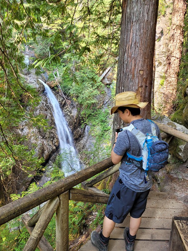
Moul Falls

PSX_20250911_083842

This is my personal favourite waterfall in the park. It is one of the longer hikes on this list to access the falls, but the reward is well worth it! The trail is located just off the main road, 20km from Clearwater town. It’s ~6km round trip to visit the waterfall, but it’s a fairly easy trail through the forest until you get to the waterfall. There’s a viewing platform at the top of Moul Falls, but the real treat is walking down a large set of stairs to get to the base of the waterfall. From there, you can actually follow a non-official trail that goes behind the waterfall to the other side of the pool. There is definitely risk associated with this since the spray of the falls leaves the trail very wet, so exercise caution. Otherwise, it’s such a cool experience!

Dawson Falls

PSX_20250821_083715

Dawson Falls is another fun waterfall. It’s not as memorable as Moul Falls or Helmcken Falls, as it feels like more of an extension of the Murtle River, but I still thought it was really beautiful. Park at the Dawson Falls parking lot, located 40km from Clearwater town, and then walk ~500m along an easy, flat trail to see the waterfall. There’s a preliminary viewpoint, followed by a viewing platform on top of the falls. If you follow some of the small trails along the edge of the platform, you can walk down to river level to look up at the falls. I liked this one because it’s really a series of stepped waterfalls and I thought it was unique. Plus it’s quick to visit, so definitely worth it!

Mushbowl

The Mushbowl is less of a waterfall and more of a water feature. It’s located just past Dawson Falls and can be viewed as you cross the bridge over the Murtle River. There’s no viewpoint for this one, so just drive slow and enjoy the view of the raging rapids from the car!
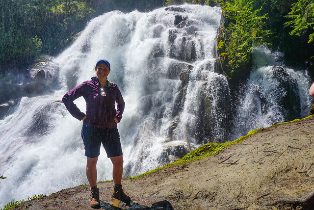
Helmcken Falls

PSX_20250821_083633

Without a doubt, Helmcken Falls is the most popular waterfall in the park. It’s very well marketed by the province and it gets a lot of visitors every year. It’s the 4th tallest waterfall in BC and is often featured on “most beautiful waterfalls in Canada” lists. It’s a striking waterfall that cascades over the edge of an eroded canyon to the valley below. There’s a huge viewing platform that is located right next to the parking lot and I’m fairly certain it is wheelchair accessible. If you want more of a workout, there is an 8km round trip trail on the south side of the river that hikes to a viewpoint of the waterfall on the opposite side. It’s called the Rim Trail. We opted not to do this one because of the time commitment, but enjoyed the view from the main viewing platform.

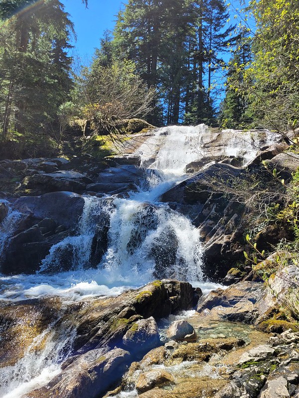
Bailey’s Chute, Marcus Falls, and Myanth Falls

PSX_20250821_083536

Similar to Dawson Falls and the Mushbowl, there’s a series of small waterfalls and water features located along the Clearwater River. The trailhead is located 55km from Clearwater town and if you want to visit all 3 highlights, it’s a 5km round trip hike through the forest. We visited Bailey’s Chute and Marcus Falls, which aren’t far from the trailhead, but decided to skip Myanth Falls in the interest of time. Personally, I actually quite liked Bailey’s Chute, we even saw a salmon jumping upstream while we were there, so I think this would be a fun place to visit during the salmon run. Otherwise, Marcus Falls is a smaller waterfall than most others in the park.

Osprey Falls

PSX_20250821_083427

Osprey Falls is located at the very end of the road, at the foot of Clearwater Lake, where the campsite is located. On its own, it’s less impressive than most of the waterfalls in the park, but is still a cool experience if you want to visit the lake. There are lots of boat tours that leave from the campsite and go up Clearwater Lake, so if you have the time, I’m sure it’s a neat experience. Osprey Falls is really just where the lake meets the river. For me, the most impressive part was just looking at the speed and volume of water cascading out of the lake. It’s located 65km from Clearwater town, so check it out if you’re visiting the lake anyways, otherwise, you could probably skip it.

There are countless other waterfalls that are accessible either by other park roads or by boat, but for this list I have just focused on the waterfalls along the main road from Clearwater town to Clearwater Lake. I definitely hope to return to this park again in the future with my kayak, but if you just have a day or two, enjoy the waterfalls on this list! Finish your day with a trip to Hop and Hog, which is a delicious restaurant in Clearwater focused heavily on beer (hop) and meat (hog). 

The Waterfalls of Strathcona Park

This has turned into quite the series about Strathcona Park, with my backpacking trips to Landslide Lake and Bedwell Bay being some of the highlights. But I want to spend a bit of time talking about waterfalls because there are so many to explore in the park and most of them are extremely easy to get to!

First up is Lady Falls. It’s located in the North end of the park along Highway 28 (as opposed to the road along Buttle Lake). If you’re going to Landslide Lake or Gold River, it’s a good stop along the way. There’s a small parking lot and it’s 500 metres each way (and 50m elevation gain) to get to the waterfall. There’s a platform from which to watch the falls thundering down into the ravine and you even catch some of the spray. Of the short waterfall hikes, Lady Falls is the easiest to get to and more impressive than Lupin Falls.

20220913_181407

If you’re heading down Western Mines Road to the south end of the park, make sure to stop at Lupin Falls on the way there. It wasn’t as impressive as Lady Falls when we visited, but that’s because it was early September and extremely dry – I suspect it has a much higher flow in the Spring. It’s flat and less than 1km as a round trip hike through the woods. The waterfall was more of a trickle when we visited, but there are some beautiful tall trees to enjoy along the way.

20220913_185252

Continuing on Western Mines Road, you’ll hit the parking lot for Lower Myra Falls at the south end of the lake, after the road for Bedwell Lakes. It’s a further drive than Lady Falls and Lupin Falls, but in my opinion, Lower Myra Falls is the best waterfall in the park (except for Della Falls). It starts with a steep hike down towards the lake, about 500 metres, but with 100m in elevation loss. There are two options for viewing – you can take the first left and see the upper falls and pool at the viewpoint – and then you can continue down to the middle falls where there’s another pool and you can explore around the rocks. You can walk along the edge of the falls as it cascades down towards the lake.

20220914_145612

Our first trip was in the early morning, so it was too cold to swim and we decided to come back later in the afternoon. On the second visit, we went for a dip in the middle pool before climbing down over the rocks to the lake – “climbing” being the key word. There are various paths cutting through the woods, but none of them are official, so we just found the least dangerous route down to the lake where there was a large sandbar. I’m not sure if the sandbar is there year round though (lake level was very low when we visited), so exercise caution around the rocks as it would be easy to slip and fall.

20220914_102344

We loved swimming in the lake. The waterfall pool was freezing cold, but the lake was a very balmy temperature and we enjoyed a proper swim before climbing back up to the parking lot. There’s a dam on the lake, so there are still all kinds of large tree stumps in the water from when they impounded the reservoir. It’s fun to swim out and stand on them, but be careful because they are slippery and have lots of sharp edges.

20220914_151637

Our last waterfall was Upper Myra Falls. At 8km round trip, this is the longest waterfall hike in the park (that we did). If I we’re to rank them all, I would put Upper Myra Falls below Lower Myra Falls and Lady Falls, but above Lupin Falls. It’s a very high, narrow waterfall that comes out through the trees and cascades down to the forest floor. There’s no accessible pool, but there is a platform from which you can view it. It took us about an hour to hike the 4km to the platform and we hung around for a half hour and had lunch before heading back again. There’s only about 80m of elevation gain along the whole trail, so it’s not very difficult.

20220914_125921

While it wasn’t my favourite waterfall, it still made for a nice little adventure. You have to drive through the active Westin Mine to get to the trailhead, which is an experience in itself, and the forest on the way to the falls is amazing! This trail is through old-growth forest, which is pretty rare in BC these days, so I enjoyed the tall, wide trees, and the chaos that makes up the undergrowth of an old growth forest.

And those are the waterfalls of Strathcona Park! There are more waterfalls that are accessible through other park entrances, the most notable of which is Della Falls and is only accessible by boat, but we only had time for the core area of the park on this trip. Overall I had a blast and would highly recommend this park, which is so large it feels more like a National Park!

20220914_104306

Hiking Crooked Falls and Sigurd Creek

It’s that awkward time of year when there’s still a lot of snow in the mountains, but we’ve finally reached the time when lower elevation hikes are becoming accessible again! I always play it really safe in the Spring because there are a lot of hazards that accompany the snow melting, but Brandon, Seth, and I went out the last week of May to do some exploring outside of Squamish.

Last Fall Brandon and I hiked High Falls Creek, which was my first time exploring in this area. We did some driving around to see what else was out there and added the Crooked Falls hike to our list – May seemed like the perfect time! Crooked Falls is located on the Sigurd Trail, which is accessible by 2WD and is just across the Squamish River when you pass the rec site.

20210529_161902

It was really busy when we arrived around 10am, but a lot of the traffic appeared to be people camping and fishing on the river. We didn’t actually pass that many people on the way up to Crooked Falls. The hike starts out on an old forestry road that heads up into the woods. It meanders around the side of the mountain before seemingly heading straight up it. It’s only 3km to Crooked Falls and 500m of elevation gain, so it’s definitely steep!

DSC08930

We took Sadie with us on this trip, which was a bit of a challenge because she’s not friendly with other dogs. She did well passing other people, but the trail is pretty narrow and everyone lets their dogs off leash, so we had to pull her into the woods whenever we would encounter another dog to try and avoid a reaction. Overall, it only happened a few times and she mostly was able to handle herself, but she did have one bad reaction to a dog that ran up in her face because it was off-leash. It’s a pet peeve for me – I have no problem with off-leash dogs (we do let Sadie off leash when there’s no one around and it’s permitted), I just wish people would ask consent before letting their dog approach you.

DSC08926

Anyways, back to the trail. Like I said, for the most part we didn’t encounter many people. After 3km there’s a branch off the left side of the trail that heads in towards Crooked Falls. Spring is a great time to visit because the falls are giant with all the run-off. There’s two small viewpoints and you do get a lot of spray off the water (as you can see in the photo), so I wore my rain coat while taking photos. We had a our lunch in the woods where we could stay dry, but still see the falls, before heading back to the main trail. Several other hiking groups came into the falls after us, so it did look like it was getting busier.

PSX_20210603_112800

It was only shortly after noon, so we decided to continue up the trail to Sigurd Creek. My guidebook indicated that hiking another 1.5km would take you to a lookout off the Sigurd Trail. While the falls are reasonably popular, we spent 3 hours on the Sigurd Trail and only saw 1 other person the whole time. It’s not the most well maintained trail and it’s steep and muddy, so I don’t really blame people.

Shortly after you leave the junction from Crooked Falls, there’s a steep 100m side trail that goes up into the woods to a viewpoint. We decided to save it for the way back, but it wasn’t the best viewpoint. It’s a bit crowded in by trees, but you can see the river down below. We continued on the trail until we came to a second junction. To the left is the Sigurd Trail to Ossa and Pelion Mountain, to the right is the Rose Trail to Sigurd Peak. My guide book pre-dated the Rose Trail, so I was a little bit confused where to go at first, but Brandon figured out that what we wanted was to follow Sigurd Creek on the Sigurd Trail and we continued that way.

20210529_130856

Unfortunately our distance tracking was a bit off because the guide book doesn’t include the Crooked Falls side trail, so after 1.5km of hiking we hadn’t reached anything that looked like a viewpoint. We did however stumble upon a second waterfall cascading down from Sigurd Creek. It was lovely and this time we had it all to ourselves, so we had a quick break and Seth refilled his water bladder. Sadie had chilled out a lot and was having the time of her time exploring around the woods.

We decided to push on a little further, but after the waterfall the trail becomes extremely steep and it was slow going. It’s another 400m in elevation gain between Crooked Falls and the viewpoint (on top of the 500m you’ve already done), so it’s definitely no walk in the park. The viewpoint indicated in my guidebook wasn’t shown on my GPS, but I made a guess about where it would be based on the topography. From the trail it really didn’t look like we were close, so Seth was ready to turn around because we were all tired from the uphill. But I persuaded him to push for another 10 minutes to the point on my GPS, because we were really close and I was convinced it was the viewpoint.

DSC08998

Fortunately I was right and a few minutes later we finally crested the mountain and could see a small knoll branching off the trail with a bare top. We climbed up to it and then collapsed while enjoying the view. We stayed up there about half an hour, snacking and guessing what mountains we were looking out at. We could see up the snowy side of Pelion Mountain and out to Cloudburst Mountain. Behind that we could see Black Tusk from a new angle and could see most of Mount Garibaldi peaking around the corner.

DSC08977

It was hot at the summit, so we gulped down lots of water and Brandon shared macarons for a summit snack. Sadie had her summit snack at the waterfall, so we gave her half of her emergency meal to give her a boost after so much climbing. She wasn’t showing any signs of being tired though and was still bounding along the trails when we started to make our way back down again.

Once we got close to the junction again, we heard a lot of people at the falls, so I guess it does still get pretty busy during the day. There were still a few groups of people making their way up, but it was 4pm, so most people were on the way down. Because of the topography, you’re on the back of the mountain, so we lost the sun around 4pm and it was surprisingly dark along the trail, even though the sun doesn’t set until like 9:30pm. Sadie was finally starting to look a little tired and nothing seemed to bother her on the way down.

20210529_165226

All together we ended up hiking about 12km. My book has Sigurd Creek round trip listed as a 9km hike, so it is a bit off. Like I said, I don’t think it accounts for the 300m branch to Crooked Falls, but even so, it’s definitely closer to 10 or 11km round trip and has a whopping 900m of elevation gain in total. So be prepared if you attempt this trail. We had a great time, but we ended up being on the trail for 7 hours and had been anticipating it would be more like 5 hours. Overall this is a great area and I’ve had a lot of fun exploring there over the last year.