Hiking Tre Cime di Lavaredo

Now that I’ve finally gotten caught up on writing about all of my summer adventures in BC, it’s time to loop you in on an exciting holiday I took in late September! If you follow me on instagram, you probably already know that I spent two weeks exploring around the Dolomites. If you’re not following me on instagram, do it! I post so many photos and reels there @mariaadey.

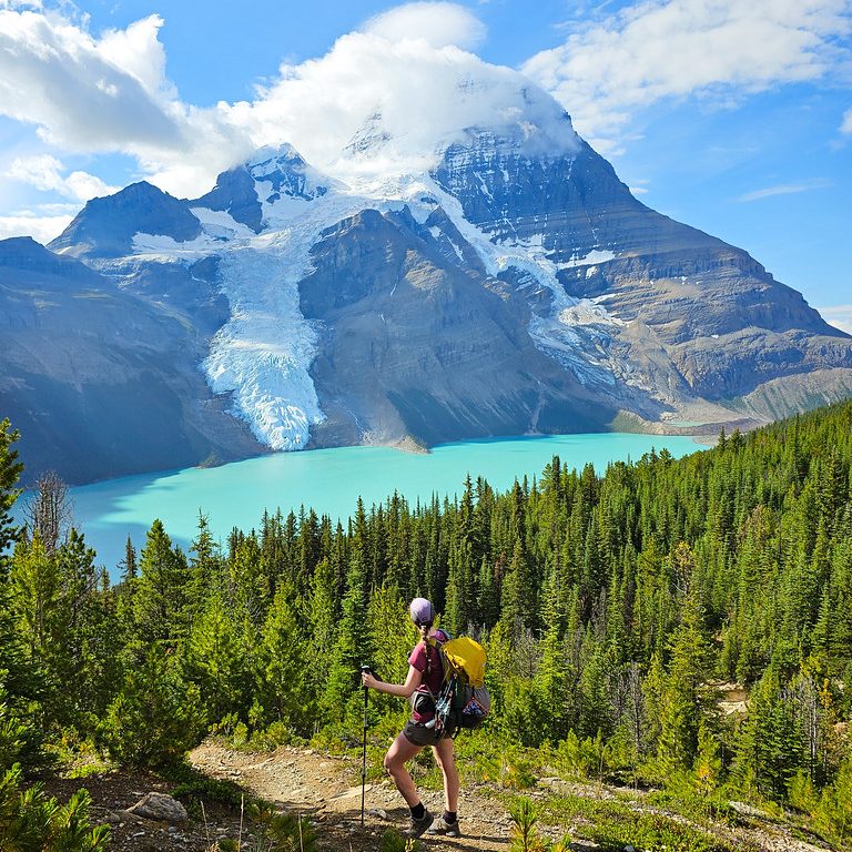
The Dolomites is a mountainous region in Northern Italy. If you follow many outdoor influencers, you’ve probably already seen photos of them because the area has become increasingly popular among hiking enthusiasts. To be honest, it wasn’t really on my radar or bucket list. I was more intrigued by the Tour du Mont Blanc in France, but when an opportunity came up to join my friend Kristine on a trip to the Dolomites to hike the Alta Via 1, I couldn’t pass up the chance! The Alta Via 1 is a popular hut-to-hut thru-hike that extends for 120km through many popular hiking areas in the region. But more on that later, first I want to focus on a very well known hike called Tre Cime di Lavaredo.

PSX_20250915_065632
PSX_20250915_065654

I flew into Venice in mid-September and immediately jumped on a bus to meet Kristine in Cortina D’Ampezzo. You may have heard a lot about it recently because it’s one of the main host cities for the 2026 Winter Olympics. We had two days in Cortina to prepare for the Alta Via 1, but while there, we couldn’t miss the opportunity to hike Tre Cime di Lavaredo, which is located just east of Cortina. I landed in Venice at 4pm, was on a bus to Cortina by 6pm, and by 8am the following morning, we were waiting to catch a bus to the trailhead. So I certainly didn’t waste any time hitting the mountains!

If you’ve been to the Dolomites, or follow anyone who hikes there, chances are, you’ve seen photos of this hike. Tre Cime is to the Dolomites, what Joffres Lakes is to Vancouver. It’s an incredibly scenic hike that is fairly easy to hike and reasonably accessible. Every tourist in the Dolomites seems to have heard of this hike and plans to do it. That might make it a little bit unattractive to some – I definitely prefer to avoid these kinds of hikes at home – but when in Italy, I don’t mind sampling the main attractions!

PSX_20250915_070643
PSX_20250915_065738

It is possible to transit to most places in Italy, but it is definitely a confusing system to navigate. Most visitors drive through the Dolomites, but even that has its challenges because crowded parking lots have led to new tolls and restrictions (not unlike at Joffre Lakes). If you want to visit by bus, you need to reserve a ticket in advance, as they will sell out. It took me a crazy amount of time to figure out the bus system and I’m hesitant to even share because the routes are constantly changing. 

In the summer, I believe you can take a bus direct from Cortina to Misurina, then pick up the shuttle to the trailhead from there. If you’re travelling in the Fall (like us), then you have to take the 445 bus to Dobbiaco, and then double back on the 444 shuttle (which goes through Misurina) to the trailhead. The 445 bus is a city bus and can be booked through the Sued Tirol Mobil app and the 444 is also a city bus, but it’s been contracted to a third party. This is the most important one to book and the bus that most often sells out. It’s called the 3 peaks hike and can be booked through Drei Zinnen https://www.drei-zinnen.bz/en/ticket.

PSX_20250915_070122
PSX_20250915_070822

Both buses travel the same route along highway SS51, so we decided to get off at Lago di Landry instead of going all the way to Dobbiaco. We had a bit of time waiting for connections, but it was a really beautiful stop next to the lake and there’s a little cafe there, so we were able to grab coffee while we waited. The 444 bus picked us up on time and we were able to bypass a lot of confused looking tourists who had parked at the lower lot and we’re looking for a shuttle up to the top of the road where the trail starts. 

The trailhead is located next to Rifugio Aurenzo, so it’s a good landmark for planning your day. It’s actually the trailhead to two different hikes: Tre Cime di Lavaredo and Cadini di Misurina. I would say that Cadini di Misurina is just as popular as Tre Cime and I would have loved to do both, but I read that Misurina is a shorter hike with a popular viewpoint that gets extremely crowded with a line to the summit. Tre Cime is also crowded, but due to the longer trail, people get somewhat dispersed. So we just did Tre Cime, but maybe one day I’ll go back for Misurina. 

PSX_20250914_222325
PSX_20250915_070902

Like I said, we visited in mid-September, but we did this hike on a Sunday, so it was still extremely busy. We got some excellent views as we were driving up the road to the trailhead, but it was quite cloudy when we arrived at the top. The nice thing about this hike is that it’s a loop, so you don’t have to re-do any of the terrain. You can hike in either direction, but more people like to do the route counter-clockwise – it’s supposed to make the elevation gain easier. 

The hike is certainly forgiving when you start, as you walk along a wide road that looks down over the valley. We didn’t get many views on the way out due to the clouds, but Kristine is a huge livestock enthusiast and there were lots of cows, so she was running around trying to photograph them all. It’s ~1km of easy walking to a small church that looks out over the valley, and then another ~600m to the first hut of the trail: Rifugio Lavaredo. In total there are 4 huts along the route (including Aurenzo at the trailhead), but Lavaredo was my favourite one. Kristine was immediately distracted by the hut’s pet goats, while I purchased our first sweet treat of the trip! 

PSX_20250915_070233
20250914_125914(0)

One thing I quickly discovered about Italy is to enjoy the opportunities for sweet treats and coffee. Unfortunately I am not a coffee drinker, which was too bad because there’s a huge coffee culture there, but Kristine would always grab a cappuccino and we quickly started making our way through as many of Italy’s sweet treats as possible. The first one was a cannolo, which was a chimney cake filled with cream. It was delicious, but rarer than we thought, as I didn’t encounter any more hut cannolo’s until the end of the trip! We hung out for a while at the hut in order to give the clouds some time to clear off. It didn’t really work, but we still enjoyed the break.

After Lavaredo, you head up towards Tre Cime, which translates to “three peaks”. It’s ~1km to hike up to the top of the pass. You can follow the road, or take the shortcut along the mountainside. We just followed the road because it’s less steep. It was very busy at the top of the pass and from there, a lot of people branch off to explore via ferratas and other routes. I would say that the top of the pass is one of the best views on the trail, so take the time to enjoy it. We had a great view looking down the other side of the pass to the next rifugio, but the peaks were still shrouded in cloud. Personally, I think this just added to the experience and we got cool misty photos of the huge rock monoliths. 

PSX_20250915_070956
PSX_20250915_070309

At this point, we’d hiked less than 3km at a very slow pace, so we decided we had to try and pick things up a bit. This was easier said than done as the views are so incredible along the entire route and we were constantly taking photos. I took 500 photos over the course of the day, which I thought was a bit extreme for one hike, but Kristine took over 800, so I finally found someone even more enthusiastic! 

It’s a pretty easy walk down from the pass, but there is a short climb to get up to the next rifugio, which is known as the Dreiszinnenhutte. It was the biggest hut on the trail and a popular place to stop for lunch. The hut looks down on a small lake and there’s another little chapel next to the hut. One of the first things I was surprised to learn was how heavy the German influence is in the Dolomites. The hut architecture throughout the region is very Bavarian, as is the cuisine. I was expecting to see lots of pizza and pasta, and while there was pasta, I didn’t see a lot of pizza. Instead, there was lots of bratwurst and schnitzel on the menus. 

PSX_20250915_070402
PSX_20250915_070554

Kristine ordered a bratwurst for lunch and I ordered a “split pea soup with dough balls”. If you’re from Newfoundland, you can definitely guess what I was envisioning for this meal. A thick, pureed split pea soup with balls of cooked bread. What I actually got was a thin and greasy vegetable broth with green peas that had been battered and deep fried. Honestly, it wasn’t a bad meal, but it definitely didn’t sit well in my stomach after so much traveling. But at the time, we enjoyed a nice lunch break with some German beer.

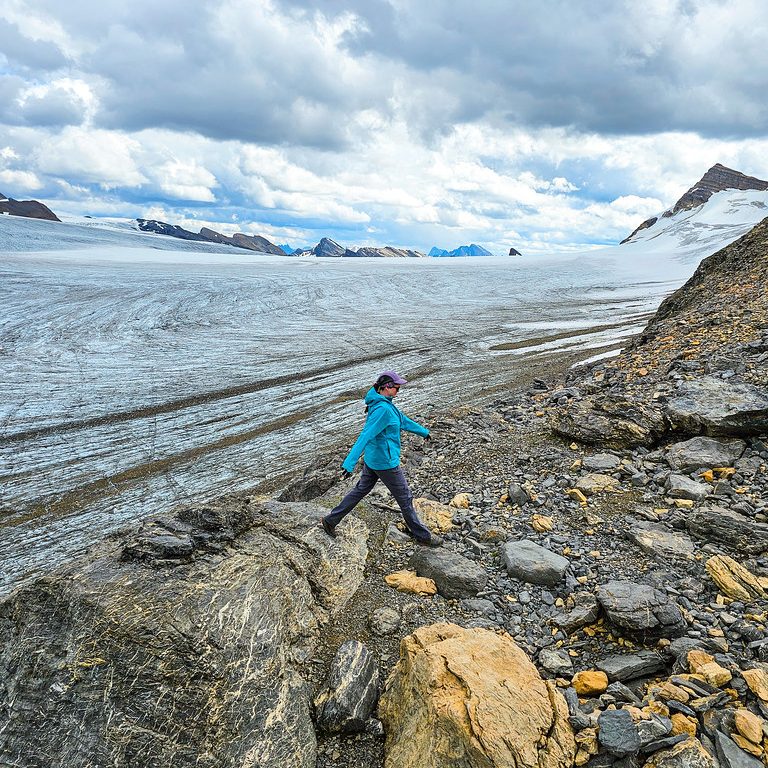
Dreizinnenhutte marks the halfway point of the hike, so we continued on after lunch with some downhill switchbacks through the alpine. I think this section of trail is why it’s recommended to hike counter clockwise – the switchbacks make for a tiring hike if you walk the other direction. We still stopped a lot for photos along the way. It was our first introduction to the Italian alpine environment, which is very barren. I’m sure it’s not helped by the fact that we were heading into Fall and everything was dying, but it did surprise me how accessible the alpine is in Italy. I’m used to hiking all day through the trees to get to the alpine in Canada, but in Italy, you can easily start and finish in the alpine. It makes for a scenic hike, but it can also be very tiring with the lack of shade. Fall seemed to be the perfect time for us. It was still warm enough to wear shorts most of the time, without having to deal with summer levels of heat. Although it was still hotter than we’d anticipated.

PSX_20250915_071040
PSX_20250915_071956

What was disappointing to see was all the people not following leave no trace principles. In the same way that people like to stack rocks in North America, people have gotten into the habit of re-arranging rocks in the alpine to spell out names and messages. There’s a large flat valley at the bottom of the switchbacks and the entire meadow was filled with rock signs, which really mar the landscape – it was sad to see.

After crossing the valley, we were rewarded with a big climb up the other side. It was a struggle as it was getting warmer, but we crawled our way up to the top and continued on to the last hut of the day. The clouds had lifted a lot since we’d started the hike and we got a great view of the three peaks along the last section of trail. We stopped at the final hut and got some photos hear a little pond that made for a nice viewpoint. After the hut, you crest the top of the pass and you get a view out towards Cadini di Misurina, so we stopped here for a while to admire the jagged peaks, and then concluded the hike at Rifugio Auronzo. 

PSX_20250915_145504
PSX_20250915_071412

We celebrated with an apple strudel and boarded our bus back to Cortina. We stopped again at Lago di Landry, but the cafe was closed for the day. I temporarily freaked Kristine out with a malfunctioning bus ticket for the last segment of our trip. This was my first time using an e-sim while traveling (usually I buy a sim card locally or just go without). The e-sim was a really cheap and an easy way to use data while traveling and I’ll definitely be using it again, but sometimes my phone would get confused choosing between networks and we weren’t able to load our bus ticket at the lake because there was limited service. The bus driver let us ride anyways and I eventually figured it out, but overall, the bus system is really not very intuitive. 

Either way, I felt that Tre Cime was a great introduction to the Dolomites! I’m glad we did it before the Alta Via, because I think it wouldn’t have been quite as impressive after a week on that trail, but I really did enjoy the experience, in spite of the large crowds. If you want to visit, make sure you do take the time to plan out your trip and how you will get there, because you won’t necessarily be able to visit on the fly. Be prepared to do the hike with 5000 other people, but fortunately, the views will outshine the crowds!

PSX_20250914_221629
PSX_20250915_074357

Berg Lake Trail Backpacking Guide

The Berg Lake Trail is one of the most iconic backpacking trails in the Canadian Rockies. It’s been on my bucket list for a long time, but it was closed for 3 years due to flooding that washed out portions of the trail in 2021. It finally re-opened in 2025 and I was super keen to visit the same summer. I spent 6 days hiking along the trail and it was easily the highlight of my summer! I’ve already published a 3-part trail report about my experience, which you can read starting here, but I had a lot of other learnings about the trail that I’d love to share. Reservations for the 2026 season are releasing at 7am on December 2, 2025. so here’s everything you need to know about the Berg Lake Trail!

The Trail

The Berg Lake Trail is a 42km there-and-back trail located in Mount Robson Provincial Park in BC. The trail starts at the parking lot north of the visitor centre and continues for 21km to the beach at the back of Berg Lake. There are 7 campgrounds in the park, with the most popular being the Berg Lake Campground.

There are a few options for how to hike this trail. If you’re not a backpacker, it is possible to day hike the entire thing, but you should give serious consideration to your fitness ability and previous hiking experience if you decide to attempt it. While the trail itself is not technical, it is a considerable distance and it covers almost 1000m in elevation gain. Approximately 500m of the gain is done in a 3km span, so it is a challenging and tiring hike. If you are not used to hiking long distance or you don’t have experience hiking in the mountains with significant elevation gain, I strongly recommend against attempting this as a day hike. If you do plan to day hike, I recommend starting before sunrise to give yourself lots of time, or consider biking as far as Kinney Lake. I found that the day hikers were primarily tourists who either don’t camp, or weren’t aware of the lead time required to secure permits.

If you are able to backpack it, I think this is a more enjoyable way to experience the trail. I did the trail over 5 nights, splitting the trail into 2 parts on the way up and down, and then camping 3 nights at Berg Lake to do day hikes. If you have more time to spend in the park, there’s lots to explore, but you can also enjoy this trail over a shorter period. I’d recommend a minimum of 2 nights. Most likely your itinerary will be limited by what permits you are able to obtain.

A photo of a female backpacker on a mountain overlooking Berg Lake and Mount Robson on a sunny day, on the Berg Lake Trail in Mount Robson Provincial Park in BC.

Time of Year

The best time of year to visit the Berg Lake Trail is pretty straight-forward. Mount Robson is the tallest mountain in the Canadian Rockies, so the trail is covered in snow for most of the year, limiting the core hiking season from late-June to mid-to-late September. You can visit year round, but you must be prepared for winter conditions and be aware of avalanche risk, which I won’t be discussing in this post.

I think there is slightly less traffic in September, as it gets cold quickly in the Rockies, but otherwise, avoiding the crowds isn’t really possible. If you go in late-June, be aware that there may still be snow on some of the trails; and if you go later in the summer, it’s more likely that your trip might be impacted by wildfires. Mid-to-late July might be the sweet spot, but I visited during the first week of August and lucked into great conditions. The mountains are always susceptible to storms, so be prepared for that.

Getting There

I think it may be possible to take a bus to Mount Robson Provincial Park from either Jasper or Kamloops in the summer, but it’s not a common route and I don’t know how reliably buses run. Similar to other popular Canadian parks, the easiest way to access is by driving. The park is located on Highway 16, which is a 5 hour drive from Edmonton, 7 hours from Calgary, and 7.5 hours from Vancouver (all without breaks). It’s not an easy park to access, but I promise it is worth your time. There is a very large parking lot at the trailhead, which is relatively secure, but never leave valuables in your vehicle.

Permits

Without a doubt, getting permits will be the hardest part of your trip to Berg Lake. This is a world-renowned hiking trail and attracts crowds of visitors every year. If you don’t get camping permits, then day hiking may be your only option to visit the park. If you want to try and get camping permits, then it’s important to mark your calendar with the permit release date. The permit release date for 2026 is Dec. 2, 2025. Unlike other BC parks, the permits for the Berg Lake Trail are released all on one day. The date is usually announced on the Mount Robson Provincial Park page, as well as on BC Park’s instagram. They usually don’t give a lot of notice (1-2 weeks), so you should be prepared to check in regularly at the end of the year until it is announced. The easiest way is to follow their social media.

Once released, you will have to book your permits on camping.bcparks.ca. Unlike Parks Canada, there is no random queue generator and you will have to login to your account, so there is no benefit to using multiple devices to try and get higher up the queue. However, if you have multiple people going on the trip, it is advantageous if you all login to your respective accounts to try for reservations (effectively giving you multiple chances to get your desired itinerary). I recommend creating an account in advance of release day (when the website will likely be slow due to traffic) and logging in before the sites release.

Once booking opens, select “backcountry reservations” and search for your start date. You will be forced to build your itinerary day by day, which can be a little frustrating. Once you get a date in your cart, you don’t need to worry about losing it, but it will become more challenging as the dates book up to continue building the itinerary. For example, by the time you get Whitehorn in your cart for your first night, Berg Lake may no longer be available for your second night. People are constantly adding and changing dates and campsites in the rush to get their itinerary, especially if you have multiple people from the same party trying to make 1 booking. So the trick is to frequently refresh. Just because you don’t see Berg Lake available right away, doesn’t mean it won’t show up if you keep refreshing.

My recommendation for booking a longer itinerary is to take what you can get and make changes later. If Berg Lake is not available, book Marmot or Rearguard and move on to the next day before those dates book up too. Once you have secured a booking for each of the dates in your itinerary, go back and look for cancellations. Keep refreshing until you see one, and then make a change to your booking to add it. This does cost more money as the change fee is $6, but I was able to get bookings for Berg Lake after the fact using this hack. When I made my first booking, I had 3 nights split between Marmot and Robson Pass campsites. I was able to change my reservation from Robson Pass to Berg Lake within the hour from people dropping sites, and I was able to get a cancellation later in the season and change my booking from Marmot to Berg Lake. So in the end, my starting itinerary (which had no nights at Berg Lake) ended up with 3 nights. You can track cancellations on Schnerp, which will notify you when a site opens up.

A female hiker walks in front of an epic glacier icefield at the top of Snowbird Pass in Mount Robson Provincial Park, off the Berg Lake Trail, in BC.

Campsites

There are 7 backcountry campsites in the park, so there are lots of options for where to stay and opportunities to customize your trip. The first 3 campsites are located along the trail to the lake, while the last 4 campsites are all located within 3.5km of one another around the lake. I’ll discuss itineraries below, but here’s an overview of the 7 campsites along the trail. All campsites include outhouses and bear lockers and as discussed above, require valid permits for the duration of your visit.

Kinney Lake – This is the first campground, located right on Kinney Lake at the 7km trail marker. It has 18 tent sites and a large open-air shelter. It’s a beautiful campground with several lakefront tent pads and a lovely view from the shelter. The trail to Kinney Lake is a gentle uphill, so this campsite is often overlooked because it is less than halfway to Berg Lake. But it’s a great option if you have a late start on your first day, as well as for families or those who want to experience Mount Robson’s backcountry, but have concerns about the strenuous hike up to Berg Lake. There are bike racks located at the back of Kinney Lake for those who bike up.

Whitehorn – This campground is located along the Robson River at the 11km trail marker. It has 22 tent sites and a large open-air shelter. This campground is ideal if you’re looking to split the hike to Berg Lake in half. It splits the elevation gain in half as well, though day 2 is slightly more strenuous. Some of the tent pads are along the river, while others are in the woods, but there’s a beautiful view of the valley and the backside of Mount Robson from the campground.

Emperor Falls – This campground is located just past the viewpoint for Emperor Falls at the 16km trail marker. It has 9 tent sites and some picnic tables, but it does not have a shelter. While the tent pads are located right next to the river, making for a nice view, the main downside to this campsite is that it’s located at the top of all of the elevation gain, so it leaves you with a big day if you’re hiking from the parking lot. I would probably avoid it on the way up, but it’s a good option to shorten your hike on the last day.

Marmot – This is the first of the upper campgrounds, any of which can be used as a base for day hikes. It’s located at the foot of Berg Lake at the 19km trail marker. It has 7 tent sites and a recently constructed semi-enclosed shelter (this one has windows, unlike the shelters at Kinney Lake and Whitehorn). Most of the tent pads are located in the woods, but 1-2 have a direct view of Mount Robson. While the view from Marmot is not quite as good as from Berg Lake, it is located right on the lake and would be my first choice if I couldn’t get a site at the Berg Lake Campground. Some people really like this campground because of how small it is, so you can avoid the crowds.

Berg Lake – This is the most popular campground on the trail. If you can score a permit for this campground, do not hesitate to book it. It’s located at the head of Berg Lake at the 21km trail marker. It has 26 tent sites and a fully enclosed cooking shelter with a large porch and view of the Berg Glacier. This is the most beautiful campsite on the trail, but it will be very busy as a result. Most of the tent sites are in the woods, though there is one premium tent pad with a lake view. A few of the sites at the back of the campground also have mountain views.

Rearguard – This campsite is located just past the Berg Lake Campground at the 22km trail marker. It has 6 tent sites and is a good option if you weren’t able to get a campsite at Berg Lake. It’s not located on the lake, but it does have nice views of Mount Robson and the river delta. The main downside is that there is no shelter, so if it rained, I’d prefer to be at Marmot.

Robson Pass – This is the last campsite in the park, located at the 23km trail marker. It has 15 tent sites. It’s located a little bit further away, but it can still be a great base if you’re planning to do some day hikes. You can access Snowbird Pass from this campsite, as well as you can hike up the backside of the Mumm Basin Trail – although be aware that this trail no longer connects to the Toboggan Falls trail due to a rockslide in recent years – but I’ve heard it still has a great view. Similar to Rearguard, the main downside of this campsite is that it doesn’t have a shelter.

Robson Hut – Another option to be aware of in the future is that the ACC is currently constructing a brand new mountain hut at Robson Pass, which should be open for the 2026 season. You will be able to book this hut through the ACC and it will be the swankiest accommodation available in the park. Please note that this is separate from the BC Parks booking system and it is not an open hut that you can visit. A booking will be required to use the hut.

Robson Meadows – Just to cover my bases, I want to mention that there is a frontcountry campground located off the highway near the visitor centre, which is a great option for camping the night before or after your backpacking trip.

A photo of Mount Robson on a sunny day with the Robson River in and trees in the foreground and the mountains and glacier in the background, on the Berg Lake Trail in Mount Robson Provincial Park, BC.

Itineraries

I’ll keep this fairly simple. It’s not easy to get permits, so it’s really a take what you can get scenario, but there are a few strategies you can employ.

Strategy 1: Hike all the way to Berg Lake in a day. The idea with this strategy is that you book as many nights as you want at the lake, prioritizing day hikes from the lake. The benefit is that you can immediately concentrate on getting bookings for Berg Lake before they fill up and maximize your time at the lake. The downside is that you need to be prepared to do the full 21km in a day, which is challenging, but allows you to spend more time at the lake if time is limited.

Strategy 2: Break up your hike to Berg Lake into 2 days, staying at one of the middle campgrounds on the way up, but planning to hike all the way back to the parking lot in a single day. Again, book as many nights as you want at Berg Lake after you arrive. This makes your hike in easier than strategy 1, but still gives you extra time at the lake, as the hike down is much easier than the hike up.

Strategy 3: Break up your hike to Berg Lake into 2 days on both the way up and down. If you have more time available, you can still book multiple nights at Berg Lake in the middle to do day hikes, but the benefit is it gives you a more relaxed hiking timeline, especially if you are worried about the challenging terrain.

Personally, I would only do strategy 1 if I only had 1 night. I used strategy 3 for my visit because I had lots of time, but I would have been comfortable with strategy 2 as well. It is more manageable to do the hike down in a single day. Here’s a couple of options based on the number of nights you have. (D=day, N=night)

Number of NightsFirst Choice CampgroundAlternate Campgrounds
2 days, 1 night (strategy 1)D1: Hike to Berg Lake
D2: Hike out
Marmot, Rearguard
3 days, 2 nights (strategy 1)D1: Hike to Berg Lake
D2: Day hike, stay at Berg Lake
D3: Hike out
Marmot, Rearguard
3 days, 2 nights (strategy 2)D1: Hike to Whitehorn
D2: Hike to Berg Lake
D3: Hike out
N1: Emperor, Kinney Lake
N2: Marmot, Rearguard
4 days, 3 nights (strategy 2)D1: Hike to Whitehorn
D2: Hike to Berg Lake
D3: Day hike, stay at Berg Lake
D4: Hike out
N1: Kinney Lake
N2: Marmot, Rearguard
N3: Marmot, Rearguard
4 days, 3 nights (strategy 3)D1: Hike to Whitehorn
D2: Hike to Berg Lake
D3: Hike to Whitehorn
D4: Hike out
N1: Kinney Lake
N2: Marmot, Rearguard
N3: Kinney Lake, Emperor
5 days or moreSame as 4 day options, but add multiple nights at Berg Lake

Day Hikes

There are several great options for day hiking along the Berg Lake Trail. I really think it’s worth it to try and fit in at least one day hike if you can get multiple nights at campsites near the lake, but if you can’t, it’s not the end of the world either. Berg Lake is a world-class trail on it’s own and the entire trail is stunning, whether you have time for side quests or not. If you do have time, here’s the trails I would recommend.

20250805_105047

Snowbird Pass – In my opinion, this is the best trail in the park. People like to prioritize the Berg Lake Viewpoint on the Toboggan Falls Trail, but this trail is the real gem. It’s a 20-km round trip hike from the Berg Lake Campground, so you definitely need a full day for it, but it features views of both the Robson Glacier and the Reef Icefield. It’s stunning from start to finish. If you don’t have enough time to do the whole trail, it’s still worth it to hike the 3km from Berg Lake to the lake at the base of Robson Glacier. I’ve written an entire blog post about this trail.

Toboggan Falls to Berg Lake Viewpoint – This is the most popular side trail in the park. From the Berg Lake Campsite, you can hike 1km up along the Toboggan Falls trail (enjoying the view of Toboggan Falls along the way), to a junction that takes you another ~1km up to the Berg Lake Viewpoint. From here, you can get the iconic photo of Berg Lake, the delta, and Berg Glacier. You don’t need a full day to do this hike, so if you’re short on time, you can probably knock it out in ~2 hours after you arrive at camp.

Hargreaves Lake Loop – If you have a full day, expand your hike up to the Berg Lake Viewpoint to also include the loop around to Hargreaves Lake via Marmot Campground. It’s approximately 7km round trip and in my opinion, Hargreaves Lake is really underrated. There’s a small viewpoint off the trail that takes you up to a lookout of Hargreaves Glacier and the Marmot branch of the Berg Glacier at the same time. I’d recommend a day if you’re doing the whole loop, but if you’re staying at Marmot, you could easily hike up to Hargreaves Viewpoint and back in an evening, as it’s only ~3km round trip.

Adolphus Lake – I haven’t done this trail myself, but if you have the time, you can hike out from Berg Lake to Robson Pass and then continue on to see Adolphus Lake. It’s ~2.5km from the Berg Lake Campground, but along completely flat ground. It’s a great option if you’re staying at Robson Pass.

20250805_114645

A Day in Belem

This marks my last post about my Europe Trip! After a week in Morocco, we flew back to Lisbon for 1 more day before returning to Canada. Our flight was delayed, so we didn’t arrive in Lisbon until really late at night and stayed in a hostel right outside Rossi Square. Overall, I felt like we didn’t really have enough time in Lisbon. I would have liked to do a food tour and spend some time exploring the Alfama neighbourhood, but we didn’t have time for everything.

On my first visit to Lisbon (12 years previous), I had regretted not going to Belem. I don’t really think Belem is any more special than any other part of Lisbon, but the Tower of Belem seems to show up on lots of travel bucket lists and I’ve always been a little disappointed I never did it. So we dedicated our last day in Lisbon to exploring the neighbourhood of Belem.

20240607_110132
20240607_122709

First we got up and had a nice brunch in Lisbon city centre, and then we caught the iconic 15E tram line that runs all the way from City Centre to Belem. It’s supposed to be one of the best routes for tourists and it gets really busy as a result. I didn’t find it too bad on the way there, but we forgot to top up our Metro cards and had a hard time getting tickets. The tram runs right through Belem and we got off at one of the last stops to walk over to the Tower. 

Emily had purchased tickets online in advance, but they are not timed entry. We thought the tickets would save us from the worst of the line-up, but talk about a scam! The line-up to buy tickets is really short, but the line-up to get in the tower is still really long. It made me mad because once you buy the ticket online, you’re committed to going. You’ve already spent the money and can’t opt not to go if the line is long (without losing your money). I don’t know why they don’t do timed entry like in Sintra. 

20240607_132050
20240607_141251

The line-up wait was forecasted at 2 hours, but it was moving pretty quickly and we ended up getting in after ~45 minutes of waiting. The downside was that it started to rain while we were waiting in line with no shelter. A few opportunistic vendors came by selling umbrellas, but we opted to wait it out in our rain jackets. 

Fortunately, the tower is really cool, and because they only let so many people in at a time, it’s not crowded. The tower is constructed on a rock formation on the beach and was built by the King as a military fortification in the early 1500’s. The structure has been expanded on over the years and it underwent a full restoration in the 1990’s, after which it was added to the list of the seven wonders of Portugal. Also on this list is Pena Palace, which we visited in Sintra, and Jeronimos Monastery, which is located just down the street.

20240607_134031
20240607_135940

We could have made it a double feature and visited the monastery as well, which in my opinion, was a much larger and more architecturally interesting building. But we wanted to actually relax on our last day of vacation and didn’t want to spend another hour waiting in line. Instead, we spent the afternoon walking along the waterfront, where we saw the Belem Lighthouse, the Padrao dos Descobrimentos (a monument to Portuguese navigators), and did a little bit of shopping at a local market. 

We walked along the main road to see the Jeronimos Monastery from the outside, and then decided to visit Pasteis de Belem, which is a famous pastry shop. It is absolutely massive, so we didn’t have trouble getting seated, but we also waited a long time to be served. We enjoyed tea and pastel de nata (Lisbon’s famous egg custard pastry), along with a mille feuille for me and chocolate cake for Em. It was all delicious!

20240607_143711
20240607_150755

We caught the bus back to Lisbon at rush hour, which was extremely chaotic, but also hilarious because I was seated in front of a Portuguese woman who was emphatically chastising her friend Maria for the entire journey. She said her name approximately 10 dozen times and I couldn’t help but feel I had let her down somehow. 

We finally made a trip to the local liquor store to stock up on wine to bring home. I ended up getting more bottles than the duty free allowance (which also happened to me in Patagonia), but like Patagonia, no one questioned me or made me pay duties on the extra wine, so definitely don’t be limited by the allowances when returning to Canada (yes, I did declare it)! We picked a nice restaurant in the City Centre and had a fantastic meal before preparing to return home. 

20240607_155309
20240607_192934

It was a long journey home. We flew through Montreal, where my absolutely massive flight to Vancouver got cancelled. Luckily, I got the notification on my way to the gate and I immediately took off running to customer service to be the second person in line. So I immediately got re-booked for the following morning and booked into a hotel. The bigger problem was that they did not release my luggage. I had (even more) duty free wine that I bought in the airport. It had to go in my checked luggage once I left the terminal, so I had to wait around for 3 hours while they tracked down everyone’s luggage. I seem to have inordinately bad luck flying, but I did get a $1200 Air Canada voucher out of it, which I immediately used on 2 flights to Newfoundland, so I guess it wasn’t the end of the world.

This was the first time me and Emily travelled internationally together since we went to Costa Rica in 2016, so we were long overdue for a sister trip and we had a great time! The Azores were my favourite part of the trip, but Morocco was also a very unique experience and unlike anywhere else I’ve been. The food was also a big highlight, with the seafood in the Azores and the flavours of Marrakesh being particularly memorable. And of course, seeing Taylor Swift in concert is worth every bit of the hype and an experience I hope to repeat one day soon!