Bedwell Lake Backpacking Trip

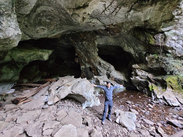
One backpacking trip wasn’t enough for Brandon and I when we went to Strathcona Provincial Park and we ended the visit with a second trip to Bedwell Lake. Like Landslide Lake, it seems that Bedwell Lake is another popular hike. The trail to Bedwell Lake is located in the center of the park, at the far south end of Buttle Lake, so it’s a longer drive to get to. Once you get to the toe of the lake, there’s a side road that goes up into the mountains towards the trailhead. There are warnings that you need 4WD to get to the trailhead, but it really depends on the time of year and when the road was last graded. It’s a gravel road, but it was in pretty good condition when we visited and 4WD definitely wasn’t required, but I’d want to have a bit of clearance (i.e., an SUV over a little car).

20220915_120558

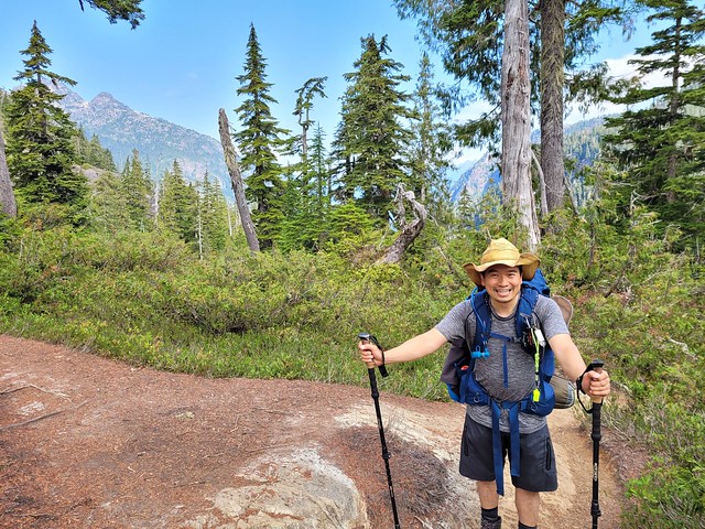
Get your permit online in advance or bring cash for the self-pay permit box. I don’t usually avail of self-pay, but we didn’t pre-plan this trip and there was no service in the park, so we used cash to get our passes. The trail is pretty flat for the first kilometre, but it’s a steady uphill after that. The trail isn’t very technical, but it gets steeper as you go and there are several metal stair and chain sections closer to the top. It’s roughly 4.5km to Baby Bedwell Lake, which is just before Bedwell Lake and where the first campsite is located. From there, it’s another 2km to the back of Bedwell Lake, which is where the main campsite is. The section between Baby Bedwell and the main lake is the most challenging because you go over the headland between the lakes and it’s mostly stairs and ladders.

20220916_102408

From the main campsite, you can climb up over the saddle and continue to Cream Lake, which is about 5km further. It’s supposedly very scenic up on the ridge, but it started to get foggy the closer we got to Bedwell Lake. There wasn’t any rain in the forecast, but the weather can do weird things in the mountains and on the day we visited, the clouds got caught up around the mountain peaks. The visibility deteriorated the higher we got and we were pretty cold climbing up to the lake.

We got there around 12:30pm and stopped for lunch, but at the same time I turned on my inreach and got a flood of messages from Seth at home. It turns out someone had stolen the catalytic converter from our car and Seth was having a really hard time making a claim since the car is in my name. So I spent the better part of an hour messaging with him to help get things sorted and then we had to decide what to do about the rest of the hike.

20220915_121837

It was really cold sitting by lake in the fog, so we knew we had to keep hiking to stay warm and kill some time, but neither of us were feeling up to lugging our backpacks uphill to Cream Lake. I was feeling anxious about Seth and I didn’t really see the point of hiking uphill in the fog for no view. So we decided to set up camp at Bedwell and go for a day hike up to Little Jim Lake, which is the halfway point between Bedwell and Cream Lakes. In retrospect, I kind of regret not going the whole way to Cream Lake. The fog was like soup up there, so we definitely wouldn’t have seen anything, but it did start to clear a bit the next day, so we may have gotten lucky on the return trip. But it’s hard to say either way and I think we made the best decision we could based on how we felt at the time. I had a great trip to Strathcona with Brandon, but I had hiked 130km on the SCT just a week previous and this was the last thing we were doing in Strathcona, so I admit I was a little fatigued and ready to go home by this point.

20220915_153608

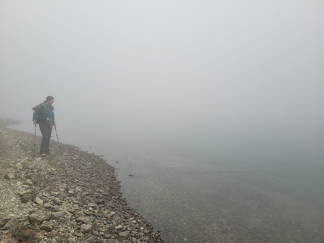
In any case, we made the best of it and hiked up over the ridge to Little Jim Lake. It was still an entertaining experience walking around in the fog. It was so thick we could barely see in front of us and it made for a bit of a spooky experience around the lake. Sound travels really well over the water, so we could hear other hikers on their return trip, but it seemed to be forever before they would actually materialize out of the fog, even though we’d been listening to the din of their voices across the water for many minutes before. We had a snack by the lake and then turned around in time to go back to Bedwell Lake for supper.

20220916_091852

At this point it hadn’t yet rained, but it was getting a bit misty at the lake when we returned, so we quickly starting on our evening chores and ate supper before it truly rained. We made friends with 2 dads, one of whom was bemoaning the fact that his son-in-law had misplaced part of his tent without telling him and now he’d been left without a fly for the weekend. So the two were whining that they would have to share a 1 person tent overnight, which we found a lot funnier than they did. So PSA, always check your gear after loaning it out! (or as I’ve learned from girl guides, any time you’re going on a trip)

Eventually it started to properly rain, so we went to bed early and I spent the evening reading in the tent while Brandon stared at the ceiling. The poor guy had broken his phone earlier in the trip, mistakenly thinking it was waterproof, and he had absolutely nothing to do, so eventually I took pity on him and gave him my phone to play some games until we finally retired for the night.

20220916_094024

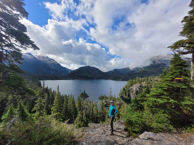
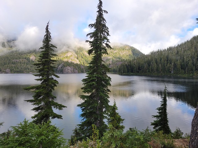
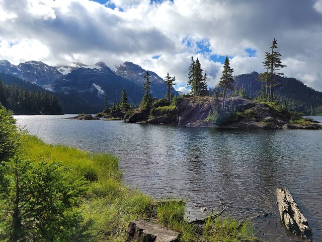
It drizzled most of the night, but fortunately it had stopped by the time we got up in the morning. It was still very cold and foggy, but we were optimistic that the clouds were starting to break up, so we made a hot breakfast to warm up before packing all our gear. The clouds never fully cleared, but they lifted the longer we hung around and we finally got a glimpse of the lake and terrain as we started our return trip. The climb over the headland felt a lot less intimidating without the fog and we ended up stopping at the top for about half an hour to explore and photograph some of the smaller viewpoints.

20220916_103553

Likewise, it was a much faster journey back to the car than on the way in since it’s a steady downhill. Overall it wasn’t my favourite hike, but I’m glad we at least got a glimpse of the area on the way down. It’s always disappointing to hike somewhere and not get a view, especially when it’s somewhere remote and it’s unlikely you’ll get the opportunity to come back soon. But mentally I just wasn’t really prepared for this hike. I was ready to go home. We’d planned to stay one night in Courtney before catching the ferry, but we ended up driving straight out of the park and all the way to the ferry after finishing this hike. So not every hike is a home run, but it was still a special experience and I’m definitely keen to go back in the future and hike all the way to Cream Lake. I feel like we’ve only scratched the surface of Strathcona Provincial Park after this trip!

20220916_110059
Advertisement

Landslide Lake Backpacking Trip

I didn’t know much about Strathcona Provincial Park before we decided to visit, but after a google search I quickly arrived at the conclusion that Landslide Lake is one of the most popular hikes in the park. Vancouver Island isn’t really known for its mountains. Even though I know the island has mountains, it’s always the coastal hikes that come to mind when I think of the island, so I was keen to do Landslide Lake and explore some of the more mountainous regions.

We spent the first night car camping and got up early to hit the Landslide Lake trail. It’s right off the highway on the way to Gold River. It was a weekday in mid September, so there were a lot more cars in the parking lot than we were expecting. It seemed several large groups had camped up there overnight, but most of them were exiting the trail as we were hiking in.

20220913_185252

It’s not a challenging trail. It starts with a short uphill climb before leveling out along Elk River. It is mostly uphill, with some slightly technical sections, but overall not a difficult trail. It just feels long. It’s around 7km to the first campsite at Butterwort Flats, which is located next to the river but primarily in the trees, then it’s another 3km to Upper Gravel Bar Campsite, which is where we were planning to stay. It took us around 3 hours at a pretty brisk pace to reach the campsite.

20220912_172753

There was no one there when we arrived, so we set up our tent along the river and had lunch. It’s another 3km to Landslide Lake, but you’re not allowed to camp there, so people just day hike up and back from the campsite. It’s steeper heading up to the lake and the trail can be a little bit confusing at times. There’s a lot of uphill over bare rock and while it’s really obvious which direction you want to go (due to the valley), it’s easy to lose the trail, so watch for the cairns. It took a bit longer than we were expecting due to the heat, but there’s a nice waterfall on the way up and eventually we made it to the lake. There were a few day hikers there, but they soon took off and we went for a swim in the cold water and had a snack.

IMG-20220918-WA0004

We probably should have called it a day there, but both of us were keen to check out Foster Lake (aka Iceberg Lake) while we were up there. It’s only about 1.5km to the next lake, but there’s no official trail and it’s a bit of a bushwack at times to get there. We didn’t really have trouble following the trail, but it’s really technical with lots of brush and ups and downs, so we were cursing and swearing pretty much the whole way there. It’s very forested around the back of Landslide Lake and then once you get to the end of the lake, you follow the creek bed for a bit before climbing up over scree and boulder fields. To be honest, some of the best views of Landslide Lake are from the boulder field at Foster Lake, because the angle of the afternoon sun from the base makes it hard to get any good photos.

20220912_144055

We strongly debating throwing in the towel and turning around, but we’d come so far and knew we were unlikely to come back, so we kept going while we grumbled. I am glad we persevered, but my advice to others would be to either give yourself an entire day for it (2 nights at the campsite), or skip it. I can’t deny Foster Lake is pretty cool, it’s definitely alpine terrain and there’s a glacier at the back of the lake that you can explore if the conditions are right. If we had a whole day for it I wouldn’t mind exploring around the area a bit more, but we had less daylight because it was September and we were tired from the hike in. We enjoyed the view for 15-20 mins before turning around and heading back to make supper. The trail was just as annoying on the return trip and by the time we made it back to camp, we’d clocked in almost 20km for the day.

20220912_161033

I liked the campsite because there was only us and 2 other groups, but I’d guess it gets pretty busy in the summer. That said, there is a lot of room for tents along the river and in the trees, so I wouldn’t be deterred from going on a weekend. It is a bit dark in the forest, but at least there’s an outhouse and bear cache. We had one of my leftover SCT meals for dinner and Brandon made us some soup to go with it. It was the time of year where it’s hot in the day, but can get quite cold overnight. I didn’t have any trouble sleeping, but it was damn cold getting out of the tent in the morning!

20220912_183016

We didn’t waste too much time making breakfast and packed up to start our hike out. I’d got it in my mind that we could drive into Gold River for a nice lunch, so we made quick time hiking back down the trail. We only stopped briefly to chat with two guys who were also hiking out and we quickly identified each other as Newfoundlanders, so we had a good chat about life on the west coast vs. the east coast. We made it to the parking lot around 12:30pm and changed into some clean clothes before heading into Gold River for a rewarding cafe lunch!

20220912_161340

Strathcona Provincial Park

Well, after my 8 post series on the Sunshine Coast Trail, I needed a little break, but now it’s time to catch up on the week I spent in Strathcona Provincial Park immediately after.

It’s unreal how many provincial parks we have in BC. Me and Brandon were all booked to hike the Skyline Trail in Jasper National Park in early September, but then 3 days before the trip we got an email from Parks Canada asking us not to come because of the wildfires. Technically our trail wasn’t closed, but the entire town of Jasper was without power and Parks Canada was encouraging people to cancel, so we listened and made other plans.

20220911_160047

We floated around a lot of ideas for where to go instead, but we had so little time in which to execute the trip that a lot of them were quickly ruled out. Brandon suggested Strathcona Provincial Park, which has been on his bucket list for a long time, and it sounded like the perfect place to do a mix of front and backcountry camping with limited preparations. It was the second week of September, so fortunately the crowds were gone and we didn’t have to worry about reservations. We hoped on the ferry on Sunday morning to spend a week exploring the park!

First off, Strathcona Provincial Park is huge! There are other large provincial parks nearby, like Garibaldi, but Strathcona is largely accessible by car, so it gave us a lot of National Park vibes as we were driving through, though you can tell it receives much less funding than a National Park. It’s not so far from Vancouver that you couldn’t visit over a long weekend, but the size definitely warrants a longer trip. What makes it tricky is that it has multiple entrances and they are all very far away from each other. For example, there are some great trails that can be accessed through Mount Washington and Courtney, but we opted to skip these to focus on the core park area, which is closer to Gold River and a bit of a further drive.

20220911_171333

The core area of the park is centralized around Buttle Lake, which extends from tip to toe of the park. There are tons of backcountry campsites, but only 2 frontcountry campgrounds, both located on the lake. The Buttle Lake Campground is at the top of the lake, while the Ralph River Campground is down closer to the bottom. We opted to start at Buttle Lake and spent our first night exploring around the lake. It was a bit smoky when we arrived and the water level of the lake was really low. We went for a walk from our campsite and were able to walk right on to Rainbow Island due to the low water level. There’s a marine backcountry site located on Rainbow Island and I’m now keen to return to Buttle Lake with my kayak because there are several marine sites located along the opposite shore of the lake that would be fun to explore!

Since there’s so much to do, we only spent one night at Buttle Lake before making an overnight trek up to Landslide Lake, which is one of Vancouver Islands most popular backcountry hikes! Landslide Lake is a 20km trek on the northwest side of the park that is best done over 1-2 nights. We opted for 1 night and day hiked from the campsite up to Landslide and Foster Lakes. There’s a lot to talk about between those 2 lakes, so I’m going to write a whole separate post about that hike!

20220912_161033

After we finished the Landslide Lake hike, we decided to make a quick stop into Gold River to get lunch. It’s a tiny little town, but it has a lot of great eco tourism! It’s the launching spot if you’re doing the Nootka Trail, as well as if you’re doing any paddling around the coast. It has fishing and some great little tourist attractions if you’re just there for the day. We stopped into a little cafe for lunch and our waitress gave us a hot tip to check out the Heber River, which has the most beautiful little swimming hole! The water is vibrant blue and super clear, but boy is it cold! We both went for a dip, but it was a quick one!

20220913_152504

After our swim we got another hot tip when we were stocking up at the liquor store about an easily accessible cave system. About 20 mins west of Gold River, there’s a small Rec Site called Upana Caves. It’s a network of caves with 4 that are easily accessible after only 10 minutes of walking – just make sure to bring your headlamp! I’m a bit of a chicken when it comes to caving, but Brandon convinced me to go into a few and we ended up spending an hour crawling around. Our favourite was the last cave in the system, Resurgence Cave, which has a little river flowing through it and is pretty scenic. A bit of a different activity for us, but well worth the detour!

20220913_165056

Once we headed back into the park, we went on a bit of a tourist circuit of the easily accessible trails. There’s a ton of waterfalls in the park, most of which are located right off the highway. We stopped into Lady Falls, Lupin Falls, and Lower and Upper Myra Falls. Lower Myra Falls is definitely the shining gem of the park, so if you can’t get to them all, make sure you visit that one. You can swim in the falls, though it’s very cold. If you’re more adventurous, you can climb down from the falls to the bottom end of Myra Lake, which is a much nicer place to swim. Brandon and I had a proper bath here since we were in the park for a full week and neither of the campgrounds have showers.

20220914_102344

Since Lower Myra Falls is located at the bottom of the park, we opted to stay at the Ralph River Campground for 2 nights. Some of the sites appear to be “lakefront” which had us excited, but because the water level was so low, it was much more of a swamp then we were anticipating. We lugged all our gear out to the “beach” one night to cook, which was still nice, but I wouldn’t recommend it as a good place for swimming! In our case it started raining on us in the middle of our meal, but we were troopers and stuck it out anyways.

20220914_104306

The very end of the park is interesting because there’s actually an active mine right in the park! So a small part of the park is designated as “Strathcona-Westin Provincial Park”, which is basically just the extents of the mine. From what I understand, the mine already existed when they formed the park, so they let it continue operating. You actually have to drive right through it to get to some of the trailheads, including for Upper Myra Falls, so it’s an interesting experience!

We decided to finish the trip with a second overnight hike up to Bedwell Lake. It’s also a very popular hike and our plan was to do both Bedwell and Cream Lakes. Unfortunately, the weather didn’t really co-operate with us for this hike. It was really nice when we started, but it got foggier and foggier the closer we got to the lake. After talking to some other people, it sounds like most of the park was clear that day, but a bunch of clouds got hung up in our area and unfortunately, we couldn’t see a thing. But I’m also going to do a full post about Bedwell Lakes, because it was still an eventful trip, even with the odd weather.

20220915_153608

We had planned to do one more hike in the park via Courtney on the way home, called Century Sam, but we got notice on the way to Courtney that the gate to the trailhead was closed. The road to the trail is on private property, so you are at the mercy of the property owners if you choose to visit that trail. There is no service anywhere in Strathcona Park, so be prepared for that when you visit.

The salmon were just starting to run when we were leaving the park, so we stopped along the river on our way out to watch people fishing and then hightailed it to the ferry when we heard Century Sam was closed. We ended up having a bit of a wait for the ferry, but were able to make it home the same night. So overall, I really liked Strathcona and I don’t think it’s a place I would likely have planned to visit without such an opportunity. That said, I left the park with even more trails on my bucket list then when I entered!

20220914_175941