I took 4 weeks of holidays in August and September this year, so I still have so many trips to write about! I know the fair-weather backpacking season is over now, but I still want to share about the cool trails and adventures I had over the summer. Please indulge me as I continue to write about August well into the Fall season.
If you’ve been following my blog for a while, you may recall that I visited South Chilcotin Provincial Park for the first time last year. It had been on my bucket list for a long time, and I ended up doing an impromptu 6-day hike in the park last August. It’s not a very popular park, but I absolutely loved my time exploring around the core area and it’s quickly become one of my favourites. After 6 days of exploring, I left with 3 more trips on my bucket list than when I started!

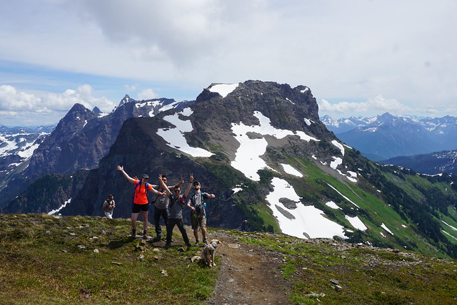
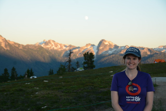
Given that this isn’t a crowded park, I thought it was a great option to visit with my husband, Seth, and our dog, Sadie, who doesn’t like other dogs. Seth and I went on holiday in late August this year and decided to do a shorter, 2-night trip around the Taylor Creek area. Technically, most of this trail is outside the park boundary, but it’s still in the same general area with the same kind of terrain. There’s a cut-out in the park where Eldorado Mountain is located (north of Tyaughton Lake, but south of Tyaugton Creek) – it’s called the Taylor Creek Basin, and that’s the area we decided to explore.
Similar to when I visited the park last summer, I spent the first day of my trip driving. It’s ~5 hours from Vancouver to Tyaughton Lake if you don’t hit any traffic, but we spent the better part of 8 hours getting there. The fastest way is to drive north out of North Vancouver to Pemberton and then take the Hurley FSR up to Gold Bridge. The Hurley is all gravel road, so it does slow you down, but was speedy in Brandon’s 4Runner last year. Alternatively, you can take Highway 99 to Lillooet, followed by Carpenter Lake Road. Carpenter Lake Road is also gravel, but in better condition than the Hurley. The last option is to drive to Lillooet via Highway 1 and Highway 12. I think this is probably the least popular option, but on the day we left, there was a major accident on the bridge to North Van, followed by slowdowns on Highway 99. Because I live in Coquitlam, the fastest route was to go via Highway 1, so that’s what we did.


It did seem like a particularly long drive, but I’ve never driven Highway 1 past Lytton, so it was exciting for us to try a new route. It’s a pretty drive and we did most of the route to Lillooet with minimal stops. We had supper at Lillooet Brewery, since it was the only dog-friendly place in town, and it has the Sowilo food truck on site. It was a great choice because the views from the patio are fantastic, and the food truck does delicious vegan bowls. I’d definitely recommend!
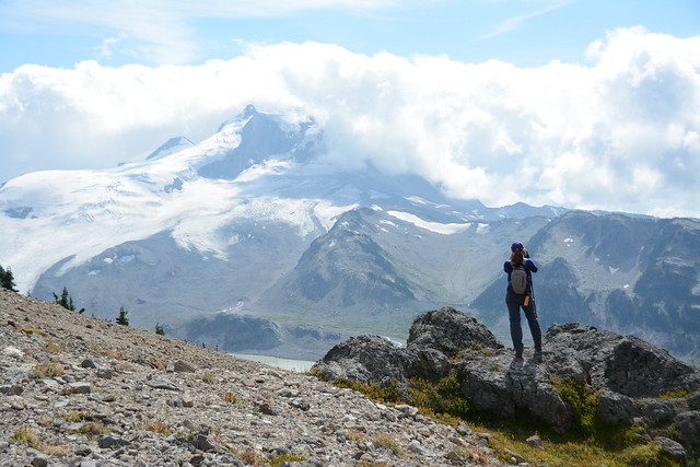
But we still had the final part of our journey, which involved driving Bridge River Road onto Carpenter Lake Road. I don’t think this is a popular drive and is a mix of old asphalt and gravel roads, but it should be more popular because it is breathtakingly stunning! It’s way faster to drive on the Hurley, but Carpenter Lake Road drives through a narrow canyon to the dam at the end of Carpenter Lake (see first photo) and I was in awe during the entire drive. Once you pass the dam, you drive along the lakeside for a long time. It’s strange because you expect such a beautiful lake to revolve around recreation, but there’s really nothing happening and no rec sites until you get to the end. We did the drive around sunset, so we had beautiful views of the lake and saw a lot of deer (so watch your speed). We spent the night camping at Mowson Lake Rec Site so that we could get an early start on the trail the following morning.


The biggest challenge we had on this trip was the weather forecast. After a mild summer, with minimal forest fires, we were heading into a heat wave during the last week of August. Seth doesn’t handle the heat very well, so we knew we’d have to focus on early mornings to avoid hiking in the middle of the day. We were up and away to the trailhead before the rest of the Rec Site had woken up in the morning.
Like I said, our plan was to explore around the Taylor Basin area. Seth prefers day hiking to backpacking, so we wanted to camp in the same spot for two nights, doing a day hike on our middle day. Chilcotin is a pretty rustic area. It does have designated campsites in some parts of the park, with outhouses and bear caches, but wild camping is also permitted. There are some areas (like Siwash Meadows) where people wild camp repeatedly, and other areas where people just random camp. There’s an old cabin located just next to Taylor Creek, below Taylor Mountain, where people will often wild camp. The cabin itself is completely dilapidated, so you can’t camp in it, but it’s a nice area. Our plan was to camp for 2 nights next to the cabin, or potentially wild camp somewhere in the alpine nearby.

We decided to park on Tyaughton Lake Road and do a loop trail to the cabin and back. There’s a road junction near North Cinnabar Creek and that’s where we parked the car. The first part of our day was hiking up another gravel road that eventually transitioned to trail. I think this was probably an old logging road at some point, but now it’s a nice, forested trail with a gentle incline. We had to hike uphill for ~12km, covering 750m of elevation gain. The trail is never too steep and it’s mostly forested, so it was nice to spend the day hiking in the shade. Seth and Sadie both liked it as there were a lot of blueberries and huckleberries on the trail, so we were able to stop frequently for snacks. We were very cognizant of bear safety (there are grizzlies in the park), so we kept Sadie on leash all day and made lots of noise.


The trail mostly follows Taylor Creek and around the 6km mark, you have to cross the creek. It looks like there was a bridge at one point, but it’s been washed out, so we had to ford the river. Fortunately, it was an easy crossing, but pretty cold. It didn’t stop Seth from doing a quick dunk to escape the heat! After that the trail gets a bit steeper and we stopped a few times for lunch and a break. We got to Taylor Cabin in the early afternoon, and we were the only people there. There’s no outhouse or bear cache, but it’s still mostly in the trees, so there is shade.
At some point before the trip, I got it in my head that I wanted to camp in the alpine (rather then at the cabin). I knew the weather would be clear and that it wouldn’t be windy, so I was keen to do a bit of stargazing. But I was very concerned about having access to shade. We decided to spend a few hours relaxing in the shade at the Taylor Creek Cabin, but ultimately ended up hiking another ~1.5km along the trail to look for somewhere to camp with a better view. I think I pushed Seth too far on this part because it was still very hot and it was a major slog to get up to the alpine.

Once you arrive, it’s not that simple to find somewhere to camp. There are limited water sources and despite it being very barren, there’s not that many flat places to camp. You want to avoid camping on any meadows or flowers and stick to bare rock or gravel, so it can be a challenge to find somewhere that’s flat, bare, and near a creek.
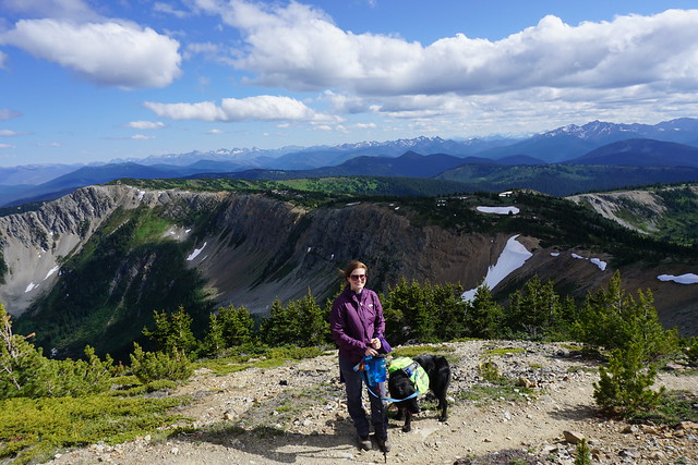
We identified a few potential locations, but none of them were great. There is a decent-sized creek that we thought would be perfect, but once we got close to it, we realized it was incredibly silty. Eventually we found spot next to a very small clear-flowing creek – it wasn’t ideal, but there were a handful of trees around to provide some shade, and we found a bare spot where we could avoid damaging any wildflowers. We had a few marmot neighbours located further upslope and they were pretty vocal in their dislike of Sadie. We kept her under control so that she couldn’t bother them and they eventually ignored us.


Seth was a bit annoyed about the extra mileage, but once we got settled, everyone was happy with the location. It was nestled under Taylor Mountain, south of Camel Pass, and we had a beautiful view as the mountain turned orange at sunset. We set up our camp kitchen very far away from our tent so as not to leave food smells on it while cooking, and we dug catholes further from the trail. We’d seen two mountain bikers when we started our hike in the early morning, but we hadn’t seen a single other person since then. It was one of the most remote places I’ve ever camped, and I felt very aware of the fact that we were truly in the wilderness. We had a nice supper and then spent time securing our food from bears.


For this trip, Seth and I each used a bear bag. A bear vault would be ideal, but all we had were bear bags, so we each bagged our food in dry bags to contain the smell and then put the dry bag in the bear bag. We couldn’t hang the bags, so we tied each bear bag to a tree, apart from each other. I don’t mean we just looped a rope to the tree, I mean we held the bag up to the trunk and wrapped the rope around the entire tree trunk and bear bag multiple times to secure it to the tree. We didn’t want a bear to walk off with the bag or make it too easy to get it off the tree. Fortunately, no bears came along to test it.
It was a beautiful night, and I did do a little bit of stargazing. I really wanted to do astrophotography with Taylor Mountain, but the milky way was on the opposite side of the sky from the mountain, and the moon was quite bright. I didn’t get any nice photos, but I did enjoy watching for shooting stars.


In the morning, we got up early again to try and beat the heat. It still found us mid-way through breakfast, but the air temperature stayed cool for a bit longer. The challenging thing about South Chilcotin is that the park is very exposed. We had the benefit of the shade from the trees the previous day, but we were going to be in the sun for most of the next two days. Our plan for the day was to take the Pearson Trail over to the Taylor Creek Trail, so that we could hike the High Trail up to Windy Pass for lunch. If you continue on the High Trail for a little bit longer, you end up at the base of Spruce Lake, which is the circuit I did last year, so I didn’t have any overlapping of trails, but sort of felt like I was connecting the two trips.
You can find a few places to wild camp along the Pearson Trail too, but they’re not any more ideal than where we were already camped (and a bit more exposed overall). But it’s a beautiful area! Pearson Trail hikes up to a little Pass, which I’m not sure of the name, and then you start hiking down the Taylor Creek Trail, parallel to Harris Ridge. Harris Ridge doesn’t have a trail, but people do like to hike along it. I was curious to explore it but given that it’s not a marked or named trail, I figured it was better to stick with the named trail, since I haven’t actually done either.


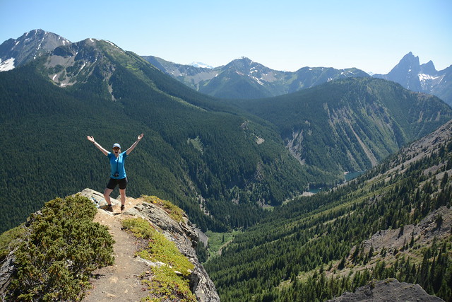
The Taylor Creek Trail goes in and out of the woods, providing beautiful views of Harris Ridge, and eventually of the meadows along the High Trail. Given that it was early and we were going downhill through the trees, that park of the hike was enjoyable. Eventually you hit a trail junction for High Trail, which is the official start of South Chilcotin Park. You can hike down through the Meadows towards Eldorado Cabin, or you can hike up towards the alpine and Windy Pass. This part of the trail is a steady uphill and it is exposed the entire way. I didn’t find it too bad because it was still morning, but Seth struggled with the heat and uphill. We were really hoping that “Windy Pass” would live up to its name, but it was only lightly breezy at best. All the trail blogs I’d read mentioned that it is usually quite windy up there, so I guess we just had bad luck.


The trail to Windy Pass reminded me a lot of the Lorna Pass Trail. We did it last year and it’s all exposed, but instead of being completely barren rock, there are lots of green patches and wildflowers around. I loved Lorna Pass and I loved Windy Pass too. It’s challenging because it’s all uphill, but I think I get an adrenaline boost hiking in the alpine meadows because they’re so beautiful, so I never remember the painful part! Sadie seemed to enjoy it too, though we were careful to keep her hydrated. The were a few creeks along the way, so it was possible to fill up our water when needed, but overall the creeks shown on the map aren’t reliable and are often dry, so don’t assume you will be able to fill up along the way.
We didn’t see any people all morning. When you get to the top of the pass, you do need to hike a little bit further if you want to get the view of the park. From the top of the pass, you can only see back down the High Trail, you need to continue to the viewpoint if you want to be able to see the rest of the park. I liked the viewpoint a lot because we were looking out towards the route that I’d done last year and I could see the Castles, which is another trail route in the northern part of the park that I have yet to visit. We encountered 1 couple on our way to the viewpoint that had hiked up from Spruce Lake and were heading back towards Gun Creek on the Lick Creek Trail. We had a nice conversation, and they were the last people we saw on the trip. So, over the course of our entire trip (3 days), we saw 2 groups (4 people). 2 backpackers and 2 bikers.


We found a single tree providing shade at the viewpoint and ended up hanging out for an hour. I’d been keen to do a bit more ridge hiking up from Windy Pass on the way back, but it was not in the cards for Seth and given the heat, I had to agree that it wasn’t a good idea. Instead, we went back the way we’d come and ended up clocking 12.5km and 550m of elevation on my GPS for the day. I enjoyed the hike back down Windy Pass, which had a nice headwind to cool us down. But it was a slog to hike back up the other side to the pass at Taylor Creek. Sadie was slowing down, so I ended up carrying her backpack. We crawled our way up the pass, taking another break in the shade along the way.
Eventually we made it back to our tent. It was still in the sun as it only got shade in the evenings, but we were able to hide among some of the trees to get a bit of shelter while we both took creek baths. While relaxing, I noticed that we could see a herd of ~8 mountain goats exploring around the side of Taylor Peak. They climbed around the mountain side, eventually making their way up to the meadows on top of the mountain. We were able to watch them all night, and they eventually returned to the mountainside to bed down for the night. We enjoyed a very chill evening, and I made an apple crisp for dessert before heading to bed. Tune back in next week for part 2!