If you’ve been following along, this is Part 3 of my Bowron Circuit series. Check out Part 1 and Part 2.
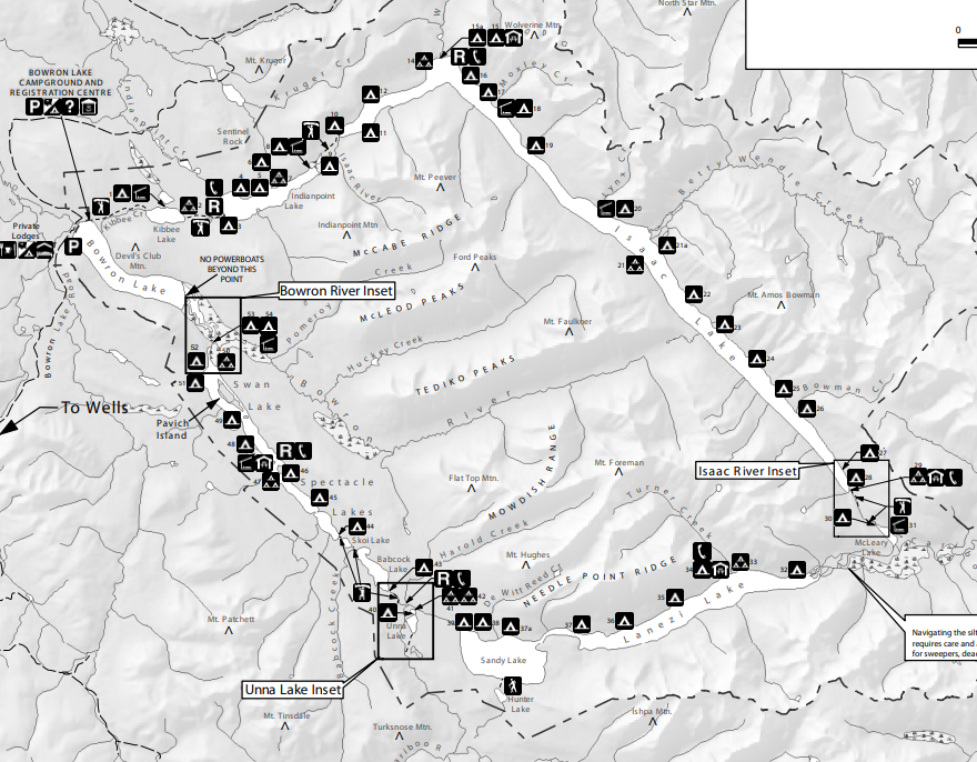
We left off at the end of Day 3, camping at Camp #28 next to the most notorious feature on the Bowron Lake Circuit: The Chute. The Chute is a section of standing waves where the end of Isaac Lake meets the mouth of the Isaac River. The main characteristics of the Chute is that there is a circular eddy on either side of the chute and a sharp right bend in the river at the end of it. If I’m being honest, it’s not that challenging, the trick is not to exit the chute too early. You want to get as close to the end of the waves as possible because if you turn too early, you can get sucked into the eddy, which will turn your boat sideways and then the waves will quickly flip you over.
I’m not sure how the water level contributes to the difficulty of the Chute. It was still Spring when we visited the park, so the water level was really high. One of the kayakers shared that he had done the Chute in the middle of summer when the water level was a lot lower. I imagine the waves are probably more pronounced in the Spring, but in the Summer, you have to worry about not hitting rocks, so it might actually be easier with the high flow.

The biggest challenge we had was that it was very cold. We were lucky to wake up and find the sun shining, which definitely helped, but the temperature hovered pretty close to zero degrees most mornings (one morning we woke up with frost on the boats). The risk of a capsize was a lot scarier at this time of year because of the cold water and air temperatures. In the middle of summer, you’d generally only be worried about losing your gear to the river rather than being concerned about hypothermia from getting dunked in it.
For this reason, more than half of the 5 Guys decided not to run the Chute. Three of them portaged around it, but two decided to paddle it, so Seth and I got to watch them before attempting it ourselves. They navigated the water without any issue, so we decided to follow close behind. I definitely think you have a bit of an advantage doing the Chute in a kayak because you’re not really worried about losing gear. Everything is enclosed in our hatches, so we only had to deal with the cold. The Canoe Bros also ran the Chute, but they spent more time to bungee all their gear to the canoe, so they went after us.


The other advantage me and Seth had is that we were wearing wetsuits. Generally, a dry suit is much better, but they’re also very expensive, so we’ve managed just fine with our wetsuits for years. I still didn’t want to get dunked, but at least I had 3mm of neoprene between me and the cold water. We decided that I would paddle the Chute first so that Seth could assist me if I capsized. Fortunately, we both made it through the Chute without incident! And you know what, it was so much fun! We’re not experienced paddlers by a long shot, but I definitely think that if you can handle paddling 116km of wilderness, you can handle the Chute and I’d encourage people to give it a try. Take the time to plot out your route first and discuss risk management and what you will do if you capsize. Secure your gear if possible to minimize the impacts of capsize, but overall, I think the Chute is a pretty manageable objective and I was so glad that we took it on.
Although, the Chute is only the start of the adventure! Once you run the Chute, you are committed to another 1km of paddling along the fast moving river. The next section of rapids are called the rollercoaster, but they’re mostly just sections of standing waves. It’s not a big deal to go through them, you want to make sure you avoid any rocks in the river, so it’s mostly an exercise in looking for hazards. I suspect this part of the river is a bit easier in the Spring when water levels are high because there are less obstacles.

The river paddle goes by very quickly and then there’s a mandatory portage around a section of the river known as the Cascades. The portage is only 800m and it is all downhill, but the trail is in rough shape and there were a lot of tree roots and rocks that we had to go around. Then there’s another short section of paddling in the river (~600m). At this time of year, the river is moving really fast and there are some more sections of standing waves, so I found it fun to paddle.
However, you have to be careful not to miss the sign for the last portage, because if you go too far downstream, the next water feature is Isaac Falls! The signage is pretty obvious and we pulled our boats ashore for another 500m portage. Once you finish that portage, the bulk of the portaging for the circuit is done. You launch back into the river, but are quickly pushed out into McLeary Lake.


McLeary Lake is one of the smaller lakes on the circuit, but it is really beautiful. There’s only one campsite on it and I don’t think it’s super popular because most people stay overnight at the top of the Chute, but I think this one would be really nice if you wanted to do the Chute later in the day. McLeary Lake felt like one of the most remote lakes to me. I think it’s because it’s shallow and it felt more like a river delta. It’s a quick paddle across the lake, which connects the Isaac River to the Cariboo River, so we pulled our boats up on the sandy shore for a break before taking on the Cariboo. It really felt like we were in the middle of nowhere and I could envision seeing a moose or a caribou at any moment.
We still had to navigate the Cariboo River, which is probably the second most challenging part of the circuit, after the Chute. You can’t portage around the river, so what makes it tricky is that it’s 6km long and there are lots of hazards lurking along the shore or just under the surface. You need to be careful to watch for deadhead (debris under/in the water) and sweepers (debris across the river) that could knock you from your boat. I’m not sure what the current is like in the summer, but in the spring, there was a lot of water and it was moving very fast. I felt that capsizing in the Cariboo River would be more dangerous than the Chute because the current moves so fast, it’s really important not to get separated from your boat.


Fortunately, everything went smoothly for us and it was probably one of the most fun and beautiful sections of the entire circuit. Combined with running the Chute, Day 4 was easily our favourite day of the trip. Because the current was moving so fast, we barely had to paddle at all and we were surrounded by the most scenic and remote mountain landscapes. My jaw was on the floor of the boat the entire time! I think we had less hazards to worry about with the water being so high, but there was one large tree submerged below the surface in one section that played with my imagination because it would be quite easy to capsize if you got too close or didn’t see it.
We had planned for a shorter day because I was worried about the Chute and the Cariboo River, but because those sections of the river are fast moving, this actually would be a good day to knock out some serious mileage if you were behind schedule. 5 Guys and the Canoe Bros were all aiming to make it to Unna Lake, which was a lofty 35km of paddling. Our goal was Turner Creek (Campsite #34), which was only 15km, and we decided to check it out before choosing if we wanted to paddle further.


We ended up paddling all the way to Turner Creek for a late lunch before stopping. Once you exit the Cariboo River, you’re at the bottom of the circuit, starting with Lanezi Lake. I’d heard the south end of the circuit was particularly stunning and I didn’t want to rush through it. The wind picked up pretty much right away when we got to Lanezi Lake, so it was a bit of a work-out to get to Turner Creek, which is a few kilometres up the lake. We ended up arriving shortly after 1pm. It felt a bit early to stop, but it got a bit stormy when we landed on the beach and started to rain, so we quickly ran up the camp to the shelter.
The shelters early on the circuit are more like little ranger cabins. They’re not very big and seem to be historic to the park. On the second half of the circuit, the shelters are modern construction and clearly designed to accommodate more people. The shelter at Turner Creek was the same as at the Chute, but this one had windows, which is much more practical if you want to use the woodstove. As soon as we got to the shelter and saw the views from the campsite, it was a very easy decision to stay and have a lazy afternoon. We watched as 5 Guys and the Canoe Bros all paddled past us on their way to Unna Lake.


Turner Creek is a large site and I think it’s pretty popular in the summer, so it’s hard to believe we had it all to ourselves! We picked a campsite with a gorgeous view of the lake, with the fire pit right on the edge of the site overlooking the view. Seth got a fire going in the woodstove and we unloaded the boats and changed into dry clothes. The rain was short lived and after a few hours of wind and waves, the sun came out in the late afternoon and the water got really calm. I mostly just read and soaked in the sun for a few hours, which was much needed! Seth opted to go for a quick swim, but I was still too chilled for the water, so I just enjoyed the view.
At this point of the trip, we hadn’t seen a lot of the other paddlers who started with us. There was a group of New Brunswickers who paddled faster than the rest of us and we didn’t see them after the second day. But there was also a solo kayaker who was doing the circuit with a 10 foot sit-upon kayak. We talked to him briefly on day 1 (he shared that his kayak felt very “tippy”) and then we hadn’t seen him since. I have mixed feelings about the appropriateness of this kind of kayak. Really, they are not appropriate. 10 feet is very short for this kind of trip and sit-upons lack the stability of an ocean kayak. I can’t imagine it felt very comfortable in the challenging conditions of Isaac Lake. But on Day 4, the solo kayaker eventually caught up with us and he did end up finishing the circuit, so I guess I don’t have any right to judge him. I would not recommend it, but I guess it can be done. He pulled into another site for the night, so we still didn’t get to talk to him.


We spent the rest of the evening eating and enjoying the view. I made supper and Sseth got a campfire going looking out over the lake. The weather really cleared up and we didn’t get any more rain that day. Instead we just enjoyed the solitude of the site before eventually going to bed for the night. This was the only night on circuit that I was a bit cold overnight. We packed really warm sleeping equipment, but the next morning when we woke up there was frost on the kayaks, so it obviously got pretty cold overnight!
On Day 5, we finally got a morning where the lake was dead flat in the morning and we were super excited to launch the kayaks! The sun was still hanging around and we had a really enjoyable paddle along the edge of Lanezi Lake. The mountains on the south side of Lanezi are super picturesque. There’s a few small campsites along the edge of the lake and as we were approaching one for a snack break, Seth spotted a marmot along the lakeshore! It didn’t seem like marmot habitat, but I guess this guy found a good place to make his home between some loose rocks.


The weather was very temperamental, but not necessarily in a bad way. We could see the storms moving around throughout the day. You’d look one direction and it would be rainy and dark, and then you look the other direction and it’s blue sky and clouds. We weren’t immune from the rain, but the wind stayed low all day, so it didn’t bother us. We had another snack break at the end of Lanezi Lake, at Camp #37, which is a really beautiful site.
From there, you briefly return to the Cariboo River to paddle into Sandy Lake. The river is really wide in this section and it’s not fast flowing. Sandy Lake is small compared to some of the other lakes and we did get a spot of bad weather as we were paddling into it. But there are some really nice campsites! As the name suggests, there are sandy beaches along Sandy Lake and the campsites are very large, with lots of room for tents to spread out. We took a break for lunch just as the wind was coming up, but fortunately it was short lived and seemed to calm down again after we re-launched.

The last section we had to paddle for the day was to re-join the Cariboo River until we reached Unna Lake. Unna Lake is probably the most well known site on the circuit, so it has a lot of campsites and is very popular as a place to stay. To get there, we had to paddle 21km in total, which was pretty achievable 5 days into the trip and considering we had decent paddling conditions.
We weren’t sure what to expect from the Cariboo River in this section. We thought it might be fast moving like the section from the previous day, but it was more like a lazy river. We had to work a little bit more with the paddling, but we saw lots of birds along the way, especially kingfishers, which are my favourite bird!


Unna Lake is actually located off the circuit, so in order to get there, you have to paddle past the next portage to Babstock Lake, until you get to a little entrance off the river to the lake. The lake is pretty sheltered and I think it’s popular because it’s usually quite calm. There’s a huge beach with lots of campsites at Unna Lake, and if you paddle further into the lake, there’s a second lake called Rum Lake, which is where the group campsite is. The other attraction on the far end of Unna Lake is the trail to Cariboo Falls. There’s no hiking in the park except for this trail. It’s a 1km trail that hikes further along the river to the thundering Cariboo Falls.
We could see the Canoe Bros across the lake heading out towards the trail, but the campsite was empty so we assumed they were on the way out. Again, we had a very large and popular campsite all to ourselves, which felt a bit surreal! We picked a nice spot to set up and then the sun came out and I finally felt like I might be warm enough to go for a swim. There was no one around, so the only real option for swimming was skinny dipping. I can tell you, we never miss an opportunity for skinny dipping and given the low crowds on the trail, neither of us used our swimsuits on the trip 😉


I finally went for a swim and because Unna Lake is so shallow, it was surprisingly warm. It felt nice to wash my body, although we had been doing heated cloth baths throughout the week and those are pretty nice too! We figured there was no rush to hike to Cariboo Falls and decided to just relax along the beachfront instead. Unna Lake is very sandy, so I can understand why it’s so popular in the summer. That said, if you can’t make it all the way to Unna or it doesn’t work with your itinerary, I honestly think Sandy Lake is just as nice, and probably gets less people.
Later in the afternoon we got a little bit of entertainment. Once you hit Unna Lake, you’re on what is considered the West Circuit. If you don’t have enough time for the entire Circuit, you can plan a shorter itinerary on the West Circuit, which involves starting your paddle across Bowron Lake in the opposite direction. You’re permitted to paddle as far as Unna Lake, after which you have to turn around and paddle back to Bowron (because of the currents on the Cariboo River). So generally, the circuit did feel a little bit busier after Unna Lake and it was harder to guess how many people might be interested in the same campsite.


As we were relaxing, a very large school group with about a dozen canoes entered the lake. They were all on the west circuit and staying at the group campsite on Rum Lake for the evening. It was at this point, when we saw the Canoe Bros starting the paddle back, that we realized they had actually been camping at Rum Lake overnight and had been planning to stay a second night. They had to pack up all their gear to vacate the group site and then they opted to paddle on to Babstock Lake instead. So we still ended up being the only people at the Unna Lake campsite for the evening.
We planned to eat supper and then go to the Cariboo Falls trail in the evening, but around 6pm it got super windy! Unna Lake was the only campsite we ended up staying at that didn’t have a shelter, so I made a nice little tarp shelter with our paddles and the wind really put it to the test. It’s only a 10 minute paddle across the lake, but we decided to wait until morning with the wind being so high. We had planned to have a campfire, but I ended up getting chilled by the wind and decided to have a lazy night in the tent instead. I did a bit of reading and went to bed super early, but the exhaustion really catches up with you on these types of trips and I think it was much needed. Check back next week for Part 4!