ECT Series: Cobblers Path

Cobbler’s Path was one of the first sections of the East Coast Trail I ever did and I kind of forgot about it in my zeal to hike new sections I hadn’t done yet. However, I’m so glad I returned to this trail over the holidays because I remembered very little of it and it’s such a great trail! Cobblers Path is only 5km long and runs from Red Cliff to Outer Cove. There’s a bit of climbing on the Outer Cove side of the trail, but overall, it’s a pretty easy trail that is extremely close to St. John’s.

20211230_114158

My friends Philippa and Justin are avid hikers as well and convinced me and Sean to join them for a hike at the tail end of December. We all met at the parking lot in Red Cliff and started from there. The trailhead has changed in recent years as the area has developed – the old parking lot on Red Cliff Road has been replaced with a new one at Cobblers Crescent. You hike up through the trees from the parking lot to connect with the coastal trail. You can turn right to go down to “Logy Bay Viewpoint”, but it’s a dead-end because one of the crotchety old land owners won’t let the trail pass over the edge of their land, so the association haven’t been able to connect through to the Ocean Sciences Centre and Sugarloaf Path.

received_242633654665921

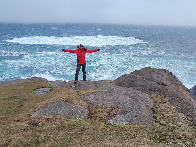
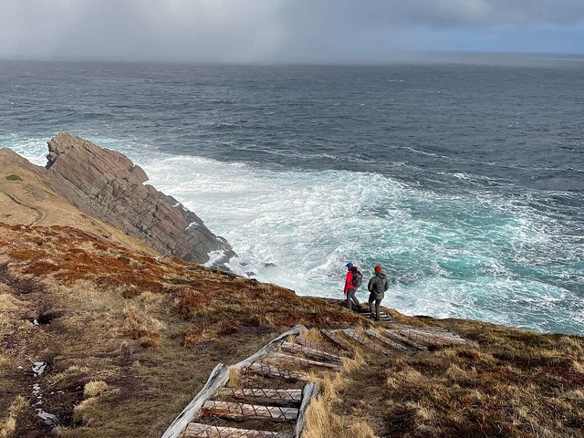
We opted to just continue on towards Outer Cove. It was a classic Newfoundland weather day when we hiked and we got every season in one day. It was pretty cold when we started and there was a bit of snow down on the trail. We opted to wear studs because it was pretty slippery, but most of the covered tree sections didn’t have any snow. It was overcast when we started and we caught glimpses of blue sky overhead as the day progressed. The trail passes by some old graffitied buildings and there is another lookout bunker at Red Cliff that dates back to the war (same as on Sugarloaf and many other sections of the trail). At the same location there’s an excellent view back towards Logy Bay and we had a bit of a photoshoot.

DSC00033

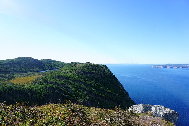
I have to say, I do think the cliffs on Cobblers Path are some of the most iconic on the East Coast Trail. That might sound a bit random, but I say it because they are visible from so many other sections of the trail. Even though I hadn’t done the trail in about 10 years, I can always identify it from other parts of the trail. The cliff-side has a sharp diagonal slope in this section and the stratigraphy of the rock looks almost perpendicular to the ocean.

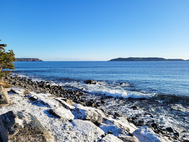
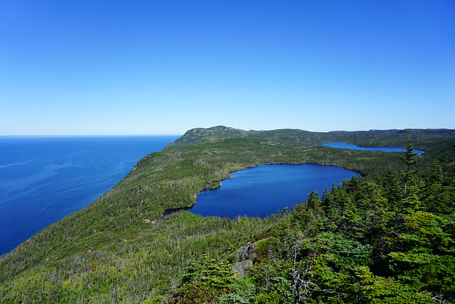
After Red Cliff, the trail descends towards Shooting Point Cove and Cobblers Brook – this was the only other part of the trail I could remember from my first visit and I swore it was my favourite section of Cobblers Path. You climb down through the forest and then cross a bit of a meadow area before starting to hike back up towards Outer Cove. On this day, it was really windy and the ocean was looking extremely unforgiving. The waves were crashing up onto the rocks and there was so much wind that it was blowing all of the salt water spray up onto the trail. A little cold, but a beautiful section of coastline.

20211230_114409

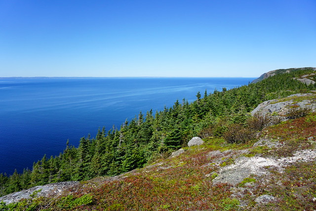
I would say the section after Shooting Point Cove is the only challenging part of the trail. You immediately start hiking back up through the trees and it’s a bit of a climb until you poke out at the first viewpoint of Torbay Point. The clouds were breaking up more at this point and there was quite a bit of blue sky overhead, so we crossed our fingers that the sun would come out.

20211230_122601

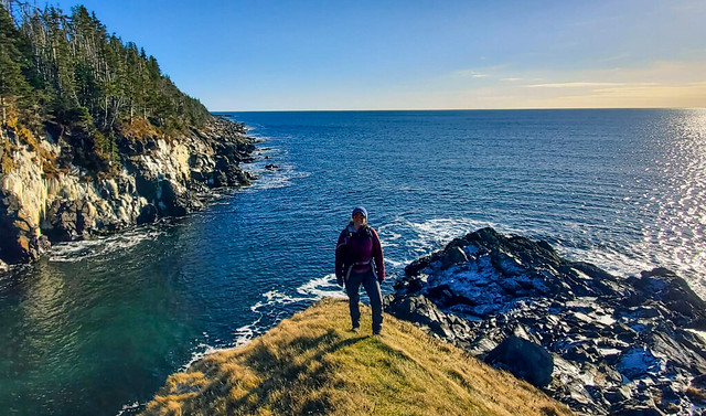
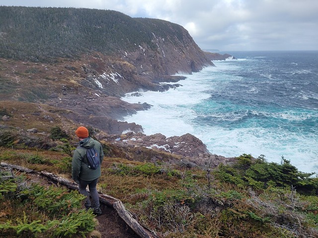
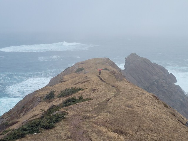
I thought Shooting Point Cove was my favourite part of the trail, but I must have skipped Torbay Point on my first visit because that quickly replaced Shooting Point as my favourite and I’m sure I would have remembered it. Philippa and Justin didn’t have time to go down the point because they had a scheduled pick-up, but me and Sean had lots of time to kill, so we said goodbye and hurried down the trail.

received_1000275493857678

“Hurry” is the key word here because the weather was quickly changing again and despite the recent blue sky, we could see a lot of clouds moving in towards the point. I wanted to get some photos at the end of the point and as I ran down towards it, the wind was so strong it literally brought tears to my eyes and I had to shield my face. We got our shots and then started back up towards the main trail as the clouds blew sideways sleet at us. The weather had majorly deteriorated in a matter of 10 minutes and we hid behind some rocks at the trail junction for shelter. We were pretty hungry (or at least I was) and wanted to eat my lunch before we finished the trail.

20211230_124608(0)

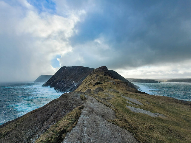
In the time it took me to eat my sandwich, the clouds moved down the coast and the sun finally broke through and completely transformed the landscape. It burned off the rest of the clouds in a matter of minutes and I cursed that I now wanted to take all the same photos again in the improved conditions. I held off though because I did quite like the moody cloudy ones we’d already taken and just snapped a few photos of the sun drenched cliffs instead.

PSX_20220103_162933

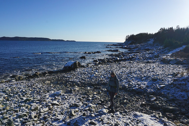
It’s only a short walk out from Torbay Point and Philippa mentioned they visit every year just to hike out to the point – so it’s a great alternative if you’re just looking for a short jaunt with epic views. The trail pops back out on Doran’s Lane, which is filled with more crotchety homeowners, so be careful where you park. In the summer you can park on the right side of Doran’s Lane (not the left), but in the winter there’s no parking on either side due to snow clearing. Personally I think this is a bit bogus, but the town asks you park down at Outer Cove Beach instead.

PSX_20220102_233935

In our case, Sean’s family lives in Outer Cove, so we just hoofed it a few extra kilometres to his house and then returned to pick up my car from there. If you don’t want to bring 2 cars or do a return trip, you can also hike back along the highway – it’s quicker that hiking 5k back along the trail, but there’s not much for sidewalks so be cautious. To conclude, I’m thrilled I took the time to return to this trail, it was so much more scenic than I remembered and makes for such a great hike only minutes from my parent’s house! Definitely recommend.

20211230_125143

ECT Series: Beaches Path

2021 was my first Christmas home in Newfoundland since 2018, so I had lots of plans for my visit. Unfortunately they were, of course, all dashed by Omicron, but I still got to spend time with my immediate family and fortunately, the outdoors is always open, so I managed to do a little bit of hiking.

There was some snow when I visited, but pretty much nothing had accumulated yet. I brought my microspikes with me to do some hiking along the ECT, but they were overkill and I ended up just using my mom’s studs. The trail had the lightest dusting of snow and ice, but on the sunny day I hiked there, it made for the most picturesque photos!

PSX_20211224_150351

Beaches is a 7 kilometre trail between Witless Bay and Mobile that is ranked as easy. I only tracked 50metres of elevation gain over the whole thing and it was definitely a nice and simple trail. I went with my mom and it took us about 2.5 hours to hike one way. We started in Witless Bay and arranged to get picked up in Mobile. It’s nice to only have to hike one way, but given the ease of trail and distance, you could hike there and back if you don’t mind committing ~5 hours to the trail.

20211222_104310

I really liked this section of the East Coast Trail. In addition to being an easier trail, it’s incredibly scenic! it was a beautiful blue sky day when we visited and the first half of the trail out of Witless Bay takes you along several different beaches and along a few bluffs and cliff-sides. There are small sections through the woods, but for the most part you are directly along the coastline. The second half of the trail is a bit less scenic and has longer wooded sections, but there is one really nice viewpoint at Herring Cove that is worth walking down to. We still liked the entire trail, but if you only have 1 vehicle and don’t want to hike a full 14km, I would recommend hiking halfway along the Witless Bay side of the trail instead.

PSX_20211222_165918

This entire trail looks out towards the Witless Bay Ecological Reserve. From the Witless Bay side of the trail there’s a nice view of Gull Island (see if you can spot the researchers cabin, Seth has done research here in the past!) and we could see a few puffins flying around from the Mobile side, even though it was winter. I haven’t hiked this trail in the summer, but I suspect there should be good bird-watching and whale-watching along the trail when it’s warmer. If not, it’s totally worth taking a boat tour of the area with either O’Brien’s or Gatheralls. We also spotted a seal hanging out in the water around the halfway point of the trail. This is a common occurrence in Vancouver, but I’ve never seen a seal from shore (and rarely from boat) in Newfoundland, so it was an exciting occasion!

DSC00007

Overall, Beaches Path makes for a great day hike. It’s a good length and the drive from St. John’s is reasonable (~45 minutes). It’s a very scenic trail, particularly on the Witless Bay side and I would love to return on a warm summer day. If you decide to do in the off season, I just recommend bringing some kind of traction (spikes or studs) if there’s any snow or ice down on the trail.

PSX_20211227_003100

ECT Series: Piccos Ridge

Piccos Ridge is the most recent section I’ve done on the East Coast Trail. It runs from Portugal Cove to Bauline on the west side of the northern Avalon Peninsula. The trail has been around for many years, but it is one of the newer trails and the ECT association has been doing trail expansion on the northern side of Bauline Line recently as well.

At 14.5km, Piccos Ridge is one of the longer trail sections and it has a bit of a reputation of being one of the more challenging trails due to the steep uphill at both ends of the trail (and throughout). Emily hates this section and when I was out for dinner in July with my family, my cousin started bragging about how he had done Piccos Ridge and therefore could pretty much do any other trail. I was skeptical that Piccos Ridge was the pinnacle of Newfoundland’s challenging hikes, so I figured I’d bump it up my bucket list. I ended up having to make a surprise trip home again in September and decided to give the trail a try to see if it lived up to my cousin’s assessment.

DSC00702

I will admit, Piccos Ridge is harder than some of the other trails of similar length, such as Stiles Cove. I didn’t find it as challenging as some of the other sections I’ve done (the Spout kicked my ass), and I’ve definitely done more strenuous mountain climbs in BC, but I can definitely see where it gets its reputation. It is very steep climbing up the trail out of Bauline and there is a fair bit of undulation across the rest of the trail, so it feels like a lot of climbing throughout. I read a few reviews on AllTrails before going and they all strongly recommended starting the trail in Portugal Cove and going north because the last stretch into Bauline “was very difficult to even climb down it”. Friends, can I let you in on a secret? It is so much safer to go up steep sections than down. Also, I have bad knees and I prefer going up over going down, so I decided to buck the trend and start my hike in Bauline.

DSC00718

It took me about an hour to get from Bauline to the first lookout. That is the most strenuous part of the hike, so I was glad to get it over with early and it got much easier after that. I went on this hike solo and it was interesting because I hiked shortly after Hurricane Larry had passed through Newfoundland, so there was a lot of blowdown along the trail. I debated a few times if I was maybe getting myself into trouble climbing over the trees and would potentially get stuck somewhere further along the trail, but the first section was the worst and I didn’t encounter too much more downfall after that.

DSC00722

From the first lookout, you hike back down a little bit before ascending up to Piccos Ridge, which is the highest point along the trail. Even though it was getting later in September, I encountered quite a few berries in this section, particularly partridgeberries! You continue along the ridge for awhile before making a big decent through the trees towards several ponds. There is an unofficial campsite located at Brock’s Head Pond at about the 8.5km mark. I could only see room for 1 or 2 tents in the trees, but there is a bit more open space just past the pond at the river, which is the water source. There are no facilities.

DSC00738

There’s one last uphill climb after the campsite, but then it’s smooth sailing after that! I think this was my favourite section of the hike because it’s all wide open and barren at the top. Piccos Ridge has a lot of different viewpoints, but large parts of the trail are in the trees, so I love hiking along the barren rock with the Atlantic stretched out alongside you. The view from this trail is into Conception Bay, so on a clear day you can see over to the other side of the peninsula and there are great views of Bell Island.

DSC00748

The rest of the trail is a steady downhill, so I can see how it’s a strenuous trail from either end, though the uphill is more gradual on the Portugal Cove side, which is why most people prefer that direction. Unfortunately I didn’t end up making it quite to the end of the trail. A few things came up and I decided to get off the trail a little early to try and make another appointment. Shortly after the 12km mark (so 2km before the trailhead in Portugal Cove), there’s a branch that exits off to Blast Hole Pond Road. The very top section of the road is gated, but then it’s gravel road which turns to asphalt. My knees were really bothering me, so I figured this would be an easier and quicker exit along the road, which was definitely the case. Mom was going to pick me up at the top, but I ended up powering it down the entire road before she got there. So overall I did the same distance, but skipped the last 2km to the official trailhead.

DSC00709

I would definitely go back sometime and hike up from the Portugal Cove side just to get the views. The highest view on that end is at 4km, but there’s views along most of the trail here, so you could hike as far as you want and then turn around for a shorter hike. In total it took me 5 hours, but I didn’t stop very much and I would recommend more time if you’re in a group or want to pick some berries. I did really like this section of the trail though considering Emily has been bad-mouthing it to me for years. There’s some ECT sections I wouldn’t want to do twice, but this definitely isn’t one of them!

DSC00754