This may be the last post in my Manning Park mini-series for now. I have a few more trips I can write about, but they cover some of the same trails, so for now I’ll save them for another time. But I have a great trip to end off the series with – a 4 day trip I took in 2018 with Girl Guides of Canada.
I was a girl guide growing up in Newfoundland and I’ve been volunteering with the New Westminster District in BC for the last 5 years. I’m currently a leader with a pathfinder group, which is girls 12-14, so I wanted to expand my camping skills so that I could start to take girls on backcountry trips as well. There’s obviously a lot of risk involved in taking girls into the backcountry, so I completed an Outdoor Adventure Learning course and was selected to go on an adult backpacking trip to Cathedral Park.
The trip was scheduled for the BC day holiday in August – if you recall, 2018 was a SUPER bad summer for forest fires in BC. So I was really excited about going to Cathedral Parks, but unfortunately, there was a nearby fire and the park closed just days before our trip. It probably would have been easier to cancel the trip, but fortunately I was going with a group of enthusiastic women and we quickly came up with a back-up plan to go hiking in Manning instead.

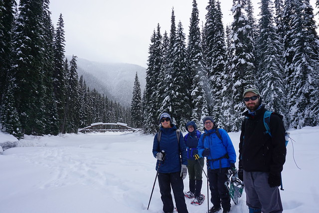
I’m sure everyone’s heard of the Pacific Crest Trail – it’s definitely a dream of mine to hike it some day. The trail actually ends in Manning Park, so it makes for a great long weekend hike for locals. 4 of us piled into one car in Vancouver to make the drive out to the park, where we met with 4 other women who would join us on the hike. The goal was to build our own skill sets and share knowledge so that we’d gain the ability and the confidence to take girls into the backcountry.
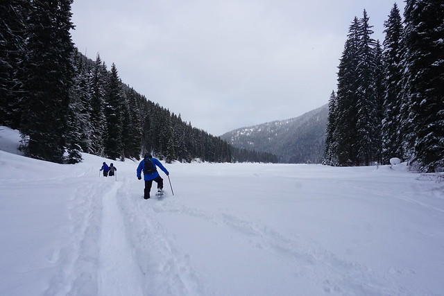
Our goal for Day 1 was to hike 7.5km to the final campsite on the PCT Trail (there’s 2 on the Canadian side of the border). We toyed with the idea of going up to the Windy Joe lookout, but ultimately decided against it. Our group consisted of hikers of all different abilities, so it was a good exercise in learning how to accommodate everyone’s skill set. Some of us do a lot of hiking and didn’t find the hike too challenging, while others struggled with their pack weight. Girl Guides definitely err on the side of caution, so we did go into the backcountry pretty heavily loaded. One of the participants dropped out at the last minute and another Guider was added to the trip, so she struggled on the trail because she didn’t have the time to train like the rest of us. About halfway to the camp, we re-distributed some of our gear to make it easier on those who were struggling, so I ended up with a pretty heavily loaded pack.

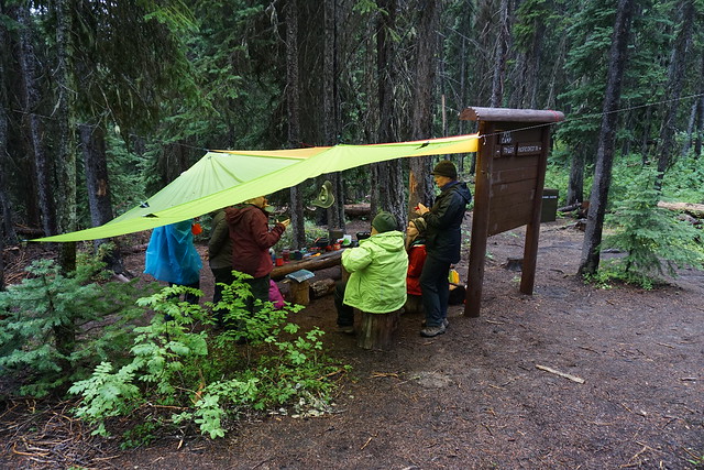
But we made it and found some sites to set up our tents and start making dinner! The campsite is pretty forested, but you can get a little bit of a view through the trees. It’s also not the largest campsite, so it can get pretty crowded, especially on a long weekend – which this was – but we took Friday off so we had a head start on the rest of the weekenders.
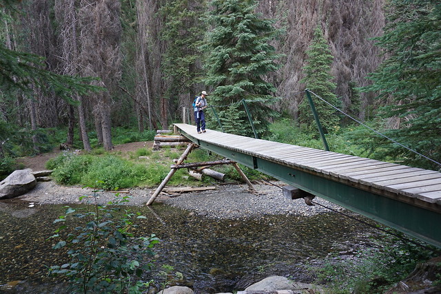
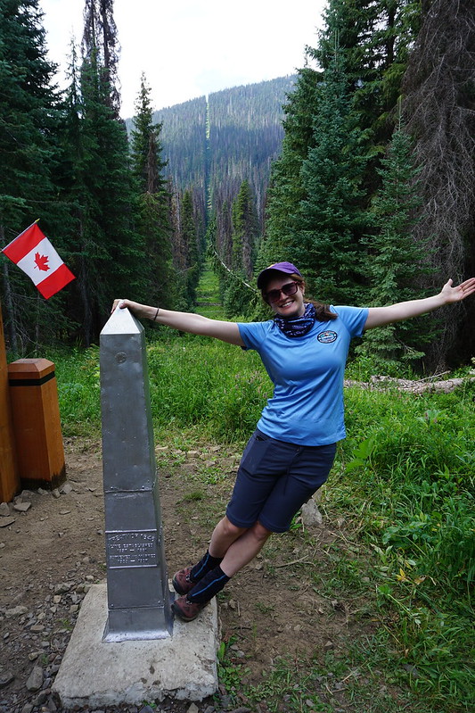
On day 2 we planned to continue on the PCT to border Monument 78, a popular photo spot for all the Northbound through-hikers (and I’m sure for the SOBO hikers too). It’s about 5km to the border monument – it’s not the most scenic trail, but it’s a steady downhill towards the 2nd camp, located just before the border. The camp is quite pretty, with this super clear river and a pretty rickety, but fun, bridge going over it.
We stopped to use the outhouses before walking the last 500 metres to the monument and I had a bit of a mishap. Right after I used the outhouse I was using my hand sanitizer and when I snapped the lid closed, it shot a big glob of hand sanitizer right into my eye! It burned so bad. I immediately screamed out, likely terrifying all of the other Guiders into thinking there was a bear, but quickly communicated I’d gotten hand sanitizer in my eye, which brought the first aider running. If you’re ever going to get injured in the wilderness – do it with a group of Guiders, they are the most prepared people in world.
Our first aider had me lying on the ground in no time while she poured a steady stream of water into my eye. It worked at flushing my eye out, but what surprised me what how long she had to do this. She flushed my eye for about 10 minutes before I felt I was okay to go on. We finished the walk to Monument 78, snapped some photos, and then she flushed it for another 5 minutes while the rest of the group walked back to the camp for lunch. After that it seemed we had flushed it enough and fortunately it didn’t bother me any further. The things that can happen to you in the backcountry are just so random!
We ate lunch next to the river and soaked our feet in the water. It was freezing, but it was a pretty hot day and it while it was a bit numbing, it was also refreshing. The rest of the hike was pretty uneventful. It was mostly uphill on the way back and since we had such varying abilities in the group, we decided to split in two. I went ahead back to the campsite. Some of us were toying with the idea of going back to do the Windy Joe lookout that we had skipped, but decided to wait for the rest of the group at camp first. We sat down for a few snacks and noticed that some pretty foreboding looking clouds were moving in. It started to look like it might rain, so we secured the camp, making sure everything was tucked away where it wouldn’t get wet.
The rest of the group showed up just before it started raining, which was lucky because once it started it was like the clouds just let loose and it started torrentially pouring on us. We had brought 2 tarps with us, so we quickly put them up to huddle under. This was my first time really getting caught in a mountain storm and it was another good lesson in always being prepared. I’ve been out hiking in the rain before, but it was amazing how this storm came out of nowhere. The rain switched to hail for a bit in the middle and we were relieved to have shelter. A few groups showed up while it was raining and they were just drenched to the skin. They started trying to put their tent up, but we advised them to wait it out rather than risk getting everything else wet. It was the right call because as fast as it started to rain, it let up and the dark clouds moved on. All in all it was probably about of hour of rain, but boy was it a lot of water. The sun came out soon after though and it was almost like the whole thing never happened.
On day 3 we decided to split the group in half from the start. About 100 metres before the campsite, the PCT branches off to Frosty Mountain. Frosty Mountain is a well known Manning hike, especially in the fall when the larch trees all turn golden yellow. It’s about a 20km hike to the top of Mount Frosty and back. You can do it as a loop or hike up either side of the mountain. I think most people start from the other side because it’s a shorter hike on that side, so if you go in and back you can save yourself a few kilometres. Plus there’s a camp on that side as well. But our goal for the day was to hike up to the summit and back to camp. At 18km round trip, it was a big hike for us and had a lot of elevation gain.
We got up early to get a start on the trail. It’s a steady uphill the whole way, but we made good progress, stopping only once on the way up for a snack. The first part of the hike was in the trees, but the higher you get the more it starts to open up. There’s some really beautiful mountainside meadows with views looking out over the park. Unfortunately the wildfires were really picking up steam and there was a fair amount of smoke blowing through. Not enough to obscure the view, but enough to make everything a little hazy.
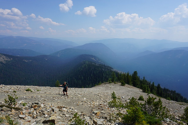
Eventually the trail opens up more and you hit a steep rocky section. Things got a bit more slow going after this. On the map it looks like you’ve done a lot of the trail, but the last section is the most challenging. We continued on up over the rocks, following a steady stream of switchbacks up the side of the mountain. A lot of it is boulder fields, so it’s pretty technical and sometimes hard to see where the trail goes. You can see a signpost that looks like the top most of the way up, so we just kept striving towards the sign.
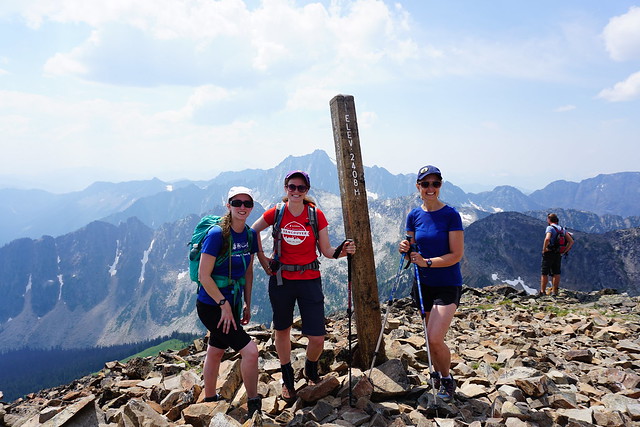
We finally made it, but unfortunately it’s just the point where the trail up both sides of the mountain meets. There’s still about another kilometre along the ridge to get to the peak. We had set a return time to meet back at the camp, so we were trying to keep a schedule that was starting to get tight, but none of us could resist going all the way to the top. We were pretty exhausted, but we pushed through along the ridge to the very peak.
It was totally worth it. Mount Frosty has unreal views of the surrounding mountains and the hike along the ridge is out of this world. From the top you have a 360 degree view all around. It’s totally the kind of viewpoint I live for. It was a nice day, as well as being a long weekend, so there were a lot of people around and we had to share the top with a bit of a crowd. It was really windy at the peak, so we decided to go about halfway back along the ridge to eat our lunch. We still had an amazing view looking out over the park as we ate.
We took about a half hour for lunch and then we definitely had to start heading back to make our return time. I know some people prefer downhill, but I really hate it. I don’t find it any easier, especially with how steep the rocky section was on the way back. Once we got to the meadows it was a little easier going, but by then we’d hiked a lot of kilometres with very few breaks and our legs were really starting to ache. We pushed through, rolling in to camp right at the pre-arranged time!
We enjoyed one last evening together. While the hiking was mostly what I focused this blog on, it was really only one small part of the weekend. The rest of the trip was about supporting each other and being a part of a Guiding team. There were 8 of us, so there was a lot of planning and coordinating involved in the trip. We divided ourselves across 3 tents and ate all our meals together. Everyone was responsible for planning 1 meal for 8 people. I quickly signed up for breakfast because it’s my favourite meal, and in my opinion the easiest, but apparently everyone else was a fan of dinner, so I had some really great meals on the trip. One of the Guiders brought an outback oven – it’s a piece of camping equipment that has been discontinued by the manufacturer but is dearly beloved to almost every Guider I know. So for one of our mug-ups she made us an actual chocolate cake! Still the one and only time I’ve had homemade cake in the backcountry.

Even though we weren’t really hiking the PCT, one of the cool things about being on the trail in early August is that there were actually a ton of people coming through our campsite that were completing their journey on the PCT that very day. We talked to several through hikers – some in groups, some solo. None of them stopped for long, but it was interesting to ask them about their time of the trail and how it felt to finish. None of them really seemed to comprehend that they were almost done; I got the feeling a lot of them were either sad to be finishing or in denial about it. It was fun to check out their packs though. For a 3 night hike, we were pretty crazily over-packed. It’s unreal to see how small a lot of their packs were considering most of them were coming off a 4 month hike.
Our final day was easier then everything that had come before. It was a steady downhill hike back to our cars. We made a stop in the lodge for some snacks from the cafe and then we all said goodbye. It was a very cool group of women – we were all very different, but all shared a real love for the outdoors, and of course, for Guiding. We wrote about our trip in the local Girl Guide magazine if you want to read more about it (page 20). To date I haven’t seen many of the women since, but I did have the opportunity to pair of with one of the Guiders from our group to take a group of girls up to Elfin Lakes last September! One day I hope to get around to telling that story too!