ECT Series: Piccos Ridge

Piccos Ridge is the most recent section I’ve done on the East Coast Trail. It runs from Portugal Cove to Bauline on the west side of the northern Avalon Peninsula. The trail has been around for many years, but it is one of the newer trails and the ECT association has been doing trail expansion on the northern side of Bauline Line recently as well.

At 14.5km, Piccos Ridge is one of the longer trail sections and it has a bit of a reputation of being one of the more challenging trails due to the steep uphill at both ends of the trail (and throughout). Emily hates this section and when I was out for dinner in July with my family, my cousin started bragging about how he had done Piccos Ridge and therefore could pretty much do any other trail. I was skeptical that Piccos Ridge was the pinnacle of Newfoundland’s challenging hikes, so I figured I’d bump it up my bucket list. I ended up having to make a surprise trip home again in September and decided to give the trail a try to see if it lived up to my cousin’s assessment.

DSC00702

I will admit, Piccos Ridge is harder than some of the other trails of similar length, such as Stiles Cove. I didn’t find it as challenging as some of the other sections I’ve done (the Spout kicked my ass), and I’ve definitely done more strenuous mountain climbs in BC, but I can definitely see where it gets its reputation. It is very steep climbing up the trail out of Bauline and there is a fair bit of undulation across the rest of the trail, so it feels like a lot of climbing throughout. I read a few reviews on AllTrails before going and they all strongly recommended starting the trail in Portugal Cove and going north because the last stretch into Bauline “was very difficult to even climb down it”. Friends, can I let you in on a secret? It is so much safer to go up steep sections than down. Also, I have bad knees and I prefer going up over going down, so I decided to buck the trend and start my hike in Bauline.

DSC00718

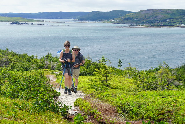
It took me about an hour to get from Bauline to the first lookout. That is the most strenuous part of the hike, so I was glad to get it over with early and it got much easier after that. I went on this hike solo and it was interesting because I hiked shortly after Hurricane Larry had passed through Newfoundland, so there was a lot of blowdown along the trail. I debated a few times if I was maybe getting myself into trouble climbing over the trees and would potentially get stuck somewhere further along the trail, but the first section was the worst and I didn’t encounter too much more downfall after that.

DSC00722

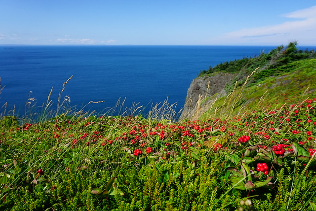
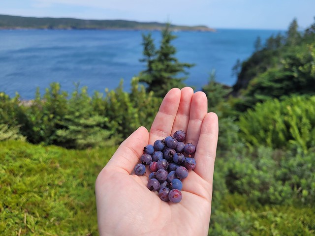
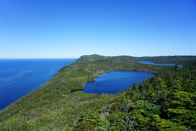
From the first lookout, you hike back down a little bit before ascending up to Piccos Ridge, which is the highest point along the trail. Even though it was getting later in September, I encountered quite a few berries in this section, particularly partridgeberries! You continue along the ridge for awhile before making a big decent through the trees towards several ponds. There is an unofficial campsite located at Brock’s Head Pond at about the 8.5km mark. I could only see room for 1 or 2 tents in the trees, but there is a bit more open space just past the pond at the river, which is the water source. There are no facilities.

DSC00738

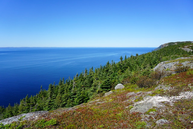
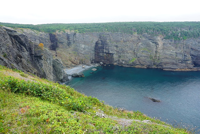
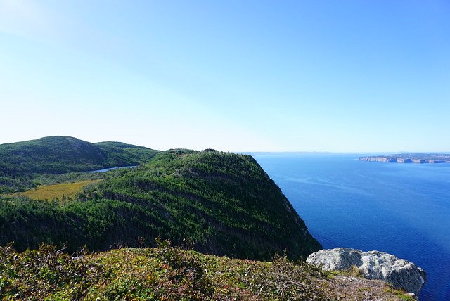
There’s one last uphill climb after the campsite, but then it’s smooth sailing after that! I think this was my favourite section of the hike because it’s all wide open and barren at the top. Piccos Ridge has a lot of different viewpoints, but large parts of the trail are in the trees, so I love hiking along the barren rock with the Atlantic stretched out alongside you. The view from this trail is into Conception Bay, so on a clear day you can see over to the other side of the peninsula and there are great views of Bell Island.

DSC00748

The rest of the trail is a steady downhill, so I can see how it’s a strenuous trail from either end, though the uphill is more gradual on the Portugal Cove side, which is why most people prefer that direction. Unfortunately I didn’t end up making it quite to the end of the trail. A few things came up and I decided to get off the trail a little early to try and make another appointment. Shortly after the 12km mark (so 2km before the trailhead in Portugal Cove), there’s a branch that exits off to Blast Hole Pond Road. The very top section of the road is gated, but then it’s gravel road which turns to asphalt. My knees were really bothering me, so I figured this would be an easier and quicker exit along the road, which was definitely the case. Mom was going to pick me up at the top, but I ended up powering it down the entire road before she got there. So overall I did the same distance, but skipped the last 2km to the official trailhead.

DSC00709

I would definitely go back sometime and hike up from the Portugal Cove side just to get the views. The highest view on that end is at 4km, but there’s views along most of the trail here, so you could hike as far as you want and then turn around for a shorter hike. In total it took me 5 hours, but I didn’t stop very much and I would recommend more time if you’re in a group or want to pick some berries. I did really like this section of the trail though considering Emily has been bad-mouthing it to me for years. There’s some ECT sections I wouldn’t want to do twice, but this definitely isn’t one of them!

DSC00754

ECT Series: Stiles Cove Path

When I first started hiking the East Coast Trail, I did a lot of the trails near St. John’s. It’s a long drive to get down to some of the hikes on the Southern Shore (especially since you need 2 cars for a lot of them), so it was easier to do hikes close to home. Stiles Cove Path runs from Flatrock to Pouch Cove; however, at 15.1km, it’s one of the longest trails on the northern part of the East Coast Trail, which means it was one of the last ones I did.

DSC09915

When I was home this summer (2021), I decided it was finally time to tackle Stiles Cove. The weather was extremely variable the entire time I was home, meaning it was hard to predict if you would have a clear day, a foggy day, or a rainy day (or more likely, all three!). Most of my friends were working during the weekdays, so I decided to hike Stiles Cove solo. I’ve been doing a lot of solo hiking in NL in recent years and have come to really enjoy it. There are much fewer wild animals to worry about in Newfoundland – black bear encounters are very unlikely (and the black bears are very small and skittish) – so your most likely encounter is probably a moose. It’s scary when you see them due to their size, but usually they don’t have much interest in you.

DSC09894

It was foggy almost every morning, but on the morning I decided to hike Stiles Cove, the forecast was predicting the weather would clear up, so I decided to go for it. My Mom dropped me out to Flatrock on her lunch break and agreed to come back to get me 5 hours later when she got off work. It was drizzling on the drive out and Mom was convinced it was going to rain for my whole hike (she really hates the rain) and that I would regret it. Fortunately, she was wrong! It was pretty misty when I started the trail and the fog was hanging along the coast, so there wasn’t a whole lot to see at first. The trail starts along the rocky coast and you go inland briefly near the beginning to cross the river, where there’s a nice little waterfall. I hiked about a kilometer before stopping for a quick lunch. It was still overcast, but I could tell the fog was already starting to lift a bit and I had a nice view back into Flatrock.

PSX_20210730_225131

From there the trail hikes up towards Red Head Cliff. It’s only a few kilometres into the trail and already, I had a trip highlight! Red Head is beautiful! It’s a sheer red cliff descending into the ocean, with a big grassy head to explore around. What made it so beautiful when I visited is that the fog had moved out enough that it was now hanging around the horizon, making it hard to tell where the ocean ended and the sky began. I thought it was incredibly beautiful and I love getting out of the trees and hiking along grassy knolls, so I was already very satisfied.

The trail continues down the head and along the edge of a cliff around Red Head Cove where I stumbled upon a few trail workers. They were working on improving some of the boards over the muddy section and were the only people I saw the entire day until I started the hike into Pouch Cove.

DSC09923

The next part of the hike is between Read Head Cove and Stiles Cove and is mostly in the woods. It breaks out of the woods a few times and I stopped to have another snack before continuing on. You can’t get to Stiles Cove on the trail, but the view down to the beach is gorgeous. It was still overcast when I passed by, but I can imagine that on a sunny day the water would be the brightest blue!

Again, the trail goes back into the woods as you continue towards Spout Cove, which marks the halfway point of the trail (7.5km). There are beautiful views through the trees as you approach the head and then you pop out on another grassy knoll. I could see this being a good camping spot if you wanted to do it overnight. There are no facilities, but I did notice a stream less than a kilometre away. I wasn’t progressing as quickly as I needed to to meet Mom at the end of the trail, but I couldn’t help stopping at Spout Cove because I had finally spotted some whales!

DSC09929

Whale-watching seems to be all about timing in Newfoundland. Some trips I don’t see a single whale, and other trips (this one), it’s like I can’t get away from them! There were several of them fishing further out and eventually I had to tear myself away to continue the hike. I didn’t make it far though as I was walking closer to the whales I’d been watching. Every now and then there would be a break in the trees and I would take a peep out to check on their progress. I knew I was getting closer because I could hear them spouting and spraying water through the trees! Eventually I came to a small viewpoint and hiked down the stairs to try my luck again. It ended up being the best show of the day! I was so close to the whales and there were 4 or 5 swimming around and diving, so I watched for as long as my schedule could spare.

DSC09965

After that it was back into the trees around Black Head North and I started making a better pace. The trail went in and out of the trees more, offering up some truly gorgeous grassy cliffside views (I’m a sucker for meadows if you haven’t noticed how much I talk about the grass). There are lots of sea stacks between Chimney Gulch and Shoe Cove – by now the clouds had finally broken up and I had a gorgeous sunny, blue sky day in which to finish the hike. I spent most of it chuckling at Mom and being very pleased with myself for starting the hike in the drizzle.

DSC00010

Even though I was still running behind, I couldn’t help but stop again when I arrived at Shoe Cove. Though Stiles Cove Path is 15km long, Shoe Cove is the only part of the trail that actually descends to a beach. The rest of the trail is along the bluffs, which makes for beautiful views, but every now and then it’s nice to actually go down to the water. Shoe Cove is a very narrow sheltered beach with a river pooling at the end of the beach before running into the ocean. There was no one around and I couldn’t resist going for a swim. First I thought I would just go in the river, which was insanely warm, but I decided to try the ocean too since it was so sheltered and was pleased to find that that water was actually pretty warm too! I didn’t have a swimsuit, so I went in my birthday suit, which is really such a freeing experience when you’re the only one around. I let the sun dry me off on the beach before continuing on to finish the last 3 kilometers of the hike. I had service, so I let Mom know I was running a little late.

DSC00023

But I didn’t need to worry, there’s an uphill section after Shoe Cove and then it’s a pretty easy hike into Pouch Cove. There’s one more viewpoint at George’s Point that I hiked down to, but regretted because then I had to hike back up again. The views coming into Pouch Cove are excellent! The trail is exposed as you come into town, which makes for a scenic end to the trail. My Dad picked me up at the Church in Pouch Cove and in all, my GPS tracked exactly 15km and 250m total in elevation gain. It took me just over 5 hours to hike the entire trail – I took lots of breaks, so I did have to hike pretty fast to finish in 5 hours. Also, the more people you hike with, the slower you will go, so I recommend giving yourself a bit more time if you’re hiking this trail.

Overall, Stiles Cove Path is incredibly scenic. It is a longer trail, at 15km, but I didn’t find it to be a very difficult trail and has minimal elevation gain overall, so I definitely recommend it!

20210729_170140
20210729_170503

Adventures along the Coast

In case you missed it, I recently spent 2 weeks home in Newfoundland (Part I, Part II). After spending the long weekend in Twillingate, we returned to St. John’s for the rest of my holiday, but not without a quick stop into Dildo on the way home. That’s right – if you’re not from Newfoundland, the name might sound strange to you, but Dildo is a vibrant coastal community on the Avalon Peninsula that was recently made popular by none other than Jimmy Kimmel. My interest in visiting was to stop into Dildo Brewing. Like I mentioned in my last post, a lot of breweries have been popping up in NL, but Dildo Brewing was definitely one of the earlier breweries and boasts a gorgeous view of the ocean.

20210802_163437

To be honest, I didn’t enjoy Dildo Brewing as much as Split Rock in Twillingate. It was super busy in the restaurant and the poor wait staff was run ragged, making for a bit of a lengthy and chaotic experience, but I did really enjoy sitting out on the patio and watching the water at least. We couldn’t get into the restaurant, so instead we enjoyed a surprisingly good fish and chips from the local gas station!

IMG-20210805-WA0000

I spent a lot more time visiting with friends and family; eating seafood, strolling the waterfront, and searching for the best ice cream. I returned to Signal Hill to hike it properly (not in debilitating fog) on Regatta Day and then met up with friends for a swim at Sunshine Rotary Park. The St. John’s Regatta is a pretty unique event – it’s the longest continuous running sporting event in North America – celebrating more than 100 years of races on Quidi Vidi Lake. The only times it’s been cancelled was during the War and last year because of Covid. It returned this year, though spectators were discouraged and no vendors were allowed along the lakefront. But what makes the Regatta so unique is that it’s actually a civic holiday. Most provinces have the first Monday off in August as a provincial holiday, as is the case in the rest of NL, but in St. John’s, businesses take the Regatta off instead. It’s the first Wednesday in August and a weather dependent holiday. So if you wake up to wind or rain on Wednesday, you still have to go to work and wait until Thursday to get your day off (as was the case this year).

DSC00144

Otherwise, I continued my hiking tour of the East Coast Trail. I did another solo hike, this time along Mickeleen’s Path, which is the section that runs from Bay Bulls to Witless Bay. I wasn’t expecting to like this section that much because I’d heard it was mostly forested, but I ended up having a really good time. There were a lot of trees at the beginning, but when you reach the end of the headland there are lots of beautiful views, which continue into Witless Bay. It was incredibly windy when I hiked the trail, but I managed to find some blueberries and see one whale hanging out in Bay Bulls. It’s a 7km trail and since I was alone, I had to hike back, but my friend gave me a head’s up that there’s an old ATV road that cuts across the headland through the woods, so I took that instead to save myself a bit of walking.

20210804_122946

I really wanted to do an overnight hike while I was home. A few years ago I brought all my gear home with me, only to get rained out, so I’d brought all my gear back with me again in hopes of getting out on the trail overnight. Since Emily was working during the week, we decided to try for the last weekend I was home. She’s already hiked a lot more of the East Coast Trail than me, so we decided on Cape Broyle Head Path, which is one of the few sections she hasn’t done. The only problem, it’s an 18km trail and over an hour drive away. So we convinced Mom and Dad to join us for the first section of the hike and then Mom returned again the next day to pick us up.

DSC00161

Cape Broyle Head Path runs from Cape Broyle to Calvert, but the campsite is located at km 7 of 18, so we decided to hike it starting in Calvert to do the bigger distance on the first day. The first part of the hike is really scenic and looks out towards the Ferryland Lighthouse. It was super windy, but it was a nice day and we had a good time. We continued on for a few kilometers hoping to find somewhere nice for lunch, but it seemed to mostly be a forested trail, so we ended up having our lunch in the woods before saying goodbye to our parents. They hiked back to the car while we continued on.

DSC00184

The trail continues on through the trees before punching through at a few viewpoints and one lone picnic table, something I’ve never seen on the ECT before! It took us awhile to wind our way along the trail before finally coming to Lance Cove. It was a beautiful looking beach, but we didn’t think we’d be able to access it from the trail and were thrilled when we found some steps descending down to the beach! We had a quick swim before continuing on to the Campsite at Freshwater River.

20210807_164031

We thought we’d have the campsite to ourselves, but were surprised to find someone else had set up a tent too. So we picked a tent pad up on the bluff, set up camp and had a delicious dinner of chili fettucine. It mind sound weird as it was a mix of whatever dried foods we could find around the house, but it ended up being delicious! The forecast had been a bit dicey all day and we were lucky not to have been rained on yet, so we crawled into our tent hoping it would be dry in the morning.

20210807_191417

Sadly it was not to be. While we tried to fall asleep we could see lightning across the bay and the rain eventually rolled into our campsite some time during the night. My tent held up well to NL’s rain and wind, but it was sadly still wet when we got up. We made a hasty tent breakfast before departing to hike out. Fortunately it stopped raining shortly after we starting hiking, but it didn’t help us at all as the trail is super narrow and the forest was extremely wet. In no time we were both soaked and blundered our way along the rest of the trail.

Fortunately Mom showed up to get us with a change of clothes and we were none the worse for wear. But sadly it also meant I’d reached the last day of my trip. I spent the rest of the day hastily trying to dry out all my gear to transport it home and we finished off the trip with one of my favourite meals and a few rounds of cards. I really wish the trip could have been longer, but fortunately my family had plans to visit less than a month later, so it was goodbye for only a short time.

20210805_123304