This will be a short blog post about a short trip, but it was exciting enough that I decided it was worth writing about! My friends wanted to get one last camping trip in before snow season and booked up 3 campsites at Kilby Park over the Remembrance Day long weekend. They all drove out after the Remembrance Day service on Thursday and Brandon and I joined them on Friday evening after work. It ended up pouring all Thursday night and most of Friday, so I didn’t regret my decision. The rain finally stopped as Brandon and I were driving out and it didn’t rain again until the following afternoon.
But a little bit of information about the Kilby Campground. Kilby Park is located near Harrison Mills and it was my first time visiting the area. Historically there was a mill located in the area and Kilby was the location of the train station, so people travelling between Chilliwack and New Westminster would stay in the area. At the time there was a 14 room hotel, general store, and post office located at the train station, so visitors would often stay the night. Today, the original building has been turned into a museum and a small campground developed along the river to provide revenue towards maintaining the site.
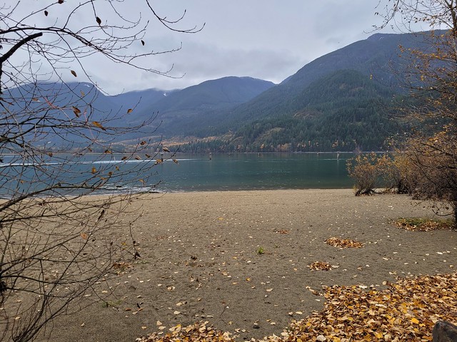
Like I said, I’d never heard of the park, but I was pleasantly surprised by it’s location. The campground is located right on the banks of the Harrison River where it empties into Harrison Bay and has gorgeous views. I would love to return in the summer and hang out on the sandy beach and go kayaking around the bay. On this particular trip though, it was pretty wet and chilly and the campground itself left a little something to be desired. The campsites are definitely intended for campers and RV’s and we were the only people staying there that were in tents. The sites have a strong parking lot vibe, with very few trees and little privacy. But the views really can’t be rivalled, so I wouldn’t be opposed to going back.
Brandon and I arrived just after sunset. The rest of our crew had been there for 24 hours already, so they had constructed a pretty good set-up, with several pop-ups over the picnic tables and fire. We’d gone on a pretty large wood finding mission before the trip and had stockpiled a huge pile of construction waste to burn through and keep us warm. Carolyn and Steve made our supper for the night and had cooked salmon and roasted veggies over the fire in tinfoil packages, which was delicious!
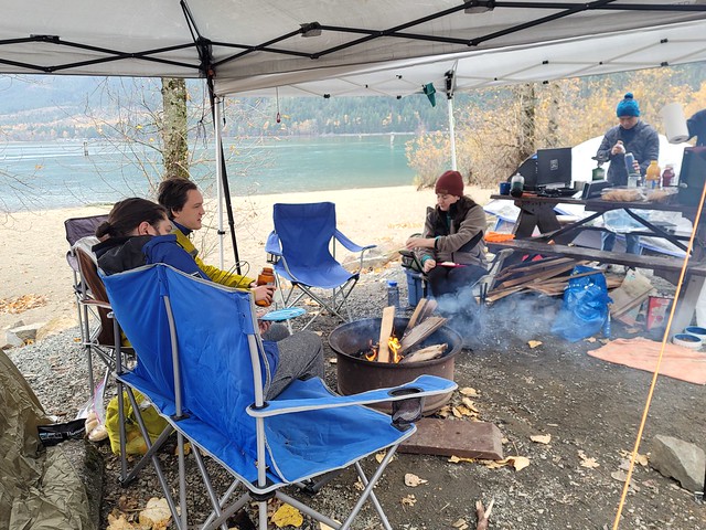
Unfortunately, though we had foreseen the rain, we hadn’t accounted for the wind. It’s very rare that we get wind at all in BC and as we were eating dinner, the wind started gusting up off the water and lifting up the pop ups. We tried pegging them down, but the sites are designed for campers and the ground quality was poor, so we ended up having to guyline every corner of the pop-ups as well. Fortunately that did the job and they didn’t give us any more problems after that. We spent the rest of the evening enjoying the fire and the break from the rain. Carolyn recently got a Golden-Doodle puppy named Jasper, so we loved getting to hang out and snuggle with him. I decided to leave Sadie home with Seth because she is pretty high maintenance and reactive and I didn’t think she would do well in the open-concept campsites (also I didn’t want to sleep with a wet dog).

We camped in Brandon’s tent and I finally had another reason to use my -30 degree sleeping bag, which obviously kept me super toasty warm all night. I slept better than expected and we got up with the sun at 8am for a full car camping breakfast of eggs, bologna, and hash browns. We also had a fabulous view of several eagles and saw 3 of them hanging out along the beach throughout the morning. We later learned we happened to be visiting during the Eagle festival, so it was nice of the eagles to show off for us!
Having a look at the upcoming forecast, we made the decision to take advantage of the dry weather to take down the tents. We’d been planning to stay Saturday night as well, but it was calling for an insane amount of rain starting in the afternoon, as well as wind, so we figured we didn’t want to battle both elements and have to take home a ton of wet gear in the morning. This ended up being an excellent decision as this was the weather event that ended up flooding entire towns in BC. At the time, the forecast was calling for 150mm of rain in the Fraser Valley, by the end of the storm, some areas of the province ended up getting close to 300mm of rain. This resulted in heavy flooding and destruction in Merritt, Hope, and Abbotsford, as well as the flooding and collapse of several highways, causing BC to declare a State of Emergency for the third time in 2021. So if you have any doubts about climate change, please educate yourself because the effects are very real and devastating.

Around noon we decided to check out the Kilby Museum. It’s only open on the weekends in the off-season, so we walked up the road and paid the $10 entrance fee to tour the museum. They’ve preserved the old hotel and store as much as possible and added several exhibits in the old hotel rooms about the development of the Fraser Valley through the years. We really enjoyed touring around and they have a really nice gift shop that also sells homemade pies! That’s where we learned about the historic use of the site and it was nice to learn something new.

It started to rain a bit after that and most of our party took off to head home. We stayed a little bit longer and Brandon cooked up his infamous Thai chicken curry for us and Carolyn and Steve. It did start to rain in earnest then though, so we packed up as much as possible, just leaving the pop-up over the picnic table until the last minute. Unfortunately, because we had cut the trip short, we had a lot of firewood leftover. I’m the only person with a yard and fire-pit at home, so we ended up loading all the leftover wood aboard Brandon’s car and Seth and I now have a huge stash for next year!
It was around 3:30pm when we left and it was torrential downpour the entire way home. We were very satisfied with our decision to leave early and didn’t fully understand just how wise that decision was until news started to break the next evening about the devastation the rain caused. So in conclusion, the Kilby sites leave a little something to be desired, but I would love to return in the summer to take advantage of recreation activities in Harrison Bay and would totally recommend checking out the museum.