Following up from Part I and Part II. The weather forecast for Day 3 was our worst while on the trail. There wasn’t any heavy rain in the forecast, but more concerning was the alert for 80km/h winds. It was only 11km to our next campsite, but we wanted to attempt the day hike up to Mirador Britannico, which is another 11km round trip, so overall, it was our longest day of hiking in Torres del Paine.

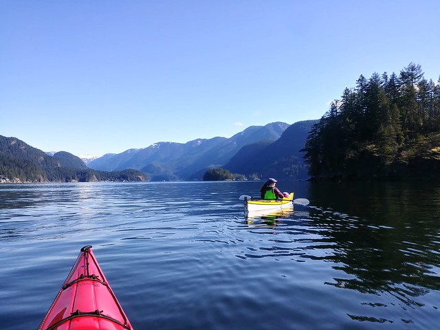
The clouds looked pretty foreboding when we left Paine Grande, and as anticipated, it was incredibly windy. But the moody weather produced some of the most striking photos of the stunning landscape! The dark clouds hung around the mountains, without always obstructing them, and occasionally the sun would break through, splintering rays of sunshine across the hillside. It was really pretty and we both loved the hike from Paine Grande to the ranger station at Italiano, which is where the day hike starts.
We arrived around lunch time, so we ate at the picnic tables as it started to rain. There’s a washroom with a big overhang for bag storage, so everyone leaves their backpacks while hiking up to the mirador. We re-packed our bags, putting everything we didn’t need in Seth’s, and everything we might want in mine. A lot of people just do the hike with a water bottle, but conditions were marginal and it is a remote trail, so I’m glad we brought all our essentials, as we did use them.


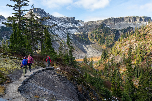
I struggled with the hike to Mirador Britannico. I think my biggest problem was that I’d heard from other hikers that it was an easier-than-expected trail. Even though there is 600 metres of elevation gain, I heard that it was pretty gradual and I didn’t properly manage my expectations. A large portion of the hike is a gradual incline, but it’s not the full story. The first kilometer of the trail is pretty flat, but then it gets quite steep very quickly and is surprisingly technical, with lots of tree roots and boulders. It was raining throughout the entire climb and I started overheating in my rain pants, so I got pretty cranky, despite gorgeous views of the surrounding glaciers.


After a while, the hike definitely flattens out, with one steep push to the top at the very end. About halfway to the summit, the rain transitioned to snow, so the visibility was pretty poor. I definitely questioned turning around, but couldn’t quite bring myself to do it. I picked up a lot of the slack for Seth on day 1 (giving him my hiking poles and carrying a bunch of his gear), and he came through for me on day 3. He ended up really liking this section and carried our shared pack most of the way there. On day 5, we transitioned again and I carried the pack for our sunrise hike when he was struggling, so overall, I guess we do make a good team!


We were pretty slow, but eventually we made it to the top! We didn’t get much of a view, but it was still a pretty cool experience. My new problem was that it was very cold and my pants were soaked through from the lack of breathability in my rain pants. This was definitely a flaw in my set-up, so I’m glad we had brought lots of extra emergency layers in our backpack and we layered up and enjoyed our snacks. Fortunately, my pants are quick dry, so they dried out really fast on the way down, which was helped by the fact that it finally stopped raining.
There were a lot of day hikers doing the mirador when we were hiking up, but somehow we got passed by almost all of them. We only passed a handful of people on our descent and by the time we got back to Italiano, there were less than a dozen bags remaining. So this wasn’t our swiftest hiking trip, but we stopped to take more photos and videos on the way down and my mood improved a lot.

We hiked the last 2km to Frances Campground, where we’d be staying for the night. There’s no big refugio at Frances, just some small dome structures, but they are expensive, so we opted to stay in one of the permanent tents instead. Both Frances and Chileno Campgrounds have elevated tents that you can book. They’re basically those platform tents that people set up on top of their cars, but in this case, they were elevated platforms in the woods. They were massive inside, so it was pretty cool, but a bit annoying to climb in and out of. We were later arriving to the campground than other days, so we quickly ate supper and went to bed!
Lucky for us, the weather started to shift on Day 4. There was still some wind and rain in the forecast, but it tapered off throughout the day. We had to hike 16km from Frances Campground to Chileno Campground. Chileno is a smaller site, but it’s one of the most popular because it’s the closest campsite to the Towers. We left Frances and had a pretty easy walk to Los Cuernos Campground, which is a bigger and nicer site than Frances. It has a proper refugio, unlike Frances, but it’s still smaller than Grey or Paine Grande.


The morning hike was mostly in the trees, with a short walk along the lakeside beach. It sprinkled rain for an hour or so, but it cleared up after that and we didn’t get any more rain on the trip. Most of the day was a slow ascent along the mountainside, which looks out over Lago Nordenskjold, an absolutely massive lake. The trail peaks after ~7km at Mirador Cuernos, and we decided to stop for lunch, it has a gorgeous lakeview, but it’s still pretty windy.
The weather improved in the afternoon and the clouds started to disperse as we continued meandering along the mountainside. Eventually you come to a branch and you can either continue back towards the park entrance, or take a connector trail up towards Chileno. It’s a great shortcut when you’re hiking the W-trek and it’s an absolutely beautiful section of trail. It’s mostly meadows as the trail ascends through the foothills towards the pass to the Towers, but the real benefit was that it was almost completely empty (we only saw 4 people)!

The sun finally showed its face in the late afternoon and it was the first time on the trail where we could hike in shorts and t-shirt. We took another break to enjoy the view, before continuing our trek up to the main trail. The trail merges just before Windy Pass, which is a high point along this section. It was surprisingly not windy in the pass and there’s a gorgeous view looking down over a canyon to the Rio Ascencio. The trail was much busier, but it was mid-afternoon, so not as busy as it would be in the early morning when everyone is starting their climb to the Towers.
From Windy Pass, you descend along the open canyon trail to Chileno Campground. It’s a really cool campsite in that it overlooks the river and has a nice bar where you can enjoy a drink after hiking the Towers. But it was the least accommodating campsite we’d visited. The refugio at Chileno is tiny, so most people who stay there, stay in the platform tents (which is what we did).


The problem is that this refugio is highly focused on profits – if you’re not staying in the campground, they charge you to use the bathrooms (which are NOT well maintained), and they want everyone to pay for meals in the dining hall, so they only provide one single 4-person table for everyone who wants to cook. It was extremely annoying considering we did pay a lot of money for a tent. Plus, you’re only actually permitted to use this table when they’re not actively serving dinner, which means there’s a blackout between 5:30 and 8:30pm. So we ate very early and then hung out before going to bed.
An early night was required because we were planning to hike up to the Towers for sunrise. We got some experience sunrise hiking on the Sendero al Fitz Roy, but the hike to the Towers is double the length of what we did in Argentina, so we planned for a very early rise. However, we got incredibly lucky with the weather. The clouds continued to clear all evening and when I woke up in the middle of the night to pee, I almost lost my mind over the star-speckled sky that greeted me. We were incredibly remote, so it was easy to see the milky way and I stumbled around in the dark enjoying the night sky before heading back to bed. Check back for the final story in Part IV.