ECT Series: Stiles Cove Path

When I first started hiking the East Coast Trail, I did a lot of the trails near St. John’s. It’s a long drive to get down to some of the hikes on the Southern Shore (especially since you need 2 cars for a lot of them), so it was easier to do hikes close to home. Stiles Cove Path runs from Flatrock to Pouch Cove; however, at 15.1km, it’s one of the longest trails on the northern part of the East Coast Trail, which means it was one of the last ones I did.

DSC09915

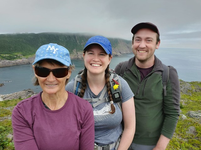
When I was home this summer (2021), I decided it was finally time to tackle Stiles Cove. The weather was extremely variable the entire time I was home, meaning it was hard to predict if you would have a clear day, a foggy day, or a rainy day (or more likely, all three!). Most of my friends were working during the weekdays, so I decided to hike Stiles Cove solo. I’ve been doing a lot of solo hiking in NL in recent years and have come to really enjoy it. There are much fewer wild animals to worry about in Newfoundland – black bear encounters are very unlikely (and the black bears are very small and skittish) – so your most likely encounter is probably a moose. It’s scary when you see them due to their size, but usually they don’t have much interest in you.

DSC09894

It was foggy almost every morning, but on the morning I decided to hike Stiles Cove, the forecast was predicting the weather would clear up, so I decided to go for it. My Mom dropped me out to Flatrock on her lunch break and agreed to come back to get me 5 hours later when she got off work. It was drizzling on the drive out and Mom was convinced it was going to rain for my whole hike (she really hates the rain) and that I would regret it. Fortunately, she was wrong! It was pretty misty when I started the trail and the fog was hanging along the coast, so there wasn’t a whole lot to see at first. The trail starts along the rocky coast and you go inland briefly near the beginning to cross the river, where there’s a nice little waterfall. I hiked about a kilometer before stopping for a quick lunch. It was still overcast, but I could tell the fog was already starting to lift a bit and I had a nice view back into Flatrock.

PSX_20210730_225131

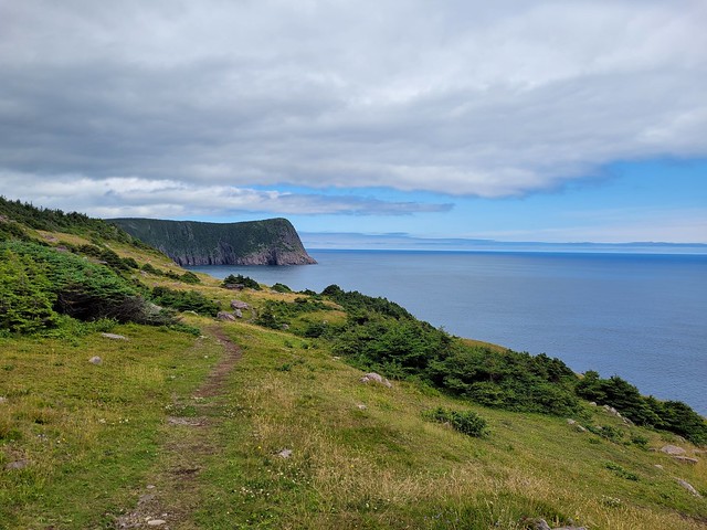
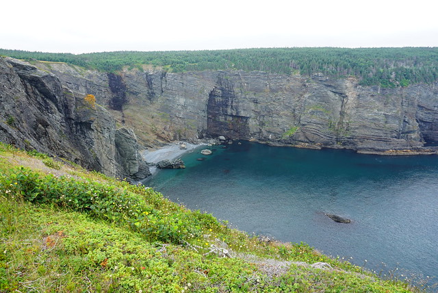
From there the trail hikes up towards Red Head Cliff. It’s only a few kilometres into the trail and already, I had a trip highlight! Red Head is beautiful! It’s a sheer red cliff descending into the ocean, with a big grassy head to explore around. What made it so beautiful when I visited is that the fog had moved out enough that it was now hanging around the horizon, making it hard to tell where the ocean ended and the sky began. I thought it was incredibly beautiful and I love getting out of the trees and hiking along grassy knolls, so I was already very satisfied.

The trail continues down the head and along the edge of a cliff around Red Head Cove where I stumbled upon a few trail workers. They were working on improving some of the boards over the muddy section and were the only people I saw the entire day until I started the hike into Pouch Cove.

DSC09923

The next part of the hike is between Read Head Cove and Stiles Cove and is mostly in the woods. It breaks out of the woods a few times and I stopped to have another snack before continuing on. You can’t get to Stiles Cove on the trail, but the view down to the beach is gorgeous. It was still overcast when I passed by, but I can imagine that on a sunny day the water would be the brightest blue!

Again, the trail goes back into the woods as you continue towards Spout Cove, which marks the halfway point of the trail (7.5km). There are beautiful views through the trees as you approach the head and then you pop out on another grassy knoll. I could see this being a good camping spot if you wanted to do it overnight. There are no facilities, but I did notice a stream less than a kilometre away. I wasn’t progressing as quickly as I needed to to meet Mom at the end of the trail, but I couldn’t help stopping at Spout Cove because I had finally spotted some whales!

DSC09929

Whale-watching seems to be all about timing in Newfoundland. Some trips I don’t see a single whale, and other trips (this one), it’s like I can’t get away from them! There were several of them fishing further out and eventually I had to tear myself away to continue the hike. I didn’t make it far though as I was walking closer to the whales I’d been watching. Every now and then there would be a break in the trees and I would take a peep out to check on their progress. I knew I was getting closer because I could hear them spouting and spraying water through the trees! Eventually I came to a small viewpoint and hiked down the stairs to try my luck again. It ended up being the best show of the day! I was so close to the whales and there were 4 or 5 swimming around and diving, so I watched for as long as my schedule could spare.

DSC09965

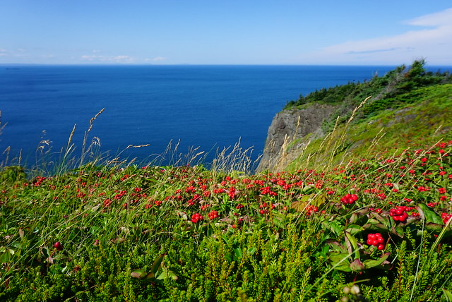
After that it was back into the trees around Black Head North and I started making a better pace. The trail went in and out of the trees more, offering up some truly gorgeous grassy cliffside views (I’m a sucker for meadows if you haven’t noticed how much I talk about the grass). There are lots of sea stacks between Chimney Gulch and Shoe Cove – by now the clouds had finally broken up and I had a gorgeous sunny, blue sky day in which to finish the hike. I spent most of it chuckling at Mom and being very pleased with myself for starting the hike in the drizzle.

DSC00010

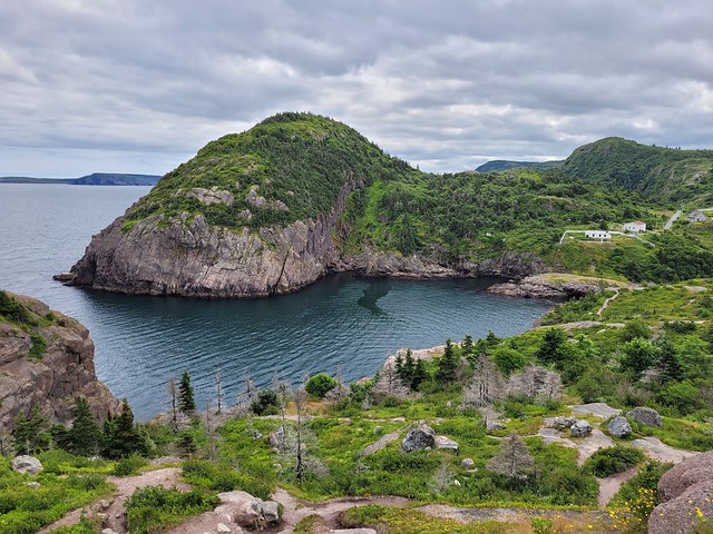
Even though I was still running behind, I couldn’t help but stop again when I arrived at Shoe Cove. Though Stiles Cove Path is 15km long, Shoe Cove is the only part of the trail that actually descends to a beach. The rest of the trail is along the bluffs, which makes for beautiful views, but every now and then it’s nice to actually go down to the water. Shoe Cove is a very narrow sheltered beach with a river pooling at the end of the beach before running into the ocean. There was no one around and I couldn’t resist going for a swim. First I thought I would just go in the river, which was insanely warm, but I decided to try the ocean too since it was so sheltered and was pleased to find that that water was actually pretty warm too! I didn’t have a swimsuit, so I went in my birthday suit, which is really such a freeing experience when you’re the only one around. I let the sun dry me off on the beach before continuing on to finish the last 3 kilometers of the hike. I had service, so I let Mom know I was running a little late.

DSC00023

But I didn’t need to worry, there’s an uphill section after Shoe Cove and then it’s a pretty easy hike into Pouch Cove. There’s one more viewpoint at George’s Point that I hiked down to, but regretted because then I had to hike back up again. The views coming into Pouch Cove are excellent! The trail is exposed as you come into town, which makes for a scenic end to the trail. My Dad picked me up at the Church in Pouch Cove and in all, my GPS tracked exactly 15km and 250m total in elevation gain. It took me just over 5 hours to hike the entire trail – I took lots of breaks, so I did have to hike pretty fast to finish in 5 hours. Also, the more people you hike with, the slower you will go, so I recommend giving yourself a bit more time if you’re hiking this trail.

Overall, Stiles Cove Path is incredibly scenic. It is a longer trail, at 15km, but I didn’t find it to be a very difficult trail and has minimal elevation gain overall, so I definitely recommend it!

20210729_170140
20210729_170503

ECT Series: Sugarloaf Path

I’m going to kick off my East Coast Trail series with a post about the Sugarloaf Path, which runs from Logy Bay to Quidi Vidi. It’s the most accessible trail from St. John’s and has many beautiful views along the coast, though it is rated as difficult on the ECT website.

From my experience, the website slightly overestimates trail lengths and this 8.9km trail tracked as 8.5km on my GPS when I did it. Personally I don’t think it’s a very difficult trail, certainly it’s well maintained and easy to navigate, but there are two climbs throughout the trail, which is what I think contributes to the “difficult” rating. You can do the trail in either direction, the difficulty is approximately the same either way, with both directions starting with a big climb. I’ve done the trail twice, both times starting at the Ocean Science Center in Logy Bay and ending in Quidi Vidi. I like this direction because you end with a beautiful view looking down into the gut. But, the view into Logy Bay is also gorgeous, so you can’t go wrong with either direction!

IMG-20210726-WA0001

Like I said, from the Ocean Science Center, the hike starts with a climb up to the top of the bluff. I don’t find it too bad and often hike up and back just for the view. It’s a great area for blueberry picking in the Fall, but popular and often picked clean. There’s a great view down into Logy Bay from Devil’s Point and looking out towards Cape Spear at Sugarloaf Head, which is the highest point on the hike. After that, it’s a pretty gradual descent through the trees around Robin Hood Bay.

Robin Hood Bay is the only real downside of this hike. For those from St. John’s, you’ll know that this is the location of the town dump. In past years, this has created a lot of debris and plastic garbage that’s blown across the trail, but thanks to a ban on plastic bags and capping at the landfill, I couldn’t believe how much the trail was improved on my last hike here in July 2021. I visited with Sean and my Mom and we were quite impressed with how much nicer the trail is through this section now!

20210726_112844

You reach Small Point at around the halfway point in the trail, breaking out of the trees into a gorgeous meadow! It has beautiful views and makes for a great place to stop for lunch, which is what we did on our visit. The East Coast Trail is a trail that definitely benefits from nice weather. The first time I did the trail was in 2013 with Seth and it was a super foggy day, meaning that we could barely even see the ocean, despite being right next to it. On this visit, we started in the fog, but it quickly cleared out and we had a lovely view of the Atlantic from Small Point, it was honestly like a completely different trail for me!

20210726_124824

There’s an old bunker located along the cliffside in this stretch, which Sean informed us was an old lookout for U-boats and that there are many of them scattered along the trail (he works for Parks Canada). We did a little bit of poking around, but it’s dug out of the cliffside and the ladder is busted, so I wouldn’t recommend going inside. We got lucky though and saw a bunch of whales fishing off the coast while we were hiking along the exposed sections.

After Small Point, the trail meanders in and out of the woods. We could still hear the whales spouting while we were in the trees and then every now and then we would pop out of the trees to catch up with them. There’s a nice little river crossing at Bobbies Cove, shortly after which you reach an old road, which is the low elevation point on the hike. You start the second climb of the trail after that; it is a bit steep, but like most of the ECT, there are stairs on this section, so you can just take your time and it doesn’t take too long to get back up to the top of the bluff.

20210726_124625

Shortly after Boulder’s Cove, you reach the top of the climb and have the most gorgeous view looking down towards Quidi Vidi. Then it’s only a short walk back down towards the gut. Pay close attention to the trail markers in this section though – it’s frequented by mountain bikers, so there are a lot of other paths crisscrossing the ECT. It is easier to follow the path up from the other direction, which is one of the benefits of doing the path in reverse. It looks like any of the paths should get you down, but there is one tricky section where there’s a bit of a ravine and only one path across, so if you get off the official ECT, you might miss it and then have to climb back up. Me and Seth got super lost when we did it, but we knew to pay attention when I did it with Sean and Mom and we didn’t have any problems.

20210726_141251

The fun thing about the ECT is because NL is so rocky and barren, you often have to look down for trail markers, which are affixed directly to the rock. Watch for arrows engraved and painted in the rock, or the wooden trail stakes, which are painted striped black and white. The universal symbol along the trail for the ECT is a white triangle.

Eventually you reach the end of the trail along Cadet Road, right before the village. You can leave a second car parked along the road, otherwise you’ll have to go back to Logy Bay or get picked up. The trail ends right next to the Plantation and Brewery, so check out the local artisans, have a pint, or see if the local ice cream truck is open for a sweet treat if you’re there in the summer!

20210726_135803

East Coast Trail Hiking Series

I’ve decided to branch out a bit with a new series about hiking the East Coast Trail. I’ve done a ton of hiking (and blog posts) about my adventures in BC and my travels abroad, but I haven’t taken the time to write about one of my all time favourite trails. I grew up in St. John’s, Newfoundland and have spent lots of time hiking this unique trail over the past 10 years or so. I figured it was time to share it with the rest of you!

The East Coast Trail is approximately 300km of trail that runs down the entire coast of Newfoundland’s Avalon Peninsula. It’s hard to determine the exact length of the trail because it stops in many communities as you travel down the coast and can be completed either as a thru-hike, or much more popularly, as section hikes. According to the East Coast Trail Association, which maintains and manages the trails, the trail is comprised of 25 paths that connect more than 30 coastal communities. It you opt to do the trail as a thru-hike it would be more than 300km with all the road walking between communities. The longest section of trail is 23km, so most Newfoundlanders opt to do the trail as a series of section hikes, either with 2 vehicles or as a round trip. You are permitted to camp anywhere along the trail, but there are 5 official campsites along the larger sections of trail if you want to do some sections as an overnight.

PSX_20210801_001531

The trail is entirely coastal, though of course it does go through large sections of wooded areas where the coast is not directly accessible. While it’s not mountainous, it is still a very strenuous trail as it will take you up and down through many beaches, coves, and headlands over the length of the trail. Some trails are more well maintained than others, making for some pretty technical hikes along some of the longer and less travelled paths. But the trail passes through some of the most beautiful coastline and rural communities and I love hiking there on a sunny day, with the wind blowing at my back, eating copious amounts of fresh berries and watching the whales fish along the cliffs.

I’ve slowly been working on tackling this trail over the past 10 years and currently I am about 60% complete. However, the ECT association is always working on continuing to expand the trail and have added 4 trails down the northwest side of the peninsula over the past few years, so the trail is always growing! There’s some variation in paths and I have 28 to complete on my list. My plan is to list all the trails here and then work on individual blog posts for the sections I’ve completed and link them back here as I go.

TrailFromToDistanceTimeRating
Long Shore PathTopsailPortugal Cove17.2km6-8 hoursStrenuous
Piccos Ridge PathPortugal CoveBauline14.5km7-9 hoursStrenuous
White Horse PathBaulineCape St. Francis18.2km8-10 hoursStrenuous
Biscan Cove PathCape St. FrancisPouch Cove7km2-4 hoursModerate
Stiles Cove PathPouch CoveFlatrock15.1km5-7 hoursDifficult
Father Troy’s TrailFlatrockTorbay8.9km2-4 hoursModerate
Silver Mine Head PathTorbayMiddle Cove1.9km1-2 hoursEasy
Cobblers PathOuter CoveLogy Bay5km2-3 hoursModerate
Sugarloaf PathLogy BayQuidi Vidi8.8km3-5 hoursDifficult
Signal Hill Trail**Quidi VidiThe Battery3km1-2 hoursModerate
Deadmans Bay PathFort AmherstBlackhead10.5km4-7 hoursDifficult
Blackhead PathBlackheadCape Spear4.4km1-2 hoursModerate
Cape Spear PathCape SpearMaddox Cove11km4-6 hoursModerate
Motion Path*Petty HarbourShoal Bay Road20.1km5-8 hoursDifficult
Spout Path*Shoal Bay RoadBay Bulls22.5km7-9 hoursStrenuous
Mickeleens PathBay BullsWitless Bay7.2km2-4 hoursModerate
Beaches PathWitless BayMobile7.1km2-3 hoursEasy
Tinkers Point PathMobileTors Cove5km2-3 hoursEasy
La Manche Village PathTors CoveLa Manche7.8km2-3 hoursEasy
Flamber Head Path*La MancheBrigus South12.9km5-8 hoursDifficult
Brigus Head PathBrigus SouthAdmiral’s Cove6.4km2-3 hoursModerate
Cape Broyle Head Path*Cape BroyleCalvert18.3km7-10 hoursStrenuous
Caplin Bay PathCalvertFerryland5.6km2-3 hoursEasy
Sounding Hills PathFerrylandAquaforte5.4km2-3 hoursModerate
Mudder Wet PathAquaforteAquaforte2.9km1-2 hoursEasy
Spurwink Island Path*AquafortePort Kirwan17.1km7-9 hoursDifficult
Bear Cove Point PathPort KirwanRenews11.9km4-6 hoursModerate
Island Meadow PathRenewsCappahayden10km3-5 hoursModerate
Total285km
*Campsite located on trail **not official ECT section