I needed a bit of a writing break to start the year. I had a lot of summer and fall adventures to write about, but it’s been pretty low key for me in December and onwards. I was hoping to go on some winter adventures through the holidays, but it’s been a very late start to winter in BC and to be honest, I needed some rest time. So mostly I spent my holidays holed up inside doing jigsaw puzzles and listening to audiobooks.
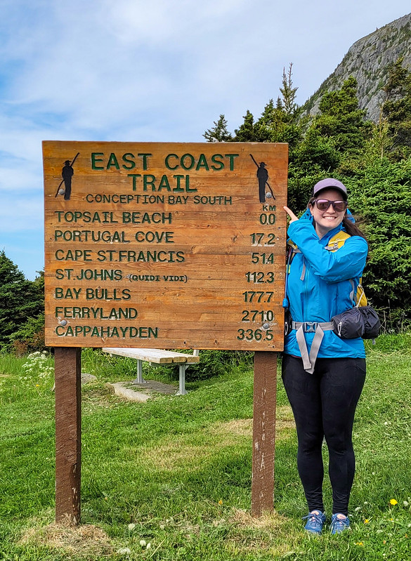
To start the year, I decided to expand my Newfoundland series for the next few weeks since I don’t have a lot of winter activities to write about at the moment. I’ve been working on completing the East Coast Trail for several years now and I think I might be in a position to finish it this year, so I figured it’s a good time to get caught up on some of my trails!
I first did Biscan Cove Path back in 2016 and at that time, the road to Cape St. Francis was in really rough shape and Biscan Cove Path itself took a lot longer than I anticipated. I returned to the trail in late June 2023 and generally had a much better experience on the trail than in 2016. Biscan Cove Path runs from Pouch Cove to the lighthouse at Cape St. Francis, which is the most northerly point on the East Coast Trail. At one point, I think it might have been the start of the entire ECT, but the trail has since wrapped down the other side of the avalon peninsula towards CBS.
This was a bit of a tricky trail for section hikers because the paved road pretty much ends in Pouch Cove and the gravel road to the lighthouse used to be in really terrible shape. But it was recently graded, so it’s much easier to do this trail with 2 cars now. The first time I did it, I skipped the extra 1km to the lighthouse and hiked from Biscan Cove to Pouch Cove. On my more recent visit, I started in Pouch Cove and generally liked the experience more because you can end at the lighthouse, which is a really nice place to whale watch while eating your lunch.
You can park your car next to the field at Memorial Park in Pouch Cove and then walk up the road to the trailhead at Baldhead Road. It’s just over 8km from Pouch Cove to Cape St. Francis and it took me and Mom a little over 2.5 hours to do last summer. We made a pretty quick pace with just the two of us, but it can be a deceiving trail. When I did it the first time, it took us more like 4 hours to complete, but it was with a much bigger group and we picked a lot of blueberries.
I actually like this trail a lot though. There’s quite a few forest sections, but there’s also a lot of viewpoints. It’s a fairly varied trail and Mom and I pushed all the way to the end before stopping. The trail technically ends at Biscan Cove, where there’s a parking lot. It’s another 600m to hike out the road to the lighthouse at the point, but it’s definitely worth it to walk out there, more so for the whale watching than the lighthouse.
As usual, it was really windy out there, but we sheltered by the side of the lighthouse and ate our lunch while watching the whales play. The first time I did the hike, I brought 2 cars. On this occasion, we didn’t have a second car, so I convinced mom to just walk back the gravel road to Pouch Cove. It does add another 4km to the hike if you walk back the road, so Mom was really cranky about adding another hour to the walk on the way back.
Fortunately there were some other hikers around at the same time, so we only had to walk 0.5km before we were able to hitchhike back to Pouch Cove with a friendly hiker. The East Coast Trail doesn’t see that much foot traffic and the gravel road to Cape St. Francis sees even less, so this is definitely not a reliable option. But it also wasn’t a big deal to me to walk another hour back to the car (though driving was definitely preferable).
So overall, Biscan Trail is a pretty short path, but it’s located close to St. John’s, so it makes for a nice afternoon hike in the summertime! I was happy to return to see the lighthouse.
The last few years I’ve been home I’ve brought all my camping gear with me in hopes of getting in an overnight on the East Coast Trail. Last year I was finally successful with Cape Broyle Head Trail and this year we were lucky enough to hike Motion Path overnight!
I feel like a broken record, but this may be one of my all time favourite sections! It’s definitely up there with the Spout and since they share the same coastline I hope to one day do them back to back. Together Motion Path and The Spout make up ~31km of continuous coastline between Petty Harbour and Bay Bulls – this is the longest uninterrupted stretch on the entire trail and there are two campsites, one on each path. I’m assuming they’ve been broken up into 2 trails due to the length, with Shoal Bay Road delineating between them. Shoal Bay Road is an old overgrown ATV road that runs from the Goulds to the midpoint of the trails. It’s not considered official ECT, so it adds ~7km to whichever hike you’re doing.
We didn’t have enough time to do the whole thing, so we just did Motion Path, which runs from Shoal Bay Road to Petty Harbour, totaling ~21km. I went with Emily and because she’s working all week, we only had one shot at the trail and prayed the weather would cooperate. She worked until 3pm on Friday and then we picked her up and our Dad dropped us off at the entrance to Shoal Bay Road in the Goulds. We’ve both done Shoal Bay Road before when we day hiked The Spout and Emily has also done Motion Path as an overnight once before. So we knew what to expect with Shoal Bay Road. It’s completely in the woods with a lot of loose gravel and water ponding. It’s not difficult, but 7km of boring access road does feel like a slog. It’s usually very wet, but it hadn’t rained all week, so it was pretty dry and we only had to detour around large puddles twice.
It was a really nice day and the sun was shining as we set out on the trail. It was around 4pm when we started and it took us about an hour and a half to reach the coast. It started to cloud over along the way and we could see the fog hanging out offshore as we started the 2km of coastal trail to the campsite at Miner’s Point. This section wasn’t particularly scenic, but we did see a few waterfalls and get some nice views looking north towards Heart’s Point.
It was a really nice day and the sun was shining as we set out on the trail. It was around 4pm when we started and it took us about an hour and a half to reach the coast. It started to cloud over along the way and we could see the fog hanging out offshore as we started the 2km of coastal trail to the campsite at Miner’s Point. This section wasn’t particularly scenic, but we did see a few waterfalls and get some nice views looking north towards Heart’s Point.
It took us another hour to get to the campsite and we strolled into the sheltered birch forest where it’s located around 6:30pm. We fully expected to be the only people camping there, but there were two guys already set up and another couple showed up shortly after up – so pretty busy for the ECT! There is one premium camping spot, which the guys had snagged, but it’s pretty slim pickings after that. A lot of the ECT campsites have tent pads, but Miner’s Point just has some flat grassy spots. We counted 5 or 6 of them, but they were all pretty small and bumpy except for the one good one. Fortunately it was grassy though, so it made for a soft bed!
We picked the best place to pitch the tent and then spent the rest of the night taking it easy and making supper. The fog rolled in really thick right after we arrived, but the wind kept changing direction and sent it rolling in and out of the campsite. When it was sunny, it was quite nice with the birch trees. There is a small stream running through the campsite, but it’s definitely not the best water source and I could see it running dry if there was a particular dry spell (although that’s pretty rare in NL). We were able to find one section that was running decent, but you definitely need a filter. If you continue on towards motion point, you will cross some better sources.
It took us a little while to get warm overnight with the fog and we must have been on a slope because we woke up with both of us bunched to one side of the tent. It was an early wake up call because the sun was out in full force in the morning and it felt like we were being cooked inside the tent! I woke up at 6:30am and opened up the vestibules to get some air flowing, but we were both up and making breakfast shortly after 7am.
I haven’t done much overnighting in Newfoundland, but Emily would agree with me in saying we’ve never had such a warm morning on the trail in Newfoundland! There wasn’t any wind in the trees and the sun was shining right down on us, so I immediately put on shorts and sunscreen. Unfortunately the lack of wind also brought the flies, so it gave us the motivation for a quick breakfast and pack-up. We were all done and ready to hike at 8:30am, which must be a new record for us.
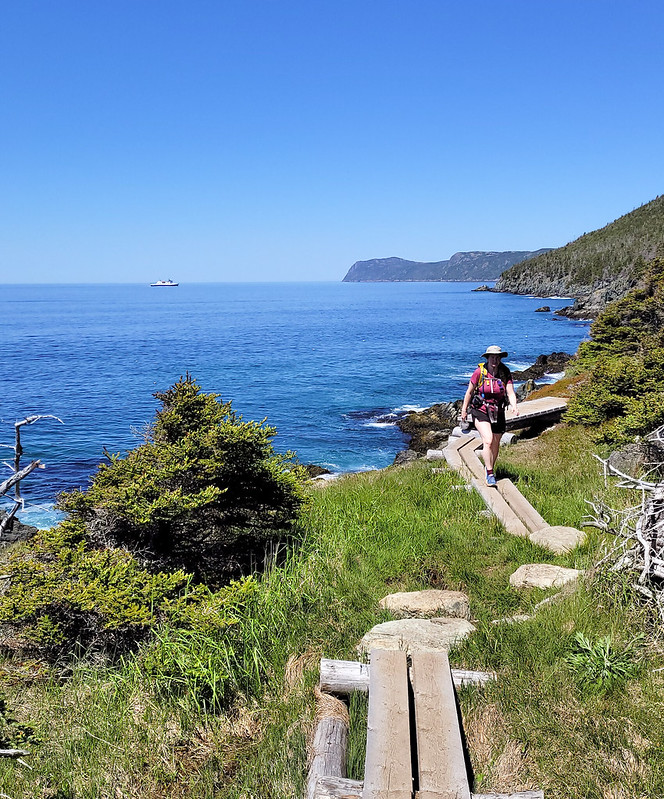
Our plan for the rest of the day was to hike the 11.5km back along Motion Path to Petty Harbour. You leave the birch forest and then pretty much the entire rest of the hike is exposed along the coast. It would be brutal in the rain, but on a sunny day like we had, it was an absolute dream! 11.5km of unbroken coastal views!
I can see this trail being a bit challenging as a day hike due to the length, but as an overnight it makes for a really great day of hiking. There’s a few short climbs, but overall it’s an easy trail, you just need extra time to accommodate photographing all the amazing views along the way! There’s a few water sources right after the campsite and then you start climbing up towards Heart’s Point. From there you can see all the way back to the lighthouse in Bay Bulls and the trail undulates up and down once you get to the top of the bluff.
My favourite part of the trail is coming down from Heart’s Point towards Lower Cove – you can see all the way out to Motion Point and it is really cool to see the ponds sitting so close to the ocean. On a nice day, I would love to try swimming in Lower Pond, but even though it was sunny, it was quite windy and we would get cold whenever we stopped (though it was comfortable in shorts when we were moving). The trail loops right around Motion Head and we were super enthused to hear some whales surfacing when we stopped for a snack break!
It took us a little while to find them, but we could see several offshore, which meant the caplin had finally arrived. I wasn’t expecting to see whales in mid-June, so I felt lucky to see them just as they arrived and I was getting ready to leave. Right before we hit Lower Cove Head we were treated to a real show! The trail descends pretty close to the water in this section and there just so happened to be a few whales fishing right off the coast! We think they were minke whales and saw a mama and calf from a very close distance!
We passed 2 other hikers going in the other direction around Motion Head and anther trio close to the end of the trail, otherwise we didn’t see anyone else on the trail on day. We made pretty slow progress in the morning, but picked up the pace around Motion Head, where the trail is really flat and easy. At Motion Head we had the privilege of seeing a humpback whale breaching way off in the distance, but after we turned the corner towards Petty Harbour we didn’t see any more whales and the weather started to shift.
The day had started out with blue skies and not a cloud to be seen, but things don’t often stay that way in Newfoundland and the clouds were blowing in over the trail. We still weren’t too concerned as we continued along Motion Bay and stopped for lunch at Merrymeeting Point. Unfortunately the wind was picking up, so it was chilly and we made it a quick break before starting the last climb into Petty Harbour. We made pretty quick time on the hike up because some pretty ugly looking rain clouds were rolling in and we quickly alerted Dad to come and pick us up before the rain began.
If you’re not used to climbing, this is definitely the most challenging part of the trail. The trail ascends about 120m up over the head, where there’s a short flat section and the final descent into Petty Harbour. It’s a bit steeper on the Petty Harbour side and more gradual going out towards Motion Head if that influences your decision about which direction to hike the trail. We didn’t like the steep drop into Petty Harbour, but it is very short and only took us about 10 minutes. It did start to drizzle as we were descending, but it was only a small amount of rain. Normally that wouldn’t both me, but I had a flight back to Vancouver early the next morning and didn’t want wet gear, so I put on my pack cover and hurried down the trail.
We hit Petty Harbour after 4 hours of hiking and only had to wait 5 minutes for Dad to pick us up. The rain picked up right after we finished and it was a good reminder how quickly the weather can change! But lucky for us, we were dry at home after an excellent overnight trip. I’m so glad I got to squeeze this trail in and hope to return one day and do the entire section from Petty Harbour to Bay Bulls. It’s a bit on the long side for a day hike, but if you’re looking to try overnighting, this is a great trail! Super scenic and not too difficult, I’d recommend.
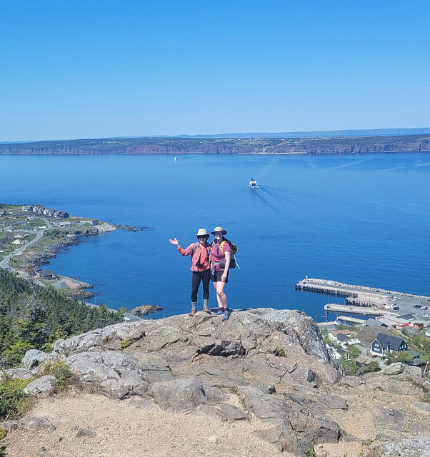
Long Shore Path is an interesting section to write about. There’s currently 3 trails on the northwest side of the Avalon peninsula between Topsail and St. Francis: Long Shore, Piccos Ridge, and White Horse. All 3 trails have been around for a while, but only officially opened in the Spring of 2022. I’ve already done Piccos Ridge, and White Horse has a reputation as a challenging trail, so I decided to tackle Long Shore Path while I was home in June.
It’s an interesting section of trail because it’s technically the start of the East Coast Trail. The trail is always changing and evolving, so it may not stay this way forever, but it currently runs north from Long Shore Trail to Cape St. Francis at the far north peak of the peninsula, where it then turns south all the way to Cappahayden.
The reason I say that Long Shore is interesting is because it’s marked as a 17km long section of trail, but there’s ~4km of road walking in the middle of it. Typically sections of road this long aren’t included in the trail sections (though I believe they are included in the overall length of the ECT, as you would have to walk all the road sections if you did it as a true thru-hike). I find it a bit odd that they decided to include so much road walking in Long Shore Path instead of just breaking it into 2 sections. I didn’t want to do 4km of walking along the road, so I opted to do the trail in 2 sections over 2 days. So I guess I technically haven’t done the entire thing, but I’m going to count it as close enough.
I did the first section in late afternoon with Emily after she got off work one day. We drove out to Topsail Beach and hiked the first 4km of coastline to St. Thomas and back for a total of 8km. The trail starts right at the beach in Topsail Rotary Park and is primarily through the woods the entire way. Generally I don’t love long wooded sections, but I didn’t mind this part because it’s pretty sparse forest and you can still see the coast through the trees. The trail is a little bit technical, with tree roots and rocks, and undulates up and down.
When you get to the end of the trail, you can take a left to walk down Lorry Road to the beach at St. Thomas. It’s a quiet and lovely beach that I’d never been to before and it makes for a nice end destination. It was overcast when we started the hike, but we sat on the beach for a while as the sun started to break up the clouds. It took us about an hour to hike the 4km and we had a few snacks before turning around to hike back. The sun properly came out on our return, which really brightened up the trail.
The following day I returned with Seth and his parents to hike the rest of the trail. After St. Thomas is the 4km of road walking to St. Philips Beach, followed by another 9km of hiking to Portugal Cove. We parked one car in St. Philips and then started from the trailhead in Portugal Cove to hike backwards. The first part of the trail out of Portugal Cove is another odd section because it doesn’t actually follow the coastline at all. Instead, you hike up behind Portugal Cove to a series of lookouts along the bluffs. It doesn’t feel very East-Coast-Trail-like, but it’s beautiful nonetheless.
It’s about 225m of elevation gain to the top – we didn’t find it too challenging, but if you don’t like climbing you may want to take your time. There are some excellent views of Bell Island from the top as you hike along the bare rock before descending to Beachy Cove. The descent isn’t very nice as you go through a huge section of blowdown, with tons of knocked over and destroyed trees. It’s not hard to follow the trail as the debris has been cleared, it’s just not very scenic. Once you reach the bottom, you hike out along an ATV road and then swing left on the road for a few hundred metres before turning right to go down to Beachy Cove.
Beachy Cove is easily accessible from the road, but it’s another beach I’d never been to that is really lovely. There’s a big waterfall flowing down to the ocean and the river can be a bit challenging to cross when the flow is heavy, but if you’re able, there’s a picnic table on the other side where we stopped for lunch. To get to Beachy Cove was ~6km, then there’s another ~3km along the coast to get back to St. Philips. This section is very similar to the 4km between Topsail and St. Thomas in that it’s mostly in the trees and undulates up and down (though I’d say it’s more challenging than the Topsail section).
The only tricky part of this trail is when you reach Goat Cove. There’s a creek flowing down to a small pocket beach, so you have to descend down a sketchy rope section to the beach. From what I’ve heard, there used to be ropes on both sides of the beach, but there are stairs on one side now, so I wouldn’t be surprised if a second set of stairs is added in the near future, which would make this trail much more accessible. As it is now, it is a particularly long rope section that is manageable, but not easy. I’d recommend bringing gloves for the rope and taking your time.
We didn’t have quite enough water for the entire hike, but fortunately I’d brought my water filter, so we filled up with fresh cold water before continuing on. The rest of the trail isn’t particularly difficult and we enjoyed the glimpses of sun through the trees while still enjoying the shade.
So it’s a bit of a complicated trail with so many sections. I’d definitely recommend doing it in 2 sections to skip the road walk, but if you wanted, you could even do it in 3 sections as return hikes, which is what Emily ended up doing. I didn’t expect to like it as much as I did with so many forest sections, but it’s actually quite scenic (especially the views from the hill in Portugal Cove) and I loved hiking to all the little beaches along the way. Whether done as 1 long trail or several sections, it makes for a really nice hike.