Dog Sledding and Other Adventures

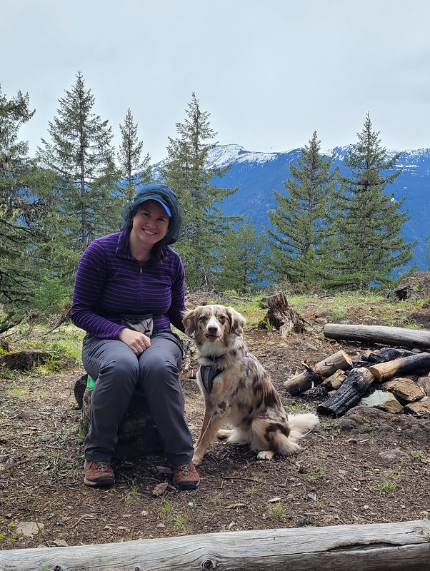
On our second day in Yllas we made another attempt at the ski hill. This time we drove around to the Yllas side since there are more chair lifts. It was still windy, so we were disappointed that the top half of the mountain remained closed, but we decided to go skiing anyways. It was mid-week, so fortunately it wasn’t too busy – we had to wait in line at most lifts, but given that half the mountain was closed, it could have been a lot worse.

Skiing in Finland is a very different experience from skiing in Canada. It’s not a very large mountain and it’s incredibly bare and exposed, so the skiing is not as adventurous. If you like groomed runs, it’s a decent mountain, but there’s almost no ungroomed terrain, so it can be a bit boring. The mountain is deceiving because it looks like there is un-skied powder between each exposed run, but because of the climate, the snow off-piste is very crunchy and bumpy – not fun for skiing.

20230228_125152

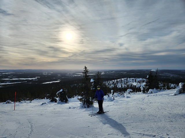
But the biggest difference is the lifts. Yllas had one high speed chair lift going half way up the mountain and one (closed) gondola going to the top. Besides that, it’s almost entirely T-bars. We also skied a second resort in Levi and it was the same. None of the terrain is very steep and because the mountain is so bare, you can ski down any face, so I guess it’s a lot cheaper to install a ton of T-bars, with each one only servicing a couple runs. It wasn’t that big a deal, but it does make for a tiring day when you don’t get to sit on the chairs because then you are constantly on your feet.

So it wasn’t my favourite mountain to ski, but it was definitely an experience! We skied all over the mountain in the morning, then after lunch we managed to find one glade run on the far side of the hill, which ended up being our favourite, so we skied that one a few times. There’s a lookout on the way back to Akaslompolo and we timed our departure to catch the sunset from the viewpoint. We didn’t see that many sunsets in Lapland, but the ones we did see were very beautiful. The sky turns purple and pink and reflects off the snow.

20230228_145127

On our last day in Yllas we opted to do a dog sledding tour. I was really on the fence about it because they’re not cheap and you can do them in Canada. But I went to Banff last winter and opted not to do one, so I figured now was the time and booked a half day tour with Rami’s Huskies.

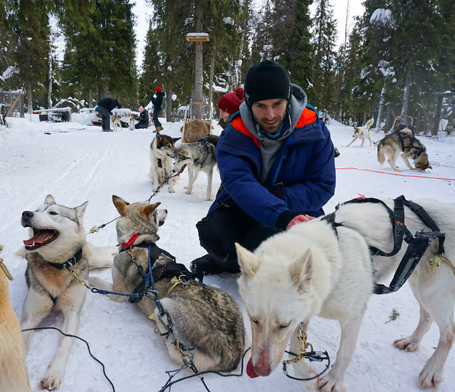
Rami’s is located just outside the National Park and we arrived to the predictable symphony of screeching huskies. We didn’t really know what to expect, but we were excited to learn we would sledding in pairs of two, which meant we would get to drive our own sleds! We got a quick lesson in the basics: hand signals, stopping, how to take turns, and when to slow down; and then we prepared for our 16km run in the National Park, with a lunch break at the half way point. The sled is just big enough for one person to sit in it and one person to stand at the back. The person on the back is the driver, so we decided Seth would steer first while I took photos from the sled.

20230301_102225
20230301_102416

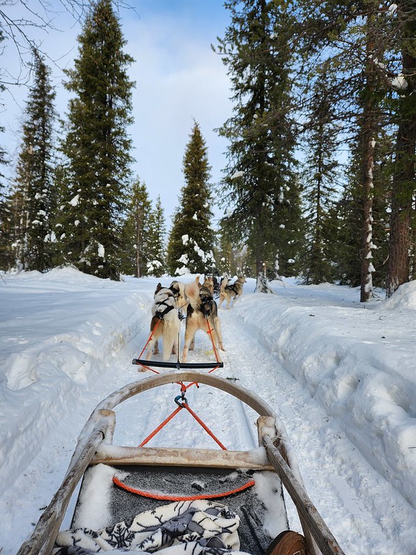
There was about 10 of us on the tour, plus two guides. Each team had 6 dogs, so there was a whopping 42 dogs in our party! When you’re dog sledding in the wilderness, you direct the dogs verbally on where to go, but we were following a track the entire time, so the dogs pretty much just follow each other and the track, so it’s easy to drive. You just need to use the brake whenever the person ahead of you signals because you don’t want to run into the team in front of you.

It’s a bit of a slow start at first because the dogs are extremely excited to run and there’s a very sharp turn early on that the guides want everyone to take slowly. We had a few stop and starts, which are challenging because the dogs were very restless, but eventually we got into the groove and no one fell off their sled the entire trip, which is a bit of a rarity. Seth had his work cut out for him when we kept stopping because the team behind us had a very excitable lead dog named Ginny, and she would get too close to Seth whenever we’d stop and nip at his butt to try and get him to keep going. Our team was a bit slow, so eventually the guides swapped Ginny into our team and we went a lot faster after that!

PSX_20230307_185753
PSX_20230330_071823

We had so much fun on this trip! I wasn’t really sure what to expect, but we were thrilled to drive the sleds ourselves and what left the biggest impression on me was how much the dogs love to run. They are loud when you arrive because they are already hooked up to the sleds and they can’t wait to get going. Around the 8km mark we stopped for a break and the dogs mostly settled down for a rest, but as soon as we started getting ready to go again, they were up and eager to keep running.

We had what I can only call a boil-up for lunch, which is popular in Newfoundland (the similarities continue). We got a little fire going to make tea and the guides roasted sausages for us to snack on with some biscuits. We had the chance to question them on the dogs and learned a lot about the sledding industry. At Rami’s, the dogs will run about 32km a day, 5 days a week, at their peak age and health. They’ll either do two 16km rides (like ours), or a 16km ride in the morning, followed by a 10km ride in the afternoon, and a 5km ride in the evening. They regularly swap out which dogs are in which teams, but the dogs all have distinct personalities and some won’t run together, while others will only run with certain dogs, and some will only run as lead dogs.

PSX_20230330_071648

It takes about 2 years for dogs to mature, so they don’t work full time before then and are mostly in sled dog training. Once they get older, they reduce the number of kilometres they run per week, but they never fully retire the dogs for their mental health. Huskies are an eccentric breed and I can see how it would drive the dog nuts to not run at all after a lifetime of it. Rami’s doesn’t do dog sledding races, only tourism, and they have about 75 dogs in their kennel, which is considered small. Some kennels have up to 450 dogs!

So if you ever find yourself in Lapland, or even anywhere in Canada that offers dogsledding, I would highly recommend it! We really loved it and I wouldn’t hesitate to go again – now I just need to do some research on where I can go in BC!

20230301_135803
20230301_133756

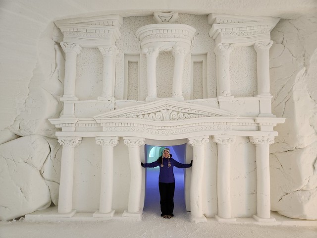
Rami’s is close to the Lapland Hotels Snow Village, so after we finished our tour we decided to drop by the hotel. It’s a hotel compound made entirely of snow, so it gets re-constructed every year. I think the layout remains the same year after year, but the village is filled with tons of snow sculptures and those change every year depending on the theme. It seems like their most popular year was when they did a game of thrones theme, but when we visited they had an around the world theme and had sculptures of iconic monuments from around the world.

The village comprises of a snow restaurant, a normal restaurant, an ice bar, and a hotel. During the day the hotel has a cover charge to view, so it operates primarily as more of a gallery. There’s about a dozen different themes rooms with varying numbers of beds. Since no one stays there during the day, we were a little bit confused about how it worked because the village is open to visitors from 10am to 10pm. But if you’d like to stay in one of the snow rooms, they are available purely for sleeping starting at 10pm. So basically you check in, sleep in the room, and get hurried out in the morning, so it wouldn’t be my choice, but to each their own! We enjoying viewing the sculptures and then hit the road for our next stop in Levi!

20230301_135016

Tikwalus Heritage Trail Backpacking Trip

Despite the high levels of snowpack hanging around in the mountains this year, I had a good start to the season and got in a second backpacking trip the first week of June. I find Spring backpacking challenging because of the limited number of trails with campsites that are snow free, so me and Carolyn have been trying to branch out to find new trails. This was made somewhat more challenging because we wanted to bring our dogs with us (and even fewer trails are dog friendly), but fortunately Tikwalus Heritage Trail fit the bill!

Tikwalus is located about a half hour north of Hope on Highway 1, just before you reach Hells Gate. As we were driving up there we realized that neither of us had done any hiking in this area and I couldn’t recall ever driving the highway since I’ve lived in BC (though I did it once as a tourist before I moved here). It’s exceptionally beautiful driving along the steep walls of the Fraser Canyon and it doesn’t seem to get that much hiking traffic. Despite not arriving at the trailhead until noon, we were only the third car in the lot! A very promising sign for me since Sadie can be reactive to people and dogs.  

20220528_125416

At 6.5km to the campsite, it’s not an overly long trail, but it is very steep and you gain almost 800m in the first 4km. We took our time going uphill and the dogs had a blast alternating between playing with one another and guiding us up the trail. Sadie is almost 2.5 years now and is an Australian Shepherd, which is a very high energy dog, so she had no problem with the hike and carries her own food and equipment in her Ruffwear pack. Jasper is still a puppy and less than a year old yet, so he was freeloading off Carolyn until he gets old enough for a pack. He got a bit tired early in the hike from the uphill, but he also has a lot of energy and bounced back very quickly once he got used to the climbing.  

20220528_153208

As the name suggests, Tikwalus is a heritage trail and covers both indigenous and colonial history. The trail has been used for many, many years by the Nlaka’pamux for hunting and gathering and there are several culturally modified cedars along the trail. In later years, the trail was used as a trade route through the Cascades by the Hudson’s Bay Company. There are several placards along the trail providing lots of information about the history of the trail, so it made for an educational hike and a nice respite from the uphill monotony on the way in. About halfway up there’s a beautiful viewpoint looking out on the surrounding mountains.  

20220528_140213

Once you get to the top of the steep section (~4km), you’ve done most of the elevation gain and the trail branches into a loop around the summit. If you do it as a day trip, it’s about 13km round trip. It’s mostly flat around the top, so we decided to take the slightly longer lake route to shorten our journey for the following day. Unfortunately there’s not a ton of views around the lake route, but there is a huge viewpoint on the other route. It was clouded over on day 2, so we never got to take advantage of the viewpoint, but it’s still quite scenic at the campsite, so it wasn’t that big a deal. Just something to note if you’re in a similar position as us with the weather. The viewpoint route does go along a narrow spine though, so if you have any issue with heights, the lake route felt a bit safer.

It took us about 3.5 hours to reach the campsite. We didn’t take any long breaks, though we did stop to get water when we crossed over a fast flowing creek on the way up. This was a really good choice because the water options near the campsite are not ideal. There are two creeks on either side of the campsite. I would say the option on the lake route is the better of the two. It’s closer to the campsite (maybe a 10 minute walk?) and it has a decent flow rate. The placard said there used to be a cabin in this area in the past because it was used as a water source. The second option is on the viewpoint route.

20220528_164759

It’s a bit farther (maybe a 15 minute walk?) and it’s not as fast flowing as the other one. To be honest, neither are great, so make sure you bring a filter, I wouldn’t want to rely only on water tabs. I’ve read in some comments online that people get water from the first lake, but I would definitely avoid – it’s very still and a terrible water source. Just walk a bit further to use either of the creeks.

There were two other groups at the campsite when we arrived, but it’s very large and we had no trouble finding a good spot to pitch our tent away from other people. We were joined later by a few more groups, but at no point did it feel crowded. The trail seems to be used primarily for backpacking. We didn’t see a single person on the way up or down, so it seems like most people who go up there plan to stay the night. It’s a mostly forested trail and campsite, but there are some really nice views looking out over the mountains.

20220528_164804

We had really nice weather on the way up and it threatened rain in the early evening, but mostly held off. Campfires are allowed at this campsite and there were several established rings around, so we collected wood debris from around the site and got a small fire going. I’ve done a whole post on responsible campfires, so make sure to only take dead wood and to avoid harming any natural habitat. Fires aren’t permitted in so much of the backcountry (and even when it is permitted there’s often a ban), so it was really nice to have one! We forgot a firestarter, but Carolyn worked some magic to get one going.  

20220528_190008
20220528_165001

The rain finally moved in around 8pm and we decided to call it an early night. It was really just a bit of drizzle, but neither of us wanted to sleep with 2 wet, stinky dogs. However, it was still light, so it took the dogs a while to settle down and we did some reading before falling asleep early. Unfortunately, the dogs get up with the light, so they had us up and awake at 6am. It rained on and off throughout the night, but was mostly mist when we got up. We had a quick breakfast and then packed everything up and were back on the trail shortly after 8am. Quite early for us!

I thought it was going to be a brutal walk down based on how steep it was, but it ended up not being too bad. We saw nothing but clouds from the viewpoint on the return loop, but they lifted enough for us to get a misty view of the mountains at the halfway viewpoint. We finished the hike around noon and stopped into the General Store on the way back to Hope for lunch.

20220529_095612

Overall, it’s a pretty understated hike. It’s mostly in the trees and it is quite steep, but we really enjoyed it. It’s very green in the Spring and we loved that it wasn’t crowded. The large campsite gave us lots of space and we liked the rare opportunity to have a campfire. It was a great choice for taking the dogs and we loved exploring a new part of the region that we’d never been to before and learning a little bit about the history of the area. Would definitely recommend if you’re looking for an early season hike and don’t mind a climb. It is tiring, but it’s not a technical trail, so I think it would be good for beginners looking to build up their stamina and abilities. It has both an outhouse and a bear cache and you can bring your furry friends!  

20220529_104025

Hiking Slesse Memorial Trail

Slesse Memorial Trail has been on my bucket list for a while, but the access road is a little bit dicey so we’ve been waiting for the right opportunity. In late September, me, Seth, and Brandon decided to make a go at it.

Slesse Memorial is a 12km out-and-back trail located off Chilliwack Lake Road. After having driven the access road, we wouldn’t say that you have to have 4WD to get to the trailhead, but high clearance would definitely be an asset. You won’t get there in a car, but potentially in an AWD SUV. Personally, I wouldn’t take my Hyundai Tucson out there because I’m not comfortable driving in terrain with water bars, but Brandon thought you could probably make it there in one if you wanted to try.

20210925_094750

Either way, we had no trouble getting there in Brandon’s 4runner. The nice thing is it’s not a long access road. Cheam Peak is located in the same area and it took us about an hour to drive 9km on that road – the access to Slesse probably only took us around 15-20 minutes. There’s a small parking lot at the end and there are two branches from there. One branch continues on in the same direction as the road coming in, and the second branch is on the left and continues up a rocky narrow road. The second branch that goes up continues on to Mount Rexford and my GPS indicated that we needed to continue up that road about 600m and then take a right branch onto the old Slesse Memorial Trailhead. I say “old”, because Brandon’s GPS showed a second trail leaving on the straight branch out of the parking lot, which we later learned is the “new” trailhead.

20210925_104055

I recommend taking the newer trailhead (the right of the two forks). Either will get you there and they do meet pretty early on the trail, but the newer trailhead is slightly shorter, easier, and more well maintained. We missed the old trailhead on our first pass and had to double back to find it tucked in the woods.

The first half of the trail meanders through the forest and isn’t very difficult. There are some tree roots to step over, but it’s not overly technical. Shortly before the memorial plaque, you pop in and out of the woods and get a few glimpses of Mount Rexford across the valley. We went in late September and the trees were just starting to change colour. We were a bit too early for full colours, so I’d recommend early October instead.

PSX_20210929_205451

The memorial plaque is located around the halfpoint of the hike and has a beautiful view looking up towards Slesse Mountain. The trail is called Slesse Memorial Trail because a commercial jet crashed on the side of the mountain in Dec. 1956, killing 60+ passengers and crew. The plane was flying from Calgary to Vancouver when it disappeared and it wasn’t actually found until 5 months later when a climbing crew accidentally spotted it on the side of the mountain. Due to the challenging locating, the bodies were never recovered. You can’t see the crash along the trail (at least we didn’t), but some of the debris has been collected at the top of the trail. I’m not sure at what point this was done, but these days there are signs indicating not to do this.

HOP_6344

We came for the view versus the memorial, but it was very interesting and we spent a lot of time thinking about it, making it a bit more of a somber hike. After the plaque, the trail gets a lot steeper. I thought we might need to do some way finding on the trail, but it’s easy to follow, just steep. There were a lot of old blueberries along the trail, so I could see it attracting bears, but on this occasion the berries only attracted Sadie. She discovered them growing there and wouldn’t stop picking and eating all the berries! It was very cute.

20210925_135450

In all it took us just over 3 hours to get to the top. It’s an interesting trail because it doesn’t go to the top of the mountain, but rather the base of it. A lot of the mountains in this area are forested, but Slesse is sheer rock with no vegetation growing on it. It’s very steep, so I’m sure it attracts climbers, but for hikers, the trail ends at the base of the mountain. There’s a beautiful 360 degree view and you can climb up a bit further if you’re feeling adventurous. There’s a long flatter section of rock, with a glacier coming down one side and the sheer rock face at the back. I say “flatter” because the rock is still a lot steeper than it looks. Me and Brandon explored up a bit further, which has a gorgeous view looking back towards Rexford.

20210925_135652

Be careful where you explore though, it was a surprisingly hot day for late September and the glacier was on the move while we were there. At one point there was a very loud rumbling and we watched as a big snow patch at the bottom of the glacier slid down part of the mountain. So we stayed away from that section and explored directly under Slesse, where there was still a bit of snow, but much less and not as steep.

PSX_20210927_223317

The steep uphill section does make for a slow descent on the way back. We left around 2pm because we didn’t want to get stuck hiking in the dark. We inched our way down the top section, but were able to pick up the pace a bit once we got to the flatter bits. It’s a pretty narrow trail, so it can be a bit tricky passing people. We only saw 2 other people on the way up, but passed a handful of people on our way down.

HOP_6383

Overall it was a nice hike. It was a lot more forested than I was anticipating, there’s a few peak-a-boo viewpoints, but not too many views until you reach the top. If you have the time to explore at the top though, there’s quite a bit of open terrain. We finished the hike around 5pm and still had lots of daylight left, but I’m glad we turned around when we did because the sun goes down over the mountains on this trail pretty early, so it was still quite dark hiking back through the trees at the bottom. I did really like the hike and would love to return and do more hikes in this area!

HOP_6405