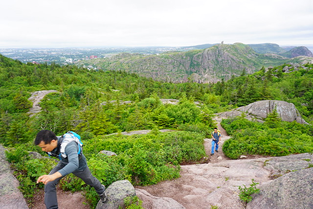
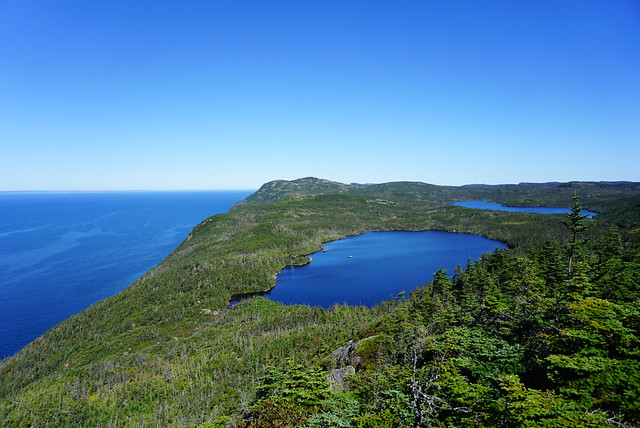
Mudder Wet Path is a funny little part of the East Coast Trail in Aquaforte. If you’ve never heard of it, I think it’s because it was officially added to the Spurwink Path, which I don’t really like because Spurwink is already a long section of trail, so I think a lot of people skip the Mudder Wet section of it when they do it (which was the case for me when I did Spurwink). My ECT map collection is quite old, from when Mudder Wet Path was considered it’s own section of the trail, so I did a double header in June 2023 and did Mudder Wet and Caplin Bay Path on the same day, since they’re both pretty short.
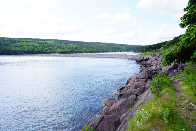
The Mudder Wet section runs from Aquaforte to the trailhead of the Spurwink Path off the highway. It’s under 2km if you do it one way, but it can be extended up to 5.5km if you do it as a round trip with some of the side trails (which is how I did it). I parked in Aquaforte and hiked out to the beach at Little River where the Aquaforte River meets the ocean. The official trail does a big roundabout back to the highway to hike around the ravine where Little River comes down, before returning the beach on the other side of little River. Then you can continue up along the river to the highway where you connect with Spurwink.
I hiked down to the beach on the way in and found a side trail that hikes up along Little River to a waterfall. It’s a nice little hike – I was hoping it would connect back to the official trail, but because of the steep walls of the ravine, I had to hike back to the beach and do the full roundabout. I continued the long way and did the whole trail back to Spurwink, but on the way back I decided to try and save myself some time. I hiked back down to the beach at Little River and crossed the river instead of hiking back up around it. The river was flowing low enough and the tide was way out, so I was able to cross without taking my shoes off. So it can be done, but I’m not sure how frequently. I think if it was high tide it might not be crossable at all.
So it’s a small little trail, but I ended killing more than an hour and a half there with all the exploring. I decided to include my GPS track below for reference since the descriptions can be pretty confusing. I wouldn’t put this trail very high up my list of trails to do on the ECT, but it was one I needed to do to complete the trail and I had a nice time hiking it solo. There are really nice views of Aquaforte Harbour.
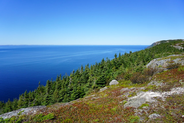
I haven’t hiked Deadman’s Bay Path since 2019, but it is one of my favourite trail sections on the ECT and I’ve done it 3 times. Most recently I did it with Lien and Brandon when they visited Newfoundland for my wedding, but I’ve also solo hiked it in the past. This section of the trail runs from Fort Amherst to Blackhead and is approximately 10.5km in length. I feel like it has a bit of a bad rep because of the steep climb out of Fort Amherst, but I think it’s unjustified because it’s only a steep climb and the views from the top and along most of the trail are really unparalleled.
You can hike the trail in either direction, but I’ve always done it from Fort Amherst to Blackhead. If you try to logic that the other direction will avoid the steep climb, you’ll just have to do it out of Freshwater Bay instead, so either option is basically the same. I definitely recommend 2 vehicles for this trail since you won’t want to have to turn around and go back the entire trail, but given the proximity to St. John’s, it’s easy to get dropped off or picked up on one end. If you’re looking for a shorter day, you could also exit at Freshwater Bay or just turn around at Freshwater Bay and only do half the trail. I haven’t done the Freshwater Bay access trail in years, but I believe it’s about a 45 minute walk.
If you start in Fort Amherst, you can visit the lighthouse and get the climb out of the way early. It only takes me about 15 minutes to climb up to the top of the bluff and once there, you’ll have an amazing view of Signal Hill and downtown St. John’s. One time I started the trail around noon and ate my lunch once I reached the top so I could enjoy the view a bit longer. If you don’t want to do the whole trail and are just looking for an hour long walk to get some exercise, I suggest doing the climb up to the top and just enjoying the view before turning around. It’s a great workout and will help build up your stamina.
After that, the trail meanders along the top of the cliff without too much up or down. It goes in and out of the trees and past a few water holes, all with fantastic views of the coastline. Right around the 4.5km mark you start the downhill section into Freshwater Bay (which is the worst uphill part if you go the opposite direction). Freshwater Bay is another lovely short hike on it’s own if you want to park off Blackhead Road on the way to Signal Hill and hike in. It’s marked by the long strip of beach that separates Freshwater Bay Pond from Freshwater Bay – I’ve never swam in the pond myself, but Emily has and it makes for a good cool down on a nice day.
I had a minor breakdown at Freshwater Bay when I hiked it with Lien and Brandon because I forgot sunscreen and was petrified of getting a sunburn or awful tan lines before the wedding, but fortunately a kind stranger happened upon us at the exact right moment and lent me some! Freshwater Bay is located at ~5.5km, so it makes for a good halfway point to stop and have lunch if you’re doing the whole trail.
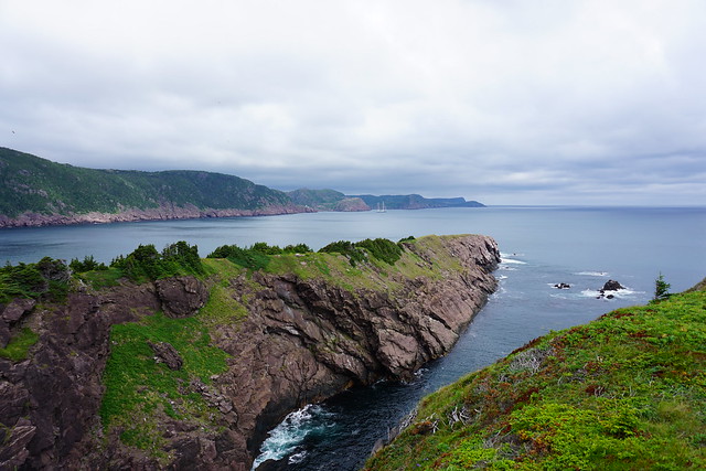
After crossing the beach, you head back up into the woods and traverse along the edge of the bay. The trail comes out of the woods at the end and I recommend following the trail out to the viewpoint on Small Point for amazing views back to St. John’s and out to Cape Spear. After Small Point the views are more about Cape Spear than St. John’s and the trail winds it’s way around Deadman’s Bay before finally heading into Blackhead. The trail is pretty exposed walking into Blackhead, so gets pretty windy and you can get hit with ocean spray on a particularly blustery day.
If you’re feeling particularly adventurous, you can continue for another 4-5km to Cape Spear on Blackhead Path. I did this once when I was hiking solo and I was ahead of schedule for when my Dad was going to pick me up. It’s not a difficult trail, but it will significantly lengthen the hike, so most often I just end at Blackhead. I’m about 60% through the East Coast Trail to date, but Deadman’s Bay Path remains one of my favourite trails, and given it’s proximity to the city, I definitely recommend!
Piccos Ridge is the most recent section I’ve done on the East Coast Trail. It runs from Portugal Cove to Bauline on the west side of the northern Avalon Peninsula. The trail has been around for many years, but it is one of the newer trails and the ECT association has been doing trail expansion on the northern side of Bauline Line recently as well.
At 14.5km, Piccos Ridge is one of the longer trail sections and it has a bit of a reputation of being one of the more challenging trails due to the steep uphill at both ends of the trail (and throughout). Emily hates this section and when I was out for dinner in July with my family, my cousin started bragging about how he had done Piccos Ridge and therefore could pretty much do any other trail. I was skeptical that Piccos Ridge was the pinnacle of Newfoundland’s challenging hikes, so I figured I’d bump it up my bucket list. I ended up having to make a surprise trip home again in September and decided to give the trail a try to see if it lived up to my cousin’s assessment.
I will admit, Piccos Ridge is harder than some of the other trails of similar length, such as Stiles Cove. I didn’t find it as challenging as some of the other sections I’ve done (the Spout kicked my ass), and I’ve definitely done more strenuous mountain climbs in BC, but I can definitely see where it gets its reputation. It is very steep climbing up the trail out of Bauline and there is a fair bit of undulation across the rest of the trail, so it feels like a lot of climbing throughout. I read a few reviews on AllTrails before going and they all strongly recommended starting the trail in Portugal Cove and going north because the last stretch into Bauline “was very difficult to even climb down it”. Friends, can I let you in on a secret? It is so much safer to go up steep sections than down. Also, I have bad knees and I prefer going up over going down, so I decided to buck the trend and start my hike in Bauline.
It took me about an hour to get from Bauline to the first lookout. That is the most strenuous part of the hike, so I was glad to get it over with early and it got much easier after that. I went on this hike solo and it was interesting because I hiked shortly after Hurricane Larry had passed through Newfoundland, so there was a lot of blowdown along the trail. I debated a few times if I was maybe getting myself into trouble climbing over the trees and would potentially get stuck somewhere further along the trail, but the first section was the worst and I didn’t encounter too much more downfall after that.
From the first lookout, you hike back down a little bit before ascending up to Piccos Ridge, which is the highest point along the trail. Even though it was getting later in September, I encountered quite a few berries in this section, particularly partridgeberries! You continue along the ridge for awhile before making a big decent through the trees towards several ponds. There is an unofficial campsite located at Brock’s Head Pond at about the 8.5km mark. I could only see room for 1 or 2 tents in the trees, but there is a bit more open space just past the pond at the river, which is the water source. There are no facilities.
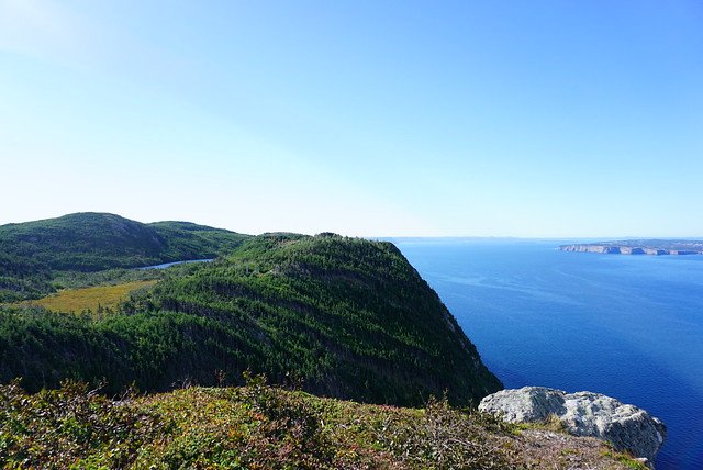
There’s one last uphill climb after the campsite, but then it’s smooth sailing after that! I think this was my favourite section of the hike because it’s all wide open and barren at the top. Piccos Ridge has a lot of different viewpoints, but large parts of the trail are in the trees, so I love hiking along the barren rock with the Atlantic stretched out alongside you. The view from this trail is into Conception Bay, so on a clear day you can see over to the other side of the peninsula and there are great views of Bell Island.
The rest of the trail is a steady downhill, so I can see how it’s a strenuous trail from either end, though the uphill is more gradual on the Portugal Cove side, which is why most people prefer that direction. Unfortunately I didn’t end up making it quite to the end of the trail. A few things came up and I decided to get off the trail a little early to try and make another appointment. Shortly after the 12km mark (so 2km before the trailhead in Portugal Cove), there’s a branch that exits off to Blast Hole Pond Road. The very top section of the road is gated, but then it’s gravel road which turns to asphalt. My knees were really bothering me, so I figured this would be an easier and quicker exit along the road, which was definitely the case. Mom was going to pick me up at the top, but I ended up powering it down the entire road before she got there. So overall I did the same distance, but skipped the last 2km to the official trailhead.
I would definitely go back sometime and hike up from the Portugal Cove side just to get the views. The highest view on that end is at 4km, but there’s views along most of the trail here, so you could hike as far as you want and then turn around for a shorter hike. In total it took me 5 hours, but I didn’t stop very much and I would recommend more time if you’re in a group or want to pick some berries. I did really like this section of the trail though considering Emily has been bad-mouthing it to me for years. There’s some ECT sections I wouldn’t want to do twice, but this definitely isn’t one of them!