ECT Series: Flamber Head Path

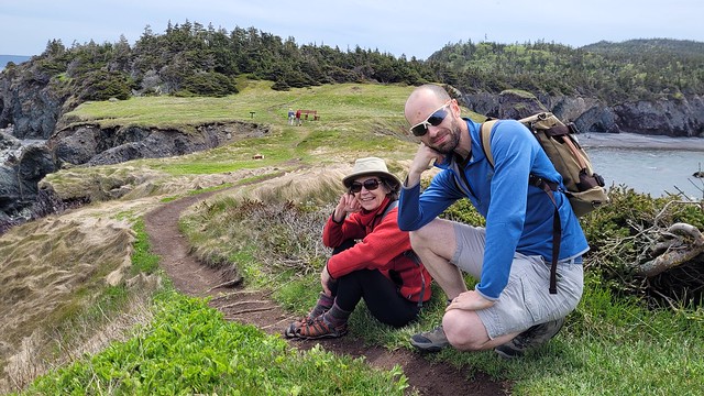
I hiked Flamber Head Path for the first time in July 2023. Flamber Head seems to be a relatively popular section of the East Coast Trail, so I’m surprised it took me so long to finally hike this section. I was hoping to do the 14km section as an overnight trip, but the weather and dates didn’t really line up, so I opted to day hike it with Mom and my friend, Sean.

Flamber Head Path runs from Brigus South to La Manche. The trail maps are a little deceiving, because it lists the trail as 12km in length, but doesn’t account for an additional 2km of hiking from the parking lot to La Manche suspension bridge. If you want to extend the hike to Bauline South, you could knock out 2 sections of the trail at once and avoid the access road. I’ve already done the section from La Manche to Bauline a few times, so we just hiked back to our car.

20230707_103336

We started the hike at Brigus South and it took us 6.5 hours in total to complete the 14km hike. We did all the side trail viewpoints, stopped at Flamber Head for lunch to do some whale watching, and went for a swim near the bridge. The net elevation gain on the hike is only like 70 metres, but there is a lot of up and down, so the total elevation gain is actually over 400 metres, which definitely adds up!

The trail out of Brigus South is nice and scenic along the coast, so it doesn’t take too long to reach the campsite, which is located at the 3.5km mark. It would make a good overnight trip after work on a Friday night in the summer, because you don’t have to walk too far on the first day. Unfortunately, the campsite has really fallen into disrepair. There’s a lot of sketchy trees that look like they’re about the come down, and almost every tent pad has boards missing.

20230707_104137
20230707_120715

I found this to be the case at the Cape Broyle campsite as well, which is really sad, because I don’t think the ETCA has been keeping up with maintenance for the campsites. To be fair, it’s a very long trail that needs constant maintenance every year in clearing blowdown and repairing boardwalk, so I know they are likely strapped for cash and time since Newfoundland summers are very short. I know the ECT sees a lot more traffic from day hikers than campers, but I think the ECT could really turn into a cool thru-hiking destination if the campsites were better kept and more plentiful. At the moment, it’s a more rugged experience, which is fine, but a little sad to see the limited number of campsites in such rough shape.

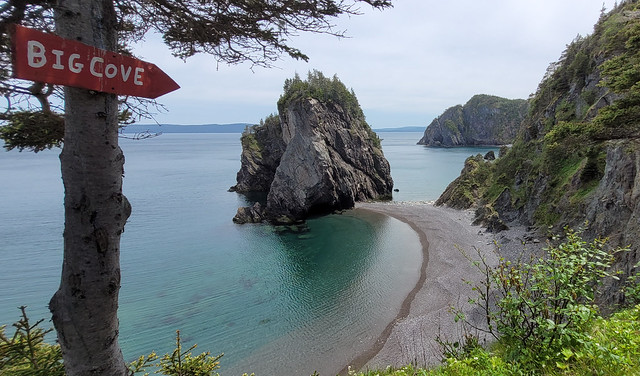
The campsite itself is in the trees and not very scenic, so I think people have taken to camping on Flamber Head instead, which is another 1km past the campsite. There is a stream with drinking water just past the campsite, which poor Sean fell in trying to cross, so it’s easily accessible from either the campsite or the Head. The main issue with camping on Flamber Head would be the wind, as there’s no shelter out there. So I’d only attempt it if I had a robust tent and the forecast was good.

20230707_121853
20230707_124945

The view from Flamber Head is gorgeous though! We hung around for a while, eating our lunch (including mom’s homemade cream-cheese brownies) and watching for whales. I’d say it’s probably the best viewpoint on the trail, but there are nice views at Gentleman’s Head (km 7) and Gull Rocks (km 9) as well. Gull Rocks requires a bit of extra hiking uphill, but it’s a stellar (albeit windy) view of the coast. Me and Mom hiked up it, but Sean was having a rough day, so he waited us out at the bottom.

Hiking on the East Coast Trail can be incredibly draining, because there is a lot of up and down and the trail can sometimes be pretty technical. Overall, the constant uphill hiking in BC has aided me a lot in my endurance for hiking on the ECT, but exercise caution, because it is a very different type of trail and the variation can wear you out. When me and Emily day hiked the Spout, we pretty much hobbled out the trail at the end.

20230707_135954

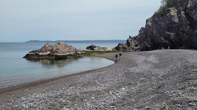
The La Manche suspension Bridge is located at the end of the official ECT section and is a fun highlight of the trail. The suspension bridge and surrounding stairs underwent a full upgrade in 2023, so they’re in great condition now! But the highlight of this section for me is swimming in the little river pool before it discharges to the ocean. I’ve swam here on several occasions and even though it was a chilly day, the water was super warm! Mom joined me and we had a nice little refreshing soak in the pool before doing the final 2km back to the car.

We nearly killed Sean on this hike, but I had a great time exploring a popular part of the trail that I’d never done before. I’d definitely recommend giving yourself a full day to explore, because there are lots of different highlights along the trail. Bring your binoculars for the viewpoints and your swimsuit for the river!

20230707_160333
20230707_161329

ECT Series: Biscan Cove Path

I needed a bit of a writing break to start the year. I had a lot of summer and fall adventures to write about, but it’s been pretty low key for me in December and onwards. I was hoping to go on some winter adventures through the holidays, but it’s been a very late start to winter in BC and to be honest, I needed some rest time. So mostly I spent my holidays holed up inside doing jigsaw puzzles and listening to audiobooks.

To start the year, I decided to expand my Newfoundland series for the next few weeks since I don’t have a lot of winter activities to write about at the moment. I’ve been working on completing the East Coast Trail for several years now and I think I might be in a position to finish it this year, so I figured it’s a good time to get caught up on some of my trails!

20230627_111722

I first did Biscan Cove Path back in 2016 and at that time, the road to Cape St. Francis was in really rough shape and Biscan Cove Path itself took a lot longer than I anticipated. I returned to the trail in late June 2023 and generally had a much better experience on the trail than in 2016. Biscan Cove Path runs from Pouch Cove to the lighthouse at Cape St. Francis, which is the most northerly point on the East Coast Trail. At one point, I think it might have been the start of the entire ECT, but the trail has since wrapped down the other side of the avalon peninsula towards CBS.

This was a bit of a tricky trail for section hikers because the paved road pretty much ends in Pouch Cove and the gravel road to the lighthouse used to be in really terrible shape. But it was recently graded, so it’s much easier to do this trail with 2 cars now. The first time I did it, I skipped the extra 1km to the lighthouse and hiked from Biscan Cove to Pouch Cove. On my more recent visit, I started in Pouch Cove and generally liked the experience more because you can end at the lighthouse, which is a really nice place to whale watch while eating your lunch.

20230627_125022
20230627_124852

You can park your car next to the field at Memorial Park in Pouch Cove and then walk up the road to the trailhead at Baldhead Road. It’s just over 8km from Pouch Cove to Cape St. Francis and it took me and Mom a little over 2.5 hours to do last summer. We made a pretty quick pace with just the two of us, but it can be a deceiving trail. When I did it the first time, it took us more like 4 hours to complete, but it was with a much bigger group and we picked a lot of blueberries.

I actually like this trail a lot though. There’s quite a few forest sections, but there’s also a lot of viewpoints. It’s a fairly varied trail and Mom and I pushed all the way to the end before stopping. The trail technically ends at Biscan Cove, where there’s a parking lot. It’s another 600m to hike out the road to the lighthouse at the point, but it’s definitely worth it to walk out there, more so for the whale watching than the lighthouse.

20230627_135155

As usual, it was really windy out there, but we sheltered by the side of the lighthouse and ate our lunch while watching the whales play. The first time I did the hike, I brought 2 cars. On this occasion, we didn’t have a second car, so I convinced mom to just walk back the gravel road to Pouch Cove. It does add another 4km to the hike if you walk back the road, so Mom was really cranky about adding another hour to the walk on the way back.

Fortunately there were some other hikers around at the same time, so we only had to walk 0.5km before we were able to hitchhike back to Pouch Cove with a friendly hiker. The East Coast Trail doesn’t see that much foot traffic and the gravel road to Cape St. Francis sees even less, so this is definitely not a reliable option. But it also wasn’t a big deal to me to walk another hour back to the car (though driving was definitely preferable).

So overall, Biscan Trail is a pretty short path, but it’s located close to St. John’s, so it makes for a nice afternoon hike in the summertime! I was happy to return to see the lighthouse.

20230627_130541(0)

Chance Cove Coastal Trail

I recently made my annual summer trip home to Newfoundland for 10 days in early June and had the best time exploring some new trails! I wasn’t thrilled about going home in June because it’s not the nicest weather in Newfoundland at that time, but I ended up having to eat my words because I had really good luck while I was home! I got such fine weather I ended up doing 55km worth of hikes in just 7 days – the first of which was Chance Cove Coastal Trail.

IMG-20220613-WA0016

Chance Cove is located about an hour and half outside of St. John’s on the far end of the Avalon peninsula on the isthmus. Chance Cove has definitely been trending on Newfoundland social media throughout the pandemic and I was starting to feel like everyone I knew on the island had been there over the past year. It looks incredibly scenic in photos, so I admit to being drawn to this hike by Instagram and I was determined to check it out for myself.

We got nice weather on our first weekend home and I convinced both mine and Seth’s families to do the hike with us. It’s only ~4km round trip and is fairly easy terrain, but it’s so scenic it ended up taking us 2.5 hours to do the whole thing!

20220612_124701

What makes this hike especially nice is that it’s a double loop hike (kind of like a figure 8), so you get different topography along the entire hike. We started by climbing up into the woods until we reached Chance Cove Beach, which extends across the cove to the main road, then we switched back to the coastal route up towards Green Head. It was overcast and extremely windy when we started, with Green Head being the most blustery part of the trail. We hiked up to the head, but didn’t stay long because it was so cold, though it was cool to watch the wind swirl erratic patterns through the water.

20220612_124910

From Green Head, you continue along the headland past Chance Cove Island to Island Cove Beach, where fortunately, the headland shelters you from the worst of the wind. There’s a newly constructed set of stairs going down to Island Cove Beach, so we took a long break on the beach to eat our snacks and enjoy the warmer (less windy) weather. As we continued on, the clouds started breaking up and pretty soon the sun was shining down on us!

20220612_131238

The next attraction is Patrick’s Cove (also known as Big Cove), but first you can hike up to a series of viewpoints between the two coves. With the sun shining, it completely transforms the landscape and the water turned the most vibrant shade of blue! You could almost be tricked into thinking you were somewhere tropical, if not for the wind.

20220612_133325

You can also hike down to Big Cove, which has a huge sea stack that is centered in most of the photos I’ve seen on social media. Unfortunately, there are no stairs going to Big Cove, just a large rope guiding you down the bank. I really wanted to see it, so I climbed down, but it’s still really steep and not for the faint of heart. The rope is positioned pretty awkwardly and some of my family members had some trouble, so I wouldn’t go down there if you’re not confident in your abilities. Definitely use caution.

PSX_20220612_182515
20220612_134748

If you do decide to climb down to beach, it is very lovely and would make a great place for a swim. Me and Emily toyed briefly with the idea of going for a dip, but we didn’t have swimsuits and it was a bit too breezy to air dry. We opted instead to wade out up to our knees. It wasn’t quite as cold as I was expecting at first, but it quickly starts to numb your feet and I had to stumble back to the beach to defrost!

PSX_20220615_101406

From there we hiked back up the bank to get what I’d call the “money shot” of the hike. A view from above of the curved beach and sea stack. It was no longer sunny when we got there, but no less scenic! After that it’s a pretty easy walk back to the parking lot. There’s a small climb and then you head back down towards Chance Cove. You can cross the beach if you prefer, but given the wind, we decided to just hike back along the water instead.

20220612_141428

We concluded our day with a visit to Baccalieu Trail Brewing Co. in Bay Roberts to sample some of their beer and “legendary” cod chowder. The sun returned while we sipped our beers on the patio and we congratulated ourselves on a very successful day. Chance Cove Coastal Trail definitely lives up to the hype and I would recommend it to pretty much anyone. Use caution if climbing down to the beach, but otherwise it’s a fairly easy hike that’s great for beginners! We had a great time.

20220612_155122