Bowron Circuit Kayak Trip: Isaac Lake

My last blog post covered the basics of the Bowron Lake Circuit and a re-cap of our first day on the circuit. After a warm and cozy night on Indianpoint Lake, we were up early to continue our adventure to Isaac Lake. We packed up the boats and were on the water by 8am. Sadly, we only had a short 1km paddle to the end of Indianpoint Lake, followed by yet another portage. Fortunately, the portages keep getting shorter. This one was only 1.5km, and it would be our last portage for 2 days.

I’m really glad we opted to stay at Campsite #8 on Day 1 rather than pushing to Isaac Lake. I was exhausted after our second portage on Day 1, but I felt a lot more rested on Day 2. The portage was a bit annoying in that it had a lot of potholes and Seth’s kayak took a sideways tumble early in the portage. But overall, it was pretty flat and it felt like the easiest of the 3 portages to me.

PSX_20250529_081717
PSX_20250529_082124

I should note that Seth and I did not purchase or rent an expedition cart for this trip. We already owned small carts that we use to get our kayak from the car to the launch, and we opted to just use those. They have plastic wheels and are lower to the ground then the expedition carts, but honestly, they worked great! Everyone else was using expedition carts, which are a little higher, and everyone complained about them being really tippy. At first, I babied my cart, but by the end of the trip, I was just hauling it over every bump, root, and rock. It held up for the entire trip with no issue and very limited tipping. We did bring a spare wheel with us in case we blew out a tire (since they’re plastic), but we didn’t end up needing it.

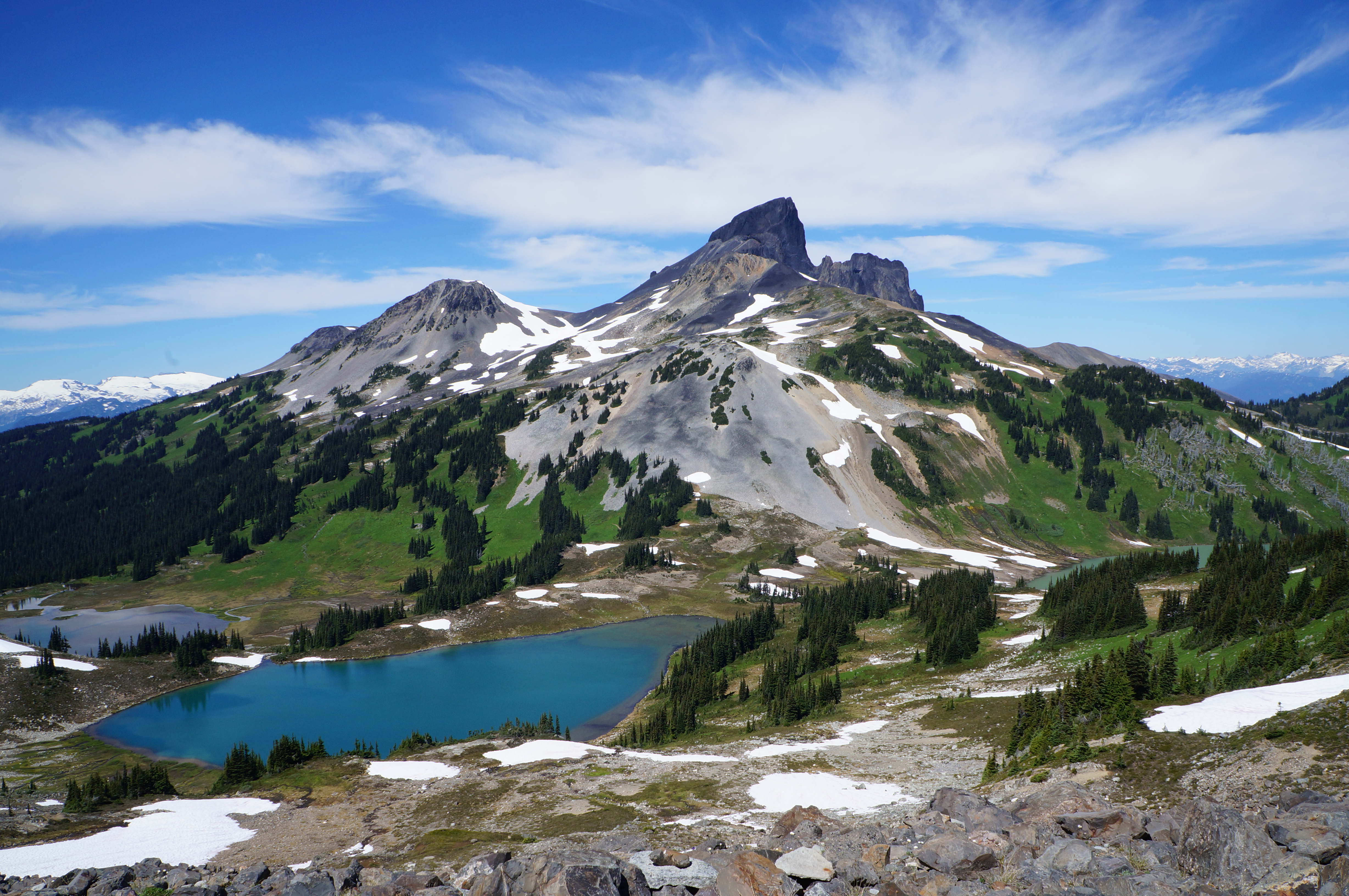
Eventually we arrived at Isaac Lake, the biggest lake on the circuit. I think it’s time to share a map of the circuit to give you an idea of the unique topography of this area. The circuit is very rectangular, with Isaac Lake having a notable corner in it. The west arm is ~7km long, while the main arm is ~31km long. We paddled Isaac Lake for 2 full days and it is definitely one of the more memorable lakes (both good and bad).

The water was really calm when we arrived and we could see a lot of the other groups still packing up along the shore from Campsites #11 and #12. I always live in fear of the afternoon headwind (which seems to be a thing everywhere we paddle), so our goal was to have early mornings and do as much paddling as possible before lunch. Since the water was so calm, we ended up paddling the entire 7km of the west arm in one go, over about an hour and a half. Overall, we paddled pretty fast on this trip, usually averaging around 4km an hour.

I should also mention that there are two kinds of campsites on the circuit: individual sites and group sites. If you have more than 7 people in your party, you have to make a group reservation. The benefit of the group reservation is that you have guaranteed campsites. Only 1 group leaves per day and only that group can stay at the group campsites. The downside is that you have to follow a fixed itinerary (I think it’s 8 days). There was no group on the circuit when we did it, so we were able to use group sites if desired. We made a stop at the group campsite (#14) at the end of the arm for a snack, and then continued our paddle down the main arm.

PSX_20250529_081836
PSX_20250529_082234

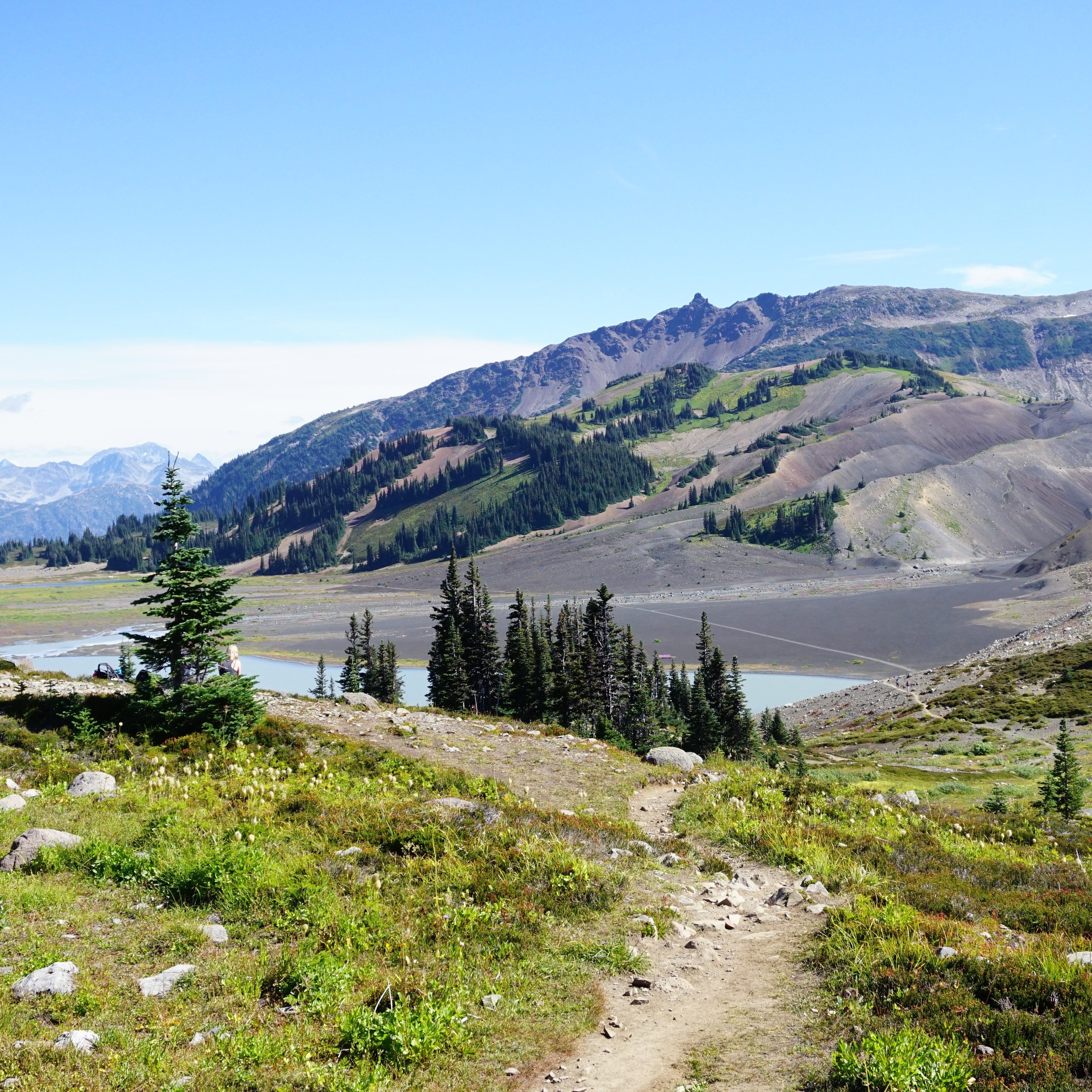
Isaac Lake is quite beautiful. It’s so long that you cannot see the entirety of the lake at any point and it is completely surrounded by mountains. The mountains were a bit coy when we paddled the lake because of the weather. It didn’t rain very much on Day 2, but it was overcast and the clouds hid a lot of the mountains. It did start to get a bit windy as we paddled down the main arm, so we stopped at Campsite #18 for lunch.

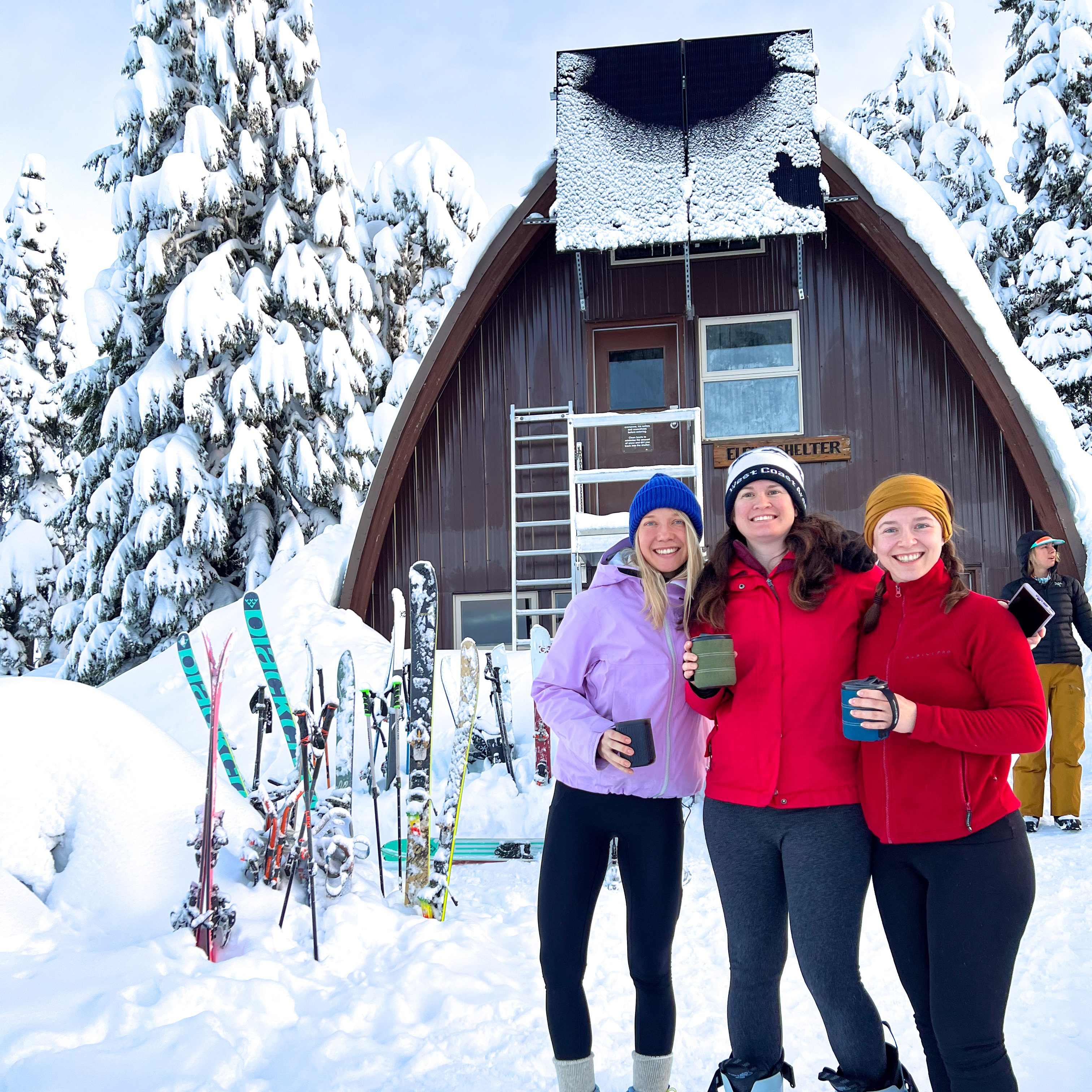
Campsite #18 is another campsite with a shelter. The wind really picked up while we were having lunch, so we strongly debated just having a short day and spending the night to take advantage of the shelter. But I knew there was another shelter 8km away at Campsite #20, so I was really on the fence. Our goal was to get to the end of Isaac Lake by the end of Day 3, and that would be a lot easier from Campsite #20. But the wind seemed to drop down after a while and we decided to make a go for it. We did have to fight with a headwind for a few kilometres, but the wind dropped off entirely before we got to Campsite #20 and it was almost flat water when we arrived. Thanks to the extra distance, it was one of our bigger days on the circuit and we travelled a total of 23km.

PSX_20250601_210929

We had to name the other groups we were sharing the circuit with to differentiate them from one another. There was a group of 5 kayakers that we creatively named 5 Guys (but apt because they were young burgers-and-beer kind of guys), and they were already settled in when we arrived at the campsite. They were very friendly and there was one tent pad left, so we took it and got to know their group a bit better around the campfire. We didn’t get any more rain for the rest of the night, so we ended up not needing the shelter. 5 Guys had a pretty raging campfire, so that kept us warm for the evening, and we had a good laugh as they regaled us with stories of accidentally capsizing in Kibbee Lake, 20 minutes into their trip!

On Day 3, we really got a bit of everything. We were up early and on the water by 8am again. When we paddle at home, the ocean is usually dead calm at 8am, and will often stay that way until at least 11am. I was surprised by some of the conditions on the Bowron circuit. I wouldn’t say it was windy in the mornings, but it was rarely flat water, even at 6am. The wind was never concerning in the mornings, but always a bit more breezy than I was anticipating.

PSX_20250529_082033
PSX_20250601_211113

We got in a few hours of easy paddling along the shoreline, but we had 21.5km to go to get to the end of Isaac Lake. Isaac Lake has a lot of little headlands along it, where the mountain meets the water and creates a small point. Around 11am, it started getting really windy. Usually it’s windier when you go around a headland, but once you make it to the other side, the wind dies down because you’re somewhat protected by the next headland. At 11am, we went around one headland where it felt like we were getting completely assaulted by the full strength of the wind across the lake. We could see really far down the lake and it felt like the wind was tunneling the whole way up it to hit us broadside. The way the wind was blowing, there was no shelter from the next headland and we had a very slow paddle through some nasty waves.

Eventually we reached the next headland and got a small break directly behind it. We were afraid to go around because we knew we’d be getting hit directly again on the other side, so we decided to wait it out for a little while. Like I said, the weather was all over the place on this trip and it was fairly normal for the rain and wind to storm up and down the lake, so conditions changed quickly and frequently. We figured if we waited even for 15 minutes, the wind could change, so we pulled our boats onto the very limited amount of available shoreline and settled in to wait.

PSX_20250601_211724
PSX_20250601_211806

Unfortunately, the wind only seemed to get worse and we could see whitecaps forming in the lake. After about a half hour, 5 Guys caught up with us and also opted to pull into the lakeside to wait. Shortly after they arrived, me and Seth decided to make an attempt at the headland, but the second we became exposed, we were getting hit by whitecaps, so we quickly did a 180 and returned to shelter. We ate our lunch while studying the waves for another 45 minutes or so. Eventually it looked like the wind was coming down a little bit, and we decided to go for it as a group. It was still pretty nasty, but definitely better than our first attempt and this time we made it through to the next section.

I think we were probably just at the windiest part of the lake and it did seem like the only way out was through. Once we made it through the next section, the wind definitely died down a lot and we all felt comfortable to keep going. Me and Seth took a short break at a real campsite, but then the rain showed up and we decided it was more comfortable to weather the rain in the boats.

PSX_20250601_211547
PSX_20250601_211444

One upside of the rain is that it does generally calm the wind and it can sometimes be windier on sunny days. The wind continued dropping and by the time we paddled through the rain, we seemed to have passed through one storm into another. The wind actually switched direction and we ended up getting a nice little tailwind for the rest of the day. The group of canoers that we nicknamed Canoe Bros, caught up with us later in the day and said that they had experienced the same thing. They described it as two storm fronts and they ended up catching a break for a while when they got caught in the calm between the two, and were able to ride it out for a few hours.

Fortunately that was the end of our wind woes for the day. 5 Guys branched off to do some fishing and Seth and I enjoyed the gentle tailwind propelling us the rest of the way to the campsite. Our goal for the day was Campsite #28, which is the last campsite on Isaac Lake. It’s a large site and I think it’s a popular spot for people to stop. It’s combined with a group site, but since there were no groups, we put it to good use between us, 5 Guys, and the Canoe Bros. It has a large shared shelter with a set of picnic tables and a woodstove, although the woodstove isn’t super useful because it’s an open-air shelter.

PSX_20250602_202718
PSX_20250602_202439

But the weather really cleared up in the afternoon and we actually got a couple of hours of sun! So we all lay out on the banks of the lake to soak in as much warmth as possible. The reason this site is so popular though, is because of it’s proximity to the most notorious water feature on the circuit, the Chute. It’s an optional paddling feature for those brave enough to try it, so people like to stop at the campsite for the night to assess the objective and hope to see someone else attempt it first!

It’s basically a line of standing waves, with an eddy on either side. What makes it tricky is that there’s a sharp turn at the end of the chute and if you exit to early, you can get caught in the eddy and then the waves will hit you broadside and quickly capsize your boat. No one attempted the chute in the evening, but we all spent hours discussing and sizing it up. Trying to figure out who was going to run it and whether we could wait around long enough to watch them attempt it first!

PSX_20250603_193526
PSX_20250602_202657

Seth was all for running the chute (mostly because he didn’t want to portage any extra distance). We assumed 5 Guys would all be down for the challenge, but they were having serious doubts after their capsize in Kibbee Lake. We caught an absolutely gorgeous sunset over the lake while debating it and Seth and I decided that since we had wetsuits, we would give it a try in the morning, but were really hoping to see someone else attempt it first.

Tune in next week to find out if we were successful in running the notorious Chute!

20250520_204237

Garibaldi Provincial Park Guide

If you live in BC, chances are you’ve heard of Garibaldi Provincial Park. I’m not sure if it’s quite as popular as some of BC’s National Parks, but it’s certainly developed a pretty wide-reaching reputation. Garibaldi Park is a large backcountry access park near Vancouver that captures a lot of the wilderness area east of Squamish and Whistler. You can’t drive to any of the park attractions, but it has not slowed down the number of visitors to the park. 

A photo of Black Tusk as seen from Panorama Ridge in Garibaldi Park on a blue sky day in the summer, with the alpine meadows and mountains in the background and lake in the foreground in BC.

Getting There

It’s impressive that Garibaldi Park gets as many visitors as it does when the access to the park is solely self-powered. The park is located between Squamish and Whistler, with several key park entrances at Diamond Head, Rubble Creek, Cheakamus, Whistler, and Wedgemount. Diamond Head is closest to Squamish, while the rest of the park entrances are closer to Whistler, so it can be a bit of a drive from Vancouver. I always give myself 1.5-2 hours of driving to get to the trailhead. Parking is generally secure, but there’s always the risk of break-ins, so don’t leave anything in your car.

Driving is by far the easiest way to get to the park, as public transit is not available. There is a park shuttle (Parkbus) that runs from Vancouver to Rubble Creek (the trailhead to Garibaldi Lake and Panorama Ridge) during late June to early October. The bus only runs on Fridays and weekends, and will book up early for Saturdays. Otherwise, there’s not many options and you’re best off trying to carpool with others via a facebook hiking group if you don’t have a car. 

A hiking trail extends through the alpine of Garibaldi Provincial Park towards Helm Lake, with the forest and mountains in the background on a sunny day in British Columbia, Canada

Activities

The most popular activity in the park is day hiking. Visitors park at a trailhead and spend the day hiking to various viewpoints in the park. The trails are all well maintained and make for a very scenic day in the backcountry. However, most of the trails cover considerable distance and elevation gain in a remote environment, so visitors should be prepared with the 10 essentials and leave a trip plan with someone they trust. For more information on trip preparedness and trip planning, see my Safety post.

Backpacking is also popular as there are 10 beautiful campsites spread throughout the park that can be visited as single night trips or along thru hikes. Biking isn’t permitted everywhere, but you can bike from Diamond Head and Cheakamus Lake, which is a popular activity for cyclists. Finally, lots of winter visitors use the park for snowshoeing or ski touring, either as a day trip, or for an overnight expedition. There is one hut available for camping at Elfin Lakes, which is popular in winter. Avalanche Safety Training is highly recommended if you are recreating in the park during the winter. See my Avalanche Safety post.

A group of 3 skiers traverse the ridge on the way to the Elfin Shelter at Elfin Lakes in Garibaldi Provincial Park, BC. It's a beautiful sunny day with lots of snow and the forest and Diamond Head Mountain in the background.

Permits and Day Passes

In the 10+ years I’ve lived in BC, Garibaldi has always had a reputation as a crowded park. In 2016, BC Parks brought in a reservation system for their backcountry campsites to reduce the impact to the natural environment from overflow camping. If you want to camp at any of the backcountry campsites, you will need an overnight permit. These are available on camping.bcparks.ca for $10 per person ($5 for youth), per night, and release 4 months in advance of your desired date. So if you want to camp on Aug. 15, make sure to book your pass on Apr.15. 

During the pandemic, BC Parks further regulated park use by employing a free day pass system from mid June to mid October to manage parking at the trailhead and impacts to the park from overuse. While these passes are free, they have generated a lot of criticism and frustration from visitors struggling to obtain a pass. The day passes release 2 days before your desired date at 7am, and from what I understand, they can be challenging to obtain due to popularity. My recommendation is to be ready at 7am and keep refreshing for up to 15 minutes. If you make a reservation on Parkbus, it includes a day pass.

The sun shines down during golden hour on Wedgemount Lake with the hut and the mountains in the background in Garibaldi Provincial Park, BC.

When to Visit

The park is popular year round, but it is important to understand that travel through the park has much higher risks in Winter and Spring. The most popular time to visit the park is in the summer (from July to September), but be aware that summer in the mountains is much later than summer in the city. You can usually hike to Garibaldi Lake starting in late June, but the snow in the alpine and along the trails to Panorama Ridge and Black Tusk may have snow on them into late July. Early Fall is also a good time to visit the park, but be aware that temperatures will drop quickly in the mountains and that limited daylight hours can make certain trails more challenging. 

Winter can also be a great time to visit the park, but avalanche safety training is highly recommended no matter where you’re going. Snowshoers and ski tourers will travel to Elfin Lakes and the privately managed Kees and Claire Hut at Russet Lake in the winter. Both of these routes pass through challenging avalanche terrain and I strongly advise completing an AST1 course before attempting these routes. The Red Heather Hut is also a popular location for skiers who want to do a few laps on Round Mountain before heading home. This carries less risk than the other trails because the route is only in simple avalanche terrain, but you should still exercise caution and be prepared. 

A female hiker looks tiny in comparison to the large Wedgemount Glacier in the background in Garibaldi Provincial park, BC.

Trails

There are so many trails to explore in Garibaldi Park. I’ve hiked all of them, with the exception of the winter glacier routes. Here’s some more information on trail options and links to dedicated resources for each trail. Please note that trail distances and elevation gain are approximate.

Garibaldi Lake (18km, 800m gain) – A great option for summer day hiking, or winter snowshoeing (with AST1). Probably considered the most popular hike in the park, with the trailhead at Rubble Creek.

Panorama Ridge (29km, 1500m gain) – Completed by some visitors as a long day hike (12 hours), but recommended as part of a backpacking trip (day hike from the campsite at Garibaldi Lake or Taylor Meadows). This is a very popular trail, with the trailhead at Rubble Creek. Only recommended in the summer.

Black Tusk (25km, 1400m gain) – Completed by some visitors as a long day hike, but recommended as part of a backpacking trip (day hike from the campsite at Taylor Meadows). This is a very popular trail, with the trailhead at Rubble Creek. Only recommended in the summer.

Mount Price (25km, 1400m gain) – Completed by some visitors as a long day hike, but recommended as part of a backpacking trip (day hike from the campsite at Garibaldi Lake). This trail is not very popular and requires some wayfinding, with the trailhead at Rubble Creek. Only recommended in the summer.

Helm Creek (16km, 650m gain) – Most often used as an alternative route when backpacking to Panorama Ridge or as a thru hike from Garibaldi Lake. The trailhead is at Cheakamus Lake and this route is less popular than the trails from Rubble Creek. Only recommended in the summer.

Garibaldi Thru Hike (~30km, 1500m gain) – Only completed as a backpacking objective in the summer. People will hike from Rubble Creek to Cheakamus Lake, camping at Garibaldi Lake, Taylor Meadows, or Helm Creek along the way.

Cheakamus Lake (9km, 50m gain) – A great option for beginner hikers, backpackers, and mountain bikers. It can be completed in a single day or as an overnight trip, camping at Cheakamus Lake Campsite. The trail is popular in the summer, with the trailhead at Cheakamus Lake. Can also be completed in the winter, but the access road is not plowed, making it a much longer hike.

Singing Creek (16km, 50m gain) –  A great option for beginner hikers, backpackers, and mountain bikers. It can be completed in a single day or as an overnight trip, camping at Singing Creek Campsite. The trail is popular in the summer, with the trailhead at Cheakamus Lake.

Elfin Lakes (22km, 600m gain) – A great option in the summer for day hiking and mountain biking, and in the winter for snowshoeing or ski touring (with AST1). Complete as a day hike or stay overnight at the campground or hut. A very popular trail, with the trailhead at Diamond Head (chains required for your tires in winter). 

The Saddle/The Gargoyles (27km, 900m gain) – An extended trail option from Elfin Lakes, can be completed from the parking lot in a single day, or shortened as a day hike from Elfin Lakes. The trailhead is located at Diamond Head. Only recommended in the summer.

Opal Cone (13km, 350m) – This trail can be completed as a day hike from the campsite at Elfin Lakes, or as a stop along the way when backpacking to Rampart Ponds. The trailhead is located at Diamond Head. Only recommended in the summer.

Rampart Ponds (18km, 500m gain) – This trail can be completed as a day hike from Elfin Lakes, or as a backpacking objective if you plan to stay at the campsite. The trailhead is located at Diamond Head. Only recommended in the summer.

Mamquam Lake (22km, 600m gain) – This Trail can be completed as a day hike from the campsite at Elfin Lakes, or as a shorter route from the campsite at Rampart Ponds. The trailhead is located at Diamond Head. Only recommended in the summer.

Russet Lake via Musical Bumps Trail (24km, 1300m gain) – Completed by some visitors as a long day hike (12 hours), but recommended as part of a backpacking trip, staying at the Russet Lake Campground overnight. This route requires paying for a sightseeing pass on the Whistler Gondola and hiking along the High Note or Half Note trails and the Musical Bumps trail. The trailhead is located at Whistler. It can also be visited in winter, but AST1 is required and a backcountry pass from Whistler Resort. 

Russet Lake via Singing Pass Trail (27km, 1200m gain) – Completed by some visitors as a long day hike, but recommended as part of a backpacking trip, staying at the Russet lake Campground overnight. The trailhead is located at Whistler and this route avoids having to pay for a pass for the gondola. Only recommended in the summer.

Wedgemount Lake (14km, 1200m gain) – This trail can be completed as a day hike or an overnight backpacking trip to the Wedgemount Lake Campsite. Overnight is recommended due to the substantial elevation gain. The trailhead is located at Wedgemount Creek. Only recommended in the summer.

Garibaldi Neve – This is a winter route for experienced alpinists only as it involves glacier travel. It is generally completed over 2-3 days and avalanche training and snow camping experience are required. I don’t have any experience with this route, please look elsewhere and do sufficient research and training before attempting.

Spearhead Traverse – This is a winter route for experienced alpinists only as it involves glacier travel. It is generally completed over 3-4 days and avalanche training and snow camping experience are required. I don’t have any experience with this route, please look elsewhere and do sufficient research and training before attempting.

A group of campers sit on the ground surrounded by camp food, pots, and stoves, preparing their dinner on the beach with the trees and lake in the background at Cheakamus Lake Singing Creek Campsite in Garibaldi Provincial Park in British Columbia, Canada.

Campgrounds

All campgrounds in Garibaldi Park require permits from camping.bcparks.ca. These release 4 months in advance of your desired date. They are popular, so it is recommended to book exactly 4 months before you want to visit. Backcountry permits are $10 per person ($5 for youth), per night. 

Elfin Lakes Campground – Reservable year round. There are 35 tent pads, several outhouses, picnic tables, a bear cache, and a cooking shelter. 

Elfin Lakes Shelter – Reservable year round. There are 33 bunks and an outhouse. You must bring your own sleeping pad and sleeping bag. 

Red Heather Campground – Reservable in winter only (Dec-Apr) for snow camping. There are no tent pads, but there is an outhouse and a cooking shelter. You are not permitted to sleep in the cooking shelter.

Rampart Ponds Campground – Reservable year round. There are 12 tent pads, an outhouse, and a bear cache. Sometimes this site floods in the summer and is closed.

Garibaldi Lake Campground – Reservable year round. There are 50 tent pads, several outhouses, picnic tables, bear caches, and four cooking shelters.

Taylor Meadows Campground – Reservable year round, except in September and October (I’m guessing because of bears). There are 40 tent pads, several outhouses, picnic tables, a bear cache, and two cooking shelters.

Helm Creek Campground – Reservable year round. There are 30 tent pads, an outhouse, and a bear cache. 

Cheakamus Lake Campground – Reservable year round. There are 10 tent pads, an outhouse, and a bear cache.

Singing Creek Campground – Reservable year round. There are 6 tent pads, an outhouse, and a bear cache.

Russet Lake Campground – Reservable year round. There are 7 tent pads, an outhouse, and a bear cache.

Kees and Claire Hut – While located in the park, this hut is managed by the Spearhead Huts Society (not BC Parks). Bunks can be booked year round for $60 per night and are most popular for touring in the winter.

Wedgemount Lake Campground – Reserable year round. There are 20 tent pads, a seasonal pit toilet, and an emergency hut that can be used as a bear cache. 

Three female skiers pose in front of the Elfin Lakes shelter on a sunny day in winter with the hut in the background and snowy trees in Garibaldi Park, BC.

Widgeon Creek Paddling Trip

I’ve written about Widgeon Creek in the past when I visited as a day trip with my kayak, but this year I made an overnight trip to stay at the campsite! I only paddled the creek for the first time last year, but it’s quickly becoming one of my favourite paddling locations in the lower mainland. It makes for a great day trip or overnight objective. The campsite is large and hiking to the waterfall is a great side mission!

But let’s start from the top. I did this trip with my Girl Guide unit, and I specifically call it a paddling trip because they all travelled there in canoes! I intended to canoe too, but one girl got sick at the last minute, so I ended up taking my kayak since we had an odd number of people. This was my first time doing a trip like this with the girls and we’re lucky to have a very experienced canoeist Guider in the unit to lead the trip.

PSX_20250512_084335
PSX_20250512_083301

While I love my kayak, canoeing does seem a bit more quintessentially Canadian and I was happy to finally learn some canoeing skills. We did two training sessions on Deer Lake before this trip so that the girls could get used to the paddling strokes. Widgeon Creek isn’t a hard objective, but it does require crossing the fast moving Pitt River, and it was important for everyone to feel comfortable and confident paddling. I found canoeing to be a bit harder that kayaking because of the coordination required with your partner. There are more paddling strokes (at least, that’s how it felt) and I initially found in confusing which stroke to use to correctly change direction. But eventually it clicked and I had fun learning a new skill!

If you want to visit Widgeon Creek yourself, you can park at Pitt Lake. The first part of the trip is crossing the Pitt River, after which it’s a 4.5km paddle up the creek to Widgeon Campsite. You can bring your own boat, or once they open for the season, rent right at Pitt Lake. Fortunately, we were able to borrow enough boats for our group, so we were could go a little before rentals opened for the season. We only had a small group of girl guides, but they were enthusiastic and very good spirited!

PSX_20250512_084012
PSX_20250512_083904

We started our paddle early in the morning to avoid the wind and arrived at the campsite in time to set up our tents and eat lunch. The paddle takes ~90 minutes and we made one stop at a pullout along the way for a snack. It rained on us pretty consistently, but no one complained and I noticed that the campsite was considerably less busy than on a sunny day. We were the first to arrive and we were only joined by one other group later in the day.

The campsite is fairly large and has lots of bear caches and picnic tables. I imagine it gets busy in the summer, but there are quite a few tent pads and space to spread out. We started by setting up a tarped area to hang out in so that we wouldn’t continue to get wet from the rain. Fortunately, the rain died off after lunch and we opted to hike 6km round trip to Widgeon Falls. It’s a nice trail through the forest that took us around 2 hours, with a snack break to enjoy the view at the falls. Be careful when it’s wet though, the rocks near the waterfall can get very slippery, so we exercised a lot of caution looking for a place to sit have our snack.

PSX_20250512_083539
PSX_20250512_083658

There’s no campfires allowed any time of year at Widgeon Creek, so we returned to the campsite to make dinner and play some games instead. In the morning, we got lucky with nicer weather and we were able to pack down the tents in dry weather. We had a nice paddle back to Pitt Lake, but the wind always comes up in the afternoon and it did pick up just before we crossed the Pitt River at 11:30am. The Pitt River can have a fast moving current, especially in the Spring, around freshet, so we planned accordingly by paddling along the edge of the river, upstream of where we wanted to cross, and then crossing to the boat launch. The current did knock us back a little bit while crossing, but everyone made it without too much issue.

Timing is an important consideration for visiting Widgeon. The creek and the Pitt River are tidally influenced, so they can be a bit high in the spring, but get very low in late summer. I’ve heard that sometimes the creek gets so low you have to walk your boat in places. But it is a very manageable location to visit if you plan around the tides. I’ve been 3 times now and always had a great time! Most of the paddling is located in Widgeon Marsh Regional Park, but the campsite itself is in Pinecone Burke Provincial Park. There’s no permits required to camp there and it is free to visit. It’s a great paddling trip close to Vancouver. We had a great time visiting as an overnight trip!

PSX_20250512_083354
PSX_20250512_083758