ECT Series: White Horse Path

White Horse Path is one of the newer sections of trail on the East Coast Trail, and locally it has developed a bit of a reputation. The trail is located on the northwest section of the ECT, running from Bauline up to Cape St. Francis. It’s 16km long and is listed as “strenuous” due to the repeated hills running across the length of the trail. The net elevation is 0m, of course, but I tracked almost 700m of up and down on my GPS.

I’ve been wanting to hike White Horse Path for a long time, but I’ve always been a little bit intimidated by it. The East Coast Trail seems like it would be easy compared to some of the mountain hikes I’ve done in BC, but I’ve been humbled on the ECT more than once. The Spout was by far the hardest section of the trail I’ve done. I hiked it with Emily and we both hobbled out at the end of the trail. The repeated up and down of coastline trails is really hard on your knees. 

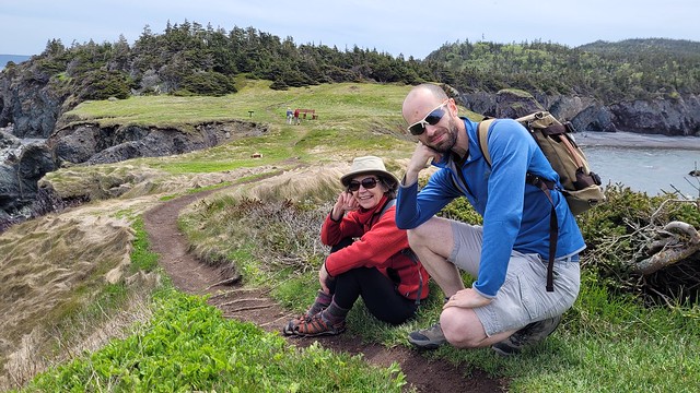
So I was a little anxious about hiking White Horse Path, but I was determined to finally do it on my most recent trip home in 2025. We had really nice weather, so me and Emily decided to tackle the trail the day after we hiked Bear Cove Point. This was a good strategy in that we were training for a bigger hike later in the summer and it was good practice to hike two days in a row. But also a bad strategy because we started a bit late and it was really hot. 

PSX_20250708_105017
PSX_20250708_105117

Like I said, White Horse Path has a lot of big climbs and descents along the trail and runs through pretty remote terrain. We didn’t want to end with a big descent, so we decided to start in Bauline and hike to Cape St. Francis. We dropped Emily’s car at the lighthouse and our Dad dropped us off at the trailhead in Bauline. The trail is really beautiful and it starts with a big climb out of Bauline. Emily was definitely struggling right off the bat with the incline, but I’d been having a pretty good hiking season and was feeling strong. 

This really is a stunning section of trail and I think it’s mostly the length that contributes to its difficulty. There’s a mix of forest sections and exposed coastal bluffs along the trail, but I would say it’s one of the more scenic parts of the East Coast Trail, with lots of views along the way. The morning was challenging for us because it was so hot and there was a lot of climbing. Normally I like being in the trees for shade when hiking on a hot day, but it was nicer being on the bluffs on this trail because of the breeze. 

There is a trail connection to Marine Drive Park around 3km into the trail where we saw a family out for the day, but other than that, we didn’t see anyone until the end of the trail. We stopped for lunch around 6km, which left a lot of trail for the afternoon. There’s not a lot of options for water along the trail and the streams were running pretty low, so I’d advise packing all the water you need for the day. 

PSX_20250708_105312
PSX_20250710_224144

We hit the campsite at the 9km mark. There’s two brand new tent pads and a bit of flat space for camping, but not a lot of room. There is a small stream that is flowing, but you definitely want a filter. At this point in the trip, Emily was feeling tired, but still powering through. I really enjoyed everything that came after the campsite and I think this is the more scenic half of the hike. There’s a small uphill section after that campground, and after that you hike across exposed flat rock for a while. It was really nice and breezy, so we decided to take our last snack break to enjoy the view. 

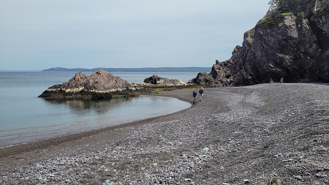
The last part of the trail was worrying to Emily because there’s a lot of downhill and she finds that hard on the knees. After leaving the bluff, we had the biggest downhill section of the trail as we climbed down towards Cripple Cove. I don’t think the trail follows the most economic route to Cape St. Francis. It follows the coastline rather than the most direct route, which makes sense, but is a little frustrating when you’re tired. Once you get down towards Cripple Cove, you can continue to a viewpoint up on the rock, which looked pretty cool, but we skipped it. It’s not that far a hike from Cape St. Francis, so I might come back one day to check it out. 

PSX_20250708_105225
20250629_142821

Instead, we started our last climb back up towards the Cape. All day, it felt like we were moving pretty slowly. We didn’t start the trail until almost 11, which was really too late for a trail like this. So I constantly felt like we were behind the pace we should be at, but we ended up finishing the trail in just over 8 hours, which was our goal, so we were moving at a pretty reasonable pace all day. We did slow down over the last couple of kilometres though. There’s one more downhill as you wind your way back to the Cape and this was the section of trail that really did Emily in. She’d been wearing one knee brace most of the day, but her second knee started tweaking, so she borrowed my knee brace as well, which I wasn’t using. She really struggled for the last kilometre and similar to the Spout, she had to hobble her way out the last section of trail.

The trail is not easy on you at the end. We could see the lighthouse as we winded down through the last section and it felt like we were pretty much done, but you have to climb around Back Cove at the end and this part of the trail was surprisingly technical. You scramble across some narrow rock and then there is one section of trail with chains to hold onto, followed by a lot of stairs. I’m glad we were hiking north because that meant we did the chain section uphill – it looked like it would be a lot scarier going down. 

Technically, the trail winds back to the lighthouse after Back Cove, but we’d been to the lighthouse before and we were able to find a shortcut through the brush back to the car. We came out of the woods on the road and even though we were only 50m from the car, Emily made me go get it and come back to pick her up! When I got back, she was sat down on the grass nursing her knees and the last of her snacks! So I guess the trail association is right to call this hike ‘strenuous’. 

PSX_20250710_224225
PSX_20250710_224246

It’s not all pain though. Personally, I had a great time on the trail. I did think it was a challenging trail, particularly because of the heat. I was surprised we were able to finish in 8 hours at our pace, but I think I definitely would have done this trail at least an hour faster on my own. It’s nice to take your time and enjoy the views. I think me and Emily both had different perspectives on the trail. My friend asked me how it was afterwards and I told him I had a great time (which I did) and that the trail wasn’t too hard. But then Emily told him not to believe a word I said!

So if you’re a frequent hiker, I don’t think this trail is as intimidating as it’s made out to be, but it’s definitely not to be underestimated. Emily is thrilled to have checked it off her bucket list, but has vowed she’ll never do it again. Personally, I would return for round 2. I think it could be fun to camp on the trail, but I’m not keen on doing it again with a full backpack, so maybe it’s better as a day hike. Either way, I’m glad that I can finally check this section off my list. Only one section left for me to complete and I’m be damned if I don’t get to it next summer!!

Rockcut Trail: Codjacks Cove

In addition to my series on the East Coast Trail, I’ve also been writing about the Rockcut Trail, both located in Newfoundland. For those new to my blog, I grew up in Newfoundland and spent the first 23 years of my life there. I’ve explored most of the 300km long East Coast Trail by section hiking (I just have 3 left) from St. John’s, where my parents live. My Nan lives in Twillingate, which is a beautiful island on the central north part of the (big) island. It’s accessible by causeway and is popular among tourists for whale watching and iceberg hunting. They recently re-branded all the trails on Twillingate Island as the Rockcut Trail and have been improving them, so I’ve been trying to hike them all. See my other posts on Little Harbour and Top of Twillingate

20240901_125754

In Summer 2024, I visited with my sister, Emily, and my friend Brandon, who came all the way from BC to explore Newfoundland! Our biggest priority was to go fishing (which we were able to do twice) and visit with Nan, but we managed to find a bit of time to hike Codjacks Cove. This trail is located on the northeast side of the South Island and leaves out of Durrell. Drive down Horwood Lane to find a small parking lot. The road continues on from there, so if you take the left branch (the right branch goes to the dump), you can drive a bit further, but it was a nice day, so we just walked it. 

20240901_132605
20240901_124938

Once you hit the coast, there’s a wooden staircase that heads down to Codjacks Cove and you can hang out on the beach. There is a single tent pad at the back of the beach that is newly installed if you feel like camping out! The trail is an out-and-back, so we skipped the beach on the way in and continued along the trail. The trail goes through the woods and along the rocky coastline of Gunning Head, with beautiful ocean views wherever you look! The trail supposedly continues all the way on the Little Harbour, as they’ve been working to connect all the trails into one longer thru-hike, but we just hiked for ~3km before turning around and heading back, since we only had one car.

20240901_132956
20240901_123325(0)

We had a beautiful day for it, though it was windy of course! We stopped into the beach on the way back and I went for a little skinny dip by myself because Emily and Brandon were too chicken to participate! Well, Brandon was too chicken, Emily just didn’t want to. Like every trail on the island, it’s very beautiful. They’re all pretty similar, so you really can’t choose wrong. You can read more about the other sections of the Rockcut Trail on their website. I only have one section of trail left to explore in Purcell’s Harbour, but it’s been many years since I’ve done some of the other sections, so I plan to re-do them before writing about them. Twillingate is really special to my entire family and I feel lucky to call a little slice of this island home. 

Chance Cove Coastal Trail

I recently made my annual summer trip home to Newfoundland for 10 days in early June and had the best time exploring some new trails! I wasn’t thrilled about going home in June because it’s not the nicest weather in Newfoundland at that time, but I ended up having to eat my words because I had really good luck while I was home! I got such fine weather I ended up doing 55km worth of hikes in just 7 days – the first of which was Chance Cove Coastal Trail.

IMG-20220613-WA0016

Chance Cove is located about an hour and half outside of St. John’s on the far end of the Avalon peninsula on the isthmus. Chance Cove has definitely been trending on Newfoundland social media throughout the pandemic and I was starting to feel like everyone I knew on the island had been there over the past year. It looks incredibly scenic in photos, so I admit to being drawn to this hike by Instagram and I was determined to check it out for myself.

We got nice weather on our first weekend home and I convinced both mine and Seth’s families to do the hike with us. It’s only ~4km round trip and is fairly easy terrain, but it’s so scenic it ended up taking us 2.5 hours to do the whole thing!

20220612_124701

What makes this hike especially nice is that it’s a double loop hike (kind of like a figure 8), so you get different topography along the entire hike. We started by climbing up into the woods until we reached Chance Cove Beach, which extends across the cove to the main road, then we switched back to the coastal route up towards Green Head. It was overcast and extremely windy when we started, with Green Head being the most blustery part of the trail. We hiked up to the head, but didn’t stay long because it was so cold, though it was cool to watch the wind swirl erratic patterns through the water.

20220612_124910

From Green Head, you continue along the headland past Chance Cove Island to Island Cove Beach, where fortunately, the headland shelters you from the worst of the wind. There’s a newly constructed set of stairs going down to Island Cove Beach, so we took a long break on the beach to eat our snacks and enjoy the warmer (less windy) weather. As we continued on, the clouds started breaking up and pretty soon the sun was shining down on us!

20220612_131238

The next attraction is Patrick’s Cove (also known as Big Cove), but first you can hike up to a series of viewpoints between the two coves. With the sun shining, it completely transforms the landscape and the water turned the most vibrant shade of blue! You could almost be tricked into thinking you were somewhere tropical, if not for the wind.

20220612_133325

You can also hike down to Big Cove, which has a huge sea stack that is centered in most of the photos I’ve seen on social media. Unfortunately, there are no stairs going to Big Cove, just a large rope guiding you down the bank. I really wanted to see it, so I climbed down, but it’s still really steep and not for the faint of heart. The rope is positioned pretty awkwardly and some of my family members had some trouble, so I wouldn’t go down there if you’re not confident in your abilities. Definitely use caution.

PSX_20220612_182515
20220612_134748

If you do decide to climb down to beach, it is very lovely and would make a great place for a swim. Me and Emily toyed briefly with the idea of going for a dip, but we didn’t have swimsuits and it was a bit too breezy to air dry. We opted instead to wade out up to our knees. It wasn’t quite as cold as I was expecting at first, but it quickly starts to numb your feet and I had to stumble back to the beach to defrost!

PSX_20220615_101406

From there we hiked back up the bank to get what I’d call the “money shot” of the hike. A view from above of the curved beach and sea stack. It was no longer sunny when we got there, but no less scenic! After that it’s a pretty easy walk back to the parking lot. There’s a small climb and then you head back down towards Chance Cove. You can cross the beach if you prefer, but given the wind, we decided to just hike back along the water instead.

20220612_141428

We concluded our day with a visit to Baccalieu Trail Brewing Co. in Bay Roberts to sample some of their beer and “legendary” cod chowder. The sun returned while we sipped our beers on the patio and we congratulated ourselves on a very successful day. Chance Cove Coastal Trail definitely lives up to the hype and I would recommend it to pretty much anyone. Use caution if climbing down to the beach, but otherwise it’s a fairly easy hike that’s great for beginners! We had a great time.

20220612_155122