Berg Lake Backpacking Trip: Snowbird Pass

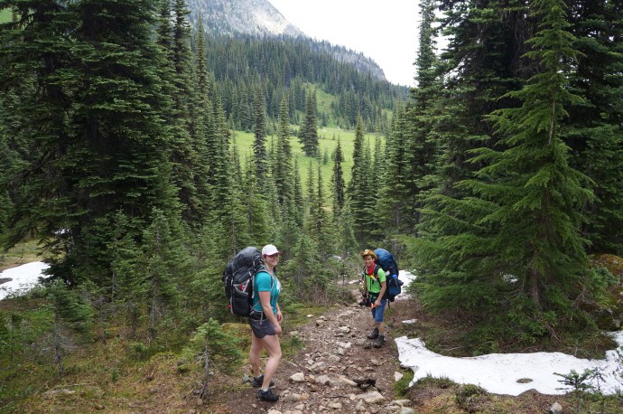
Now that I’ve completed this trek, I feel like everything on our trip to Berg Lake was culminating up to our day hike to Snowbird Pass. This is a well known side mission on the Berg Lake Trail, but it’s a big one. You definitely need a full day if you’re going to attempt it, so plan accordingly. If you want to go all the way to the top of Snowbird Pass, it’s a 20km hike with ~800m of elevation gain.

The great thing about this hike is that the entire thing is incredibly scenic, so if a 20km day hike is too much for you, it’s really easy to shorten or customize this trip to your liking. I’m glad that I went the whole way to Snowbird Pass, but I also feel that I could have stopped hiking at any point on the trail and I would have been totally satisfied with what I’d accomplished (a peak bagger, I am not). But we wanted to give ourselves the best possible chance at getting to the pass, so we were up early and on the trail by 8:30am.

20250805_171257
20250805_091110

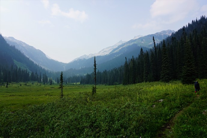
The weather was still treating us well and the trail starts with a leisurely walk along the Berg Lake flats. There’s a lot of broad-leaved willowherb growing along the river (also known as dwarf fireweed or river beauty) that I’ve really come to appreciate this year. We got a glimpse of Rearguard Campground, which is located 1km from Berg Lake. It has really nice views of Berg Glacier and Mount Robson, but it’s pretty exposed and doesn’t have a shelter, so I’d probably still pick Marmot Campground if I couldn’t get permits for Berg Lake.

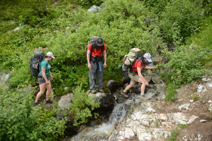
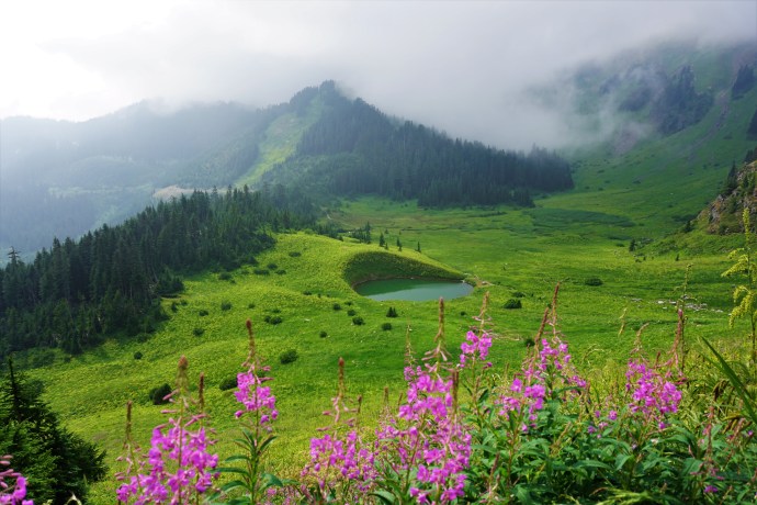
After Rearguard, there’s a trail junction and you can continue on to Robson Pass Campground, or head east towards Snowbird Pass. The trail is pretty exposed all day, so we were happy to have a cloudy day to do this hike – I imagine it could be quite hot and draining on a sunny day. As you hike through the alpine, you start to get a glimpse of Robson Glacier, which wraps around the side of Mount Robson. Like Berg Glacier, Robson Glacier is stunning. It’s absolutely massive, with lots of texture and an ice-blue colour. The closer you get, you also start to see a small lake that has formed at the base of the glacier. I’m not sure if this lake has a name, but it’s much more silty than Berg Lake and it has a lot of bergy bits (as a Newfoundlander, I can assure you this is the correct technical term) floating in the water.

20250805_090852
PSX_20250820_230156

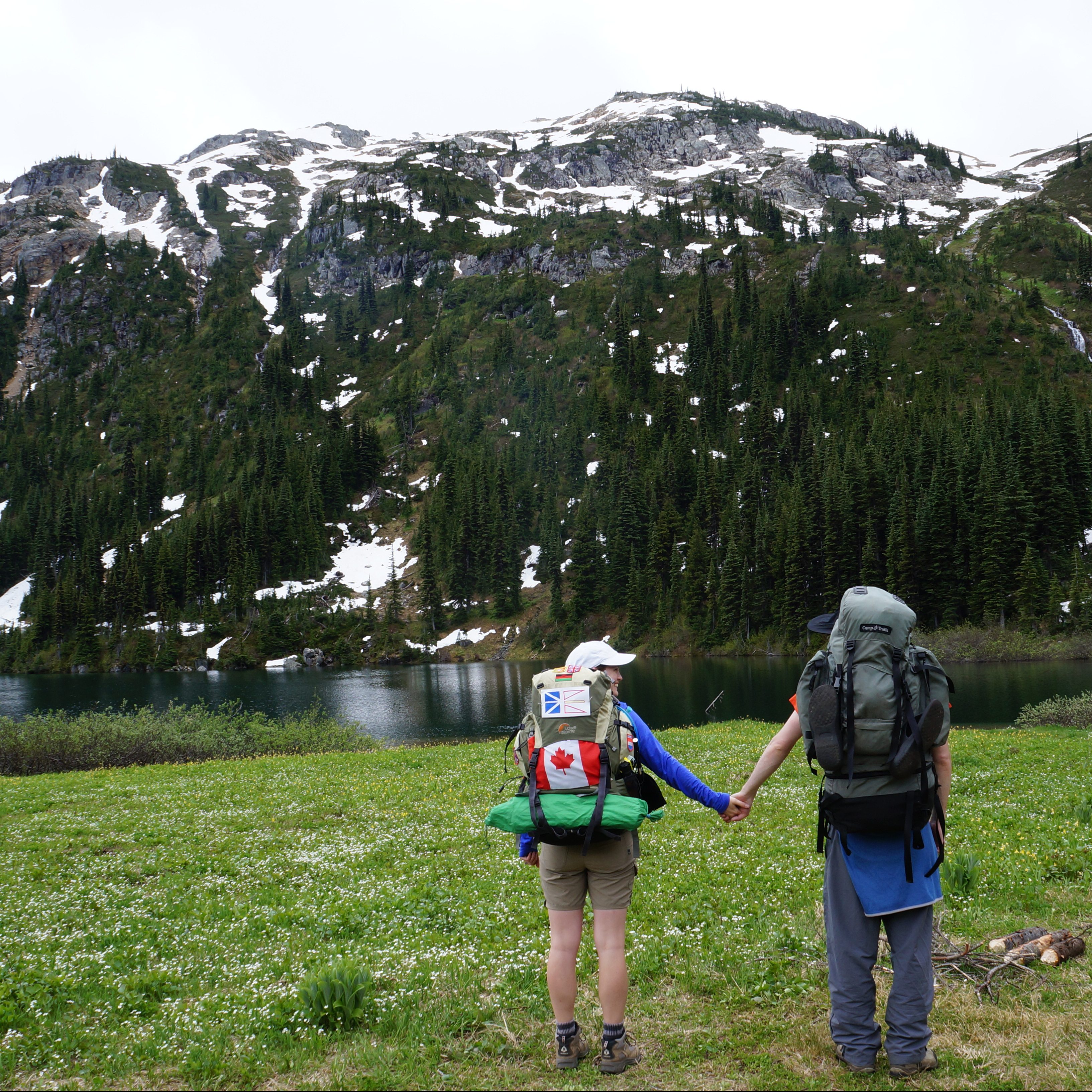
If you don’t have the time or ability to do the entire Snowbird Pass Trail, visiting the lake is a great objective. It’s ~3km from Berg Lake to the Robson Glacier lake and it’s completely flat. It would make a great side trail and provides a fantastic view of the glacier. It gets a lot more challenging after the lake, so if you only have a little bit of time, just go as far as the lake.

From the lake, the trail quickly ascends up the rockface towards the glacial moraine. In my opinion, this is the hardest section of the Snowbird Pass Trail. It’s very steep and the wayfinding can be tricky in some areas. It’s definitely preferable to do this on a dry day because there’s some scrambling over large rock and this could be challenging when slippery. There is one section with a chain (photo of Brandon below), however I thought this part looked scarier than it actually was. You don’t really need the chain to help you climb up and I thought it served as more of a guardrail than anything else. But certainly a nice-to-have, especially if you’re afraid of heights (this might not be the hike for you if you don’t like heights though).

PSX_20250820_230110
PSX_20250820_230432

The trail climbs 250m in 2km over rocky terrain until you reach a sort of rock landing (photo of me above), before starting to hike along the glacier moraine. It has a fantastic view of the glacier as it gives you a higher vantage point. We honestly couldn’t believe our eyes the entire time we were on this hike because the views are so out of this world and it’s one of the closest hikes I’ve ever done to a glacier (often you just hike to the base – it’s rare getting to hike alongside a glacier without the danger of actually being on it). We stopped at the rock landing for a snack break before continuing on; if you don’t mind doing the climb, this would be another great objective for a smaller day hike. It’s a better view than the lake, but it’s only half the distance of the full hike to Snowbird Pass.

We didn’t see anyone on the trail up to this point, but we got passed by a few other hikers when we stopped. Overall, we saw a lot more people on this trail than when we did the Hargreaves Lake Loop. But it’s a 20km trail, so it never felt crowded. We were some of the earliest hikers on the trail, so we encountered most of the other hikers on the way down.

IMG_2296
PSX_20250820_230314

After the first big climb, you get a break as the trail continues along flat terrain for 1.5km while you hike directly on top of the old glacial moraine! I thought this was incredibly cool. It’s not strenuous and I felt like I was on top of the world. I must have taken hundreds of photos of the glacier along this stretch because it completely blew my mind while hiking it. Another option for a shorter day hike could be to add this 1.5km stretch to your hike, since it’s pretty easy walking.

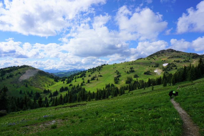
Eventually you reach the end of the moraine and the trail starts a second climb up to the alpine. I was prepared for another strenuous climb, but it wasn’t as bad as I was anticipating. It does start off pretty steep, but it levels out quickly and after 100m of elevation gain, the trail flattens into an alpine meadow. The trail is technically still uphill through the meadow, but it’s such a gentle climb you don’t really notice it.

20250805_105047

There’s an incredible view of the glacier when you hit the meadow. There’s beautiful babbling brooks cascading down through grassy fields, as well as an amazing view looking back down the valley towards Robson Pass. This view is located somewhere between the 7-7.5km mark, so it could be another shorter hiking option if you don’t mind the extra climb. The citizen science storyboard about contributing to tracking glacier recession is a good landmark for this view.

If you decide to go past this point, I recommend just committing to the entire hike to the top of Snowbird Pass. I love wildflowers, so I always get really excited about alpine meadows. This one felt extra special because I didn’t know it was going to be there! It’s so barren hiking along the glacier moraine and it’s barren again at the top of Snowbird Pass, so the lush meadow in between was an unexpected surprise. After a brief hike in the meadow, you round a corner where you can see Snowbird Pass off in the distance. It doesn’t look too bad, but it’s deceiving as there is still a fair bit of elevation gain left.

IMG_2369
20250805_114320

We enjoyed the hike through the meadows, encountering a lot of marmots who definitely weren’t intimidated by us. As you get closer to the pass, the hike to the top starts to look more and more daunting. It was around noon when we finally started hiking up the final steep scree trail and I was definitely feeling ready for a break. You do about 200m of elevation gain through the meadows, and then finish with a steep 150m push to the top.

At this point, there were 2 or 3 groups ahead of us, so I was surprised to find the pass empty when we finally summited. Turns out, they had all immediately continued on up the ridge. I’m not sure if this was everyone’s goal, or if groupthink took over and they all thought they had to push further. There looks to be a faint trail, but it’s very steep and it eventually disappears into a scramble. I didn’t have any interest in going further, so we happily dropped our packs to enjoy having the pass to ourselves.

20250805_114645

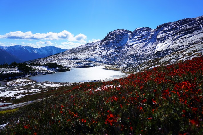
Snowbird Pass is really unlike anything I’ve ever hiked before. Berg Glacier and Robson Glacier are stunning, but it was from Snowbird Pass that I got to experience my first icefield! From the top of the pass you can see Reef Icefield, which is a flat expanse of ice that extends as far as the eye can see if every direction. In the distance I could see towering mountain peaks, giving the illusion that I was looking across a sea of ice. I would say that this ice is not as dynamic or interesting to look at as Berg or Robson Glaciers, it looks more like snow, but the scale of it is mind-blowing.

The other thing that’s interesting about Snowbird Pass is that it marks the boundary between BC and Alberta. Mount Robson Provincial Park is located in BC, but the icefield is in Alberta. We hung out for a long time admiring the icefield and eating our lunch. I’m not sure how far up the ridge people went – but some hikers re-appeared on the slope above us, so I don’t think they went too far. I don’t feel like I missed out on anything by not going up the ridge. You would get a higher view of the icefield, but I think you’d have to go pretty far up the ridge for it to be substantially better (but I didn’t go up there, so what do I know).

20250805_121852
PSX_20250820_233214

We spent the better part of an hour on the Pass before starting our descent back. There is a scree section at the very top of the pass, so that part wasn’t fun, but it’s not too bad after that and I really enjoyed our hike back through the meadow. There’s lots of freshwater sources in the meadow, so if you plan to hike that far, you don’t need to bring too much water if you’re willing to filter on the trail. We saw some more marmots in the meadow and I loved hiking back towards Robson Glacier because you can still see it looming above you as you approach.

There’s not too much to say about the return trip. It’s just as scenic as the hike in, but we did notice the clouds starting to darken as we hiked along the moraine. Shortly after we started the steep descent back towards the lake, we had an exciting surprise when a mountain goat wandered across our path. Brandon had been enthusiastically looking for mountain goats the entire trip and we were starting to get concerned that we wouldn’t see one! There’s a mountain goat on all Mount Robson’s promo materials, so we came to think of it as a mascot for the park.

20250805_135430
20250805_142222

We enjoyed watching the goat navigate the steep terrain, but the weather finally caught up with us and it started to rain. We were on the steepest and sketchiest part of the entire hike, so we quickly started to head down before the rocks could become too slick. It rained for ~15 minutes, but similar to the previous day, it was only a sprinkle before quickly moving on. We made it back to the lake just as the rain let up.

When we passed the lake on the way in, I vowed that I would swim in it on the way back. Brandon laughed at me because there are a lot of things he’d rather do than swim in a lake with bergy bits, but I love a good cold dip and I was convinced I would do it. After bundling up for the rain and with a pretty solid headwind blowing through, I was feeling chilled and much less confident as we circled around the edge of the water. We were about to continue back to camp when I finally gathered my resolve and led us off trail to a small sheltered beach.

Screenshot_20250908_222451_Gallery
20250805_153322

It was definitely one of my less enthusiastic times stripping down to my swimsuit, but I really wanted to be able to say I’d swam in all the lakes (I might not be a peak bagger, but I’m definitely a lake bagger). While I got into my swimsuit, Brandon dug out his toque and gloves, refusing to so much as touch the water. It was definitely one of the colder places I’ve swam (much colder than Berg Lake), and it was really more of a dip than a swim, but I did it! And you know what, I did feel a lot better for it. As I dried off and put my warm clothes back on, I did actually feel warmer.

We decided to take a detour on the way back to swing by the Robson Pass Campground, which is located 1km from Rearguard Camp, and 2km from Berg Lake. Similar to Rearguard, it doesn’t have a shelter, but it is close to the new ACC hut, which we were able to catch a glimpse of. The sun came out as we hiked back to Berg Lake and we enjoyed another beautiful evening by the lake. The rain didn’t return and we celebrated our big day with my homemade backcountry apple crumble dessert!

20250805_161830(2)
Screenshot_20250908_222348_Gallery

I had one last bit of excitement before bed. I met an older couple and ended up having a lengthy chat when I learned that they had lived in Newfoundland for 20 years before retiring back to BC. While we were talking, a moose wandered down the creek bed by my tent, followed by what looked like her yearling calf! They didn’t stay for long and quickly exited towards the flats, but we all felt so lucky to have glimpsed the pair!

The following day finally brought some of the marginal weather we’d been promised all week. After three clear evenings, we awoke to thick clouds obscuring the mountain. We had completed all our major hikes, so we weren’t bothered and we enjoyed a late start and leisurely breakfast on the shelter patio as the fog moved around. I transitioned into the more social part of the trip and befriended a few girls from Edmonton who paid me the nicest compliment, “I am not a bit surprised that you are a Newfoundlander, and I mean that in the best possible way!”

Screenshot_20250908_222524_Gallery
20250806_120601

Eventually we departed Berg Lake to hike back towards Whitehorn Campground for our final evening on the trail. The rain rolled in and out throughout the day and we had a particularly stormy section as we crossed the flats from Marmot Campground. It was windy and rainy, so we completely bundled up in our waterproofs, only to ditch them again 20 minutes later.

We continued to make friends and I had a great chat with a couple from Belgium when we rolled through Emperor Campground. After 12 years in BC, being from Newfoundland is a much smaller part of my personality than it used to be, but this couple were very enthusiastic history nerds and asked me a lot of questions about Newfoundland’s history. This devolved into a pretty detailed discussion of Newfoundland’s late entry to confederation, which I do love to talk about, but rarely have such a captive audience. If you don’t believe me, check out this lengthy blog post I once wrote about it.

20250806_114223
20250806_121034

We probably could have hiked the whole way out on the last day and skipped Whitehorn Campground, but I didn’t mind spending the extra night there. It allowed us to have a slower paced day and we arrived at camp just before the first true downpour of the trip. There’s a large communal shelter at Whitehorn, so after setting up our tent, we spent the rest of the day getting to know the other campers. Like I said, I really love hiking in the Rockies for the community aspect of the hiking. I rarely experience this same kind of vibe on the trails near Vancouver, except maybe on the Sunshine Coast Trail, so it’s nice to take the extra time to meet new people and swap stories.

But that pretty much marked the end of our trip. We decided not eat lunch on the trail in hopes of nabbing a burger. It took us just over 3 hours to hike the 11km back to the parking lot and we were thrilled to return to civilization! We were not rewarded with a burger as most of the restaurants in Valemount were closed until suppertime, but we drove the extra distance to Clearwater, where we were able to shower before finally tracking down a smashburger (me) and a rack of ribs (Brandon). In conclusion, the weather was not what we expected, but I honestly couldn’t have imagined a better trip and I hope to return again one day!

20250805_121630

Tenquille Lake Backpacking Trip

Tenquille Lake is a lesser known trail in southwestern BC, located near Pemberton, but it was the first trail I ever did on an overnight trip! Before my visit to Tenquille lake, I had never been on a backpacking trip before. I’d done lots of camping and hiking growing up, and I even went on a 5 day hiking trip to Machu Picchu in 2013, but it was my first time being wholly self-sufficient and having to carry all of my gear with me (in Peru we had horses to take the bulk of our gear). Well… I mean… I was mostly self-sufficient. I definitely couldn’t have done it without Brandon’s expertise, but I still carried most of the gear I needed for the trip.

3 years later I’ve completely fallen in love with backcountry camping and I have gotten a lot better at it, so don’t be afraid to take that first trip if it’s something you want to try. It’s important to be as prepared as possible, but you can also learn by doing. As long as you practice “leave no trace” camping and take your “10 essentials”, everything else can be learned with time!

The ideal scenario for your first time camping is to have a Brandon, by which I mean, an enthusiastic friend who has more gear and knowledge than you and is willing to help you out while you learn and accumulate your own gear. Gear is a killer when you start off backpacking. It is really expensive and deciding what to purchase is intimidating because there are so many choices and you want to buy the right gear without bankrupting yourself. Fortunately my parents already had some backcountry gear that they loaned me, but it was all really old, so while it saved me a lot of money initially, it also weighed a lot and caused us a lot of grief to carry when we were just getting used to backpacking. So if you can find a friend who’s able to lend you a tent, sleeping pad, or stove, it will definitely alleviate some of the strain of having to buy all your gear at once.

Tenquille Lake is what I would like to credit as the birth of my really close friendship with both Brandon and Carolyn. We’d all hung out together before and gone on the occasional hike or ski trip, but backpacking really cements a friendship and because Seth doesn’t really like carrying a big backpack, I’ve spent most of my backcountry experiences with either Carolyn or Brandon or both. Brandon is a great person to have with you in the backcountry because he brings endless optimism and enthusiasm and he makes the best backcountry thai chicken curry you’ll ever have in your life… actually, forget the “backcountry” part, it’s the best thai chicken curry, period. And me and Carolyn just get each other. We operate on the same schedule, we get what the other likes and dislikes, and I will confide with her about pretty much anything and everything. We’re both on a secret mission to tell every woman about the miracle that is the divacup and how it changed our lives. Plus, she’s obsessed with fresh vegetables and nothing improves a backcountry meal like fresh stuff.

DSC00987

But back to Tenquille Lake. Since this was my first backcountry trip ever, I somehow convinced Seth to join me. I don’t think he had a very good time, but he still came. Brandon was our spirit guide for the trip and even though she hardly knew us, Carolyn was not deterred from joining us on a 3-day trip into the wilderness. I’m pretty sure we ended up at Tenquille Lake because it was one of the first trails listed in my hiking book and I basically looked at the first page and was like, “that looks great, let’s go there!” However, the trail in my hiking book was actually an 18km round trip hike with 1400 metres in elevation gain, which in retrospect, was totally BONKERS for a first hike.

Fortunately, Brandon, in his infinite wisdom, found out that there was a second trail that you could access with 4WD that was only 14km. I still don’t know what the elevation gain was on that trail, but having done a lot of hikes since then, I can guarantee it was WAY LESS than 1400 metres. Brandon lives for any trail with a 4WD access road so that he can play around in his Toyota 4-Runner, so he was thrilled to check out the shorter trail. For those interested in hiking either trail, the 18km trail is accessible by car from Lillooet Forest Service Road and the trailhead is located directly after you cross the Lillooet River. The second, shorter trail (which is the one we did) is located at the end of a 7km long forestry road that definitely requires 4WD. This is known as the Branch 12 entrance. Basically, you continue up Lillooet Forest Service Road and take the right fork up the hill onto Hurley River Forest Service Road until you reach Branch 12 on the right-hand side of the road (after the switchbacks).

We decided to do the trip on the Canada Day long weekend and drove out to Pemberton on Saturday morning with the intention of hiking to Tenquille Lake on Saturday night and Semaphore Lakes on Sunday night (I’ll write a separate post for the Semaphore Trip because otherwise this one will be way too long!). It was probably around 1 or 2pm by the time we reached the trailhead, so make sure you leave early if you’re planning to do this one as a day hike because even though the forestry road is only 7km, it really slows you down. I was rocking a pretty heavy backpack because me and Seth were using my parents old 10lb tent, but Brandon carried the stove and fuel and a fair bit of the food, so it definitely could have been worse. Carolyn was sharing a tent with Brandon, so I’m pretty sure she just had air in her pack because Brandon loves to share gear, but not carrying the weight.

DSC00873

I’ll admit, I’m a little foggy on the details of the trail 3 years later, but I do remember a fair bit of uphill through the woods at the start of the hike that eventually transitioned into undulating meadows. We didn’t get great weather on the trip and it was pretty cold at the lake for July, but the rain stayed away, so we really couldn’t complain. It was overcast on our first day, which is probably why it felt so cold. One of the things I do remember though, is the mosquitoes (henceforth known as “skitties”). Oh boy, were they ever bad at Tenquille Lake. It would have been nice to take it easy on our first major backpacking trip, but every time you would stop on the trail, you would be completely swarmed by skitties, so we pretty much would only stop to put on more bug spray. It definitely got better when we made it out of the woods and to slightly higher elevations. I didn’t find it too bad at the lake, but Seth would likely disagree with me. They must not like my blood type that much or something, because they more or less left me alone at the lake, but Seth had no respite and Brandon let him borrow his bug hat to try and keep them away. We don’t know Seth’s blood type, but the skitties love it.

One of my main motivations for picking the trail (besides stumbling upon it and thinking it looked nice), was that I thought it was probably far enough away from Vancouver that there would be less people, and that combined with the 4WD access road, there wouldn’t be very many people camping.

I can really be a dummy sometimes. But hey, it was my first backcountry trip and I’d still only been living in BC for 2 years at this point and I didn’t realize just how crazy everyone is for the outdoors here! There ended up being probably about 60 people in a campsite that’s made for 30 because it was a long weekend and a single Meet-Up group of 30 PEOPLE decided to visit the lake that weekend. It was a little overwhelming for my first time in the backcountry, but because of the overflow of people (and our late start), we ended up getting, what in our opinion was, the best campsite at the lake!

HOP_1074

So I don’t condone this now that I’m a little more seasoned. When possible, you really should camp at the campsites or in a location that will cause the least harm to the surrounding area. At Tenquille, you’re not allowed to camp in the meadows because they are extremely sensitive, but because of the surplus of people in the actual campground, we were forced to find some overflow space, and yes, it was in the meadows. We avoided any untouched meadow and stayed only on the trail, but we did find an area that had obviously been used many times before for overflow camping and didn’t have any alpine vegetation anymore, so that’s where we camped. In the pictures it kind of looks like we’re in the middle of the meadow, but there was a trail there and about 4-5 campsites that are hard to see because of the surrounding vegetation. I’ve gotten a lot more sensitive about these things the more I backpack, so I always try and camp where I won’t have an impact on plant habitat.

Despite the shoddy weather though, I absolutely loved Tenquille Lake. I’ve come to appreciate this trail more since I was first there because it really is the perfect mix of alpine lakes and alpine meadows. Alpine meadows have become pretty much my favourite backcountry scene, and Tenquille has both the lake, surrounded by mountains, and the alpine meadows next to the lake. This was also one of the rare backcountry hikes I’ve done since I moved here where we were actually permitted to have a campfire. Most provincial parks prohibit campfires in the wilderness and by early July, we’re usually into full fire ban, but this was one trip where we went early enough to have a campfire. I’m realizing now that Brandon must have carried an axe up there on top of all his other gear, so thanks again Brandon!

DSC00850

We definitely had to layer up at the lake because it was really cold, but I became totally enamoured with getting away from the city, eating with a kick-ass view of the lake, and waking up to see the sun just poking over the top of the mountains. We didn’t see the sun very much on this trip, but it did come out for about an hour both mornings, so I got up pretty early on that trip because I wanted to photograph our surroundings with the brief glimpse of sunshine and blue sky. Both days it clouded in by 9am, but we got a few hours of sunshine before the clouds snuck back into the mountains.

So all in all, it was a wonderful first trip into the wilderness. We did the somewhat strange choice of hiking back to the car and then doing another overnight hike to Semaphore Lakes (instead of just one 2 night hike), but more on that in a later post!

HOP_1095

Favourite Hikes in Southwestern BC: Part II

About 2 years ago I compiled a list of my Favourite Hikes in Southwestern BC. At the time I’d hiked about 40 trails and narrowed it down to my top 10 favourite trails. Some of those trails would definitely still be in my top 10 hikes, but since then, I’ve surpassed 100 trails and decided it was time to compile a new list! I haven’t included any of the hikes from the first list, so check out that post if you want to see my original list, but this list features even more awesome trails! All photos taken by yours truly.

#10 Lightning Lakes – I’m a little bit obsessed with EC Manning Provincial Park (as you’ll soon see from this post) and what I love about Lightning Lakes is that it’s got a little bit of something for everyone. The entire Lightning Lakes Chain Trail is actually 24km long and travels through the valley past 4 different lakes, but I’ve actually only done shorter loop around the first two lakes (but I’d love to do the whole trail someday). But I love this trail because it is pretty flat, so it makes for a great beginner trail and because there’s multiple lakes, you can customize it to whatever length you want. It has the most gorgeous views of the blue lakes and the surrounding mountains, as well as it’s a great place to swim and hang out in the summer. Me and my friends go every year to chill and BBQ at the first lake. (24km, no elevation gain, you decide the time and length!)

#9 Dam Mountain and Thunderbird Ridge – Located at the top of Grouse Mountain, I’ve never explored these trails in the summer, but I had a blast when I snowshoed them in the winter. It’s annoying to have to pay the gondola fee to get up Grouse Mountain, but on a clear day with a fresh snowfall, this hike has the most gorgeous views looking out into the Metro Vancouver watershed. It’s an easy enough trail – a lot of people just snowshoe up to Dam Mountain and then turn around, but I’d recommend going the extra 2km along Thunderbird Ridge. I also have to say that I ran into some equipment issues (personal equipment) and the Grouse Mountain staff were so helpful in resolving them! (7km, 250m elevation gain, 3 hours)

#8 Ring Lake – Ring Lake would probably rank even higher on this list had it not been right in the middle of wildfire season when I went there. But even with the insane amount of smoke in the area, I still loved this hike and am now dying to go back at a clearer time of year. Ring Lake is located in the Callaghan Valley and is a very low traffic trail. The gravel road to get to the trailhead is a little dicey (I’d recommend high clearance) and it is in grizzly country, but it’s a great area to explore if you want to escape the crowds. It is a steep trail up to the top because most of the elevation gain is in the second half of the trail, but the views at Ring lake are fantastic. The only issue right now is that one of the bridges is out right before the lake and you can’t cross it in high flows, so I would definitely recommend visiting in August or September. Even if you don’t make it to the top though, it’s worth visiting for the berries and alpine meadows located just past Conflict Lake. (20km, 500m elevation gain, 8 hours)

#7 Flatiron/Needle Peak – Flatiron and Needle Peak share most of the same trail, but split towards the end with Flatiron one way and Needle Peak the other. I think you could easily do them both in a day, but there was snow when I went a few weeks ago (early October). so we decided to skip steep Needle Peak. But this hike still blew me away! It does have significant elevation gain, but I liked it a lot because after an initial push through the forest (45-60 mins), the rest of the hike is along the ridge looking up at Needle Peak. Flatiron continues on to a lake that would probably be great for swimming in the summer and boasts great views looking down on the Coquihalla. Breathtaking on a clear day, but bring a sweater, it’s cold up there! (11km, 800m elevation gain, 6 hours)

#6 Frosty Mountain – The second hike from Manning Park on my list, I did a multi-day trip along the PCT and up Frosty Mountain (but you can do this one in a day). It’s definitely a steep hike, but the views are just amazing! my favourite part is the section running from what I call the “fake summit” to the actual summit, which goes right along the ridge up the peak with 360 degree views. I’ve heard awesome things about this trail in the Fall as well because the larch trees all turn bright yellow and make for some really vibrant pictures! (22km, 1150m elevation gain, 8 hours)

#5 Mount Price – A theme with my favourite hikes is that they tend to be some of the less crowded hikes. I did a 3 night trip through Garibaldi Park back in 2016 and hiked both Panorama Ridge and Black Tusk. My friend hadn’t been and asked me to join her for another 3 nighter, so I decided to switch things up and try out some new hikes while we were up there. While she was climbing Black Tusk (not a favourite of mine), I decided to hike the much less popular Mount Price. What a great decision because this hike is unreal! It’s basically Panorama Ridge, but on the other side of the lake and with hardly any people. It’s not a popular trail, so it’s not well maintained and does include a very dubious and steep hike up the side of Clanker Peak and then Mount Price, but the views from Mount Price are totally unreal! It has a very large summit, so I explored up there for over an hour without getting the least bit bored. It has great views across Garibaldi Lake of Black Tusk and Panorama Ridge, but it also has views looking back at the glacier and Mount Garibaldi. It was a tough hike, but ranks high on my list. (11km roundtrip from Garibaldi Lake, 600m elevation gain, 7 hours)

#4 Heather Trail – This one is a bit of a repeat from my last list since I included the Three Brothers Mountain in Manning Park, which is the first 11km of the Heather Trail. But I loved the Three Brothers hike so much that I had to go back and do the entire Heather Trail, and I definitely don’t regret it. If you love 360 degree views, the Heather Trail has it, but I personally love it for the alpine meadows. I’ve discovered I have a bit of thing for the alpine meadows (especially when wildflowers are in season) and I love hiking through meadow after meadow, there’s just so much open space and they make me feel like I’m living in the Sound of Music. I also really liked Nicomen Lake on this hike, but it was extremely buggy. The Heather Trail can be done as a through hike or return, we did it as a through hike by combining it with Hope Pass Trail from Nicomen Lake (38km through hike, 1000m elevation gain, 2 day hike)

#3 Cheam Peak – This one makes the list as well because of my recent obsession with meadows. It’s located in the Chilliwack Valley and you definitely need 4WD to get to the trailhead. But despite that, it was still a pretty busy trail because it boasts a great view looking out over the Fraser Valley. However, on the day we did it it was super foggy, so we didn’t actually see this view at all. But it really didn’t bother me and it still tops my list because the views looking back at the valley and the alpine meadows were breath-taking. In my opinion the fog made for some super interesting pictures and we had the most wonderful post hike swim in Spoon Lake, so the fog didn’t deter me at all. I felt like I was in middle earth for this hike, so I was content the whole time and would love to go back! (10km, 650m elevation gain, 5 hours)

#2 Juan de Fuca Trail – Okay, I know the Juan de Fuca is a bit of a stretch for this list, but it is still technically “Southwest BC”, it just involves a bit of travel time to get to the island if you live in the lower mainland. But it was seriously one of the highlights of my hiking experience over the past 5 years and I can’t not include it on this list. The Juan de Fuca is a 50km trail along the south-western coast of Vancouver Island and is known as the “West Coast Trail Lite”. I’ve devoted three whole blog posts to my experience on this trail and it was really unlike any other hike I’ve done before. The ocean speaks to that part of my soul that grew up in Newfoundland and this was my first multi-day through hike, so it felt like more of a journey than any other hike I’ve done before. I’d highly recommend this trail, I’d just say not to underestimate it. It is a very strenuous hike and it definitely kicked my ass, but it was the most rewarding hike I’ve ever done. (50km, 4-5 days)

#1 Skyline Trail/Hozameen Ridge – I had to end this list with one more trail from Manning Park. I really do love this park and I spent a lot of time exploring it over the last 2 years, and the Skyline Trail was definitely the highlight. With the exception of the first 5km, the entire hike runs along the “skyline”. You basically hike along the ridge from mountain to mountain with the most amazing views of the alpine meadows, wildflowers, and mountain range. You can do this trip in a single day if you’re ambitious, either as a through hike or return trip (25km), but we did it as a two night trip, base camping at Mowich Camp. On our second day, we day hiked along Hozameen Ridge to the border monument and the most incredible view looking out at the enormous Hozameen Mountain. I loved every second of this 3 day trip and would recommend to everyone. The first 5km are a pretty consistent incline, but after that, it’s not a difficult trail. (40km, 500m elevation gain, multi-day trip)

Continue to Part III.