10 Epic Loop Hikes in BC

I recently did a post featuring some of the most epic thru hikes available in BC. Thru hikes are great if you have a bigger group or access to 2 vehicles, so I wanted to complement that post with a blog about some of the best loop backpacking trails! These are great if you only have access to one vehicle, or want to limit your driving/coordination time. 

If you’re a beginner, check out my Guide to Backpacking and Overnight Trips for Beginners posts, as well as my safety resources instead.

Gold Creek Trail

Photo of two small backpackers on a rocky beach with a clear river flowing alongside them and a large green forest and mountain in the background, shrouded in fog. Taken from Viewpoint Beach in Golden Ears Provincial Park, on the Gold Creek Trail, in British Columbia, Canada.

This is the closest trail to Vancouver on the list (by a long shot) and the most beginner friendly. There are a ton of backcountry sites located along the Gold Creek Trail in Golden Ears Park, and it’s easy to do them as standalones or as a loop. Park at the north lot at Gold Creek and start your hike to Viewpoint Beach, taking either the East Canyon Trail (for the most direct route) or the Lower Falls Trail (for a more scenic route). Camp at Viewpoint Beach and consider doing a day hike up and back to Half Moon Beach. 

Then you can head up to Alder Flats for a second night and loop back to the parking lot on the West Canyon Trail. There’s another option to day hike up to the Golden Ears Summit, but this is a steep hike and definitely not beginner friendly, so plan accordingly. You can customize the trip to whatever length you want, with lots of opportunities for side trails! Without side trips, it’s ~13km total to hike the loop to Viewpoint Beach and Alder Flats. A backcountry permit is needed for these campsites and can be obtained 2 weeks prior to your trip at camping.bcparks.ca. 

Flora Lake Loop

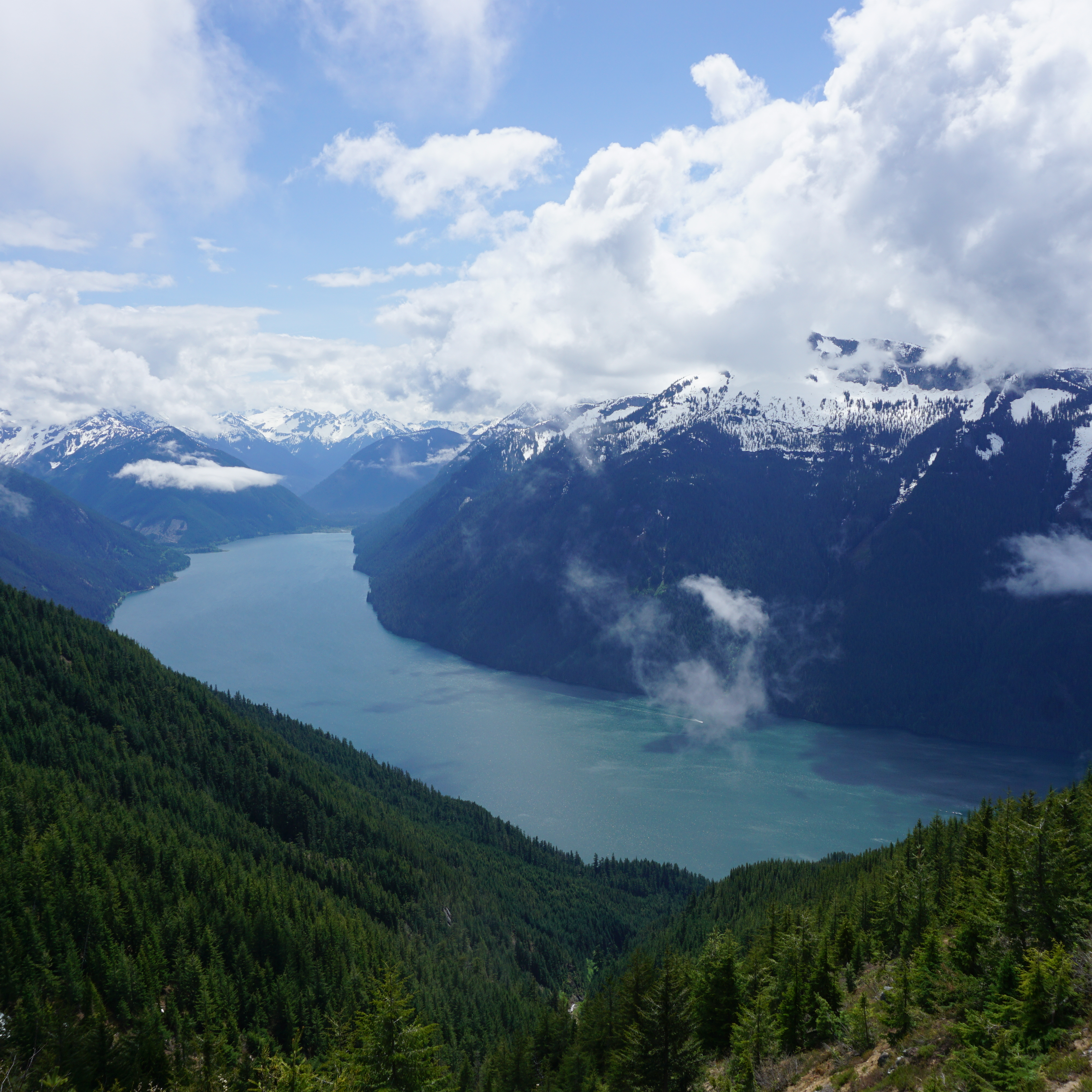
The view of Chilliwack Lake from Flora Peak on a sunny cloudy day, with the snow capped mountains in the background in Chilliwack Lake Provincial Park on the Flora Lake Loop Trail in British Columbia, Canada.

The Flora Lake Loop trail is a 20km trail in Chilliwack Lake Provincial Park that hits 3 alpine lakes and Flora Peak. I’ve never actually hiked the entire trail, but have done large sections of it in both directions. The trail climbs up to Lindeman Lake, which is a very popular trail, and then continues to the back of the lake and up to Greendrop Lake. From there, you continue climbing uphill until you reach Flora Lake. All 3 lakes have campgrounds, but Lindeman Lake is the most frequented.

From Flora, you continue up to the top of Flora Pass, where you have the option to do a side trail up to the Flora Lake Lookout. After the pass, it’s a giant downhill back to the trailhead. There’s 1000m of elevation gain along the hike, so you can either spread it out between campsites when circling the lakes, or reverse the trip and do it all in one go on the way up the Pass. With so many campsites, you can take anywhere from 1-3 nights to complete the trail. A backcountry permit is needed for these campsites and can be obtained 2 weeks prior to your trip at camping.bcparks.ca. 

Frosty Mountain

A landscape photo of the larch trees turning yellow during Autumn, with a snow covered Frosty Mountain in the background on a cloudy day. Taken in E.C. Manning Park, British Columbia, Canada.

Frosty Mountain is one of the most popular Fall hikes near Vancouver, but it makes for a great backpacking trip any time of year. Most people go up and back on the same trail, but there’s actually a 27km loop option that goes around the back of the mountain. There’s a campsite on either side of the summit, so you can do it as a 1 or 2 night trip. There’s also the option to add on a side trip to the PCT monument, Windy Joe, or Lightning Lakes. 

This hike has a lot of elevation gain, more than 1200m, so it’s good to do over multiple days. If you go in the Fall, it will be really busy when the larches turn yellow, but the view from the summit is great year-round. The only downside is having to carry a large backpack over the pass to the summit. A backcountry permit is needed for these campsites and can be obtained 2 weeks prior to your trip at camping.bcparks.ca.   

Tricouni Meadows

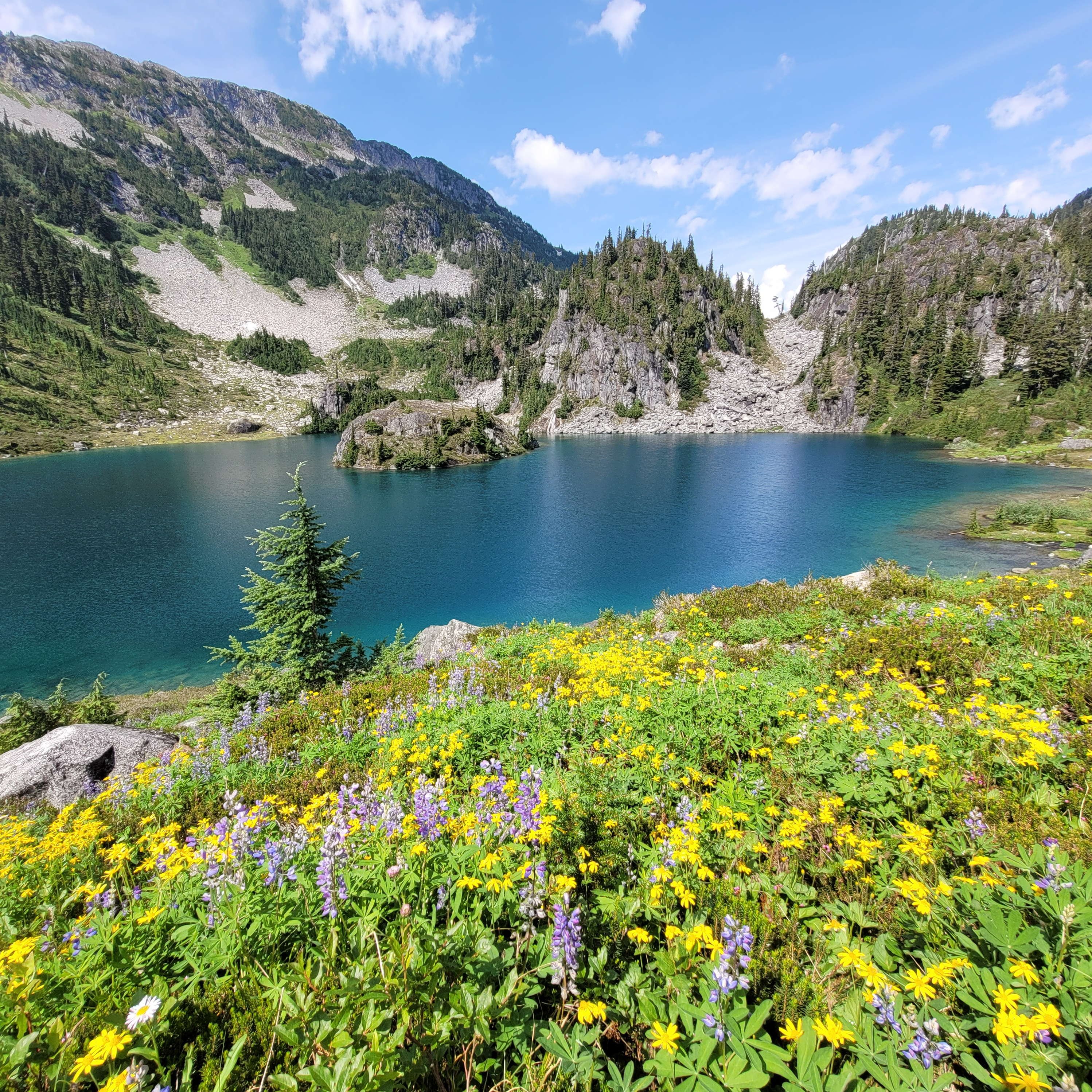
A photo of Pendant Lake on the way to Tricouni Meadows, with yellow and purple wildflowers in the foreground and a blue alpine lake and mountains in the background on a sunny, blue sky day. West of Squamish in British Columbia, Canada.

Tricouni Meadows is a bit of a stretch for a loop hike, but it is a gorgeous trail! It’s located southwest of Squamish and requires driving up Squamish Valley Road, before merging onto Branch 200. 4×4 and high clearance are recommended to access this hike. The climb up Branch 200 is quite steep and there is a pretty big washout a few kilometres before the trailhead. I’ve heard the washout has gotten worse since I visited, so it might be necessary to add on a few extra kilometres walking on the road. The hike up to the meadows is only 4km from the trailhead, so it’s easy to add a few extra kms of road walking without overdoing it.

The loop part of this trail is because you can actually hike up to the meadows on either side of the river to Pendant Lake. The terrain isn’t that different, but it does make for a nice change of scenery. From Pendant Lake, there’s a bunch of camping available, but there are no facilities (bear cache or outhouse). You can do the trip in one night, but there are several lakes to explore and if you add a second night, you could use the extra time to climb up Tricouni Mountain!

Russet Lake

A photo of Russet Lake with the grassy meadows and the mountains in the background on a smoky summer day in Garibaldi Provincial Park near Whistler, British Columbia, Canada.

Russet Lake seems to be one of the lesser frequented trails in Garibaldi Park, but it’s no less scenic than its neighbours. The challenge with Russet Lake is that most people take the Whistler gondola to the top, which costs $100. Fortunately, there are several options available for this hike. For a true loop hike, you can enter or exit from Whistler base by climbing up the Singing Pass Trail, which follows the valley between Whistler and Blackcomb Mountains (and saves you the cost of the gondola). The challenge with this option is that there is over 1200m of elevation gain spread over 15km. Alternatively, you can take the gondola up the mountain and follow either the High Note Trail (from Peak Chair), or the Musical Bumps Trail (from Roundhouse). This route is easier, but still has over 500m of elevation gain spread over 12km, as you summit several small peaks (but is much more scenic)

You only really need one night at Russet Lake, but if you stay a second night, you can explore some of the surrounding peaks. On the way back, you can take any of the 3 trails mentioned above. At the time of writing, Whistler doesn’t ticket on the way down, so even if you hiked up, you can still take the gondola back down at no charge. This hike does require camping reservations, which release 4 months in advance of your date from camping.bcparks.ca.  

Chilcotin Loop

A photo of the hiking trail in South Chilcotin Provincial Park that runs to Lorna Pass. The trail is covered in yellow wildflowers in the middle of the forest, with the mountains peaking out in the background on a cloudy day in British Columbia.

South Chilcotin Mountains Provincial Park is mostly frequented by mountain bikers, but even in peak season, the park is relatively empty. It’s a beautiful park with lots of options for loop trails. If you only have a few days, there’s a nice loop trail around Taylor Creek that is ~26km long and can be explored over 2 nights, with side trips to the High Trail or Camel Pass. If you have more time, there’s a 5-6 night loop in the core area of the park that can be accessed from Tyaughton Creek, which goes over Deer Pass and along the valley to Spruce Lake. It’s ~70km long, but can be extended with side trails up to Lorna Pass, Warner Lake, or Lizard Creek. 

Many of the campsites in the core area are serviced by BC Parks and have bear caches and outhouses, but wild camping is also permitted and there are a few nice sites without facilities if you want to slow down your pace. There are grizzly bears in the park, but since there are so few visitors, they haven’t been known to bother hikers. It’s a remote part of BC that I really enjoyed getting to see.

Tetrahedron Park

A landscape photo of the trees, mountains, and ponds, from the top of Mount Steele in Tetrahedron Provincial Park on the Sunshine Coast of British Columbia, Canada.

Tetrahedron Park is located north of Sechelt on the Lower Sunshine Coast and is another great trail for beginners. The park has 4 huts that are managed by the Tetrahedron Outdoor Club and they are the only option for camping in the park (tenting isn’t allowed, neither is swimming because it’s in the watershed). 

With 4 huts, it’s easy to customize your trip to however many nights you’d like. The loop part of the trail comes from the trail from Edwards Cabin to Mayne Lake and back to Batchelor Cabin, but there are some great side trails to the Mount Steele and McNair Cabins. The hiking is pretty easy, though it can be muddy at certain times of year. The distance is customizable based on your route and could extend from 12-30km. Reservations are made through the Tetrahedron Outdoor Club facebook page and are $15 per person, per night.

Assiniboine

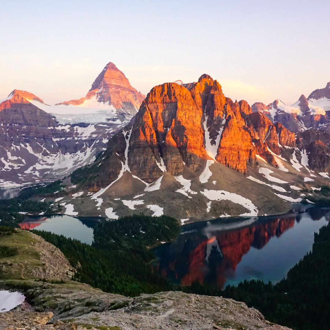
A photo of Mount Assiniboine and Sunburst Mountain and Cerulean Lake at sunset from the Nub in Assiniboine Provincial Park in British Columbia, Canada.

Assiniboine was also on my list of thru hikes, but it’s such a versatile hike, it can also be done as a loop trail! When you enter the park via the Mount Shark trailhead in Kananaskis, you can access Assiniboine through either Assiniboine Pass or Wonder Pass. They share a common trail to Marvel Lake, but then they branch. I’d recommend doing Assiniboine Pass on the way in and Wonder Pass on the way out because it is a steep trail to climb up. There are some restrictions on Assiniboine Pass at certain times of year, so make sure you check for any trail closures.

Once you get to the core area, you can spend a few days exploring the highlights of Assiniboine Park before you return. Not including side trails, the loop is ~52km, so I’d recommend 4-5 nights. It’s a long hike into the park and I personally prefer to do it over the span of 2 days, followed by 2-3 nights in the core area. Both of the entry trails are in Banff National Park and camping permits can be booked through Parks Canada, which release sometime in March for the entire season. Backcountry reservations for Assiniboine are available 4 months in advance at camping.bcparks.ca.

Iceline Trail

A female hiker walks with her hiking poles and hood up, facing away from the background view of large mountains and glaciers on the Iceline Trail in Yoho National Park in British Columbia, Canada.

The Iceline Trail is an incredibly scenic trail in Yoho National Park. The loop trail is 22km and can be done as a big day hike, but it is also nice to enjoy over 2-3 days. The trail leaves from the valley at Takakkaw Falls and climbs up to the alpine for ~6km of exposed trail before going back down to the valley. There are tons of options for camping at Yoho Lake, Little Yoho, Laughing Falls, Takakkaw Falls, or if you’re an ACC member, Stanley Mitchell Hut. 

There are also tons of options for side trails and day hikes, such as Twin Falls, Whaleback Mountain, and the Highline Trail. Reservations are made for the Yoho Backcountry on Parks Canada, and all of the reservations release for the season sometime in March. This is a great alternative trail for those not lucky enough to get permits for Lake O’Hara. 

Lake O’Hara

A photo of red canoes on the bright blue lake water of Lake O'Hara, with the mountains in the background on a cloudy day in Yoho National Park, in British Columbia, Canada.

Lake O’Hara is one of the most popular hikes in the Canadian Rockies. It’s located in Yoho National Park and it is no small feat to secure permits for it. I’ve written an entire blog post on the challenge. You can visit as a backpacker, for which you need camping permits that include a bus ride along the 11km access road. Or you can visit as a day hiker, for which you either need a bus pass, or plan to hike an extra 11km each way. All permits are available from Parks Canada and release some time in March for the entire season.

Once you get to the base, the core trail is the Alpine Circuit, which is approximately 13km if you do the entire circuit. It sounds short, but it climbs through 3 key parts of the trail and shouldn’t be underestimated because of the considerable elevation gain. Fortunately, you can customize the trail to include either the Wiwaxy Gap, the Yukness Ledges, Opabin Prospect, and/or All Souls. The entire hike is in the alpine and one of the most scenic trails I’ve ever done. There’s also lots of options for side trails to Lake McArthur, Linda Lake, or Odaray Grandview.

Blanca Lake Backpacking Trip

I hiked to Blanca Lake around the third week in July and it was the first weekend where it really started to feel like summer. The snow melt was very late in the mountains and I’d been tracking the hike via satellite all week. 5 days before we went, the entire lake was still frozen, but it was melting fast and by the time we hiked up there, it was almost entirely gone. 

Blanca Lake is not a well known hike, but it is starting to get more popular. It’s located pretty far up Squamish Valley Road and it does require 4×4 to get to the trailhead. The hike is only 4.5km, but the road to the trailhead is long and exposed, so I wouldn’t recommend hiking the extra distance on a hot day. We ended up picking up a few hikers along the road and they were about to give up and turn around before we drove by because it was so hot. 

IMG_4755

We had a great crew for this trip. Seth and Sadie both joined me for their second hike of the summer, and of course Brandon was ready with his 4runner. We were also joined by our friend Adriana, who we hiked Tetrahedron with last year, and a new friend, Victoria, who we met when hiking Hozomeen Lake several weeks earlier. I downed a lot of gatorade along the drive as we convoyed up to the trailhead in two cars. It’s a pretty long drive on Squamish Valley Road, as well as on the FSR. The road isn’t in that bad shape, but there are several water bars along the way and a sketchy washout before the top. A few cars parked before the washout as it’s not a long walk from that section.

To make the occasion more special, it was Brandon’s birthday! We ate sandwiches at the car and then started the hike up to the lake. The trail is flat for a short distance, but then you immediately do a big climb up through the trees. It was challenging because it was so hot, but at least we were in the shade. After the climb, the trail stays in the trees and is pretty flat again. You traverse through some small meadows and eventually come to a stream crossing before starting to climb again.

PSX_20240723_212149
20240720_154816

Some of the group was able to get across the stream crossing with their boots on, but I opted to just put on my sandals and wade through it. It was much easier and we all did it on the return trip. We encountered a few groups who were day hiking on their way down, but otherwise we didn’t see a lot of people. You continue through the trees again and then eventually come out on a boulder field that follows the river to the top. Seth really struggled from the heat on this section and the hike took longer than we expected it would, but eventually we all made it to the beautiful wide open view at the top.

20240720_162604

The final section of the trail and the lake are all in the alpine. Blanca Lake is really at the start of the alpine and if you have 2 nights to spare, it’s definitely worth it to stay up there for an extra day and explore around on your own. There aren’t any trails, but the terrain is easy to navigate and you can do a scramble to some of the other lakes and peaks.

Blanca Lake is the biggest lake, but there are several other lakes nearby, as well as a lot of tarns. I decided to swim in Blanca as soon as we arrived and it was so hot even Seth joined me! It was freezing cold (it had literally only finished melting 2 days ago), but it was refreshing. Adriana and Victoria opted to swim in the small lake just below Blanca, which was warmer, and Brandon scoped out a secluded place to pitch our tents by an even smaller tarn. 

PSX_20240722_184903
IMG_4680

There were quite a few people camping on Saturday night. Most of them camped right next to Blanca Lake, but there’s lots of room to spread out. I liked our spot over by the tarn because then Sadie wasn’t distracted by or a nuisance to the other campers. I swam in the smaller lake and 2 tarns, but not the other 2 large lakes. I can’t see any names for them on Gaia, but there’s a big circular lake west of Blanca, and another lake to the South. I hiked over to view both, but they were a bit farther away, so I didn’t swim in either.

We sent up the tents and proceeded to have an excellent evening hanging out in the alpine! We brought party hats for Brandon and celebrated his birthday with some cherry liqueur that I’d brought home from Portugal. We had Brandon’s infamous thai chicken curry for dinner and had a great time hanging out and enjoying the view during golden hour. 

20240720_184458
20240720_200051

There’s no facilities at Blanca Lake, so be prepared to dig catholes for your bathroom. There are some trees around, but it’s pretty barren, so we brought bear vaults and bear bags rather than hanging our food. It should be possible to find somewhere to hang your food, but it was definitely a lot easier using Carolyn’s bear vault, which I borrowed for the trip.

It was an absolutely gorgeous evening and we spent most of the night taking photos of each other. The sunset turned everything orange around us and we shared snacks to celebrate Brandon’s birthday. I made everyone worms and dirt (a girl guide classic!), but I guess our sugar tolerance is lower than my girl guides because we all ate way too much!

PSX_20240809_232610
PSX_1721796972974

I was the first one up in the morning thanks to Sadie. It gets bright so early and she wants out of the tent, so I decided to let everyone else sleep in and take her for a walk. She was my little dog sherpa and carried our essentials in her bag. Like I said, there’s a lot to explore, so we did a short hike up to some of the ridges to view the other lakes and have our breakfast. Blanca is cool, but in my opinion, the lake to the west has the most beautiful view. I wish we’d had more time to explore, but I’ll have to add it to my long list for a return trip.

20240721_074347

We took our time having breakfast and packing up and as a result, we were the last to leave. The campsite was completely empty, so I think it’s really only busy on the weekends. The hike back down the valley was nice and there were a lot of wildflowers around. We stopped for lunch shortly after crossing the river and then continued back to the cars. We stopped at the Water Shed in Squamish for dinner and then closed the books on a really nice weekend in the mountains! I took way too many photos on this trip, so here’s a few more!

PSX_20240809_233207
20240720_192804
20240720_203652
PSX_20240721_210601
20240720_191252(0)
PSX_20240723_071614

Tofino Surfing Trip

I’ve had the opportunity to do some pretty cool things with my girl guides over the years, and this was definitely one of the more unique experiences!

Last year we did a water series that involved kayaking, whitewater rafting, and canoeing. The only activity on our brainstorm that we didn’t do was surfing, mostly because it was too expensive to make a trip to the island on top of all the other activities. This year, we decided to prioritize the surfing trip and dedicated 4 days over the May Long weekend to travel to Tofino.

West Coast Area Trex

I’d never heard of Tofino before moving to BC, but I remember after moving here that Tofino seemed to hold this mythical status for people who grew up in BC. It’s a small town located on the west coast of Vancouver Island. It’s most well known for its premier surfing beaches; but it’s also home to Pacific Rim National Park and fun activities such as hiking, whale watching, kayaking, and hot springs. 

I’ve been to Tofino several times, but I’ve never surfed, so this was a new experience for me. To be honest, I’ve always found surfing to be a bit intimidating. I don’t like getting salt water in my eyes and mouth (inevitable when surfing), so I always avoided it. I was happy to do it for the unit, but it’s not something I would have opted to do on my own. Which is one of the reasons why I’m so lucky to get to spend time with 15 adventurous teenagers every year, because I had a fantastic time surfing!

Long Beach Tofino

We left New Westminster bright and early on Saturday morning of the May Long weekend to catch our ferry from Horseshoe Bay to Nanaimo. It’s a 3-hour drive from Nanaimo to Tofino, so we made our first stop at Little Qualicum Falls to eat a packed lunch. It was raining on and off all morning, but Qualicum Falls has a nice picnic shelter and the rain held off long enough for us to do some exploring around the park to see the waterfalls. 

After that, we drove across the rest of the island to reach the coast. The weather was incredibly variable and there were several downpours along the way, but as soon as we reached the coast, all the clouds disappeared and it was a gorgeous, blue sky, sunny day. We were extremely lucky to be able to book the group campsite at Green Point campground in Pacific Rim, which was just large enough for our group of 18. 

Hiking at Qualicum Falls
Pacific Rim Visitor Centre

After getting set up, we took a walk down to Long Beach before dinner, which is aptly named for its 16 kilometres of uninterrupted coastline. I’ve visited Long Beach several times, but I’d never been to this part of the beach. It’s a golden sand beach, with big waves, and on this occasion, a lot of wind. So it was definitely on the cold side, but we all loved running across the beach and exploring the area.

On Sunday, we had our first surf lesson. We did 2 lessons with Surf Sister School and I would highly recommend. As a female led organization, we loved having female surf guides to show us the ropes. On our first day, we met at Cox Bay Beach. We spent the first part of the day on land, learning how to safely get on our boards and pick our waves. Once everyone was comfortable with the instruction, we got in the water.

Surf sister school Tofino

Surfing isn’t easy, but it was more fun than I anticipated. There was a steady stream of beginner waves rolling into the shore and we all practiced getting on our board. Standing up was almost impossible for me, but it was fun riding the waves on my belly and knees. Of course, once you get going, you become pretty determined to stand! I didn’t have any luck standing on Day 1, but several of the trex members were able to surf and it was fun to watch.

We returned to the campground for lunch and then planned for an afternoon exploring in the National Park. We visited the Kwisitis Visitor Centre on Wickaninnish Beach, which I’d highly recommend. They have tons of great info about the region and natural environment. From there, we did a short hike to South Beach, which is a small cobble beach. We had some excitement on the way when we spotted a bear! It was a great sighting because he was far enough away that us and the bear felt comfortable, and we were able to just watch it for a while. 

Black bear on the beach in Tofino
Girl guides on the beach

South Beach turned out to be one of the group’s favourite parts of the entire trip. We didn’t do much there besides relax in the sun and do some beachcombing, but everyone really enjoyed taking it easy after a vigorous morning of surfing! We had dinner back at the campsite and then drove to Chesterman Beach for a sunset campfire. Tofino has really cracked down on beach campfires in the past few years, so you’re not allowed to have open beach fires anymore. Fires are only allowed at Mackenzie Beach and Chesterman Beach and must be in a contained fire pit. We brought a fire pit with us so that we followed all the rules.

Sunset at Chesterman Beach
Campfire on Chesterman Beach

On Monday, we had our second surf lesson, this time at Chesterman Beach. Our second lesson was mostly in the water and focused more on improving our skills. The general consensus from Trex was that they didn’t like Chesterman Beach quite as much as Cox Bay. The waves were bigger and less consistent, so I think it’s more popular for better surfers. But personally, I had a more successful day! I wouldn’t say that I actually managed to surf, but I did manage to stand twice, so it was nice to feel like I made a bit of progress! Considering that I didn’t want to surf, I was really surprised by how much I enjoyed it. I would definitely surf again, and recommend it to those visiting the area. If you have time for 2 lessons, I think it’s more satisfying because you get to surf more on the second day.

Surfing with Girl Guides
Surfing in Tofino

One of the girls was celebrating her 13th birthday on the trip, so we had the most delicious birthday pie for lunch and then went into town for the afternoon. The girl guides had the opportunity to explore Tofino town on their own and I spent most of my time at the bookstore, Mermaid Tales, which is one of my favourites!

We finished the trip with a visit to Tacofino for dinner. We showed up only 15 minutes before closing (oops!!), but the staff were so wonderful in taking our 18 person order. We had some pretty good camp food on the trip, but the tacos were probably my favourite! We had a campfire to end the evening and everyone reflected on their favourite parts of the camp.

Girl Guides eating pie
Girl Guides at Tacofino

We still had a big final day ahead. It started to rain overnight and we had to pack up everything wet, which is never fun. But we’re really thankful that it didn’t rain during the rest of the trip, so it was a small price to pay! We had a pee break at the Taylor River rest stop on the way back, which has the most gorgeous green river running through. I’ll have to return in the future for a swim!

Our final stop on the trip was to the Old Country Market (better known as Goats on the Roof) in Coombs. The goats briefly came out on the roof for a photo op and we did some exploring around the market for lunch. We picked up some doughnuts from Billy G’s Doughnut Shop to enjoy on the ferry ride home. 

Eating donuts on BC Ferries

I had such a fantastic time on this trip and I hope the girl guides did too! We received funding from West Coast Area’s Muriel Murray Fund and from Disney’s VoluntEars Program (through a parent employee) to do this trip. We’re so lucky to have access to funds to subsidize trips like these for teenagers. Several of the trex members are aging out this year after completing the entire Girl Guide Program from Sparks to Rangers. It is really transformative for girls to be able to go on trips like this, interact with female role models, and build up their skills. So thanks to everyone who’s ever bought girl guide cookies from me or a girl guide!

Guiders at Tacofino