Kayaking Twin Islands

Since we weren’t allowed to travel outside of our health region over the May Long weekend, options for camping were pretty slim in the lower mainland. We’ve been wanting to kayak up Indian Arm since before we bought our own kayaks, and we decided to do a short trip out to Twin Islands on Saturday night.

Carolyn and Steve have a sailboat that they dock at Lonsdale, so the plan was for them to spend the night in Bedford Bay, near Belcarra, we would camp on Twin Islands, and then we could explore around Indian Arm together on the sailboat.

20210522_101353

Me and Seth wanted to leave out of Belcarra, but there’s no overnight parking anywhere in Belcarra (they really need to do something about this, I’m fine to pay for it, but there’s literally no options), so we were forced to leave from Deep Cove instead. Usually we launch from Belcarra around 9am and have no problems with parking, so we figured that would be sufficient for Deep Cove as well. We offloaded the kayaks and all our gear at the main parking lot and then I went in search of street parking while Seth brought everything down to the beach.

I was not prepared for how busy Deep Cove was at 9am. It was completely crawling with other boaters and picnickers. I drove around for ages looking for street parking before finally giving up and parking way up in the bush and walking 15 minutes back to the beach. The boat loading zone has to be one of the worst designed loading zones I’ve ever seen. People were double parked all over the road and the beach in front of the kayak rental shop must have had about 2 dozen paddlers.

20210522_114717

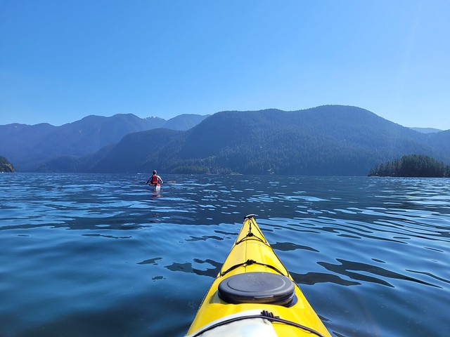
We had offloaded further down the beach, so it was just us and a family of 4 who were loading up their canoe. It was a gorgeous hot, sunny day, so we put on sunscreen before launching into Deep Cove towards Twin Islands. Our plan was to go directly to the island to secure a campsite and then spend the rest of the day around Indian Arm. It was still really calm on the water when we left, so a lot of the paddlers charted a direct course across Indian Arm to Twin Islands. I don’t like paddling in the middle of a huge open body of water for extended periods of time, so we clung to the coast until we were parallel with Raccoon island before crossing Indian Arm.

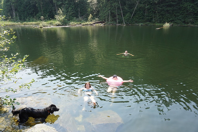
As the name suggests, Twin Islands comprises two islands located very close together. When the tide is low, you can walk between the two, when the tide is high, you can paddle between them. The tide was pretty high when we arrived, so I paddled around to have a look at the two islands. The North Island has steep cliffs along the exterior and the only way to get on the island is from a dock on the north side. In contrast, there is a small beach on the South Island where you can land, so we decided to land there.

20210522_124226

Seth took a quick run around the island, it’s not very big and there were already several tents set up, but he found a nice spot looking north across the inlet. We dragged all our gear up to the site, but decided to relax and have lunch before setting up. Unfortunately, it was then that Carolyn called to tell us they weren’t going to be able to make it out for the day. They had loaded all their gear onto the sailboat and backed out of the marina, only to discover their throttle was broken. They could reverse, but they couldn’t get the boat to go forward! So they were going to have to commit the day to fixing the problem before they could do any sailing.

After we had lunch I heard some other paddlers talking to the people in the campsite next to us about how camping isn’t actually allowed on the south island and debating whether to camp there or not. This came as a surprise to me because I hadn’t read about it anywhere in my research and couldn’t see any signs. We did some quick research since we still had cell service and I was able to find one line on the parks webpage that says “south island is just for day use”. Then I did a walk around the entire island and did find a single sign in the middle with a no camping symbol. We didn’t notice it when we first came in because it’s not visible from the water and another group had literally set their tent up right in front of it.

20210522_114830

So we had a little bit of a dilemma. I hate breaking rules in the backcountry because they usually exist for a reason. In this case, I suspect it’s because there’s no outhouse on the south island. We had come prepared for this because I actually thought there was no outhouse on either island, but my conscience didn’t feel right to camp on the island once I knew you weren’t supposed to, even though clearly other people we’re doing it. To be frank, the entire island was a bit of a gong show. There were boats everywhere and tons of picnickers and campers.

We had wasted time on the south island offloading and eating our lunch and I knew sites were now going to be slim on the North Island as well. So we debated what to do for a while and eventually decided to pack everything back up and skip camping altogether. The day was mostly supposed to be about spending time with Steve and Carolyn and neither of us was excited about camping on a super crowded island. Instead, we decided to paddle around Indian Arm for the afternoon and then return to Deep Cove before dark. It was a little disappointing, but I know we made the right chose not to camp where it’s not permitted.

GOPR3769_1622747539844

At least we hadn’t set up any gear, so it didn’t take too long to repack the kayaks. A dozen people had abandoned their boats on the small beach and neglected to give any thought to the rising tide, so Seth rescued 2 kayaks and a canoe that had started to float away because they hadn’t been tied on. We were both incredulous at such a level of negligence that we weren’t sad to leave Twin Islands behind. I would have liked to check out the North Island at least, but the dock makes it very difficult because you have to carry your kayaks up the gangway and store them on the island, which neither of us wanted to do with fully loaded boats.

We had the current with us, so we decided to paddle up Indian Arm a little way to see the old Buntzen Lake powerhouse. It was a quick paddle along the coast to get to the powerhouse, but the water was getting pretty choppy so I was a little nervous. I read that Indian Arm is best paddled in the early morning or in the evening and that the wind tends to come up in the afternoon. This was our first time paddling in the afternoon and it definitely wasn’t the best conditions. There’s no where to land by the powerhouse so we decided to make our crossing and head over to Thwaytes Landing, a small section of beach that has been designated as a Regional Park.

20210522_135055_03

It was an uncomfortable paddle, especially when any motorized boats would pass us, throwing their wake up over the tops of our kayaks. Normally I don’t have a problem with power boats, but these were not being considerate of paddlers and would speed by very close to us. I know they have the right of way, but they’re a lot faster than me and if they decide to pass right next to me, there’s really nothing I can do about it. It was a choppy landing at Thwaytes, but we had the beach to ourselves. There’s no facilities and it’s one of the stranger regional parks I’ve visited, but it’s great that it exists because there aren’t many rest points for paddlers along the arm.

The waves did die down a little bit while we hung out on the beach, so we decided to re-launch while things were a bit calmer. We didn’t want to go any further up the arm, so we started back the same direction we’d come. The waves had gone down a little, but there was still a pretty strong headwind to paddle against. We definitely got a good work-out and took another break at Brighton Beach, which is across from Twin Islands. It’s not a public beach, but we figured we could break at the end because generally you can’t own the beach below the high tide line (although Seth did some research and there are homeowners that own the beach because they bought the land before this rule came into effect). Unlike the camping rules though, I don’t care so much about this one!

20210522_174131

We were interested in going back to Twin Islands to go for a swim, but we didn’t want to cross the arm again, so we decided to head back to Deep Cove instead. It was tiring and took longer than anticipated, but we managed okay and finally paddled into the cove around 5pm. The water was surprisingly warm, so I decided to go for a quick swim in Deep Cove. Pre-Covid I would always go on a May Long weekend camping trip with my friends and me and Carolyn would go swimming, so I always swim at the end of May and all I can say is the ocean is definitely warmer than the alpine lakes!

I hiked back up to the car and we re-loaded the kayaks and all our gear. I texted Carolyn to let her know we were back and she quickly gave me a call to see if we wanted to come join them for supper since we were still in North Van. So we ended up picking up take-away and eating our dinner on the sailboat sitting in the marina! Not quite the meal we’d planned for the day, but we laughed that at least we finally got to hang out on the boat! We’ll definitely try the trip again in the future, but next time we’ll try to paddle out Friday night instead of Saturday morning to hopefully beat some of the crowds. Or potentially even go on a weeknight because it’s just so busy on the weekends, it does take away from the experience.

So overall, not the trip we planned, but we made the best of it and had some lessons learned about paddling in Indian Arm. Fortunately, since we don’t have to rent kayaks, it’s relatively easy to try the trip again soon.

20210522_211336

8 Great Hikes for Swimming

I love to swim! I’ll hike any trail, but I find hikes with somewhere to swim to be some of the most rewarding trails, especially on a hot summer’s day! A lot of the lakes in BC are fed by glaciers or snow-melt, which makes for a really cold swim, but over the years I’ve become a big fan of those quick, cold dips and will swim in almost any lake from May to October. That said, I’ve tried to focus my list on some of the warmer swimming spots, but we do live in Canada, so to be honest, they’re still all quite cold.

Just a few things to remember before you swim in any body of water. Practice Leave No Trace principles, which means don’t swim in lakes that are also used for drinking water and don’t alter the site in any way or move rocks to create pools. Remove sunscreen, fly spray, moisturizer, etc, before entering the water.

Without further ado, here’s some of my favourite swimming hikes!

Brohm Lake

DSC06113

Brohm Lake is an awesome place to visit in the summer because there’s access to a ton of hiking trails and you can opt to go around the lake, up to the Tantalus viewpoint, or hike through the interpretive forest, finishing each hike with a dip in the lake. The only downside to this hike is that the lake is located right next to the highway and is popular for picnicking – so if you want to make sure you get parking on a hot day, arrive early!

Buntzen Lake

20210418_104713

Located in Anmore, Buntzen lake is a popular attraction for hikers, boaters, and picnickers. This is another location you need to get to early, but it’s a much bigger lake, so there’s more room to spread out. My preference is to hike down to the far side of the lake where there’s a smaller picnic area and wharf with a lot less people. You can either take the lakeview trail, which has minimal elevation, or the Diez Vistas trail, which climbs up over the lake and has beautiful views of Indian Arm. This is definitely a colder lake, but refreshing after a day of hiking!

Deeks Lake and Brunswick Lake

DSC07744
DSC07712

Both lakes are located on the north end of the Howe Sound Crest Trail and are best done as an overnight trip. You can do them in a single day, but it does make for a lot of walking. Deeks is the first lake and a great place to swim, but if you’re willing to walk a few kilometres farther, Brunswick Lake is really the shining gem of the trail. Both are cold, but when the sun hits the water on Brunswick Lake, it turns the most brilliant shade of blue and looks like a tropical paradise!

Elfin Lakes

DSC02679

I feel like most people don’t think about Elfin Lakes for swimming because they’re so small and completely fed by snow melt, but the last time I visited in the summer was a scorching day and I couldn’t get enough of lazing around in the water. Of the two lakes, swimming is only permitted in one – the other is solely for drinking water and swimming is not allowed. I recommend later in the season for this hike because the lake will heat up a lot by the end of the summer.

Alice Lake

DSC05163

When I think of Alice Lake, I tend to think of it more as a frontcountry campground rather than a good place for hiking, but if you’re looking for a shorter hike that can end in a swim, this is a great one! It’s only a few kilometers to walk around the lake, but if you’re looking for something longer you can also extend it to do the four lakes trail loop. Similar to Brohm and Buntzen, get here early to secure a parking spot as you will be sharing the lake with picnickers.

Lightning Lakes

20200508_150708

This is another one that might surprise a few people because Lightning Lakes isn’t one of the warmest lakes, but on a nice day, I really love this lake. Definitely make sure it’s going to be sunny before driving out to Manning Park because it can be really cold and windy on an overcast day, but this is a great place for boating, swimming, and hiking on a hot day. Hike around 1st lake or 2nd lake (or both) and then finish with a dip in the water!

Cheakamus Lake

DSC08885

I’ve only swam in Cheakamus Lake in May, so it was quite cold, but I imagine it probably warms up later in the summer. I decided to include it because it’s a great lake for either day hikes or overnight trips. There are two campsites, one at the foot of the lake and another halfway up, and both have beaches from which you can swim. It’s a big body of water, so it’s always going to be cold, but a great place to hang out and dip in and out of the water.

Lindeman Lake

DSC09886

Lindeman Lake is another one I’ve only swam in May, but I really love this lake. It’s a short, but steep, hike in Chilliwack Provincial Park and you can swim at both the foot and head of the lake. It’s tempting to swim right when you arrive at the lake, but I prefer to hike up to the back of the lake and jump of the rocks into the water from there. It’s definitely another cold one, but has the most gorgeous views!

Hiking Crooked Falls and Sigurd Creek

It’s that awkward time of year when there’s still a lot of snow in the mountains, but we’ve finally reached the time when lower elevation hikes are becoming accessible again! I always play it really safe in the Spring because there are a lot of hazards that accompany the snow melting, but Brandon, Seth, and I went out the last week of May to do some exploring outside of Squamish.

Last Fall Brandon and I hiked High Falls Creek, which was my first time exploring in this area. We did some driving around to see what else was out there and added the Crooked Falls hike to our list – May seemed like the perfect time! Crooked Falls is located on the Sigurd Trail, which is accessible by 2WD and is just across the Squamish River when you pass the rec site.

20210529_161902

It was really busy when we arrived around 10am, but a lot of the traffic appeared to be people camping and fishing on the river. We didn’t actually pass that many people on the way up to Crooked Falls. The hike starts out on an old forestry road that heads up into the woods. It meanders around the side of the mountain before seemingly heading straight up it. It’s only 3km to Crooked Falls and 500m of elevation gain, so it’s definitely steep!

DSC08930

We took Sadie with us on this trip, which was a bit of a challenge because she’s not friendly with other dogs. She did well passing other people, but the trail is pretty narrow and everyone lets their dogs off leash, so we had to pull her into the woods whenever we would encounter another dog to try and avoid a reaction. Overall, it only happened a few times and she mostly was able to handle herself, but she did have one bad reaction to a dog that ran up in her face because it was off-leash. It’s a pet peeve for me – I have no problem with off-leash dogs (we do let Sadie off leash when there’s no one around and it’s permitted), I just wish people would ask consent before letting their dog approach you.

DSC08926

Anyways, back to the trail. Like I said, for the most part we didn’t encounter many people. After 3km there’s a branch off the left side of the trail that heads in towards Crooked Falls. Spring is a great time to visit because the falls are giant with all the run-off. There’s two small viewpoints and you do get a lot of spray off the water (as you can see in the photo), so I wore my rain coat while taking photos. We had a our lunch in the woods where we could stay dry, but still see the falls, before heading back to the main trail. Several other hiking groups came into the falls after us, so it did look like it was getting busier.

PSX_20210603_112800

It was only shortly after noon, so we decided to continue up the trail to Sigurd Creek. My guidebook indicated that hiking another 1.5km would take you to a lookout off the Sigurd Trail. While the falls are reasonably popular, we spent 3 hours on the Sigurd Trail and only saw 1 other person the whole time. It’s not the most well maintained trail and it’s steep and muddy, so I don’t really blame people.

Shortly after you leave the junction from Crooked Falls, there’s a steep 100m side trail that goes up into the woods to a viewpoint. We decided to save it for the way back, but it wasn’t the best viewpoint. It’s a bit crowded in by trees, but you can see the river down below. We continued on the trail until we came to a second junction. To the left is the Sigurd Trail to Ossa and Pelion Mountain, to the right is the Rose Trail to Sigurd Peak. My guide book pre-dated the Rose Trail, so I was a little bit confused where to go at first, but Brandon figured out that what we wanted was to follow Sigurd Creek on the Sigurd Trail and we continued that way.

20210529_130856

Unfortunately our distance tracking was a bit off because the guide book doesn’t include the Crooked Falls side trail, so after 1.5km of hiking we hadn’t reached anything that looked like a viewpoint. We did however stumble upon a second waterfall cascading down from Sigurd Creek. It was lovely and this time we had it all to ourselves, so we had a quick break and Seth refilled his water bladder. Sadie had chilled out a lot and was having the time of her time exploring around the woods.

We decided to push on a little further, but after the waterfall the trail becomes extremely steep and it was slow going. It’s another 400m in elevation gain between Crooked Falls and the viewpoint (on top of the 500m you’ve already done), so it’s definitely no walk in the park. The viewpoint indicated in my guidebook wasn’t shown on my GPS, but I made a guess about where it would be based on the topography. From the trail it really didn’t look like we were close, so Seth was ready to turn around because we were all tired from the uphill. But I persuaded him to push for another 10 minutes to the point on my GPS, because we were really close and I was convinced it was the viewpoint.

DSC08998

Fortunately I was right and a few minutes later we finally crested the mountain and could see a small knoll branching off the trail with a bare top. We climbed up to it and then collapsed while enjoying the view. We stayed up there about half an hour, snacking and guessing what mountains we were looking out at. We could see up the snowy side of Pelion Mountain and out to Cloudburst Mountain. Behind that we could see Black Tusk from a new angle and could see most of Mount Garibaldi peaking around the corner.

DSC08977

It was hot at the summit, so we gulped down lots of water and Brandon shared macarons for a summit snack. Sadie had her summit snack at the waterfall, so we gave her half of her emergency meal to give her a boost after so much climbing. She wasn’t showing any signs of being tired though and was still bounding along the trails when we started to make our way back down again.

Once we got close to the junction again, we heard a lot of people at the falls, so I guess it does still get pretty busy during the day. There were still a few groups of people making their way up, but it was 4pm, so most people were on the way down. Because of the topography, you’re on the back of the mountain, so we lost the sun around 4pm and it was surprisingly dark along the trail, even though the sun doesn’t set until like 9:30pm. Sadie was finally starting to look a little tired and nothing seemed to bother her on the way down.

20210529_165226

All together we ended up hiking about 12km. My book has Sigurd Creek round trip listed as a 9km hike, so it is a bit off. Like I said, I don’t think it accounts for the 300m branch to Crooked Falls, but even so, it’s definitely closer to 10 or 11km round trip and has a whopping 900m of elevation gain in total. So be prepared if you attempt this trail. We had a great time, but we ended up being on the trail for 7 hours and had been anticipating it would be more like 5 hours. Overall this is a great area and I’ve had a lot of fun exploring there over the last year.