ECT Series: Father Troy Trail

One of the things I find hilarious about hiking in Newfoundland is how quickly and frequently the weather can change. I took a lot of videos on my trip home to compile for reels on Instagram and it’s hard to believe any of the reels were all filmed on the same day. The weather loves to go from sun to fog to wind to rain, sometimes all at the same time! Such was our hike along Father Troy Trail in mid June.

20220613_153639

This was my third time hiking Father Troy Trail and I’m always blown away by the scenery on this part of the East Coast Trail. It’s approximately 9km in length and runs from Flatrock to Torbay. Given its proximity to St. John’s and it’s relatively easy rating, it’s a great hike to do when you have limited time – though be cautious because it’s so scenic it’s easy to lose track of time!

20220613_163024
20220613_163054

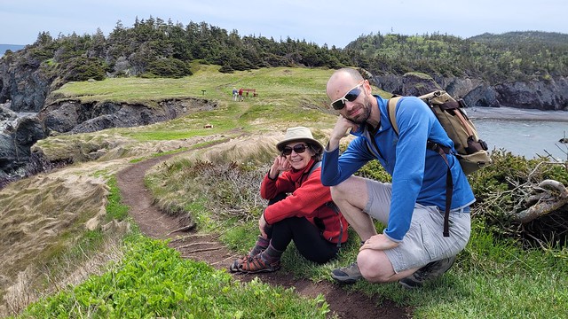
Emily was working the whole time I was home, but she went in early so that she could get off at 3pm and we could hike together. Karen and Grant also recently moved home to Newfoundland and I had a brief window in which to see them when I was there in June. We agreed to meet up in Torbay to ferry a second car to Flatrock to do a thru-hike of Father Troy Trail when Emily got off work. We parked Grant’s car on Spray Lane in Torbay (there’s a small parking lot here) and drove Emily’s car to Flatrock to start the hike.

20220613_153643

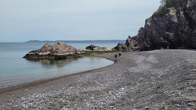
The trail starts right at the public wharf in Flatrock and hikes out along the rock to the point before doubling back on itself. There’s a lovely view of the water and Flatrock from the point, but it’s mostly the same view along the whole point, so we cut across the headland to shorten it a bit on the way in. If it’s your first time on the trail though, I recommend going the whole way to the point!

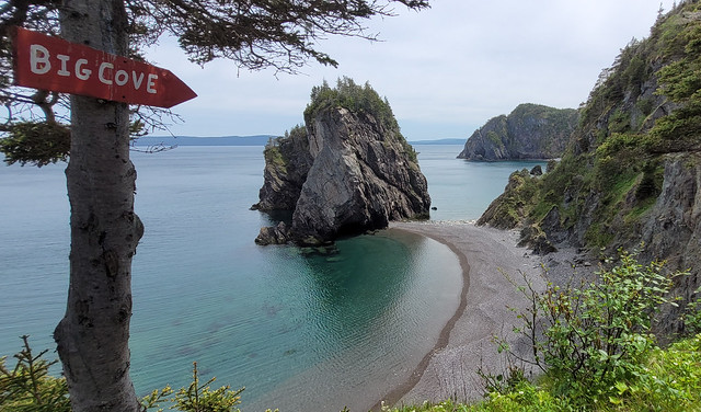
It’s always windy in Flatrock because the wind blows right up over the rock and this trip was no exception. There are some lovely views looking out towards Silver Mine Head Path and the trail meanders along the bluff in and out of the trees. It’s a sheer rock face on the south side of the headland and people rock climb it from below, so use caution along the bluff.

20220613_175342

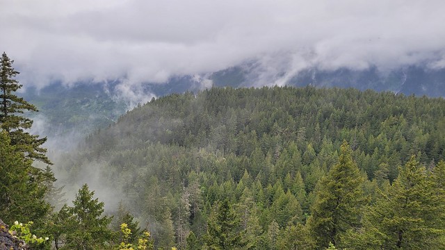
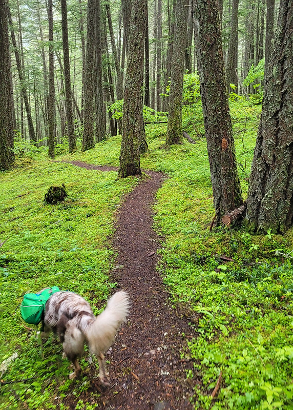
The trail continues in and out of the trees before eventually heading into a wooded section. We started with clear views, but the fog bank that had been sitting offshore all day was on the move with all the wind and every time we popped out of the trees, less and less of the coastline was visible. Before cutting into the woods we got our first whale sighting of the season and spotted a small minke whale fishing off the cliffside. The seagulls were going nuts in the water as well, so we were encouraged that the caplin had likely made it to the island. Eventually we lost the view entirely and cut into the forest for the longer wooded section of the hike. There are a few shortcuts through the woods, but they’re in rough shape, so I don’t think they’re really any faster than the main trail.

20220613_172047
20220613_172259

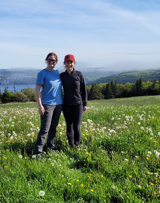
From there the trail continues through the woods along an old road. It doesn’t sound super exciting, but it’s one of my favourite parts of the trail! There’s a really quaint wooden fence and huge fields of wildflowers, behind which you can see the beginnings of Torbay. I believe it’s privately owned farmland, but it’s currently unoccupied, so we frolicked in the flowers for awhile before hitting another parcel of farmland that was occupied by cows. Cows really are some of the sweetest animals, so we stopped for a while to let them stare at us before continuing on.

20220613_175049

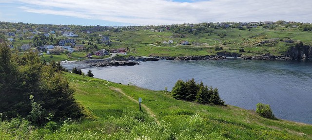
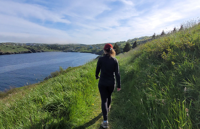
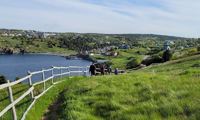
After you exit the woods, you get to my true favourite part of the trail – the hike along the bluffs that form the edge of Torbay. Again, it’s all meadows and farmland, which make for the most idyllic views on a nice day. We were expecting to have completely lost the view to the fog, but fortunately the wind had changed direction again while we were in the woods and we were treated to bright blue water and sunny skies! It’s an easy hike all along the bluffs and we frequently stopped for photos. It’s a steady downhill to Torbay Beach and then it’s just one more short uphill section back to the parking lot on Spray Lane. We cut off ~1km by skipping the point in Flatrock and ended up finishing the hike in just under 2.5 hours, so it was a great late afternoon/early evening hike for us.

20220613_180642

Many sections of the ECT are “one of my favourite trails”, but this definitely still holds true for Father Troy. I’ve hiked it 3 times now and I’d definitely hike it again. At under 3 hours for a thru-hike, you get a lot of amazing scenery! Plus, I loved the opportunity to hike this one with Karen and Grant. A great trail for beginner hikers!

20220613_180552
20220613_175833

Chance Cove Coastal Trail

I recently made my annual summer trip home to Newfoundland for 10 days in early June and had the best time exploring some new trails! I wasn’t thrilled about going home in June because it’s not the nicest weather in Newfoundland at that time, but I ended up having to eat my words because I had really good luck while I was home! I got such fine weather I ended up doing 55km worth of hikes in just 7 days – the first of which was Chance Cove Coastal Trail.

IMG-20220613-WA0016

Chance Cove is located about an hour and half outside of St. John’s on the far end of the Avalon peninsula on the isthmus. Chance Cove has definitely been trending on Newfoundland social media throughout the pandemic and I was starting to feel like everyone I knew on the island had been there over the past year. It looks incredibly scenic in photos, so I admit to being drawn to this hike by Instagram and I was determined to check it out for myself.

We got nice weather on our first weekend home and I convinced both mine and Seth’s families to do the hike with us. It’s only ~4km round trip and is fairly easy terrain, but it’s so scenic it ended up taking us 2.5 hours to do the whole thing!

20220612_124701

What makes this hike especially nice is that it’s a double loop hike (kind of like a figure 8), so you get different topography along the entire hike. We started by climbing up into the woods until we reached Chance Cove Beach, which extends across the cove to the main road, then we switched back to the coastal route up towards Green Head. It was overcast and extremely windy when we started, with Green Head being the most blustery part of the trail. We hiked up to the head, but didn’t stay long because it was so cold, though it was cool to watch the wind swirl erratic patterns through the water.

20220612_124910

From Green Head, you continue along the headland past Chance Cove Island to Island Cove Beach, where fortunately, the headland shelters you from the worst of the wind. There’s a newly constructed set of stairs going down to Island Cove Beach, so we took a long break on the beach to eat our snacks and enjoy the warmer (less windy) weather. As we continued on, the clouds started breaking up and pretty soon the sun was shining down on us!

20220612_131238

The next attraction is Patrick’s Cove (also known as Big Cove), but first you can hike up to a series of viewpoints between the two coves. With the sun shining, it completely transforms the landscape and the water turned the most vibrant shade of blue! You could almost be tricked into thinking you were somewhere tropical, if not for the wind.

20220612_133325

You can also hike down to Big Cove, which has a huge sea stack that is centered in most of the photos I’ve seen on social media. Unfortunately, there are no stairs going to Big Cove, just a large rope guiding you down the bank. I really wanted to see it, so I climbed down, but it’s still really steep and not for the faint of heart. The rope is positioned pretty awkwardly and some of my family members had some trouble, so I wouldn’t go down there if you’re not confident in your abilities. Definitely use caution.

PSX_20220612_182515
20220612_134748

If you do decide to climb down to beach, it is very lovely and would make a great place for a swim. Me and Emily toyed briefly with the idea of going for a dip, but we didn’t have swimsuits and it was a bit too breezy to air dry. We opted instead to wade out up to our knees. It wasn’t quite as cold as I was expecting at first, but it quickly starts to numb your feet and I had to stumble back to the beach to defrost!

PSX_20220615_101406

From there we hiked back up the bank to get what I’d call the “money shot” of the hike. A view from above of the curved beach and sea stack. It was no longer sunny when we got there, but no less scenic! After that it’s a pretty easy walk back to the parking lot. There’s a small climb and then you head back down towards Chance Cove. You can cross the beach if you prefer, but given the wind, we decided to just hike back along the water instead.

20220612_141428

We concluded our day with a visit to Baccalieu Trail Brewing Co. in Bay Roberts to sample some of their beer and “legendary” cod chowder. The sun returned while we sipped our beers on the patio and we congratulated ourselves on a very successful day. Chance Cove Coastal Trail definitely lives up to the hype and I would recommend it to pretty much anyone. Use caution if climbing down to the beach, but otherwise it’s a fairly easy hike that’s great for beginners! We had a great time.

20220612_155122

Tikwalus Heritage Trail Backpacking Trip

Despite the high levels of snowpack hanging around in the mountains this year, I had a good start to the season and got in a second backpacking trip the first week of June. I find Spring backpacking challenging because of the limited number of trails with campsites that are snow free, so me and Carolyn have been trying to branch out to find new trails. This was made somewhat more challenging because we wanted to bring our dogs with us (and even fewer trails are dog friendly), but fortunately Tikwalus Heritage Trail fit the bill!

Tikwalus is located about a half hour north of Hope on Highway 1, just before you reach Hells Gate. As we were driving up there we realized that neither of us had done any hiking in this area and I couldn’t recall ever driving the highway since I’ve lived in BC (though I did it once as a tourist before I moved here). It’s exceptionally beautiful driving along the steep walls of the Fraser Canyon and it doesn’t seem to get that much hiking traffic. Despite not arriving at the trailhead until noon, we were only the third car in the lot! A very promising sign for me since Sadie can be reactive to people and dogs.  

20220528_125416

At 6.5km to the campsite, it’s not an overly long trail, but it is very steep and you gain almost 800m in the first 4km. We took our time going uphill and the dogs had a blast alternating between playing with one another and guiding us up the trail. Sadie is almost 2.5 years now and is an Australian Shepherd, which is a very high energy dog, so she had no problem with the hike and carries her own food and equipment in her Ruffwear pack. Jasper is still a puppy and less than a year old yet, so he was freeloading off Carolyn until he gets old enough for a pack. He got a bit tired early in the hike from the uphill, but he also has a lot of energy and bounced back very quickly once he got used to the climbing.  

20220528_153208

As the name suggests, Tikwalus is a heritage trail and covers both indigenous and colonial history. The trail has been used for many, many years by the Nlaka’pamux for hunting and gathering and there are several culturally modified cedars along the trail. In later years, the trail was used as a trade route through the Cascades by the Hudson’s Bay Company. There are several placards along the trail providing lots of information about the history of the trail, so it made for an educational hike and a nice respite from the uphill monotony on the way in. About halfway up there’s a beautiful viewpoint looking out on the surrounding mountains.  

20220528_140213

Once you get to the top of the steep section (~4km), you’ve done most of the elevation gain and the trail branches into a loop around the summit. If you do it as a day trip, it’s about 13km round trip. It’s mostly flat around the top, so we decided to take the slightly longer lake route to shorten our journey for the following day. Unfortunately there’s not a ton of views around the lake route, but there is a huge viewpoint on the other route. It was clouded over on day 2, so we never got to take advantage of the viewpoint, but it’s still quite scenic at the campsite, so it wasn’t that big a deal. Just something to note if you’re in a similar position as us with the weather. The viewpoint route does go along a narrow spine though, so if you have any issue with heights, the lake route felt a bit safer.

It took us about 3.5 hours to reach the campsite. We didn’t take any long breaks, though we did stop to get water when we crossed over a fast flowing creek on the way up. This was a really good choice because the water options near the campsite are not ideal. There are two creeks on either side of the campsite. I would say the option on the lake route is the better of the two. It’s closer to the campsite (maybe a 10 minute walk?) and it has a decent flow rate. The placard said there used to be a cabin in this area in the past because it was used as a water source. The second option is on the viewpoint route.

20220528_164759

It’s a bit farther (maybe a 15 minute walk?) and it’s not as fast flowing as the other one. To be honest, neither are great, so make sure you bring a filter, I wouldn’t want to rely only on water tabs. I’ve read in some comments online that people get water from the first lake, but I would definitely avoid – it’s very still and a terrible water source. Just walk a bit further to use either of the creeks.

There were two other groups at the campsite when we arrived, but it’s very large and we had no trouble finding a good spot to pitch our tent away from other people. We were joined later by a few more groups, but at no point did it feel crowded. The trail seems to be used primarily for backpacking. We didn’t see a single person on the way up or down, so it seems like most people who go up there plan to stay the night. It’s a mostly forested trail and campsite, but there are some really nice views looking out over the mountains.

20220528_164804

We had really nice weather on the way up and it threatened rain in the early evening, but mostly held off. Campfires are allowed at this campsite and there were several established rings around, so we collected wood debris from around the site and got a small fire going. I’ve done a whole post on responsible campfires, so make sure to only take dead wood and to avoid harming any natural habitat. Fires aren’t permitted in so much of the backcountry (and even when it is permitted there’s often a ban), so it was really nice to have one! We forgot a firestarter, but Carolyn worked some magic to get one going.  

20220528_190008
20220528_165001

The rain finally moved in around 8pm and we decided to call it an early night. It was really just a bit of drizzle, but neither of us wanted to sleep with 2 wet, stinky dogs. However, it was still light, so it took the dogs a while to settle down and we did some reading before falling asleep early. Unfortunately, the dogs get up with the light, so they had us up and awake at 6am. It rained on and off throughout the night, but was mostly mist when we got up. We had a quick breakfast and then packed everything up and were back on the trail shortly after 8am. Quite early for us!

I thought it was going to be a brutal walk down based on how steep it was, but it ended up not being too bad. We saw nothing but clouds from the viewpoint on the return loop, but they lifted enough for us to get a misty view of the mountains at the halfway viewpoint. We finished the hike around noon and stopped into the General Store on the way back to Hope for lunch.

20220529_095612

Overall, it’s a pretty understated hike. It’s mostly in the trees and it is quite steep, but we really enjoyed it. It’s very green in the Spring and we loved that it wasn’t crowded. The large campsite gave us lots of space and we liked the rare opportunity to have a campfire. It was a great choice for taking the dogs and we loved exploring a new part of the region that we’d never been to before and learning a little bit about the history of the area. Would definitely recommend if you’re looking for an early season hike and don’t mind a climb. It is tiring, but it’s not a technical trail, so I think it would be good for beginners looking to build up their stamina and abilities. It has both an outhouse and a bear cache and you can bring your furry friends!  

20220529_104025